
Where Flight Simulation Enthusiasts Gather from Around the World!
AVSIM Library - Search Results

| Category: Prepar3D V1-4 - Scenery | |
| ENRA - Mo I Rana Rossvoll Airport - Nordland, Norway |

|
Images related to this file:
File Description: The Mo i Rana airport, Rossvoll is a North Norwegian airport in the county of Nordland. It is located about ten kilometers northeast of the city Mo i Rana. Operator of the airport is the Norwegian state-owned company Avinor. The Mo i Rana Airport is currently served only by the Norwegian regional airline Wideroe. Scheduled flights go to an from Bodo, Bronnoysund, Mosjoen, Rorvik, Sandnessjoen and Trondheim. The P3D scenery is a partly rework of my FSX-ENRA scenery: Especially the apron lights are made completely new.
The environment of the airport is adapted by new landclasses. The airport has a photo background in two variants, covering all four seasons of spring,summer, autumn and winter. The buildings in this scenery come from the fantastic XPlane scenery of Bert alias "almosquito" who kindly gave me the permission to convert them for my FSX /P3D scenery. But there are also some objects taken from two very popular freeware libraries. If these libraries are not installed, several objects are not visible! Please have a look to the readme_enra.txt. The screenshots are taken from the FSX version. But the P3D version looks quite similar.
| Filename: | ENRA__Mo_I_Rana_Rossvoll_Airport__Nordland_Norway.zip |
| License: | Freeware |
| Added: | 2nd April 2019, 18:48:29 |
| Downloads: | 540 |
| Author: | Wolfgang Allers |
| Size: | 155.53 MB |
| Category: Flight Simulator X - Scenery | |
| ENRA - Mo I Rana Rossvoll Airport - Nordland, Norway |
|
Images related to this file:
File Description:
The Mo i Rana airport, Rossvoll is a North Norwegian airport in the county of Nordland. It is located about ten kilometers northeast of the city Mo i Rana. Operator of the airport is the Norwegian state-owned company Avinor.
The Mo i Rana Airport is currently served only by the Norwegian regional airline Wideroe. Scheduled flights go to an from Bodo, Bronnoysund, Mosjoen, Rorvik, Sandnessjoen and Trondheim.
The FSX scenery:
The environment of the airport is adapted by new landclasses.
The airport has a photo background in two variants, covering all four seasons of spring, summer, autumn and winter.
The buildings in this scenery come from the fantastic XPlane scenery of Bert alias"almosquito" who kindly gave me the permission to convert them for my FSX scenery.
But there are also some objects taken from two very popular freeware libraries.
If these libraries are not installed, several objects are not visible!
The following libraries are used:
1. FS-Piloten_Objektlibrary:
http://www.fs-piloten.de/thread.php?threadid=1063
2. FSX_FlightPortLib
http://www.flightport.de/libraries/flightport-library/
Basically, libraries should be well integrated into the hierarchy of the Scenery.cfg, even below the Add-On-scenery because the Library objects otherwise may not be found by FSX.
| Filename: | ENRA__Mo_I_Rana_Rossvoll_Airport__Nordland_Norway.zip |
| License: | Freeware |
| Added: | 1st August 2015, 21:40:11 |
| Downloads: | 1,510 |
| Author: | Wolfgang Allers |
| Size: | 9.44 MB |
| Category: Flight Simulator 2004 - Scenery | |
| Little Port Walter for Holger Sandmann's Tongass Fjords scenery |
|
Images related to this file:
File Description:
This is a second fish farm at the southern end of Baranof Island and Chatham Strait in southern Alaska. Big Port Walter is named on the chart of the area, and there is a section of the chart included here. Little Port Walter is a much smaller offshoot bay, sheltered from the weather and ideal for a fish farm. This scenery is designed specifically for use in the Tongass Fjord scenery. I may have incorrectly identified Tongass Fjords as being required for Hawk Logging when Glacier Bay is needed. Ah well, it is one or the other of them. The fish farm (or hatchery, the description varies) has an identifying code so it will show up on a gps as PWL. There is no interaction with atc as there are no designated water runways, so PWL on the gps just acts as a waypoint. There will be further posts for use with Tongass Fjords, Misty Fjords, and Glacier Bay, and I still find these scenery areas by Holger and his crew the most satisfying in FS9.
| Filename: | Little_Port_Walter_for_Holger_Sandmanns_Tongass_Fj.zip |
| License: | Freeware, limited distribution |
| Added: | 23rd November 2014, 01:33:12 |
| Downloads: | 233 |
| Author: | Roger Wensley |
| Size: | 3.38 MB |
| Category: Civil Flight Simulators - Looking Glass Flight Unlimited 3 | |
| Channel Islands (add on region) |
|
File Description:
This is a kit to build a new region for the Flight Unlimited 3 game. You have just to move the /channel folder into the /region folder of the game but
the /maps folder has just the blank water tiles and no texture maps due to copyright restrictions. You will have to download the maps by yourself using Maps2BGL and building the tiles using the included automated script. The region includes Jersey, Guernsey and Alderney with 3 prepared airports.
No building or trees are placed, this is left to you and I hope to see a package uploaded at avsim a bit later. To fly in the Channel region you must use a copy of FU3 without the Seattle region or temporarily move the /Seattle folder out of the game (not delete, just move !!!)
This kit also demonstrate how to build a minimal region (8x8 tiles, 131kmx131km. You must learn to handle Maps2BGL to finish the Channel region installation.
A fast Internet connection is needed to download the maps also.
Tool references:
maps2bgl.zip (DLID=120356)
maps2bgl__how_to_.zip (DLID=121257)
| Filename: | Channel_Islands_add_on_region.zip |
| License: | Freeware, limited distribution |
| Added: | 22nd May 2008, 11:31:31 |
| Downloads: | 257 |
| Author: | André Meystre |
| Size: | 22.91 MB |
| Category: Flight Simulator X - Scenery | |
| California Central Coast with Megascenery Earth and FSGenesis Mesh |
|
Images related to this file:
File Description:
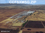
California Central Coast Scenery for FSX with Megascenery Earth and FSGenesis mesh. CCFSXMSG.ZIP covers the California coastal region from N36° 10' (Coalinga) to N34° 25' (Santa Barbara) and from the coast East to W119° 40'. It is a version of my previously created California Central Coast scenery redesigned and expanded to work with FSX MegaScenery Earth and FSGenesis USA Terrain Mesh for FSX V2 by Justin Tyme. Airstrips in the area covered by this scenery have been added for a total of 27 airports and airstrips. 6 imaginary water runways are also added for AI float plane traffic. Several other areas of interest such as the Santa Barbara marina, Morro Bay, etc. are included for a total of 41 points of interest. All airports, airstrips and related structures have been adjusted and realigned to conform to actual positions and dimensions as indicated by the MegaScenery Earth satellite textures. Megascenery Earth California-13, -14 and -15 are required and -12, -28 and -29 are recommended. By Al Wheeler 9/25/09.
| Filename: | California_Central_Coast_with_Megascenery_Earth_an.zip |
| License: | Freeware |
| Added: | 7th January 2010, 19:54:57 |
| Downloads: | 870 |
| Author: | Al Wheeler |
| Size: | 8.13 MB |
| Category: Flight Simulator X - Scenery | |
| YGNW Gnowangerup Shire airstrip and town, Western Australia |
|
File Description:
YGNW Gnowangerup Shire Airstrip. The Shire of Gnowangerup is a Local Government Area in the Great Southern region of Western Australia, about 120 kilometres north of Albany and about 370 kilometres southeast of the capital, Perth. The Shire covers an area of 4,268 square kilometres, and its seat of government is the town of Gnowangerup. Gnowangerup was initially gazetted as a Road Board in 1912, taking in eastern sections of Broomehill and Tambellup. On 1 July 1961, it became a Shire Council following changes to the Local Government Act. The area of gnowangerup is mainly wheat sheep on sandplain country. In the 1960's it was reported to have good rainfall but when the clearing started, the rainfall changed. Farmers who managed large properties were able to survive because of the economies of scale. At regular intervals, farmers in this area now have to cart water for their stock. REQUIRES Blencowe_LibraryKit.zip
REQUIRES blencowe_librarykit_309494.zip (Available HERE)
| Filename: | YGNW_Gnowangerup_Shire_airstrip_and_town_Western_A.zip |
| License: | Freeware |
| Added: | 28th February 2013, 02:44:27 |
| Downloads: | 261 |
| Author: | Alan Blencowe |
| Size: | 5.39 MB |
| Category: Flight Simulator X - Scenery | |
| YRDY Reedy's Gold Mine, Western Australia |
|
File Description:
YRDY Reedy's Mine open cut was closed in 1997 but further exploration drilling is under way. Reedy is an abandoned town in the Murchison region of Western Australia. The town is located between Cue and Meekatharra in the Mid West region of Western Australia. Gold was discovered in the area by H Reed in 1899-1900 and a nearby well, Reedy's Well, was named after him. The well appeared on maps of the area in 1908 as a known water source. Further gold discoveries were made in the 1930s and sveral mines were developed. By 1933 the Cue-Day Dawn road board petitioned for a townsite to be surveyed and declared. Suggestions for the name of the town included Triton, Mathers and Reedy. The town was gazetted in 1934. If you fly over, you will note that the airstrip runs down the main streets of the old town. REQUIRES Blencowe_LibraryKit.zip
REQUIRES blencowe_librarykit_309494.zip (Available HERE)
| Filename: | YRDY_Reedys_Gold_Mine_Western_Australia.zip |
| License: | Freeware |
| Added: | 28th February 2013, 14:01:09 |
| Downloads: | 226 |
| Author: | Alan Blencowe |
| Size: | 8.99 MB |
| Category: Flight Simulator 2004 - Scenery Design | |
| Simple Instructions for Modifying Land Class |
|
File Description:
Simple Instructions for Modifying Land Class
Land classification, or land class (NOT "landclass"), is how Flight Simulator depicts the ground textures. For much of the FS world, the ground is not representative of the real thing, however. There have been complaints because of this from those who do not understand the cause of the problem.
This document explains the basic concepts behind the land class system, why it is inevitably inaccurate for most of the world, and the very easy-to-use tools with which to fix this.
Also includes instructions for modifying water class.
This is an html document for universal compatibility.
You do not have to be a computer programmer in order to change the land class. Anyone can do it quickly and easily.
So, why complain about it? Do something!
Very sorry - no support of any kind is offered for this document. Please consult the AvSim Scenery Design forum for any questions.
| Filename: | Simple_Instructions_for_Modifying_Land_Class.zip |
| License: | Freeware |
| Added: | 6th February 2005, 04:24:20 |
| Downloads: | 5,071 |
| Author: | Luis, scenery design forum |
| Size: | 2.18 MB |
| Category: Flight Simulator 2004 - Scenery | |
| The Greater Toronto Area Part 1 |
|
File Description:
Part 1 of Flight Ontario's scenery for the Greater Toronto Area and Southern Ontario.
Over a year in the making, this scenery for Fs 2002 and Fs 2004 is bounded by Detroit in the west, Kingston in the east, Huntsville in the north and Buffalo in the south and features:
* all-season scenery
* custom water textures
* completely modelled Toronto Airports...CYTZ (Toronto Island) and CYZD
(Downsview-home to Bombardier Aerospace and the Canadair Regional Jet
and Dash-8, and the Toronto Aerospace Museum)
* custom autogen for the GTA
* Custom landclass for southern Ontario
* custom shorelines (western Lake Ontario, Kingston area, Lake
Couchiching...Severn River...Sparrow Lake area, and the Muskoka Lake
area)
* prominent features around Hamilton include the Burlington Skyway and
Lift Bridge and steel mills
* the Welland Canal is featured with lift bridges, bascule bridge and
fixed link bridge from Pt Weller to Pt Colborne
* the Niagara area includes the Minolta Tower, and 3 hydro generating
plants with reservoirs
* compatibility with SimFlyers CYYZ
This scenery is downloadable in two parts and both parts are essential
| Filename: | The_Greater_Toronto_Area__Part_1.zip |
| License: | Freeware |
| Added: | 9th April 2004, 12:40:02 |
| Downloads: | 37,176 |
| Author: | Flight Ontario |
| Size: | 62.09 MB |
| Category: X-Plane - Original Aircraft | |
| A1 Spec. SL-1 |
|
File Description:
The Sealiner 1 A1 Special is a small amphibian jet, capable of landing both on land and water as well as other tough terrain, This iarcraft boasts 6 compact low bypass jet engines, The plane also has a nice and simple cockpit design, so simple this is a perfect plane for any first time pilot. Not only is it fast and user friendly but it is safe with a huge chute on it, it can slow this plane down to landing speed in seconds. Unlike the VTOL aircraft I built before this plane is much smaller and this is reflected in the amount of payload it can carry, but there is a good reason for this. This airplane was designed to service small islands (mainly in the south pacific) where before a boat would have had to been taken if one decided to leave, so with the SL-1 them and 20 other people can fly commerical airline style almost anywhere! In the future look for another engine to be added.
| Filename: | A1_Spec_SL1.zip |
| License: | Freeware, limited distribution |
| Added: | 25th April 2004, 01:57:41 |
| Downloads: | 568 |
| Author: | Sam Hoy |
| Size: | 48.1 KB |
© 2001-2026 AVSIM Online
All Rights Reserved
Privacy Policy |