
Where Flight Simulation Enthusiasts Gather from Around the World!
AVSIM Library - Search Results

| Category: Flight Simulator 2004 - Scenery | |
| Silver City CFQ5 in Yukon Territory Canada |

|
Images related to this file:
File Description:
Silver City is a ghost town in the Yukon Territory, Canada, amid the Rocky Mountains and around 35 miles northwest of Haines Junction. It is on the southern end of Kluane Lake and in the Kluane National Park and this probably explains it's (minimal) survival after what appears to have been the shutdown of mining for silver. There is little information readily available. The date of this scenery is, as usual, around 2010. There was no recent regular service by Yukon Air North or any other airline, and the primary user of the airfield adjacent to the lake is a company called Icefield Discovery Tours. Their activity is probably very similar to the company at Haines Junction and involves trips to the National Park amid mountains and glaciers. There is also another organisation at the airfield, the Kluane Lake Research Station of the Arctic Institute. They have four buildings there but it is unclear how much aerial activity they generate, or if in fact they fly at all for their work. The runway is 3,000 feet of unlit gravel, aligned north-south. This post will be followed by Burwash, which is at the far northwestern end of the lake. There is no video of the Silver City airfield on Youtube, and it is not the most exciting airfield in the world, but the location is enough in real life for a visit to be made. On YouTube there is a series of posts by Angle of Attack showing the preparation and then the flight of an old Cessna 172 from Homer to Oshkosh for the installation of modern instruments. Interesting for me as they visit or fly over airfields I have made: Homer, Merrill, Tok Junction, Burwash, Silver City, Haines Junction, Watson Lake, Fort Nelson, and Grande Prairie. But they fly in the winter so it all looks very different.
| Filename: | Silver_City_CFQ5_in_Yukon_Territory_Canada.zip |
| License: | Freeware, limited distribution |
| Added: | 22nd January 2022, 21:57:41 |
| Downloads: | 97 |
| Author: | Roger Wensley |
| Size: | 9.86 MB |
| Category: Flight Simulator 2004 - Scenery | |
| Alaska South Slope 9; Wales IWK |
|
Images related to this file:
File Description:
There are four main northwestern Alaska towns which are serviced by Alaska Airlines, and from which local flights spread out. The northernmost is Barrow. Southwest of Barrow is Kotzebue, then Nome, and the furthest south is Bethel (not yet made). This is the second in a series for local flights from Nome, and it is on the furthermost mainland western point of Alaska, Wales IWK. It is 110 miles northwest of Nome and on the eastern shore of the Bering Strait, with a view of the two Diomede Islands. Wales is a small village with a population of only around 145, strung along the beach on a single road. The airfield is at the northwestern end of the village, with a runway of 4,500 feet of lit gravel aligned 35-17 and an apron at the southern end. There are scheduled flights by the usual Era and Bering Air, both of them originating in Nome and also visiting Shishmaref. The AI includes these flights along with Northern Air Cargo and GA. The runway is just long enough to accomodate a DC6 (as is Shishmaref) and I have revised the AI to include this, along with a revision of the parking at Shishmaref. To the southeast of Wales is Tin City, which was built as a base for the support of radar on the hills between the two. The radar is now automatic and unmanned and the base is unused except for the annual maintenance and fuel supply; I have left the airfield untouched but I have added the hilltop radar and the remains of the cable lift, which was used to get the material for the original station up to the top from the beach below.
| Filename: | Alaska_South_Slope_9_Wales_IWK.zip |
| License: | Freeware, limited distribution |
| Added: | 22nd October 2016, 01:26:24 |
| Downloads: | 570 |
| Author: | Roger Wensley |
| Size: | 3.77 MB |
| Category: Flight Simulator 2002 - Scenery | |
| Caticlan-Boracay Version 2003 |
|
File Description:
Caticlan Airport is located in Malay, Aklan, northwest of the island of Panay, Philippines.
Boracay Island ,meanwhile, is the internationally known tourist spot destination for travellers and vacationers worldwide for its COOL WHITE SANDY BEACHES. Caticlan Airport is the gateway to BORACAY ISLAND due to its close proximity to the island resorts. Today,Asian Spirit serves the MANILA-CATICLAN route with a total of 9 flights daily,and the CEBU-CATICLAN route with a total of 2 flights daily. Southeast Asian Airlines (SEAIR) also serves Caticlan with 10 flights daily from Manila and 1 flight daily from Cebu. Other smaller airline companies also serve the Manila-Caticlan route such as Pacific Air.
This CATICLAN-BORACAY SCENERY features the most real replicas of structures in Caticlan airport.It features the Godofredo P. Ramos Airport Terminal building, Air Transportation Office and Pacific Air Terminal Building, Crash and Fire Rescue Station, Old Caticlan Control Tower, Pactrans Building, Asian Spirit Departure Lounge, Alice in Wonderland, the new Caticlan Control Tower Complex, Duty Free Philippines-Caticlan and the Caticlan Pier area.
Boracay Island also features different aqua sports activities in most realistic forms such as Jetskiing, Windsurfing, Banana Boating, Parasailing, Catamaran Sailing, Birds Watching, Girls Watching, and a static volleyball tournament along the White Beach area. Also featured in Boracay Island are the following resorts: FRIDAY'S BEACH RESORT, CLUB PANOLY BEACH RESORT, WILLY'S ROCK BEACH RESORT and LORENZO SOUTH BEACH RESORT. Shipping Companies are also featured in the nearby vicinity of the Boracay Oceans such as WG&A SUPERFERRY2, CEBU FERRIES and SULPICIO LINES' PRINCESS OF THE UNIVERSE.
Caticlan-Boracay Scenery Version 2003 is developed for FS2002 by Ver Walter L. Gulfan and the Philippine Flightsimmers Group, with the aim of helping promote the Boracay Island and Philippine Tourism. (A Caticlan-Boracay Scenery version for FS2004 will be released soon).
Inclusions in this release: 1. RPVE afcad file 2. RPVE scenery.cfg file 3. RPVE TTools airports.cfg file 4. RPVE and Caticlan VCPMOD file for Editvoicepack.
| Filename: | CaticlanBoracay_Version_2003.zip |
| License: | Freeware |
| Added: | 20th August 2003, 17:43:24 |
| Downloads: | 2,864 |
| Author: | Ver Walter L. Gulfan/ Philippine FlightSimmers Group |
| Size: | 10.17 MB |
| Category: Flight Simulator 2004 - Scenery | |
| LIMN Cameri, Italy (UPDATED v2) |
|
Images related to this file:
File Description:
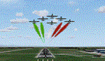
This scenery is a homage to the great military airport of Cameri NO, Italy; it has been revised with complete new ground that solves the previous flickering problems; it is builded-up with ownmade GMax objects and other existing ones; some buildings by GMax, remainder by others and by Generic Building system.
Information: Built during 1910 close to Novara, it became a prestigious Flight School where a lot of pilots of WWI where trained. Later, Gabardini/CANSA entered by promoting and developing aviation activities, mainly establishing a military flight school. On 27th July 1914, first of story's time, a flight from Cameri crossed the Alps (Camery - Viege, over Monte Rosa) with a Gabardini 80HP aircraft and pilot Achille Landini together with Giuseppe Lampugnani passenger. On 1930 the school closed, but the field still remained as aviation workshop. During the WWII the airport was quite destroyed by the german army, during their retreat. After the war, the rebuild operations carried on to Cameri several details, of which the acrobatic patrol of "Lancieri Neri" and, 1967-1999, the great 53th "Stormo Caccia". On 1998 the storm was moved to Gioia del Colle airport and the base was restructured as Comand Airport, where some technical departments still works (the 453th Operative Technical Services Group, the 553th Logistic Operative Services Group and, mainly the 1st Aircrafts Maintenance Dep.nt)
Contents: all around new great terrain for about 4.5 x 3.5 km; static aircraft inside hangar as Tornado, Eurofighter and historic monoliths at admittance and inside airport; ground equipments, cars outside and inside airport, bus, tankers, emergency trucks; military shelters (10) and workshop ones (5); buildings outside/inside airport, control tower, VOR, radar tower and some other navaids; lights at hangars, admittance and all over the boundaries; more then 10 km boundary by walls and fences of the complete areas; thousands trees all over the scenery. This scenery includes the airport scenery content only. You can find separate further sceneries for Babini Army station and Museum
| Filename: | LIMN_Cameri_Italy_UPDATED_v2.zip |
| License: | Freeware |
| Added: | 20th October 2011, 00:20:05 |
| Downloads: | 2,357 |
| Author: | Aldo Della Vedova, Daniele Lanfranchi |
| Size: | 25.08 MB |
| Category: Flight Simulator 2004 - Scenery | |
| Coal Harbour CAQ3 float base in British Columbia, Canada |
|
Images related to this file:
File Description:
This is number eight in a series of new and renovated float bases in BC. Coal Harbour is in a sheltered cove off Holberg Inlet on the northwest coast of Vancouver Island, close to the village and 10 miles southwest of the Port Hardy float base. There is 100LL fuel and oil available. Due to the deep fjords that run into Vancouver Island from the west coast Coal Harbour is actually closer to the east coast than it is to the west coast. The tortuous route in through Quatsino Sound and Rupert Sound shelters the waters of Holberg Inlet from the stormy seas of the west coast, and fishing boats take advantage of this. The floatplane dock is to the south of the large (and old) hangar, adjacent to the southern end of the fixed dock where the ramp bridge descends to the floating docks. The video makes it clearer. The AI is a further adaptation of the CF36 AI and involves Beavers and Otters as listed in the AI folder. Due to the surrounding hills there may be some interference with AI aircraft, depending on the wind direction, though I have watched succesful Beaver and Otter landings. Amid the hills there is a very large hole in the ground to the east. The village name suggests it may have been for coal but though in fact there was a coal mine, that was a much smaller and unsuccesful venture; this particular scene of enthusiastic digging was for copper, until 1996. The main claim to fame of Coal Harbour was that it was the last whaling station in North America, using the buildings that were part of the RCAF float plane patrol base during WW2. One downloader reported a texture problem with Port McNeill, to which we found a solution. As he was the only person to email me I am going to presume that nobody else had the problem.
| Filename: | Coal_Harbour_CAQ3_float_base_in_British_Columbia_C.zip |
| License: | Freeware, limited distribution |
| Added: | 25th January 2017, 00:29:05 |
| Downloads: | 225 |
| Author: | Roger Wensley |
| Size: | 7.79 MB |
| Category: Flight Simulator 2002 - Aircraft Repaints, Textures and Modifications | |
| Canadair CL-13 Mk 2 Sabre (F-86E) Royal Hellenic Air Force |
|
File Description:
This is one of the first jet age aircrafts served in Royal Hellenic Air Force, almost 50 years ago (!!!). There are two repaint versions of Royal Hellenic Air Force in the zip package: The first one, represents a Royal Hellenic Air Force Canadair CL-13 Mark 2 Sabre used to fly with 342nd Sqdr. of Royal Hellenic Air Force (RHAF) in Elefsina, Greece with an interception role. The second, represents the aniversary "Alexander the Great" texture, painted in "patriotic" colours, by a gas station owner (!!!) in Thessaloniki - Greece after buying the aircraft (sn. 19294) as scrap and finaly display it as a memorial by his store. This specific aircraft used to fly with 343rd Sqdr. In Nea Anchialos, Greece. The Canadair CL-13 Mark 2 Sabre aircraft (Canadian build F-86E under North American licence) used to be one of the most succesfull aircrafts during the 50'ies and the Korean war. This "CL-13_RHAF_v1.zip" package is full compatible with FS2K2 and FS9 too and contains realistic sound made by Angelos Hatzikatakos, NEW (made by the author) panel, the official checklist and a VERY completed (as always...) flight manual (31 pages) which can be read with Adobe Acrobat. This repaint was based on the original model made by Rey Lopez . The primary panel was made by Ken Mitchell and modified by Nick Karatzides to look more realistic and closer to the Hellenic CL-13 Mk 2 cockpit. A total NEW flight model ("air" file and aircraft.cfg file) have been created by Nick Karatzides and and I test it hard, to ensure that it flies as close as possible like a real fighter! This "CL-13_RHAF_v1.zip" package is for EXPERIENCED FlightSimers and virtual pilots who have a "good feeling" on the stick and do not "kick" the contol stick while flying. The package contains new visual effects, night lighting, fine looking mechanical parts movement, contrails, realistic gears extracting / retracting etc. Repaint and stuff by Nick Karatzides.
| Filename: | Canadair_CL13_Mk_2_Sabre_F86E_Royal_Hellenic_Air_F.zip |
| License: | Freeware |
| Added: | 4th October 2003, 00:15:30 |
| Downloads: | 1,408 |
| Author: | Nick Karatzides |
| Size: | 11.28 MB |
| Category: Flight Simulator 2004 - Scenery | |
| 8AK7 - Bullen Point - Alaska North Slope 7 |
|
Images related to this file:
File Description:
The town of Barrow is in the far north of Alaska, and these are coastal villages or radar installations to the west, south, and now east of Barrow. There will be further additions. Bullen Point is a DEW station Air Force base 240 miles east of Barrow and 75 miles east of Oliktok. The runway is just under 4,000 feet of gravel and aligned 05-23; this is approximately at right angles to the default FS9 alignment and how that came about is something I doubt Bill Gates could explain. Most of the DEW buildings have now been removed (including the large hangar, which is unusual) but as I had a layout I made the whole site as it was originally, way back in the days when the north slope was still a wilderness. The AI is one day a C-130, on another a Cessna, and on a third a DC3. When I started this North Slope series it was my intention to create the full monty and make all the oil and gas installations and Deadhorse airport etc. I have come to realise that the oil side is impossible to make. There is so much of it and each bit is as time consuming as Heathrow while the actual airfields are more like Rockcliffe CYRO, so a lot of effort for what is just background to an adjoining airfield. But at the same time, if I make the new airstrips it is impossible NOT to make the oil installations as they are the dominating feature. So no new airstrips, and this is going to be just the 1960's or 1970's, when the oil business was only exploratory and the airfields were for villages or DEW stations, and Harmon Helmerick had his dirt strip on the Colville River estuary and was guiding hunters and fishermen and had just started to help out Sinclair Oil with oil exploration in 1966. Read his book. Download my previous post of his field.
| Filename: | 8AK7__Bullen_Point__Alaska_North_Slope_7.zip |
| License: | Freeware, limited distribution |
| Added: | 15th July 2016, 17:46:54 |
| Downloads: | 278 |
| Author: | Roger Wensley |
| Size: | 2.5 MB |
| Category: Flight Simulator X - Scenery | |
| RAF Polebrook |
|
File Description:
On June 28, 1942, RAF Polebrook was officially turned over to the USAAF and the airbase became the base of the 97th Bombardment Group, the first USAAF heavy bomber organization to arrive in the UK. It was designated USAAF Station 110.
The 97th BG was assigned to the 1st Combat Wing, at RAF Bassingbourn. It's operational squadrons were divided between Polebrook and RAF Grafton Underwood:
340th Bomb Squadron (RAF Polebrook)
341st Bomb Squadron (RAF Polebrook)
The 97th BG conducted a total of 14 missions from Polebrook, attacking airfields, marshalling yards, industries, naval installations, and other targets in France and the Low Countries.
The group sortied 247 aircraft, dropped 395 tons of bombs on Nazi-controlled territory, and lost 14 aircraft. On October 21, 1942, the 97th Bomb Group was transferred to the Twelfth Air Force in the Mediterranean theater and Polebrook was unoccupied until April 1943.
351st Bombardment Group (Heavy)
On April 15, 1943, the 351st Bomb Group arrived at RAF Polebrook. It was assigned to the 94th Combat Wing, also at Polebrook. The group tail code was a "Triangle J". It's operational squadrons were:
508th Bomb Squadron (YB)
509th Bomb Squadron (RQ)
510th Bomb Squadron (TU)
511th Bomb Squadron (DS)
Boeing B-17G-85-BO Flying Fortress, Serial 43-38465 of the 510th Bomb Squadron. This aircraft survived the war and returned to USA on 8 June 1945
Douglas-Long Beach B-17G-30-DL Flying Fortress Serial 43-38116 of the 509th Bomb Squadron.The 351st's first completed combat mission took place on May 14, 1943, when 18 B-17's targeted a German Luftwaffe airfield at Kortrijk, Belgium. As the war progressed, the 351st operated primarily against strategic objectives in Germany, striking such targets as ball-bearing plants at Schweinfurt, communications at Mayen, marshalling yards at Koblenz, a locomotive and tank factory at Hannover, industries at Berlin, bridges at Cologne, an armaments factory at Mannheim, and oil refineries at Hamburg.This is for FSX and you will need to have Ted Andrews's RAF Hangars Library and his other great RAF Buildings. They can
be found on AVSIM. Search the FSX section for "Ted Andrews" - you'll find loads of his scenery object files for
RAF airfields. Follow his instructions on how to install them.
| Filename: | RAF_Polebrook.zip |
| License: | Freeware |
| Added: | 21st January 2009, 13:27:45 |
| Downloads: | 1,058 |
| Author: | Scott Berge |
| Size: | 15.01 KB |
| Category: Orbiter - Spaceships | |
| U.S.S. Enterprise 2702-D |
|
File Description:
The U.S.S. Enterprise NCC-1701-D was a Galaxy-class extended-duration starship and the flagship of Starfleet. The fifth starship to be named Enterprise, she was commanded by Captain Jean-Luc Picard. With a total of 42 decks, the U.S.S. Enterprise-D was twice the length and had eight times the interior space of the Constitution-class ships of over a century earlier; she carried a combined crew and passenger load of about 1,012.
Defensive systems included 10 phaser banks, 250 photon torpedoes, and a high capacity shield grid; there are some 4,000 power systems in all aboard ship.
Full acceleration time from reverse, sub-light impulse through nominal top warp speed, warp 9, was 0.03 milliseconds. The ship achieved maximum speed of warp 9.5 maximum when pursued by the entity known as "Q"; at warp 9.3 its engines had passed the red line.
By stardate 43205, she had already logged tens of thousands of light-years since setting out around stardate 41153.7 after Jean-Luc Picard formally became her first captain on stardate 41124.
An average day aboard ship, according to Lieutenant Commander Data, included four birthdays, two personnel transfers, two chess tournaments, a secondary school play, four promotions, the celebration of the Hindu Festival of Lights — and a birth and wedding.
Some 13 planets were represented among the ship's complement as of stardate 44247. During the Borg incursion of 2366, Decks 23-25 were sliced open by the enemy during the final battle over Earth and requiring a refit at Earth Station McKinley which lasted 5-6 weeks.
It was far less damage than the kamikaze warp-driven collision Commander Riker had readied as one last recourse, however. During that refit, the starship received a phaser upgrade as well as damage repair and a dilithium chamber articulation frame. It off-loaded the original three Runabouts and the first arriving officers at Deep Space Nine.
The U.S.S. Enterprise-D was destroyed in 2371 after an attack by renegade Klingons breached her warp core. Although the saucer section separated before the breach, the force of the explosion caused the section to crash on the planet Veridian III. Fortunately, losses were minimal.
| Filename: | USS_Enterprise_2702D.zip |
| License: | Freeware |
| Added: | 12th July 2004, 04:41:12 |
| Downloads: | 2,212 |
| Author: | Jim Williams |
| Size: | 1.45 MB |
| Category: Flight Simulator 2004 - Sounds | |
| ATC Voices - Airport names set 13 |
|
File Description:
A collection of 67 additional, improved or corrected airport names, for
use with Flight Simulator 2004 and FS2002. Installation requires the
EditVoicepack software (see
http://bevelstone.xs4all.nl/FlightSimulator/EditVoicepack) by Lars
Møllebjerg which is also available as a free download from the usual
Flight Simulator download sites such as Avsim.
The airports represented here are:
1X1 Higgins (United States of America),
2E3 Cluck Ranch (United States of America),
CYCC Cornwall Regl (Canada),
EDSK Kehl-Sundheim (Germany),
EFKJ Kauhajoki (Finland),
EG74 Jurby (United Kingdom),
EKOD Odense (Denmark),
ENOP Oppdal (Norway),
ENZ6 Frya (Norway),
EPZP Przylep (Poland),
ES0G Mantorp Park (Sweden),
ESGS Stromstad/Nasinge (Sweden),
ESGV Varberg (Sweden),
ESSK Gavle-Sandviken (Sweden),
ESSW Vastervik (Sweden),
FD98 Ferguson (United States of America),
FZRA Manono (Congo DRC),
KBJJ Wayne Co (United States of America),
KDYR Dyersburg Mun (United States of America),
KELD El Dorado/South Arkansas Regional (United States of America),
KIDL Indianola (United States of America),
KLLQ Monticello Mun/Ellis (United States of America),
KPBF Grider (United States of America),
KPKD Park Rapids (United States of America),
KUOX University-Oxford (United States of America),
KVPC Cartersville (United States of America),
KWWR West Woodward (United States of America),
LFIM St Gaudens/Montrejeau (France),
LFRI Les Ajoncs (France),
LIRQ Florence/Peretola - fixed (Italy) - fixed,
LKCT Chotebor (Czech Republic),
LKPO Prerov (Czech Republic),
NFNK Lakeba (Fiji),
O07 Westheimer (United States of America),
OICS Sanandaj (Iran),
OIMN Bojnord (Iran),
ORSU Sulaymaniyah International (Iraq),
RJSC Yamagata (Japan),
RJSY Shonai (Japan),
RPUW Gasan/Marinduque (Philippines),
RPVT Tagbilaran (Philippines),
SBNF Navegantes (Brazil),
SPAS Andoas (Peru),
SPMS Yurimaguas (Peru),
SSGB Guaratuba (Brazil),
TFFS Les Saintes (Guadeloupe),
TN83 Cedar Glade (United States of America),
ULL9 Gostitilsy (Russian Federation),
ULLD Gromovo (Rusian Federation),
ULLG Gorelovo (Ruissian Federation),
ULPW Sortavala (Russian Federation),
W11 Menomonie (United States of America),
WARR Surabaya/Juanda (Indonesia),
WARS Semarang/Achmad Yani (Indonesia),
WIOD Tanjung Pandan/Buluh Tumbang/H.A.S. Hanandjoeddin (Indonesia),
XCN Coron/Busuanga (Philippines),
Y95 Hillman (United States of America),
YADD Arubiddy Station( (Australia),
YBAL Balladonia (Australia),
YECL Eucla (Australia),
YNRB Narembeen (Australia),
Z19X Aozou (Libya), plus
BOJNORD INFORMATION Beajnord (Iran),
BUDEJOVICE PRECISION Budejovice (Czech Republic),
KARSHI Karshi South (Uzbekistan), and
PRYZLEP AERO Przylep Aero (Poland),
| Filename: | ATC_Voices__Airport_names_set_13.zip |
| License: | Freeware |
| Added: | 22nd February 2008, 09:20:06 |
| Downloads: | 3,083 |
| Author: | John Hinson |
| Size: | 44.06 KB |
© 2001-2026 AVSIM Online
All Rights Reserved
Privacy Policy |