
Where Flight Simulation Enthusiasts Gather from Around the World!
AVSIM Library - Search Results

| Category: Flight Simulator 2004 - Aircraft Repaints, Textures and Modifications | |
| Air Inuit Boeing B737-2S2C (C-GAIG) |

|
Images related to this file:
File Description:
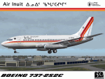
I am proud to present this repaint of Air Inuit's Boeing 737-2S2 combi, registration C-GAIG. Air Inuit is based in Dorval, Quebec, Canada. It is wholly owned by the people of Nunavik through the Makivik Corporation. This aircraft flies into and out of Montreal's Pierre Elliott Trudeau International Airport (CYUL) to various destinations throughout Quebec. This aircraft began its service as N204FE (now registered as a B722F) flying for Federal Express. It was delivered to FedEx in September of 1979, making it over 31 years old. For this as with all of the aircraft I paint, I paid attention to detail and realism as much as possible and generated this repaint with realistic but not overstated details. The textures in this repaint are 32-bit. This is a textures only package; you must have the Tinmouse 737-200adv v2 base package and updates available here at AVSIM to enjoy this repaint.
| Filename: | Air_Inuit_Boeing_B7372S2C_CGAIG.zip |
| License: | Freeware, limited distribution |
| Added: | 1st October 2010, 04:38:50 |
| Downloads: | 923 |
| Author: | Jeffrey S. Bryner, Tinmouse II Project |
| Size: | 7.91 MB |
| Category: Flight Simulator 2004 - AFCAD Files | |
| EGDL RAF Lyneham, England, UK |
|
Images related to this file:
File Description:
These AF2 files are based on the file from David Mackie's RAF Lyneham scenery. However, they are also fully compatible with the default. They have been modified with guidance from various aerial photographs (eg. Google Earth etc). I have tested them with and without the Justflight VFR photographic scenery, and all the main airfield features have been aligned accordingly. So whatever combination of scenery you have on your system, there is a suitable afcad for you included within this release.
It is FULLY compatible with the UK Military AI Project releases and many others eg. Ed Kooymans, MAIW etc. My motivation for this update was primarily to provide a better looking airfield for users of my Air Charter Express package, available from Avsim (extended search: author "Dan Foster", sort by release date). But given the lack of decent Lyneham AF2 files that can adequately handle the RAF Hercules component, I hope this release will appeal to a much wider base.
| Filename: | EGDL_RAF_Lyneham_England_UK.zip |
| License: | Freeware |
| Added: | 5th May 2010, 22:02:56 |
| Downloads: | 703 |
| Author: | Dan Foster |
| Size: | 320.72 KB |
| Category: Flight Simulator 2004 - AFCAD Files | |
| EBOS Oostende/Brugge International Airport, Ostend, Belgium (includes modified twy signs!) |
|
File Description:
These files are for the FS9 default. The "AF2_EBOS_DF.BGL" file is based on the Microsoft Virtual Earth aerial photography (via "Flash Earth"). It is an extensive modification of a file by Jean-Philippe Delwiche (merci Monsieur!). The "EBOS_twy_signs.BGL" file corrects the taxiway sign positions and content, and the exclude files prevent any default scenery from obstructing the airfield. Because I like the interesting variation and "East meets West" feel of the Oostende traffic, I like to pass through once in a while. Therefore, it is important to me that the layout is at least proportionally genuine, and a better reflection of reality than the default.
My thanks to Jean-Philippe Delwiche (aka JeePee) for his kind permission for my use of his work.
Also, thanks to Jan Martin for his guide to taxiway sign editing, which I hope I have used to good effect.
This release complements my Air Charter Express and MK Airlines flightplans well.
| Filename: | EBOS_OostendeBrugge_International_Airport_Ostend_B.zip |
| License: | Freeware |
| Added: | 11th May 2009, 01:06:04 |
| Downloads: | 725 |
| Author: | Dan Foster |
| Size: | 1.5 MB |
| Category: Flight Simulator X - Aircraft Repaints, Textures and Modifications | |
| FS2004/FSX Air Canada "rouge 2026" Boeing 737-8MAX |
|
Images related to this file:
File Description:

FS2004/FSX Air Canada "rouge 2026" Boeing 737-8MAX. Registration C-FTJV Fin#501 - The first MAX to move to Air Canada 'rouge' in 2026. Included are 2 versions of expected livery. Small decal "Operated by" by D1 and the anticipated "final" rouge livery with rouge by the front rondelle mirroring the "express" livery on the mainline black white on the TDS Boeing 737 MAX8 V3 paint kit. Air Canada's 737 MAX aircraft are being moved from its mainline operations to its subsidiary Rouge over the next few years. The 737 MAXs are expected to enhance Rouge's leisure competitiveness, including by allowing it to fly to new destinations. Textures only; you will need to add to your existing TDS 737 MAX8 V3 file or download the latest version from TDS. The model does not include a VC. The detailed textures include full night lighting and ground vehicles. Repaint by Phillip Hughes.
| Filename: | FS2004FSX_Air_Canada_rouge_2026_Boeing_7378MAX.zip |
| License: | Freeware |
| Added: | 1st March 2026, 13:37:44 |
| Downloads: | 108 |
| Author: | Phillip Hughes |
| Size: | 23.32 MB |
| Category: Flight Simulator 2004 - AI Aircraft | |
| Volaris Airbus A319 Fleet - Part 2 |
|
Images related to this file:
File Description:

FS2004 Volaris A319 Fleet Texture Pack (Part 2) that represents 11 out of 22 A319's current 2013 fleet.
All 22 volaris A319's are named and their respective names are quite notorious so it is difficult that
one single plane might be able to represent the whole fleet, therefore, this file contains a second
batch of 11 planes, including all the specially livered frames. XA-VOH "Carmen" Riviera Nayarit,
XA-VOI "Daniela", XA-VOJ "Javier", XA-VOK "Jessica" American Express, XA-VOL "Lia", XA-VOO
"Godofredo", XA-VOP "Francisco" Puebla, XA-VOQ "Quetzalli" Chicago, XA-VOR "Rebeca", XA-VOS
"Sandra" Ahora, tu decides que pagar and XA-VOT "Sergio". See the preview images. These texture
set is for the new FAIB A319 IAE Model (FAIBA319.zip) by Erez Werber. You will need the file
(FAIB_Volaris_A319_Fleet_1.zip) to complete the whole Volaris 2013 A319 fleet. Textures for
FSX come in a separate file not included within this file. Repaints by Bruno Koppel.
| Filename: | Volaris_Airbus_A319_Fleet__Part_2.zip |
| License: | Freeware |
| Added: | 12th September 2013, 22:20:56 |
| Downloads: | 1,037 |
| Author: | Bruno Koppel |
| Size: | 3.76 MB |
| Category: Flight Simulator 2004 - AI Aircraft | |
| Volaris Airbus A319 Fleet - Part 1 |
|
Images related to this file:
File Description:
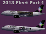
FS2004 Volaris A319 Fleet Texture Pack (Part 1) that represents 11 out of 22 A319's current 2013 fleet.
All 22 volaris A319's are named and their respective names are quite notorious so it is difficult that
one single plane might be able to represent the whole fleet, therefore, this file contains a first batch
of 11 planes, including all the specially livered frames. N501VL "Mirley", N502VL"Geraldine",
N503VL "Luis", N504VL "Lydiana", XA-VOA "Andrea" Volaris/Visa Credit Card, XA-VOB "Raul",
XA-VOC "Claudia" Colima Tiene Magia, XA-VOD "Daniel", XA-VOE "Ernesto" Jose Cuervo Express,
XA-VOF "Francisco" and XA-VOG "Gerardo". See the preview images. These texture set is for the
new FAIB A319 IAE Model (FAIBA319.zip) by Erez Werber. You will need the file
(FAIB_Volaris_A319_Fleet_2.zip) to complete the whole Volaris 2013 A319 fleet. Textures for
FSX come in an separate file not included within this file. Repaints by
Bruno Koppel.
| Filename: | Volaris_Airbus_A319_Fleet__Part_1.zip |
| License: | Freeware |
| Added: | 12th September 2013, 22:20:41 |
| Downloads: | 1,318 |
| Author: | Bruno Koppel |
| Size: | 3.92 MB |
| Category: Prepar3D V1-4 - Scenery | |
| KLVN - Airlake Airport - Lakeville, MN, USA |
|
File Description:
KLVN - Airlake Airport beta version .4 - by Jason Boche
This is an update of the default P3Dv4.5 KLVN airport. Aside from the original 12/30 runway, everything else at this airport has been completely ripped and replaced.
Enhancements include:
-Extended runway on each end to depict current configuration
-Accurate taxiways including Hamburg Ave. and buildings representing the current general aviation hangars
-Added navigational equipment on the field
-Added a few asphault and dirt service roads
-Added FBO and other buildings as close as I could match them
-Added some general aviation aircraft, civilians, vehicles at the FBO and hangars, and two fuel trucks
-Moved fuel station to where I believe it is currently according to Google maps with 100LL fuel trigger functional
-Moved the windsock to accurate location
-Moved the beacon to accurate location
-Moved GA parking spots
-Added trees around FBO and beacon
-Added utility poles
-Added a few square miles of Lakeville city, farm, and residential land class and autogen according to Google maps. This is probably the biggest improvement. It now looks like people live, work, and shop north/northwest of KLVN.
-Reworked the runway 12/30 blast pads to what I believe is the "proper" method. Instead of freehand polygon asphault, they are now actual runway extensions on both ends with yellow chevron markings
-Reworked the land class on the southwest end of the airport where I believe hangar expansion is intended. Prior to this, there was a sharp contrast between where the KLVN airport boundary ended and where generic farm landclass began which was right in the middle of the southwest taxiways and it looked bad. Now that whole region is grass and looks to be part of the airport parcel.
-Minor building adjustments west of the FBO to better match actual placement.
-Fixed a gap on the southeast end of Hamburg ave taxiway where it rounds the corner for the rwy 30 hold short line
-Randomized the directional facing of some of the cars parked at GA hangars
-Renumbered the parking spots 1-4 with #5 being the refueling spot
-Reversed the start direction of parking spots 1-3.
-Pulled the refueling parking "start" spot back because on start the engine cowling & prop were too far forward inside the fuel pump equipment
-Added an autogen exclusion to the rwy 12 short final due to trees popping up on short final path.
-KLVN tower viewpoint 25 meters above FBO.
-Removed the perimeter fence around the entire field
| Filename: | KLVN__Airlake_Airport__Lakeville_MN_USA.zip |
| License: | Freeware |
| Added: | 13th May 2020, 17:18:40 |
| Downloads: | 84 |
| Author: | Jason Boche |
| Size: | 14.81 KB |
| Category: Flight Simulator X - AFCAD Files | |
| KLVN - Airlake Airport - Lakeville, MN, USA |
|
File Description:
KLVN - Airlake Airport beta version .3 - by Jason Boche
This is an update of the default FSX KLVN airport. Aside from the original 12/30 runway, everything else at this airport has been completely ripped and replaced.
Enhancements include:
-Extended runway on each end to depict current configuration
-Accurate taxiways including Hamburg Ave. and buildings representing the current general aviation hangars
-Added navigational equipment on the field
-Added a few asphault and dirt service roads
-Added FBO and other buildings as close as I could match them
-Added some general aviation aircraft, civilians, vehicles at the FBO and hangars, and two fuel trucks
-Moved fuel station to where I believe it is currently according to Google maps with 100LL fuel trigger functional
-Moved the windsock to accurate location
-Moved the beacon to accurate location
-Moved GA parking spots
-Added trees around FBO and beacon
-Added utility poles
-Added a few square miles of Lakeville city, farm, and residential land class and autogen according to Google maps. This is probably the biggest improvement. It now looks like people live, work, and shop north/northwest of KLVN.
-Reworked the runway 12/30 blast pads to what I believe is the "proper" method. Instead of freehand polygon asphault, they are now actual runway extensions on both ends with yellow chevron markings
-Reworked the land class on the southwest end of the airport where I believe hangar expansion is intended. Prior to this, there was a sharp contrast between where the KLVN airport boundary ended and where generic farm landclass began which was right in the middle of the southwest taxiways and it looked bad. Now that whole region is grass and looks to be part of the airport parcel.
-Minor building adjustments west of the FBO to better match actual placement. Will only be shown on high scenery detail.
-Fixed a gap on the southeast end of Hamburg ave taxiway where it rounds the corner for the rwy 30 hold short line
-Randomized the directional facing of some of the cars parked at GA hangars
-Renumbered the parking spots 1-4 with #5 being the refueling spot
-Reversed the start direction of parking spots 1-3.
-Pulled the refueling parking "start" spot back because on start the engine cowling & prop were too far forward inside the fuel pump equipment
-Added an autogen exclusion to the rwy 12 short final due to trees popping up on short final path.
-KLVN tower viewpoint 25 meters above FBO.
-Removed the perimeter fence around the entire field
| Filename: | KLVN__Airlake_Airport__Lakeville_MN_USA.zip |
| License: | Freeware |
| Added: | 22nd November 2013, 23:26:10 |
| Downloads: | 225 |
| Author: | Jason Boche |
| Size: | 446.33 KB |
| Category: Flight Simulator 2004 - Scenery | |
| Backcountry airfields for 19m terrain mesh in Idaho USA |
|
Images related to this file:
File Description:
These four backcountry fields are for use with the FSGenesis 19m mesh of Idaho, and are Big Creek, Johnson Creek, Dixie, and Sulphur Creek Ranch. They have been revised to fit and almost certainly do not work without the 19m mesh; a quick comparison with Big Creek before and after demonstrates the difference. I also have Ultimate Terrain installed. The three ingredients of terrain mesh, UT main roads, and UT streams, along with their individual margins of error, very often create conficts of space that make a grass runway impossible to site with it's correct length. Given the choice of turning off roads or streams (the terrain mesh cannot be turned off, obviously) I chose streams; the roads are less obviously incorrect, plus it matters not if roads go uphill while a climbing stream is to be avoided. On that basis the original series is reissued here for use with the 19m terrain mesh, on the presumption that you have already downloaded the original series. There are no textures or AI included as they remain the same as the originals, and the new scenery bgl's replace the originals to get the runways and grass etc in the right positions. There will be follow-on fields that are new, and all of the new ones will be only for the 19m mesh.
| Filename: | Backcountry_airfields_for_19m_terrain_mesh_in_Idah.zip |
| License: | Freeware, limited distribution |
| Added: | 29th May 2017, 04:19:43 |
| Downloads: | 124 |
| Author: | Roger Wensley |
| Size: | 2.22 MB |
| Category: Flight Simulator X - Scenery | |
| Columbia SC (KCAE) |
|
Images related to this file:
File Description:
The Columbia Metropolitan Airport Authority has provided substantial information about KCAE online, making it possible to pretty accurately model this airport. The taxiway signs have been placed according to exhibits in the airport's certification manual, and taxiway designations have been revised in accordance with upgrades to be effective mid-Novemer 2012. Most buildings have been custom modeled in accordance with information available on the internet, including Microsoft Bing birdseye views. The airport layout and landclass changes are in accordance with Google Earth imagery.
If you have Jim Dhaenens' lightobj.bgl installed, apron lighting will be included, and if you have
KB_static_aircraft_FSX installed (available at www.kb-sim.com/screens_static_aircraft.html),
additional parked aircraft will be visible. The layout of scenery is optimized for use with
Ultimate Terrain X-USA. FSX runs smoothly with this scenery on my computer, but it has not been
tested on a low-end system. Sometime after starting this project, it came to my attention that a
good scenery for KCAE was already available (but not listed at www.freewarescenery.com) from Jim
Hill that is another option as well as adjusting scenery complexity.
The new taxiway designations are not yet shown in the latest observed FAA airport diagram. An airfield sketch provided to pilots by the Columbia Metropolitan Airport is included in the package to show the taxiway designation changes.
| Filename: | Columbia_SC_KCAE.zip |
| License: | Freeware |
| Added: | 14th December 2012, 01:28:23 |
| Downloads: | 1,694 |
| Author: | Art Poole |
| Size: | 3.43 MB |


© 2001-2026 AVSIM Online
All Rights Reserved
Privacy Policy |