
Where Flight Simulation Enthusiasts Gather from Around the World!
AVSIM Library - Search Results

| Category: Flight Simulator 2004 - Scenery | |
| Graskop Airfield, South Africa |

|
Images related to this file:
File Description:
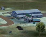
Graskop Airfield does not appear in the default FS2004, neither is the town included which is a pity as the airfield lies right on the edge of a gorge where bungee jumping and even a Gorge-lift (elevator) or a slide across the gorge can be enjoyed by the adrenaline junkies. Added to this, the airfield (and town of Graskop) is merely 10km from the world famous God's Window (also featured in the film, "The Gods must be Crazy").
This package will add a custom (Gmax & Sketchup) made Graskop Airfield, Mpumalanga, South Africa with photoreal textures and ground textures. The included Landclass file will also add the town.
The small airfield has been recreated with custom true to life models and photoreal textures. While being a very small airfield with only one hangar and a large antenna tower, the importance of the airfield far outweighs its size. The airfield plays a vital role in the fight against wildfires as there are water bombers based at the airfield during critical times. In real life the runway is quite challenging, being sloped quite significantly and very narrow, with a one-way-in one-way-out landing and takeoff procedure. Due to the limits within flightsim, the slope could not be replicated but all the other challenges are there.
The asphalt runway is aligned 15/33 and only 800m long by 8.5m wide and sits at an elevation of 4 854ft.
| Filename: | Graskop_Airfield_South_Africa.zip |
| License: | Freeware, limited distribution |
| Added: | 3rd September 2021, 00:55:30 |
| Downloads: | 160 |
| Author: | Kobus van Wyk & Morne van Wyk |
| Size: | 4.13 MB |
| Category: Flight Simulator 2004 - Scenery | |
| Lanseria International Airport (FALA), Johannesburg, South Africa |
|
Images related to this file:
File Description:
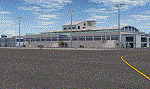
Lanseria international airport is Johannesburg's second international airport and mostly cater to private jets, low cost airlines and many private general aviation and flightschool aircraft. It is a privately owned airport and can accomodate aircraft up to the size of a Boeing 757-300. This airport has seen John Travolta use it with his Boeing 707, the Hilton family with a private Boeing 757 and even the USAF have landed their C-17 Globemasters at the airport when Air Force one came here in the past with the latter landing at AFB Waterkloof.
This package started out as a conversion of the wonderfull FSX scenery of the airport by Lee Hall and converted with permission from the original author. It quickly expanded however to a project that now additionally includes photoreal ground textures that changes with seasons, many added fences and gates around the airport, inclusion of the shaded parking areas with parked cars, static airplanes (RWY12 and EZ scenery libraries needed to see this) as well as numerous objects around the airport and apron made by myself in Gmax to give the airport some FS9 life.
Also included is the wonderfull "apron light splashes" by Hans Günther Schnell who kindly gave me permission to use it for the night times.
I have also included a local mesh for the area for users of FSGlobal 2010 to eliminate the extreme elevation anomoly around the airport.
| Filename: | Lanseria_International_Airport_FALA_Johannesburg_S.zip |
| License: | Freeware, limited distribution |
| Added: | 11th August 2023, 16:03:37 |
| Downloads: | 273 |
| Author: | Kobus van Wyk, Lee Hall |
| Size: | 37.64 MB |
| Category: Prepar3D V1-4 - Aircraft Repaints, Textures and Modifications | |
| Douglas C-47 (X-1) Dutch Air Force |
|
Images related to this file:
File Description:
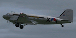
This folder contains a repaint for P3Dv4.5 PBR version of the Douglas C-47 by Manfred Jahn and colleagues in the colors of X-1 of the Dutch Air Force. The Dutch Air Force received her first Dakota's in 1952, although they owned one in 1946, but that crashed near Katwijk the same year and was destroyed. That one carried the registration X-1, but that is not the subject of my paint... The Air Force later leased one C-47 from the KLM, gave it the military registration X-2, but it kept its civil registration, PH-TBV, on the tail. Later they leased a few more, and clearly they liked them, because they bought a few more in 1952. The first one was taken on charge in 1952 and was numbered X-1 as depicted in this repaint. The makers badge with its construction number was missing however, and nobody seems to know where this aircraft came from. The logbook mentions the aircraft was 'found'. There was a rumour that the aircraft had been used by refugees from the east and landed at Valkenburg airfield without registration. About a year later, the aircraft made an emergency landing near Valkenburg after taking off for a relief flight for the flooded areas in the south of the Netherlands on 6 februari 1953 and was written off. Repaint by Jan Kees Blom for Manfred Jahn's C-47 for P3Dv4.5, with PBR, Rivet and bump detail by Ted (Tufun) Wolfgang."
| Filename: | Douglas_C47_X1_Dutch_Air_Force.zip |
| License: | Freeware |
| Added: | 26th January 2020, 17:55:48 |
| Downloads: | 152 |
| Author: | Jan Kees Blom |
| Size: | 25.1 MB |
| Category: Flight Simulator X - Scenery | |
| RNAS Anthorn (HMS Nuthatch) - Cumbria, UK |
|
File Description:
This scenery is a representation of RNAS Anthorn (HMS Nuthatch) prior to runway and taxiway upgrades completed in 1948. It is not 100% accurate and no claim is being made that it is.
The scenery was made using ADE and is intended for use in FSX along with Horizon GenX VFR scenery but should work ok in Basic FSX.
Some History: Anthorn air field (also known as RAF Anthorn, RNAS Anthorn and HMS Nuthatch) was an airfield approximately 430 KM north-northwest of London
The airfield was built in february 1918 as a Fleet Air Arm (FAA) airfield. It was abandoned after World War I ended, however. The RAF reinstated the airfield at the beginning of World War II as an emergency landing ground for nearby RAF Silloth.
The site was taken over by the Royal Navy in December 1942, and renamed the site RNAS Anthorn. It was commissioned in September 1944 as 'HMS Nuthatch'.
The airfield served as No. ARDU (Aircraft Receipt and Dispatch Unit), a unit that accepts aircraft from their manufacturers and prepares them for operational use.
The last official flight took off from the airfield in November 1957. It was then put on Care and Maintenance, before it closed down in March 1958.
In 1961 the site was chosen to become a NATO VLF transmitting site for communicating with submarines. Construction of the site, by Continental Electronics of Dallas, U.S.A., began in 1962.
The station was accepted on behalf of the MoD in November 1964.
| Filename: | RNAS_Anthorn_HMS_Nuthatch__Cumbria_UK.zip |
| License: | Freeware |
| Added: | 1st March 2015, 23:11:58 |
| Downloads: | 435 |
| Author: | Mark Byers |
| Size: | 21.34 MB |
| Category: Flight Simulator X - Scenery | |
| YKLN Kulin Town and YJLN Kulin, Jilakin Rock, Western Australia |
|
File Description:
YKLN Kulin Town and YJLN Kulin, Jilakin Rock. Kulin is located in the upper great southern Wheatbelt of Western Australia, the Shire of Kulin covers an area of 4,790 square kilometres. It encompasses the towns of Kulin, Pingaring, Dudinin, Jitarning, and Holt Rock. The Kulin economy is based on agriculture and was settled by pastoralists in 1905. The crosswind runway is actually 7 miles to the east at Jilakin Rock and slopes uphill to the east. For convenience, I have used fictitious YJLN. Jilakin Downs is a Dorper sheep stud farm and the home of the Kulin Bush Races. Dorpers are currently under a cloud in Western Australia as the local abatoirs claim their hair is contaminating the meat and won't accept them. "We welcome air traffic to our 2012 Kulin Bush Races Weekend. A crosswind airstrip is available, with a shuttle bus service to the Jilakin Track. GPS position is S32-39-95 E118-18-71 and the elevation is 950 feet. The strip is 7 nautical miles east of the town of Kulin. Camping and toilets are close to the strip so that you can camp near your plane.
Kulin airstrip is also available for landing and takeoff during the weekend, a shuttle bus is available to take you out to the race track. If this option is chosen please contact Barry West. Please contact Barry West for flying information on 9880 9021" www.kulin.wa.gov.au/tourism_and_local_events/kulin_bush_races/flying_visit.html REQUIRES Blencowe_LibraryKit.zip
REQUIRES blencowe_librarykit_309494.zip (Available HERE)
| Filename: | YKLN_Kulin_Town_and_YJLN_Kulin_Jilakin_Rock_Wester.zip |
| License: | Freeware |
| Added: | 28th February 2013, 13:52:31 |
| Downloads: | 225 |
| Author: | Alan Blencowe |
| Size: | 5.73 MB |
| Category: Flight Simulator 2004 - Flight Plans | |
| Military Base Tour - Pacific Rim |
|
File Description:
Military Base Tour – Pacific Rim (MFPR) contains 21 Flight Plans (.PLN) for flights to various military air bases along the Pacific Rim, across the Pacific to CONUS and ending at Andrews AFB/NAF where the Military Flights Series began. It is the continuation of Military Flight Plans (MF) (mf_flights.zip) published in Avsim on 29th March 2004, Military Flight Plans – Europe (MFE) (mfe_flights.zip) published in Avsim on 17th June 2004 and Military Base Tour – West Asia (MFWA) (mfwa_flights.zip) published in Avsim on 6th August 2004 and Military Base Tour – South Asia (MFSA) (mfsa_flights.zip) published in Avsim on 20th November 2004. There are a total of 128 flight plans in this Military Flight Series - Round the World Tour of Military Bases. (See Military Flights Master Itinerary– included in this .zip.) The itinerary contains a list of all the plans in the five uploaded files.) There are Briefing documents for each flight in Microsoft Word (.doc) and Text (.txt). The Flight Plans use the autopilot from takeoff to landing. The speed, altitude, weather, radios and various other controls are the pilot’s responsibility. Many landings are IFR and all are under the control of the autopilot. It is suggested that the pilot set up a separate Folder (“MFPR Flights” for example) and unzip this file there to store the .PLN and Briefing files. The .PLN can then be copied to the “Flight Simulator Files” and used to set up the flight and the Briefings printed and available for quick reference during the flight.
| Filename: | Military_Base_Tour__Pacific_Rim.zip |
| License: | Freeware |
| Added: | 9th April 2005, 04:39:05 |
| Downloads: | 1,382 |
| Author: | John Resch |
| Size: | 282.22 KB |
| Category: Flight Simulator 2004 - Scenery | |
| Allakaket 6A8 Runway and Taxiway Lighting in Alaska |
|
Images related to this file:
File Description:
Allakaket is on the Koyukuk River in Alaska, 40 miles southwest of Bettles. This posting adds proper runway and taxiway lighting to the scenery, as shown in the screenshots. There will be lights on top of traffic cones visible during the day, just as there are at Allakaket in real life so that pilots can still see them after a snowfall. At night there will be lit lights that properly illuminate the runway for landing, and at a lower level of brightness the taxiway. Put the bgl's into the existing scenery folder of your Allakaket 6A8 installation and say yes to replace the existing bgl's that have the same names. Add the texture bmp's to the texture folder. That's all, and in fact you could try it without the textures in the Allakaket 6A8 texture folder, but read on. Instal the Library objects once and for all by placing the CONTENTS of the Lighting Library scenery folder in your static objects scenery folder and the CONTENTS of the texture folder in the static objects texture folder (which is how I install scenery objects libraries). Alternatively, put them in the scenery and texture folders of your Add on scenery folder, or even in the main scenery and texture folders. They just have to be in related scenery and texture folders that are always active when FS9 is running. There will be further retro upgrades to other recent scenery that was posted with temporary lighting. Say thank you to Greg Putz for making the lighting.
| Filename: | Allakaket_6A8_Runway_and_Taxiway_Lighting_in_Alask.zip |
| License: | Freeware, limited distribution |
| Added: | 23rd November 2019, 20:30:02 |
| Downloads: | 116 |
| Author: | Roger Wensley |
| Size: | 711.35 KB |
| Category: Flight Simulator 2004 - Original Aircraft | |
| Worship International Boeing 777-200LR, Complete Fleet |
|
File Description:
FS2004 Worship International Boeing 777-200LR,
Complete fleet, aircraft and textures!!!
Includes unzipped "mj72l2ge.zip".
UNZIP to your aircraft folder!!! That's all there is to it.
Includes E Gomide Charters PLUS 3 versions of our personal Worship fleet of this aircraft. (Also works in FS2002).
Features animated reclining seats, animated stowable PTVs and tray tables, and animated footrests. The virtual cabin has been extended with the addition of first and economy classes. "Maintenance mode" has also been expanded, with the addition of opening doors. Minor additions in the way of detail have also been made to the model. This rendition of the 777 has been built in Gmax for FS2002 (works perfect in FS2004) and features a 32-sided fuselage and engines; "maintenance mode" featuring opening engine cases, deployable Ram Air Turbine, opening gear bay doors on ground, opening captain's window; virtual cabin (business class); flexing wings; dynamic wing views; animated reversers with animated fan air blocker doors; see through engines; animated landing gear with fully modeled struts and hydraulic pistons, also featuring animated flexible gear hoses; animated flaps, slats, ailerons, elevators and spoilers with animated hydraulic pistons; advanced logic nose gear add main gear steering; animated primary and secondary rudder; dynamic shine and reflective surfaces; 3D APU; 3D gear, flap, slat bays; seamless wing root fairing; dimensioned to high accuracy; accurate flight dynamics; extremely detailed all round. By Melvin Rafi (MelJet). 4 Paint schmes included.
Repaint by jimmy R martin using "FS Repaint by Abacus & Paint Shop Pro 7.04." Range over 10,000 miles!!!
| Filename: | Worship_International_Boeing_777200LR_Complete_Fle.zip |
| License: | Freeware |
| Added: | 29th September 2003, 14:31:01 |
| Downloads: | 27,902 |
| Author: | jimmy R martin |
| Size: | 9.28 MB |
| Category: Flight Simulator X - AFCAD Files | |
| Vineland-Downstown Airport (28N), NJ |
|
File Description:
Located 04 miles NE of Vineland, New Jersey on 45 acres of land, Vineland-Downstown Airport is a turf field that mainly services crop dusting operations for the surrounding farms. It also can serve firefighting aircraft - in fact the second runway (12/30) is specifically for that purpose along with agricultural use. This airport as modeled in FSX is kind of inbetween the current layout and the past layout. Based on various images both satellite and other, it seems 28N has undergone some serious expansion since the MSE textures were created. A large paved area to the west of the airport has been built and has parking aprons for up to around 25 aircraft. If you use an add-on traffic program you might want to think about reconfiguring it to assign more flights to this airport because it can certainly handle them now. You can fuel up in your plane by stopping near the fuel tank on the north end of the west tarmac or in your helicopter by landing on the concrete patch north of the runway.
Scenery constructed with use of satellite images/streetview, the author has not been there in person.
This scenery is meant to be used in conjunction with MegaScenery Earth New Jersey/Delaware 004. It is not required, but apron use is minimized to allow satellite scenery to show through as much as possible, and objects are placed based on the MSE textures - lack of it may make scenery look out of place.
| Filename: | VinelandDownstown_Airport_28N_NJ.zip |
| License: | Freeware |
| Added: | 11th October 2010, 06:13:42 |
| Downloads: | 206 |
| Author: | Drew Sikora |
| Size: | 324.96 KB |
| Category: Flight Simulator X - AFCAD Files | |
| Salem Airfield Airport (NJ74), NJ |
|
File Description:
Located 01 miles E of Salem, New Jersey on 14 acres of land, Salem Airfield is a private turf strip 2200' in length. The hard surface runway has been removed so have your mesh settings as high as possible to get the most out of landing/taking off on actual terrain. The surrounding area has been highly detailed with as much forestation as possible included to block out the horizon as much as possible considering the many open spaces surrounding the airport. Tie downs are located next to the middle of the runway, look for the marker cones or start in any RAMP_GA_SMALL parking locations. A hangar is available as well, and attendant is on call on NAV2 to open the door. You can start inside the hangar in the DOCK_GA parking spot or outside the hangar in the RAMP_GA parking spot. All parking is for aircraft with wingspans no greater than 40 feet. There is no fuel available. The field is lit for night use, but the windsock is not so check your weather before flying in!
Scenery constructed with use of satellite images/streetview/aerial photos - the author has not been there in person.
This scenery is meant to be used in conjunction with MegaScenery Earth New Jersey/Delaware 004. It is not required, but apron use is minimized to allow satellite scenery to show through as much as possible, and objects are placed based on the MSE textures - lack of it may make scenery look out of place.
| Filename: | Salem_Airfield_Airport_NJ74_NJ.zip |
| License: | Freeware |
| Added: | 10th August 2011, 02:05:51 |
| Downloads: | 176 |
| Author: | Drew Sikora |
| Size: | 910.96 KB |
© 2001-2026 AVSIM Online
All Rights Reserved
Privacy Policy |