
Where Flight Simulation Enthusiasts Gather from Around the World!
AVSIM Library - Search Results

| Category: Flight Simulator 2004 - Scenery | |
| Deline CYWJ - Northwest Territories, Canada |

|
Images related to this file:
File Description:
This is the third in a series of airfields that follow in a southward direction that early access route to the Canadian northern shore, the Mackenzie River. Deline is south of Tuktuk, Inuvik, Fort McPherson, and Fort Good Hope, all already posted. Deline is at 704 feet asl and around 50 miles east of the the Mackenzie, where the Great Bear River flows out of the western end of Great Bear Lake on its way to the Mackenzie. This lake is huge. The town of Deline has a population of around 500, and the first trading post (of the North West Company) was established there as early as 1799. The Hudson Bay Company opened an outpost in 1825 to support the Franklin Arctic Exploration expedition, and it was then called Fort Franklin. The name was changed to Deline in 1993. The airport is just over a mile north of the town, and has almost 4,000 feet of gravel runway. There is no fuel available. The original airfield is still visible just to the north of the town, from before it was rebuilt on higher ground (better drainage) and away from the houses. AI will follow with later posts.
| Filename: | Deline_CYWJ__Northwest_Territories_Canada.zip |
| License: | Freeware, limited distribution |
| Added: | 5th July 2014, 14:47:36 |
| Downloads: | 241 |
| Author: | Roger Wensley |
| Size: | 2.54 MB |
| Category: Flight Simulator 2004 - Scenery | |
| CZFN - Tulita - Northwest Territories, Canada |
|
Images related to this file:
File Description:
Tulita (Fort Norman until 1996) is another in the series of airfields that follow (approximately) the Mackenzie River. At the far northern end of the river and on the eastern side of the delta there is Tuktoyaktuk, then Inuvik, Fort McPherson, Fort Good Hope, Deline, Wrigley, Fort Simpson Island and Fort Simpson, and then Fort Liard at the southern end of the list of those in the Northwest Territories. South of Fort Liard there are Peace River and Dawson Creek, both of which are already posted. Tulita is at the junction of the Mackenzie and Great Bear Rivers, on the east bank of the Mackenzie and the south bank of the Great Bear, around 40 miles southeast of Norman Wells. The town has a population of about 480 folks. The airport is above and to the east of the town, and has 3,000 feet of gravel runway. The scheduled flights are by North Wright and I have also added a Buffalo DC3 and GA. There is a mandatory radio frequency but in this case I have set the "tower" to "unmanned" so you will report position and intentions. There is no fuel available.
| Filename: | CZFN__Tulita__Northwest_Territories_Canada.zip |
| License: | Freeware, limited distribution |
| Added: | 12th July 2014, 08:05:54 |
| Downloads: | 272 |
| Author: | Roger Wensley |
| Size: | 2.66 MB |
| Category: Flight Simulator 2004 - Scenery | |
| Wrigley CYWY - Northwest Territories, Canada |
|
Images related to this file:
File Description:
Wrigley is the next in a series of airfields that follow (approximately) in a southward direction that early access route to the Canadian northern shore, the Mackenzie River. At the far northern end there is Tuktoyaktuk, then Inuvik, Fort McPherson, Fort Good Hope, and Deline, all posted. Wrigley is at 489 feet asl and on the east bank of the the Mackenzie, around 135 miles due south of Deline. The town of Wrigley has a population of only 125 or so folks, and was relocated to its current position in 1965 from Fort Wrigley to be near the WW2 era airfield; I have no idea where Fort Wrigley is, or was. The airport is just over a mile south of the town, and has 3,500 feet of gravel runway. North Wright Air have scheduled flights to here and other airfields up and down the Mackenzie (including Deline, Fort Simpson, and Fort Good Hope etc) which is reflected in the revised AI. There is again a mandatory radio frequency but I have set the "tower" as unmanned so you will announce intentions and join downwind. There is no fuel available.
| Filename: | Wrigley_CYWY__Northwest_Territories_Canada.zip |
| License: | Freeware, limited distribution |
| Added: | 5th July 2014, 21:01:37 |
| Downloads: | 212 |
| Author: | Roger Wensley |
| Size: | 3.81 MB |
| Category: Flight Simulator 2004 - Panels | |
| Generic Customized Advanced Panels |
|
File Description:
FS2004 Generic Advanced Customized Panels. Since this panel includes All XML gauges for 2-, 3- and 4 Jet engines aircrafts, Concorde and Warplains for 1 and 2 Engines, including landing panel. Special effects of the visor in the mainpanel of the Concorde. It can be used for any heavy jet. Also you have 3 choices, between the metal gray color panel (old Boeing) or the brown color of the FS2004 boeing default and the feeling to be in a Airbus (PFD of A380). All gauges are on the same place in the different engine version or airplane, no more memorizing the different panels. It has a full working overhead, TCAS radar, ATC control, customized FS2004 GPS, ACS-GPS, APU, FMC, HUD, Wiper and many custom xml gauges. Special attention is made on the Radio, Fuel, PFD, Clock, Taxi speed control, Wind speed, Bank rate, Auto mb-Hg, Push back,and Sim speed. A lot of information during take off, flight and landing. Many warnings included. Ideal panel for beginners and advanced simmers. Special Credit of gauges to Acsoft, Arne Bartels, Eric Mariano, Björn Karlsson, Tony d'Ambrosi, Nick Pike, etc. Panel design and gauges by Guy de Smet.
| Filename: | Generic_Customized_Advanced_Panels.zip |
| License: | Freeware |
| Added: | 16th January 2004, 23:00:39 |
| Downloads: | 16,068 |
| Author: | Guy De Smet |
| Size: | 10.3 MB |
| Category: Flight Simulator 2004 - Scenery | |
| Port McNeill CAM8 float base in British Columbia, Canada |
|
Images related to this file:
File Description:
This is the seventh in a series of new and renovated float bases in BC. Port McNeill is a float base in a sheltered inlet on the northeast coast of Vancouver Island, close to the town and just under 20 miles east of the Port Hardy float base. There is no fuel available as the Port Hardy floatbase (already posted) acts as a refuelling centre for this and other float bases in the neighbourhood. The dock is to the west of the marina and east of the log raft area. The AI is a further adaptation of the CF36 AI and involves Beavers as listed in the AI folder. At Port McNeill all the AI works for both landing and takeoff for all of the planes, no matter what the wind direction is. All of these float bases can be installed together in the same folders, with a saving in duplicate textures. So a series called BC Floats (or whatever you want to call it) or individually installed float bases; your choice. The next in the series was suposed to be Sullivan Bay, another floating marina, but I digressed to Port Hardy and Port McNeill.
| Filename: | Port_McNeill_CAM8_float_base_in_British_Columbia_C.zip |
| License: | Freeware, limited distribution |
| Added: | 21st January 2017, 19:11:03 |
| Downloads: | 171 |
| Author: | Roger Wensley |
| Size: | 5.07 MB |
| Category: Flight Simulator X - Gauges | |
| Advanced Radar System 4 (ARS4) |
|
Images related to this file:
File Description:
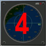
This gauge has been developed for FSX Flight Simulator SP1 or SP2. It
has also been tested with Microsoft Acceleration also, but compatibility is not guaranteed by the author.
This new Advanced Radar System (ARS 4) includes significant new features,
functions and displays for FSX AI traffic. The new key features are:
1)AI traffic display for air targets and boat/ship targets.
2)Auto landing on carrier if the carrier is part of the scenery MECOPS.
3)Allows switching between air target display and boat target display.
4) Provides for air and boat display to optionally insert airport and/or basic terrain display on the screen.
5)Different screen presentations for air and boat targets.
6)Simplified installation procedure.
7)The A2A re-fuel function remains the same as in the ARS2 version.
8)The auto tracking function remains the same as well as in the ARS2 version.
All displays for air, or boat/ship traffic, can be selected in a range of 5, 10, 20, and 40 miles.
For installation and additional information look at the ARS4 documentation inside the zip file. For copyrights and credits please look at the documentation for this gauge.
| Filename: | Advanced_Radar_System_4__ARS4.zip |
| License: | Freeware |
| Added: | 5th March 2013, 15:53:52 |
| Downloads: | 3,810 |
| Author: | Dietmar Loleit |
| Size: | 1.18 MB |
| Category: Flight Simulator 2004 - Original Aircraft | |
| Mitsubishi F-2A (Beta Model, Version 2) |
|
Images related to this file:
File Description:

F-2A is a Japanese fighter aircraft and it has been developed with the United States based on the General Dynamics (post 1993, Lockheed Martin) F-16 Fighting Falcon. Its blue oceanic flight livery is referred to as "The most beautiful camouflage livery of the world". Its three divited canopy and big-wide wing is the most different part between the F-2 and F-16. This model is only for FS9, you can't use it with FSX. By Team FS KBT.
The Mitsubishi F-2 Fighter is manufactured by Mitsubishi Heavy Industries (MHI) and Lockheed Martin for the Japan Air Self-Defense Force, with a 60/40 split in manufacturing between Japan and the USA.
Some differences between the F-2 and the F-16A:
* a 25% larger wing area
* composite materials used to reduce overall weight and radar signature
* longer and wider nose to accommodate a phased-array radar
* larger tailplane
* larger air intake
* three-piece cockpit canopy
* capabilities for four ASM-1 or ASM-2 anti-ship missiles, four AAMs, and additional fuel tanks
| Filename: | Mitsubishi_F2A_Beta_Model_Version_2.zip |
| License: | Freeware |
| Added: | 3rd June 2010, 12:09:35 |
| Downloads: | 12,343 |
| Author: | Team FS KBT: Daisuke Yamamoto, Hiroaki Kubota, Shingo Katsumata with Friends |
| Size: | 72.93 MB |
| Category: Flight Simulator 2004 - Scenery | |
| Embrun CPR2 in Ontario Canada 2012 Revision |
|
Images related to this file:
File Description:
Embrun is in Ontario a few miles southeast of Ottawa, and southwest of my posted strips Russel Farm, Russellet Strip, and Indian Creek. It is a real airfield, used by Embrun Flying Club, and there is now fuel since the owner built a house on the field and moved in, and more hangars than there used to be. All in all a nice airfield with a grass runway 2,260 feet long, and in this REVISED version with a new windsock. There are electric cables strung along the road at the eastern end of the runway, marked by visibility balls; watch out for those. At the western end there are some old grain silos; these shouldn't be a problem, and if you are flying a taildragger give you something to aim at until the tail comes up. I did my first grass field landing and take off there when I was learning to fly, and it is just the right distance from Rockcliffe for a nice afternoon training flight. Look out for geese taking off from the fields to the west when you use 26; that departure from Embrun along with 50 geese was more entertaining than most.
| Filename: | Embrun_CPR2_in_Ontario_Canada_2012_Revision.zip |
| License: | Freeware, limited distribution |
| Added: | 9th February 2012, 01:31:31 |
| Downloads: | 303 |
| Author: | Roger Wensley |
| Size: | 3.8 MB |
| Category: Flight Simulator 2004 - Scenery | |
| CEN5 - Cold Lake Regional & revised CYOD - Cold Lake, Alberta, Canada |
|
Images related to this file:
File Description:
CYOD was made by John Stinstrom and you should download and install it first; there is also a "fix" for the apron lights textures. I am posting a modified AFCAD for CYOD with John's knowledge; this changes gates and atc identifications for the gates, so that with my version of the CYOD AI there are pairs of F18s taking off every 20 minutes or so. This means that the nearby Cold Lake Regional CEN5 works within the busy environment of flights to and from the nearby base. There is also a Hawker Hunter that drops in, and transport planes. The planes are listed so that you will know which are required to be downloaded. CEN5 may have "Regional" attached to its name, but there are now no scheduled flights and it is a peaceful and relaxed little airfield. There is fuel, and a little clubhouse building, and some hangars. There is ai for it here, using original FS9 planes so no downloads are required. Right hand circuits for runway 25 to stay as far away as possible from CYOD, and it is the CYOD tower that controls all flights in the area.
| Filename: | CEN5__Cold_Lake_Regional___revised_CYOD__Cold_Lake.zip |
| License: | Freeware, limited distribution |
| Added: | 11th May 2014, 13:41:51 |
| Downloads: | 487 |
| Author: | Roger Wensley |
| Size: | 12.25 MB |
| Category: Flight Simulator 2004 - Scenery | |
| Durban Island CWFB FOX-E DEW line station in Nunavut, Canada |
|
Images related to this file:
File Description:
Durban Island is 40 miles north of Cape Dyer on the southeast corner of Baffin Island, and around 60 miles southeast of Qikiqtarjuaq (known as Broughton until recently). Sitting on the top of the island is FOX-E, an intermediate station that was part of the DEW line. There is no runway (and once you have seen the island you will know why) and the station and its (usually) five man crew were supported by helicopter flights from Cape Dyer. The main feature is a 300' high mast, topped by comms gear to link both to Broughton to the north and Cape Dyer to the south. There was only one really habitable building, 80' x 30' in round figures, and this contained the generators, technical spaces, sleeping areas, kitchen, mess, and showers etc. There were also what were known as Anderson shelters, originally put up to house the construction crew and used in the summer for any maintenance people who visited for short periods. There was also a garage for a snow cat and tanks for fuel. And a view.
This post also includes new bgls for Cape Dyer to provide the 300' tower there too.
| Filename: | Durban_Island_CWFB_FOXE_DEW_line_station_in_Nunavu.zip |
| License: | Freeware, limited distribution |
| Added: | 1st July 2011, 22:11:33 |
| Downloads: | 315 |
| Author: | Roger Wensley |
| Size: | 1.87 MB |


© 2001-2026 AVSIM Online
All Rights Reserved
Privacy Policy |