
Where Flight Simulation Enthusiasts Gather from Around the World!
AVSIM Library - Search Results

| Category: Flight Simulator 2004 - Scenery | |
| Ragusa, Sicily, Italy, Photo Real |

|
Images related to this file:
File Description:
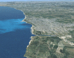
The photoreal scenery covers a great area of Sicily around the city of Ragusa. The Photo Real Scenery is wide for around 3200 squared Kms. The airport of Catania Sigonella (ICAO code LICZ) is found near to the scenery (see map). Otherwise the airport of Catania Fontanarossa (ICAO code LICC) can be used.
| Filename: | Ragusa_Sicily_Italy_Photo_Real.zip |
| License: | Freeware |
| Added: | 31st May 2010, 17:42:22 |
| Downloads: | 8,533 |
| Author: | Fulvio Mazzokan |
| Size: | 96 MB |
| Category: Flight Simulator 2004 - Scenery | |
| Exuma Intl, Bahamas MYEF |
|
File Description:
Scenery, Exuma Intl, Bahamas MYEF
Terminal and sign by Jorge Christian Pagano
Scenery created from airport photos and
includes VOR with improved lighting for approach.
ILS also included from FS2002. Map, GPS &
flight planner. Ships, boats, birds also.
"As real as I could get it."
New night palms by JCP for 2004
| Filename: | Exuma_Intl_Bahamas_MYEF.zip |
| License: | Freeware |
| Added: | 23rd August 2003, 15:37:18 |
| Downloads: | 5,940 |
| Author: | jimmy R martin |
| Size: | 1.96 MB |
| Category: Flight Simulator X - Gauges | |
| Bombardier CRJ-700 Gauge Fixes and Improvements |
|
File Description:
This package fixes numerous bugs in the gauges of the default Bombardier CRJ-700 and adds some new features.
Highlights:
New min/max speed bar in ASI, added wind vector to PFD, added track line in MFD,
added VORs and Airports in MFD map mode, new mouse click spots in PFD and MFD.
| Filename: | Bombardier_CRJ700_Gauge_Fixes_and_Improvements.zip |
| License: | Check within download |
| Added: | 31st March 2007, 13:35:52 |
| Downloads: | 7,900 |
| Author: | Alexander Barthel |
| Size: | 2.75 MB |
| Category: Flight Simulator 2004 - AI Aircraft | |
| Australian Douglas DC3s |
|
File Description:
This package is intended to give an AI representation of eight of the remaining airworthy DC3s in Australia. The CalClassics AI DC3 is used as the basis and the model is included here with Tom Gibson's very kind permission. Also included are fictitious flightplans based, where possible, on information from the operator's websites.
Aircraft represented are: VH-ABR - Ansett; VH-AES - TAA; VH-EAF - Historical Aircraft Restoration Society; VH-CWS - Classic Wings; VH-MMA - Hardy Aviation; VH-OVM - Shortstop Jet Charter; VH-SBL - Dakota National Air; VH-TMQ - Air Nostalgia
| Filename: | Australian_Douglas_DC3s.zip |
| License: | Freeware, limited distribution |
| Added: | 7th May 2008, 08:31:24 |
| Downloads: | 1,045 |
| Author: | CalClassic/Mal Lloyd |
| Size: | 5.26 MB |
| Category: Prepar3D V1-4 - Utilities | |
| Passenger Information Display |
|
Images related to this file:
File Description:

Hi all, i created a simple HTML script to output the SimtoolkitPro overlay data to any remote pc resulting in a passenger information system. It consists of 2 local html pages, 1 with current aircraft telemetry and 1 with the route map.
They cycle every 60 seconds but this is adjustable to your own taste.
| Filename: | Passenger_Information_Display.zip |
| License: | Freeware |
| Added: | 7th August 2022, 16:42:51 |
| Downloads: | 44 |
| Author: | Olaf Smit |
| Size: | 2.8 MB |
| Category: Flight Simulator X - Scenery | |
| ITATIBA P1 - Photo Realistic Scenery |
|
File Description:
ITATIBA P1 - 1/2
This is the complement of Campinas to cover ITATIBA region. This scenery is composed by five parts. Folow instructions on Readme.txt and have a nice visual flight.
Is a good idea install the FSX Mesh South America parts F7 and F8 cordinates in the map to have the essential mesh terrain.
| Filename: | ITATIBA_P1__Photo_Realistic_Scenery.zip |
| License: | Freeware |
| Added: | 11th August 2008, 08:27:11 |
| Downloads: | 1,355 |
| Author: | Gilson A. Rocchetti |
| Size: | 47.69 MB |
| Category: Prepar3D V1-4 - Scenery | |
| ITALY ETM20m - Enhanced Terrain Mesh vol. 05 ver 1.20 |
|
Images related to this file:
File Description:
Italy - ETM Enhanced Terrain Mesh 0.73 arc sec (20 meters). This Terrain Mesh is fully compatible with FSX/P3D (all versions). This is a work in progress. Volume 05 - Toscana and Marche----- MIND OUT THERE! THIS VERSION REPLACE THE PREVIOUS (vers. 1.10). BECAUSE THERE WAS AN ERROR IN THE MESH MAP; THIS VERSION FIXES IT.
| Filename: | ITALY_ETM20m__Enhanced_Terrain_Mesh_vol_05_ver_120.zip |
| License: | Freeware |
| Added: | 21st April 2019, 17:26:39 |
| Downloads: | 366 |
| Author: | Giovanni Miduri |
| Size: | 132.82 MB |
| Category: Flight Simulator 2004 - Scenery | |
| 4NC9 - Lake Norman - North Carolina, USA |
|
Images related to this file:
File Description:

This float plane scene is based on the terra server. Lake Norman is in close proximity to the city of Charlotte, NC. The dam has dynamic spray and adjoining industry. A map of the state camp ground is included for your adding to my custom made scenery. I pulled this from my personal archives...
| Filename: | 4NC9__Lake_Norman__North_Carolina_USA.zip |
| License: | Freeware |
| Added: | 11th July 2015, 11:20:14 |
| Downloads: | 235 |
| Author: | Rick Connolly |
| Size: | 3.02 MB |
| Category: Flight Simulator 2002 - Miscellaneous Files | |
| FSFlightMax Lo-res Terrain Image |
|
File Description:
This archive contains a low resolution terrain image for use with FSFlightMax. Although this image is called low resolution, it is significantly clearer and of higher resolution than the existing image provided with FSFlightMax. The terrain imagery is used in conjunction with the map view in FSFlightMax to provide graphical terrain information during flight.
| Filename: | FSFlightMax_Lores_Terrain_Image.zip |
| License: | Freeware, limited distribution |
| Added: | 13th May 2003, 20:22:11 |
| Downloads: | 1,960 |
| Author: | Sim Systems |
| Size: | 2.67 MB |
| Category: Flight Simulator 2002 - Utilities | |
| Airport's Chart Viewer v2.5 |
|
File Description:
This program will generate and display a
map of all taxiways (with ids), airspaces,
gates, parkings, ILS and runways of any
airport of the FS2002 world. Also, it
displays the current altimeter setting.
Allows chart printing, view two airports
charts almost at same time. This version
has new features. Compatible with Win95,
98, 2000, XP.
| Filename: | Airports_Chart_Viewer_v25.zip |
| License: | Freeware |
| Added: | 5th September 2002, 22:48:08 |
| Downloads: | 9,097 |
| Author: | Manuel Ambulo |
| Size: | 4.68 MB |
© 2001-2026 AVSIM Online
All Rights Reserved
Privacy Policy |