
Where Flight Simulation Enthusiasts Gather from Around the World!
AVSIM Library - Search Results

| Category: Flight Simulator 2004 - Scenery | |
| The Grenadines Islands Airports V1.1 for use with Antilles 2004 |

|
Images related to this file:
File Description:
This is a self-contained version V1.1 of the airports in the Grenadines chain of islands that I have already posted, modified for use with the Antilles 2004 scenery. I originally made them for stock FS9. The list is Hewanora, Saint Vincent, Bequia, Mustique, Canouan, Union Island, Carriacou, and Maurice Bishop International at the southern end of Grenada. The notes for V1.1 contain some information that should have been included in the first posting. The replacement scenery bgl's include some fixes to Antilles 2004 sea levels where the sea was climbing a hill, additional town landclass for the area close to the airport in Grenada as St Georges now stretches out along the coast, and some revisions to my airports where I found that installing on a second computer gave a slightly different and unsatisfactory result, in particular TVSB on Bequia.
| Filename: | The_Grenadines_Islands_Airports_V11_for_use_with_A.zip |
| License: | Freeware, limited distribution |
| Added: | 7th July 2013, 05:28:12 |
| Downloads: | 573 |
| Author: | Roger Wensley |
| Size: | 17.05 MB |
| Category: Flight Simulator X - AFCAD Files | |
| 15 French Alps Airports - FSX with TileProxy |
|
File Description: This package contains 15 airports, most are in the French Alps near Grenoble/Courchevel.
These airports are intended to be used with FSX and the free addon -
TileProxy. TileProxy provides real-time photorealistic satellite imagery in
place of the stock auto generated FSX scenery or any other scenery package.
The package includes six (6) stock FSX airports which have been modified
(re-located runways, buildings, taxiways, etc.) to more acurately re-position
them with the real-world scenery.
In addition, there are seven (7) additional unlisted airports which are not
available in FSX. These airports are existing real private airports in the
French Alps near Courcheval and Grenoble.
There are also two (2) "phantom" airports included (i.e. airports that do not
exist in the real world or FSX).
| Filename: | 15_French_Alps_Airports__FSX_with_TileProxy.zip |
| License: | Freeware |
| Added: | 10th June 2013, 05:37:38 |
| Downloads: | 3,059 |
| Author: | John Greenwood |
| Size: | 5.82 MB |
| Category: Flight Simulator X - Scenery | |
| W91 - Smith Mountain Lake Airport - Moneta, Virginia, USA |
|
Images related to this file:
File Description:
The Smith Mountain Lake Airport (FAA W91) is a
privately owned airport open to the public located 4
miles (6.4 km) southeast of Moneta, in Bedford
County, Virginia, USA. The facility serves primarily
general aviation for the areas around Smith Mountain
Lake. In November of 2013, longtime airport owner Joe
Borgess sold the airport to a New Jersey couple for
approximately one million dollars. Mark A. Dalton, of
Mark A. Dalton & Company REALTORS in Lynchburg, VA
brokered the sale.
Added and adjusted aprons and buildings. Also added
additional parking and custom models.
Created with Airport Design Editor by ScruffyDuck
Software using current FAA documentation and Google
Earth measurements, this package offers a
replacement for FSX's stock airport. All these
enhancements are as close to the real airport as I
can get with stock library objects and custom
buildings.
| Filename: | W91__Smith_Mountain_Lake_Airport__Moneta_Virginia_.zip |
| License: | Freeware |
| Added: | 16th December 2014, 14:45:37 |
| Downloads: | 283 |
| Author: | Wayne Roberts |
| Size: | 387.31 KB |
| Category: Flight Simulator X - Scenery | |
| KMKJ - Mountain Empire Airport - Virginia, USA |
|
Images related to this file:
File Description:
Mountain Empire Airport (ICAO: KMKJ, FAA LID: MKJ) is a public use airport in Smyth County, Virginia, United States.[1] It located nine nautical miles (10 mi, 17 km) northeast of the central business district of Marion (in Smyth County)[1] and 13 nautical miles (15 mi, 24 km) west of Wytheville (in Wythe County).[2] The airport is situated between Interstate 81 and U.S. Route 11 (Lee Highway), near Groseclose. It is owned by Smyth Wythe Airport Commission.
This is a complete re-work of the airport. Added taxiway, additional parking aprons and custom buildings.
Created with Airport Design Editor by ScruffyDuck Software using current FAA documentation and Google Earth measurements, this package offers a replacement for FSX's stock airport. All these enhancements are as close to the real airport as I can get with stock library objects and custom buildings.
| Filename: | KMKJ__Mountain_Empire_Airport__Virginia_USA.zip |
| License: | Freeware |
| Added: | 25th January 2015, 15:55:52 |
| Downloads: | 309 |
| Author: | Wayne Roberts |
| Size: | 339.5 KB |
| Category: Flight Simulator X - Utilities | |
| Little Logbook 1.5.0 |
|
Images related to this file:
File Description:
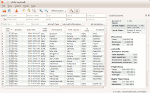
FSX, FSX SE, P3D Logbook Viewer and Extraction program.
Little Logbook allows fast and intuitive search and grouping of logbook entries based on several parameters as well as export to HTML, CSV and Google Earh KML documents.
Additional information about airports can be shown together with the MakeRunways utility of Peter Dowson.
New in 1.5.0:
* Now supports FSX, FSX SE, P3D V2 and P3D V3
* Detects paths to all simulators automatically
* Added Google Earth KML export
* Added import filter to ignore incomplete logbook entries
* HTML export now uses paging and creates multiple linked documents
* Added zoom functionality to change font size in table
* Other bug fixes and improvements - see included change log
The Software is released under the GPL. Source code is available. See http://albar965.github.io/littlelogbook.html for more Information.
| Filename: | Little_Logbook_150.zip |
| License: | Freeware |
| Added: | 20th January 2016, 22:40:37 |
| Downloads: | 1,389 |
| Author: | Alexander Barthel |
| Size: | 18.74 MB |
| Category: Prepar3D V1-4 - Utilities | |
| FS Flight Builder |
|
Images related to this file:
File Description:
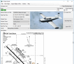
FS Flight Builder is a utility for general aviation flying that will build flight files for FSX (flt), FSX Steam Edition (flt), and Prepar3D (fxml) based on waypoints and other data either entered manually or imported from SkyVector using the Plain Text Link information. Among other things, you can select your starting position, aircraft, and a VFR or IFR flight plan.
One of the most interesting features of the application is that it will include a Briefing file, added to the aircraft's built-in kneedboard, that will include departure and destination airport information (runways, frequencies, weather, and charts) as well as navigation frequencies along the route.
Included is a new destination chooser function that allows you to enter your departure airport and additional criteria, such as min and max distance, tower required, ILS, runway length restrictions.
| Filename: | FS_Flight_Builder.zip |
| License: | Freeware |
| Added: | 30th July 2018, 03:56:07 |
| Downloads: | 148 |
| Author: | Tom Arduini |
| Size: | 28.24 MB |
| Category: Flight Simulator X - Scenery | |
| YBMC - Maroochydore (Sunshine Coast) Airport - Queensland, Australia **With Corrections** |
|
File Description:
With his permission this is Martin Hiesboeck's airport layout file (AFCAD) for the default FSX YBMC Maroochydore (Sunshine Coast) Airport in Queensland, Australia with two changes. (ATIS changed to 119.5MHz due to conflict with CTR freq 119.8 and Primary Rwy set to 36/18).
It features an enlarged apron, additional asphalt surfaces to accommodate the FSX default buildings, corrected gate numbers, jetways (which aren't there in reality - you can turn them off by reducing scenery complexity), added parking areas and vehicle pathways.
The runway is configured for noise abatement procedures usually in place: Landing RWY 36, Takeoff RWY 18 for all jets, such as not to disturb the sunseekers on the beach. Gate assignments are incomplete. Tested with WoAI AI only.
Original file uploaded by Martin Hiesboeck named ybmc_mh.zip with changes and renamed ymbc_mh2.zip.
| Filename: | YBMC__Maroochydore_Sunshine_Coast_Airport__Queensl.zip |
| License: | Freeware |
| Added: | 11th March 2015, 13:55:08 |
| Downloads: | 433 |
| Author: | Simon Hitch, Martin Hiesboeck |
| Size: | 115.59 KB |
| Category: Flight Simulator X - Scenery | |
| KCHO - Charlottesville-Albemarle Airport - Virginia, USA - BETA |
|
Images related to this file:
File Description:
FSX Scenery--Charlottesville-Albemarle Airport, VA. Beta Ver. Located in Albemarle County, Virginia, the Charlottesville-Albemarle Airport (KCHO) is a regional airport served regularly by American Eagle, Delta, United, and U.S. Airways. The airport also is home of Pegasus, an extension of the Department of Emergency Medicine at the University of Virginia Health System. General Aviation services are handled by Landmark Aviation, while aircraft charter is provided by the Meridian Air Group.
----------------
This 'beta' version of CHO is being released early to provide a destination for the upcoming 'Tom Allensworth Memorial Flight'. As such there are many unfinished features, additions and textures I had hoped to include. It is a Work In Progress. Please see the 'readme' for additional generic and freeware scenery .bgls needed. The finished version will include more accurate terminal, tower/firehouse, and FBO.
| Filename: | KCHO__CharlottesvilleAlbemarle_Airport__Virginia_U.zip |
| License: | Freeware |
| Added: | 27th April 2015, 13:00:48 |
| Downloads: | 906 |
| Author: | Joe Bowers |
| Size: | 9.62 MB |
| Category: Flight Simulator 2004 - Aircraft Repaints, Textures and Modifications | |
| United Airlines "Her Art Here" New York/New Jersey Boeing 757-200 |
|
Images related to this file:
File Description:

United's Her Art Here initiative promotes women's art; 51% of artists are women while only 13% of arts in museums were created by women. This Boeing 757 N14102 was designed by New Jersey native Corinne Antonelli, with a tribute to the NY/NJ region and the carrier's EWR hub. This livery features imagery from the two states including the Red Mill in New Jersey, the New York City skyline and the Statue of Liberty. This model features dynamic shine, opening passenger & cargo door, standard animations, realistic FDE, new detailed lighting effects, and much more. Model design by Hiroshi Igami. Flight dynamics design by Nate Rosenstrauch. Additional development, testing, and textures by TDS members Nick Wilkinson, Carlos Eduardo Salas, Yosuke Ube, Stian Svensen, David Biggar, and Luiz Antonio Perina. More information can be found at https://www.facebook.com/groups/214187952530554/ Enjoy!
| Filename: | United_Airlines_Her_Art_Here_New_YorkNew_Jersey_Bo.zip |
| License: | Freeware |
| Added: | 11th October 2019, 16:22:36 |
| Downloads: | 791 |
| Author: | Joe Shimmel | Tenkuu Developers Studio |
| Size: | 19.09 MB |
| Category: Prepar3D V1-4 - Scenery | |
| Bloukrans and Storms River (Paul Sauer) bridges – South Africa |
|
Images related to this file:
File Description:
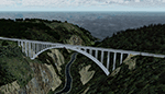
The Bloukrans and Paul Sauer (over the Storms river) bridges are on the N2 highway between Plettenberg Bay and Port Elizabeth on the scenic garden route in the Eastern Cape, South Africa. I made the custom scenery to try some Blender techniques using the P3D 4.5 SDK and tested it in P3D V5 using the ORBX Africa LC and Pilots NG2020 mesh products (I included a fix for the default V5 mesh). You will find the world's highest commercial bungee jump from the Bloukrans bridge, 216m above the river below. Take off from FAPG and fly a heading of 95 degrees for 32 km to get to the Bloukrans bridge (just off the coast). Follow the highway further east for another 26 km to get to the 120m high Paul Sauer bridge, where I included some additional eye candy.
| Filename: | Bloukrans_and_Storms_River_Paul_Sauer_bridges__Sou.zip |
| License: | Freeware |
| Added: | 14th July 2020, 19:15:53 |
| Downloads: | 179 |
| Author: | Johan Pienaar |
| Size: | 26.95 MB |


© 2001-2026 AVSIM Online
All Rights Reserved
Privacy Policy |