
Where Flight Simulation Enthusiasts Gather from Around the World!
AVSIM Library - Search Results

| Category: Flight Simulator 2004 - Scenery | |
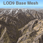
| Himalayas LOD9 Base Mesh, Volume 3 - Southwestern Ranges |

|
Images related to this file:
File Description:

Detailed terrain mesh of the Southwestern Himalayan Ranges, N28-37 E78-82. The files in this package are based on Shuttle Radar (SRTM) Version 2 data but with many of the void areas, especially the most significant sections, filled with elevation data generated from topographic maps by Jonathan de Ferranti. While Jonathan's work is unrelated to flight simulation he kindly gave me permission to compile his data for use in FS. The result is a wonderful improvement in detail and accuracy over any existing mesh file, freeware or commercial, based on SRTM or DTED data alone.
Due to the large area of the Himalayas I've compiled the source data as two separate series: the "Himalayan Peaks" series covers prominent mountains and ranges in higher detail and locally overrides any existing LOD9 terrain mesh. In addition, the LOD9 "base mesh" series, with LOD8 and LOD7 "buffer" mesh files, covering the entire Himalayas, is meant for those who do not yet have an add-on terrain mesh of these beautiful mountains.
| Filename: | Himalayas_LOD9_Base_Mesh_Volume_3__Southwestern_Ra.zip |
| License: | Freeware, limited distribution |
| Added: | 30th May 2010, 10:00:26 |
| Downloads: | 155,808 |
| Author: | Holger Sandmann, Jonathan de Ferranti |
| Size: | 62.16 MB |
| Category: Flight Simulator 2004 - Scenery | |
| Himalayas LOD9 Base Mesh, Volume 5 - Hindu Kush and Pamir |
|
Images related to this file:
File Description:

Detailed terrain mesh of the Hindu Kush and Pamir Ranges, N32-40 E70-76. The files in this package are based on Shuttle Radar (SRTM) Version 2 data but with many of the void areas, especially the most significant sections, filled with elevation data generated from topographic maps by Jonathan de Ferranti. While Jonathan's work is unrelated to flight simulation he kindly gave me permission to compile his data for use in FS. The result is a wonderful improvement in detail and accuracy over any existing mesh file, freeware or commercial, based on SRTM or DTED data alone.
Due to the large area of the Himalayas I've compiled the source data as two separate series: the "Himalayan Peaks" series covers prominent mountains and ranges in higher detail and locally overrides any existing LOD9 terrain mesh. In addition, the LOD9 "base mesh" series, with LOD8 and LOD7 "buffer" mesh files, covering the entire Himalayas, is meant for those who do not yet have an add-on terrain mesh of these beautiful mountains.
| Filename: | Himalayas_LOD9_Base_Mesh_Volume_5__Hindu_Kush_and_.zip |
| License: | Freeware, limited distribution |
| Added: | 29th May 2010, 08:57:29 |
| Downloads: | 7,603 |
| Author: | Holger Sandmann, Jonathan de Ferranti |
| Size: | 85.72 MB |
| Category: Flight Simulator 2004 - Scenery | |
| Himalayas LOD9 Base Mesh, Volume 2 - Southcentral Ranges |
|
Images related to this file:
File Description:
Detailed terrain mesh of the Southcentral Himalayan Ranges, N26-32 E82-90. The files in this package are based on Shuttle Radar (SRTM) Version 2 data but with many of the void areas, especially the most significant sections, filled with elevation data generated from topographic maps by Jonathan de Ferranti. While Jonathan's work is unrelated to flight simulation he kindly gave me permission to compile his data for use in FS. The result is a wonderful improvement in detail and accuracy over any existing mesh file, freeware or commercial, based on SRTM or DTED data alone.
Due to the large area of the Himalayas I've compiled the source data as two separate series: the "Himalayan Peaks" series covers prominent mountains and ranges in higher detail and locally overrides any existing LOD9 terrain mesh. In addition, a LOD9 "base mesh" series, with LOD8 and LOD7 "buffer" mesh files, covering the entire Himalayas, is meant for those who do not yet have an add-on terrain mesh of these beautiful mountains.
| Filename: | Himalayas_LOD9_Base_Mesh_Volume_2__Southcentral_Ra.zip |
| License: | Freeware, limited distribution |
| Added: | 29th May 2010, 09:05:56 |
| Downloads: | 9,448 |
| Author: | Holger Sandmann, Jonathan de Ferranti |
| Size: | 90.25 MB |
| Category: Flight Simulator 2004 - Panels | |
| VFR/Landing View for "Level-D Simulations: The 767" |
|
File Description:
After a lot of hard work, and help and advice from 757/767 captains, I'm proud to release this small add-on for "Level-D Simulations: The 767"! This view has been verified by pilot's to be close to the "real-thing"! I have created two styles of these panels. One with the Radar-Altimeter tape (like AAL and Delta use on their 767-300s) and one without (like UAL). Both were made to work more seemlesly with PIC 767. Landing your 767 will never be the same again... Special thanks to "Jake" at www.airliners.net; without his input and photos, this panel would not exist.
DISCLAIMER: THESE FILES ARE THOROUGHLY TESTED. HOWEVER, THEY ARE TO BE USED AT YOUR OWN RISK!!!
Level-D is not responsible for any modifications to their product. Send an E-Mail to [email protected] with any comments or technical difficulties!
| Filename: | VFRLanding_View_for_LevelD_Simulations_The_767.zip |
| License: | Freeware, limited distribution |
| Added: | 18th October 2005, 10:22:05 |
| Downloads: | 5,291 |
| Author: | Philip A. Geddes |
| Size: | 863.24 KB |
| Category: Flight Simulator 2002 - Scenery | |
| New 300-m (LOD7) Terrain Mesh of British Columbia and Southeast Alaska #4 |
|
File Description:
Mid-resolution (300-m) terrain mesh for the entire province of British Columbia (950,000 square km) and the Alaska panhandle southeast of N60 W139. Made from 250m-resolution source data without oversampling. Easy on frame rates and hard drive space. It transforms the rounded mountains of the default terrain mesh into a much more realistic representation of the diverse topography of this beautiful corner of the world. Experience the spectacular scenery between Vancouver and Atlin, Juneau and Fort St. John, and Mount Robson to Clayoquot Sound. Fourteen independent mesh tiles allow you to select the region(s) you like best. Several high-resolution add-on meshes will be uploaded separately. By Holger Sandmann. Part 4 of 4: All areas between 48 and 51 degrees North. Note: this part contains updated read-me.txt and .pdf files - please use these instead of the ones distributed with the first three parts!
| Filename: | New_300m_LOD7_Terrain_Mesh_of_British_Columbia_and.zip |
| License: | Freeware, limited distribution |
| Added: | 17th January 2003, 20:22:07 |
| Downloads: | 3,677 |
| Author: | Holger Sandmann |
| Size: | 6.34 MB |
| Category: Flight Simulator 2004 - Scenery | |
| Webster OFL (KNUI) for UT/USA |
|
File Description:
Webster Field is an outlying airport realted to PAX Naval Air Test Center in Maryland. According to what I have read, they use the airport mainly to test unmanned aircraft.
In a support note I saw an image of this airfield in Ultimate Terrain showing its runways extending out into the water. So I fixed it. I couldn't find much more info on it other than that on www.AirNav.com, so I've just kept the default layout for the most part. I did have to rotate the runways a bit to match the satellite photo about 10 degrees for 14/32. I kept the runway labels, however as that is how they are listed in Airnav and show up in the satellite photo. If anyone has any further info I'd be happy to add to it.
This version is meant for use with Ultimate Terrain USA.
| Filename: | Webster_OFL_KNUI_for_UTUSA.zip |
| License: | Freeware |
| Added: | 23rd February 2006, 05:20:49 |
| Downloads: | 377 |
| Author: | Thomas Perry |
| Size: | 218.88 KB |
| Category: Flight Simulator 2004 - Scenery | |
| HSMK Rumbek, Sudan |
|
File Description:
Googly scenery for HSMK Rumbek, a small airport serving the city of the same
name, capital of the Buhayrat (or Lakes) state in southern Sudan. The airport
is served daily by Beech 1900 aircraft operating for Delta Connection, a
Kenyan airline.
Flight Simulator 2004 has completely omitted this airport and this scenery
seeks to redress the situation so that you and your "AI" traffic can use the
airport.
The scenery does not purport to be ultra-accurate. Based on high quality
satellite imagery from Google Earth, the layout is proportionally correct but the
added airport features, such as buildings, are built from default Microsoft objects
and add-on libraries so will not look exactly like the real thing.
You are not obliged to download and install any additional scenery libraries,
but to enjoy this scenery in its entirety, you may wish to. It will work fine,
with or without.
| Filename: | HSMK_Rumbek_Sudan.zip |
| License: | Freeware |
| Added: | 19th April 2008, 20:33:09 |
| Downloads: | 754 |
| Author: | John Hinson |
| Size: | 78 KB |
| Category: Flight Simulator X - Aircraft Repaints, Textures and Modifications | |
| Aerosoft F-16C WP 8th Fighter Wing HAVEGLASS V Repaint Texture Package |
|
Images related to this file:
File Description:
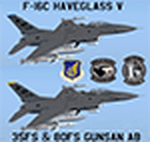
This package contains TWO Gunsan AB 8th Fighter Wing F-16C HAVEGLASS V repaint textures for the Aerosoft F-16! The first jet is 89-2058 from the 36th FS, and the second is 90-0745 from the 80th FS. The latest versions of HAVEGLASS F-16s (as of 2023) now have black markings/decals on the jet instead of the grey markings on earlier versions. Many thanks to the people who posted pictures of the latest HAVEGLASS Wolfpack jets online!
Since the HAVEGLASS F-16s primary mission is "Wild Weasel" SEAD/DEAD, I included instructions below to install both textures into the "Aerosoft F-16C 120-9-88-370-184" folder. Also, I made sure these textures will work with ALL the other Aerosoft F-16 models (with or without the drag chute) so feel free to add these textures to your favorite ones. YGBSM!
| Filename: | Aerosoft_F16C_WP_8th_Fighter_Wing_HAVEGLASS_V_Repa.zip |
| License: | Freeware |
| Added: | 27th July 2023, 22:46:28 |
| Downloads: | 84 |
| Author: | Daniel Gregory |
| Size: | 8.08 MB |
| Category: Flight Simulator X - AI Flight Plans | |
| Sky Regional - Summer 2018 |
|
Images related to this file:
File Description:

Current flight plan of Sky Regional for summer 2018.
Sky Regional Airlines is an airline whose corporate headquarters is on the property of Toronto Pearson International Airport, Mississauga, Ontario, Canada. Linked with Skyservice Business Aviation, it began operation under the Air Canada Express brand on May 1, 2011. The airline began offering daily flights between Toronto Island and Montréal–Pierre Elliott Trudeau International Airport.
Sky Regional introduced a fleet of Embraer 175 jets in March 2013 to serve US destinations such as New York, Newark, Boston, Philadelphia, Chicago, and Dallas/Fort Worth.
Between October and December 2015 the fleet of 20 was expanded to 25 after obtaining 5 additional Embraer 175 previously operated by Azul Brazilian Airlines. These aircraft were put into service in April 2016 allowing the airline to add routes to more US destination such as Denver International Airport, and Hartsfield-Jackson Atlanta International Airport.
| Filename: | Sky_Regional__Summer_2018.zip |
| License: | Freeware |
| Added: | 12th August 2018, 19:31:54 |
| Downloads: | 262 |
| Author: | Frank Drebing |
| Size: | 26.07 KB |
| Category: Flight Simulator 2002 - Scenery | |
| Historical Galata Tower - Istanbul |
|
File Description:
Well, hello all, again with another historical Scenery Add On for Istanbul city...
This is the Famous Galata Tower, located at the center point of Sishane, between Halic (Golden Horn) and Galata coasts. Also the tower where Hezarfen Ahmet Celebi has tried the first flight from, with the attached hand made wings, sides of his body. This was also the first try of the world about Aero Dynamics and the first step to Flight for human explorings. The users who follow the TASD Team products will now remember that we`ve released Hezarfen Airport / Istanbul, this is the same Turkish Scientist - Aerodynamic physicist man now the goverment putted the name on the Airport we released beforehand...
Plus, the city buildings Scenery you see behind is, from `Istanbul Great Scenery Pack` again by TASD Team, which is still under construction and will be released at the end of August.
| Filename: | Historical_Galata_Tower__Istanbul.zip |
| License: | Freeware, limited distribution |
| Added: | 28th July 2002, 23:45:52 |
| Downloads: | 1,275 |
| Author: | The TASD Team / Toplama Adamlar Scenery Design |
| Size: | 212.76 KB |
© 2001-2026 AVSIM Online
All Rights Reserved
Privacy Policy |