
Where Flight Simulation Enthusiasts Gather from Around the World!
AVSIM Library - Search Results

| Category: Flight Simulator 2004 - Aircraft Repaints, Textures and Modifications | |
| Roman Abramovich Private Boeing 767-33A/ER (P4-MES) |

|
Images related to this file:
File Description:
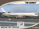
I am proud to present this SkySpirit 2010 V5 model of the Boeing 767-33A/ER owned by billionaire Roman Abramovich. This aircraft bears the Aruban registration P4-MES, and was nicknamed "The Bandit" because of the mask painted around the cockpit windows. This is one of the largest aircraft owned and used by a private individual. It is operated for its owner by Global Jet Luxembourg, callsign "Silver Arrows." This livery is quite elegant and understated for such a "go big" owner. Although flight plans for this aircraft are hard to come by as its registration is blocked when in flight, it makes regular, frequent appearances in Innsbruck (LOWI) and St. Maarten (TNCM). It also shows up at many destinations outside Russia including; Stansted(EGSS), Vienna (LOWW) and Zurich (LSZH). In case you are curious, Roman Abramovich himself is in the captain's seat on this repaint. I tried to make this repaint as accurate as possible. However, the satellite system on the real P4-MES is not representable on this model. The repainted textures in this package are 32-bit with no mipmaps for best clarity and quality. This is a complete install. This package contains SkySpirit2010 B767-300 V5 model, air and config files. The sound is from the default 737.
| Filename: | Roman_Abramovich_Private_Boeing_76733AER_P4MES.zip |
| License: | Freeware, limited distribution |
| Added: | 4th October 2011, 05:20:16 |
| Downloads: | 1,582 |
| Author: | Jeffrey S. Bryner, SkySpirit2010 |
| Size: | 12.33 MB |
| Category: Flight Simulator 2004 - Scenery | |
| Clyde River CYCY & Cape Christian in Nunavut Canada |
|
Images related to this file:
File Description:
Clyde River is a village on the northeast coast of Baffin Island, 250 miles above the Arctic Circle and around 150 miles north of Cape Hooper. It is on the shore of Patricia Bay at the entrance to Cylde Inlet, a fjord which stretches over 60 miles inland. The population is around 880 folks, and it was named by the explorer John Ross in 1818. The airfield is just east of the village and the lighted runway is 3,501' of 100' wide gravel at 87' ASL, aligned 018 True 198 True; "True" as opposed to magnetic in the Northern Domestic Airspace. There are two aprons, one with the new terminal building and one with the old terminal and the garage. Five miles northeast of Clyde River is Cape Christian, where there is a gravel runway around 3,000' long and adjacent to the beach, built to serve what was started as a weather station and later became a LORAN navigation system station. The station is still there, though it was closed some time ago and is now the subject of decontamination work. The runway is usable, though only for light planes as it is a bit rough. First Air and Canadian North are the AI planes visting Clyde River.
| Filename: | Clyde_River_CYCY__Cape_Christian_in_Nunavut_Canada.zip |
| License: | Freeware |
| Added: | 14th July 2011, 20:26:14 |
| Downloads: | 454 |
| Author: | Roger Wensley |
| Size: | 3.33 MB |
| Category: Flight Simulator 2004 - Scenery | |
| Cape Hooper CWFH and FOX-4 DEW Line Station in Nunavut, Canada |
|
Images related to this file:
File Description:
Cape Hooper is around 60 miles north of Kivitoo (FOX-D) and 140 miles south of Clyde River CYCY on the northeast-facing coast of Baffin Island. FOX-4 is still in use as a new and mostly-unmanned North Warning System site was established there in 1990 before the DEW line station was closed in 1991. Actually the DEW line station was not "closed" as such, they just stopped using it. The site of FOX-4 is on the top of a bump at the end of one of many long promontories that stick out into the Davis Strait between Baffin Island and Greenland, close to the far eastern end that is called Cape Hooper. There is a gravel runway to the west, down at 65' ASL; it is only just over 3,000' long and most material was delivered by sea to the beach at the southern end of the runway. The runway is signed as
"324T - 144T" as this is Northern Domestic Airspace where all runways are signed "true" and not "magnetic"; it is 013/193 magnetic with a huge magnetic variation of 48.9 degrees in this area where the magnetic field is mostly vertical, and so useless for navigation.
| Filename: | Cape_Hooper_CWFH_and_FOX4_DEW_Line_Station_in_Nuna.zip |
| License: | Freeware |
| Added: | 11th July 2011, 00:28:40 |
| Downloads: | 411 |
| Author: | Roger Wensley |
| Size: | 1.65 MB |
| Category: Prepar3D V5 - Scenery | |
| VOMM_P3Dv5 |
|
File Description:
Chennai International Airport (IATA: MAA, ICAO: VOMM) is an international airport serving the city of Chennai, Tamil Nadu, India, and its metropolitan area. It is located in Tirusulam, 21 km (13 mi) from the city centre. Chennai International Airport is the third busiest in international traffic and cargo capacity in the country behind New Delhi and Mumbai.[4][5] It is also 49th busiest airport in Asia making it one of the four major airports in India under the top 50 list.[6] The airport is served by the airport metro station of the Chennai Metro and the Tirusulam railway station of the Chennai Suburban Railway system. To cope with the passenger traffic, two new terminals, namely, T2 and one satellite terminal, are under construction to handle 40 million passengers per year.[7] Once completed, it will be India's first airport to have a satellite terminal. The new satellite terminal will be connected through a four way underground walkalator for passenger movement across different terminals.[8] Still, the Tirusulam airport complex is expected to reach saturation by 2035, with a peak capacity of 40 million passengers, and a proposal for a new greenfield airport in Chennai is underway for decades. Once the new airport is commissioned, both the airports will be functional.
| Filename: | VOMM_P3Dv5.zip |
| License: | Freeware |
| Added: | 20th October 2020, 23:18:27 |
| Downloads: | 1,375 |
| Author: | Abhishek Banerjee |
| Size: | 14.68 MB |
| Category: Flight Simulator X - Scenery | |
| KFHR Friday Harbor Photoreal |
|
Images related to this file:
File Description:
This Scenery consists of the FSX default airport of Friday Harbor, set on photorealistic terrain. Although the scenery has been compiled with night masks, night terrain has been excluded to reduce the file size. It has been designed for Megasceneryearth photorealistic scenery of the San Juan Islands but will also work with the default terrain. Seasonal variations are not included. The main scenery file has been subdivided into several smaller files, which can be switched off according to user preference. Full night textures are included with wash lighting in the terminal and carpark areas. All buildings have been custom modelled using real photographs, and include open hangers with interiors.
Next to the fuel station you will find Ernie's Cafe, much loved by resident and visiting pilots. Close to the airport you will find US style houses modelled on real photographs from the San Juan island. Surfaced airport taxiways and aprons have been kept to a minimum to allow the photoreal textures to show through. The scenery also includes sound effects and high definition people, these can be switched off if they place too much strain on your system. Please enjoy, and I hope you like my scenery as much as I enjoyed making it.
| Filename: | KFHR_Friday_Harbor_Photoreal.zip |
| License: | Freeware, limited distribution |
| Added: | 9th January 2012, 00:46:11 |
| Downloads: | 4,071 |
| Author: | George Keogh |
| Size: | 65.88 MB |
| Category: X-Plane - Scenery | |
| BR AM SWMK - Maturaca Airfield v1.0.0 |
|
Images related to this file:
File Description:
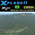
This is an X-Plane 11 and X-Plane 10 scenery package for Maturaca Airport (ICAO: SWMK, no IATA code) which is an airport serving Maturaca village, in São Gabriel da Cachoeira, Amazonas, Brazil, located in the vicinity of "Pico da Neblina" (Peak of the Haze, in English), the highest mountain in Brazil, 2,995.3 metres (9,827 ft) above sea level, in the Serra da Neblina, part of the Serra do Imeri, a section of the Guiana Highlands on the Brazil–Venezuela border, in the middle of the Amazon rainforest. It includes corrected aprons, ramps, gates, taxiways, lighting system, village buildings, ortho-photoscenery for the airfield area, and (XP11 only) airport ground services (like push back). This scenery was tested and is operational (as of April 14, 2017) in "X-Plane 11.00 RC #1 64 bit", Windows 10 Home. It was also tested and is also operational (as of April 14, 2017) in "X-Plane 10.51 64 bit", Windows 10 Home. Only the default X-Plane 11 libraries, by Laminar Research, are needed. No third party libraries are used.
A few extra objects are used and included in the package, thanks to artist Paulmort (Hangar 24, Hangar House, Ranch House, Deluxe Log Cabin, Hangar Barn) and to artist Capnsully (Grow Grass for Xplane). They are included in the package, no need to download them.
| Filename: | BR_AM_SWMK__Maturaca_Airfield_v100.zip |
| License: | Freeware |
| Added: | 15th April 2017, 06:23:29 |
| Downloads: | 132 |
| Author: | Rui Mesquita |
| Size: | 35.57 MB |
| Category: Flight Simulator 2004 - Panels | |
| New Vickers VC10 Panel, Part 4 - Missing bmp files |
|
File Description:
There were 2 missing bmps relating to Nav_Info from my 'New Vickers VC10 Panel, Part 4' (new_vc10_panel_project_4_maintenance_2.zip). In order for it to work correctly you need these files.
This project is based on David Maltby's panel. This update the first in the 50th Anniversary year of the VC10 (there are currently nine still flying) brings to fruition a number of extensive works in progress that have involved almost every gauge! The aircraft now has a fully integrated pressurisation and oxygen delivery system that conforms not only to the Flight Manual but also to ICAO regulations. Therefore cockpit mismanagement can potentially result in hypoxia! Besides this there are also a large number of new additions both in conformity with the Flight Manual and as extra visuals. It's now possible to "see" the Marshaller - There are new speed calls - and whilst you are preoccupied with your checklists the ground staff can be heard going about their business preparing for the flight as indicated also on the Ignition Panel. For a full list of changes view the VC10 Panel Update 4.doc
For this latest update thanks must go to Edi Hirsch for his excellent NavInfo gauges and again to the Gurus at FSDeveloper.com for their advice. To install make sure you have installed the previous (linked) files beforehand.
| Filename: | New_Vickers_VC10_Panel_Part_4__Missing_bmp_files.zip |
| License: | Freeware |
| Added: | 11th April 2012, 18:28:42 |
| Downloads: | 1,352 |
| Author: | Nicholas Weber |
| Size: | 10.5 KB |
| Category: Prepar3D V1-4 - Utilities | |
| AICull In-Sim Traffic Density Setting Tool |
|
Images related to this file:
File Description:

AICull v1.0.1 is a simconnect utility designed to provide AI traffic limiter options from within the P3D simulation via a menu system located under the “Add-ons†menu. AICull uses a “Smart Retain X Current ICAO†mode (accessible via the AICull in-sim menu under add-ons) that automatically maximizes arrival and departure activity at the user’s current ICAO while still retaining “X†number of AI. Alternately,the user can chose to simply retain “X†number of AI closest to the user’s aircraft. AICull also provides the options to limit AI traffic to the user’s departure and destination airports (if a P3D flight plan loaded). In all of the above cases, exceptions can be made for enroute AI (e.g., higher than 10,000 ft AGL or 18,000 ft AGL). The user can also customize preset values for the “X†retention number. AICull works best for .bgl file based traffic solutions (e.g., AIG). Although AICull will also work with simconnect-based traffic injectors (e.g., UTL), they typically perform their own AI traffic limiting and may also re-inject traffic that AICull deletes. AICull require the installation of FSUIPC v5 or later, registered (preferred) or unregistered. AICull is fully compatible with AIFlow and AIGround. Ver 1.0.1 FIX: changes to AICull.ini file not being read.
| Filename: | AICull_InSim_Traffic_Density_Setting_Tool.zip |
| License: | Freeware |
| Added: | 10th July 2020, 18:21:59 |
| Downloads: | 702 |
| Author: | Roland Foster |
| Size: | 946.98 KB |
| Category: Flight Simulator X - Aircraft Repaints, Textures and Modifications | |
| FSX/P3D Ethiopian Airlines 707-379C 1968 |
|
Images related to this file:
File Description:
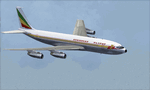
This is a repaint of the 707-379C in Ethiopian Airlines colors. The payware 707-300C by Captain Sim is needed for this repaint. Ethiopian Airlines was established in 1946 by the Emperor Haile Sellassie, and TWA which provided technical and managerial support. Regular operations commenced on April 8 1946 with a fleet of 6 ex USAAF DC-3s. Later in 1950, 2 Convair CV-240s entered the fleet. Then in 1958, the first DC-6B arrived on the scene. On January 1 1959 Ethiopian officially became a member of IATA. The first jet services started in 1963 after the delivery of the carrier's first Boeing 720s. The 720s replaced the DC-6Bs on the European routes. In 1964, Ethiopian started a new pilot training school, installed a large IBM computer system, and also established the largest jet overhaul facility in Africa. 707s, 727s, and 737s, joined the fleet in the ensuing years. Today Ethiopian ranks as Africa's supreme air carrier with a safe and reliable service, notwithstanding the 737 Max 8 tragedy, and has a vast route network. The cherry on top was when in 2014, Ethiopian dethroned South African Airways as the "Best African Airline". Textures are 32 bit dds and DXT5 textures are included as well. This repaint was tested FSX-SE. It should work on FSX & P3Dv1-3.
| Filename: | FSXP3D_Ethiopian_Airlines_707379C_1968.zip |
| License: | Freeware |
| Added: | 20th September 2019, 16:33:20 |
| Downloads: | 131 |
| Author: | Ted Giana |
| Size: | 20.14 MB |
| Category: Flight Simulator X - Scenery | |
| Columbia SC (KCAE) |
|
Images related to this file:
File Description:
The Columbia Metropolitan Airport Authority has provided substantial information about KCAE online, making it possible to pretty accurately model this airport. The taxiway signs have been placed according to exhibits in the airport's certification manual, and taxiway designations have been revised in accordance with upgrades to be effective mid-Novemer 2012. Most buildings have been custom modeled in accordance with information available on the internet, including Microsoft Bing birdseye views. The airport layout and landclass changes are in accordance with Google Earth imagery.
If you have Jim Dhaenens' lightobj.bgl installed, apron lighting will be included, and if you have
KB_static_aircraft_FSX installed (available at www.kb-sim.com/screens_static_aircraft.html),
additional parked aircraft will be visible. The layout of scenery is optimized for use with
Ultimate Terrain X-USA. FSX runs smoothly with this scenery on my computer, but it has not been
tested on a low-end system. Sometime after starting this project, it came to my attention that a
good scenery for KCAE was already available (but not listed at www.freewarescenery.com) from Jim
Hill that is another option as well as adjusting scenery complexity.
The new taxiway designations are not yet shown in the latest observed FAA airport diagram. An airfield sketch provided to pilots by the Columbia Metropolitan Airport is included in the package to show the taxiway designation changes.
| Filename: | Columbia_SC_KCAE.zip |
| License: | Freeware |
| Added: | 14th December 2012, 01:28:23 |
| Downloads: | 1,694 |
| Author: | Art Poole |
| Size: | 3.43 MB |
© 2001-2026 AVSIM Online
All Rights Reserved
Privacy Policy |