
Where Flight Simulation Enthusiasts Gather from Around the World!
AVSIM Library - Search Results

| Category: Flight Simulator 2004 - Aircraft Repaints, Textures and Modifications | |
| Thai AirAsia - Updated 9M-AAN "Carabow" |

|
File Description:
Airasia's Thai service aircraft with "Carabao" livery (9M-AAN)
Air Asia is a low-cost no frills Malaysian airline which operates
flights from Kuala Lumpur International Airport to various destinations
throughout Malaysia. It operates exclusively on Boeing 737-300 aircraft.
Thai Airasia is a jointventure company between Shin corp. Thailand
and Airasia Malaysia. Two aircraft are initialy used for thai domestic
flights using Bangkok Intl. as a hub with a plan to increase the number
upto 10 at the end of the year2004. Carabao(meaned buffalo) is a folk
star of Thailand and Thai Airasia presenter.
-----
In this updated package, the Malay flag at the nose was moved to the side of the
frontal door,funny appearance of grey painted over area can be seen at the nose.
Main wheel red button was also added.
-----The folder contains all you need for flying the "CARABAO" ,just unzip and paste.
This aircraft has a ving view function and is as easy to fly as the default 737-400 and also very suitable for AI too!
| Filename: | Thai_AirAsia__Updated_9MAAN__Carabow.zip |
| License: | Freeware |
| Added: | 7th August 2004, 21:58:42 |
| Downloads: | 1,342 |
| Author: | Anuraka Siriwatra |
| Size: | 2.91 MB |
| Category: Flight Simulator 2004 - Aircraft Repaints, Textures and Modifications | |
| LAN Airlines Airbus A320-233 (CC-COC) with Lighting Effects and Updated FDE |
|
File Description:
LAN Airlines, S.A. was formerly known as LAN Chile and is based Santiago, Chile with its main hub at Arturo Merino Benítez International Airport (SCEL) in Santiago. It also operates hubs in Lima, Peru Buenos Aires, Argentina Miami, Florida USA and Quito and Guayaquil Ecuador. LAN Airlines comprises LAN Chile, LAN Argentina, LAN Peru, LAN Ecuador and LAN Express.
I delayed the release of this aircraft after seeing the recent release by Dave Wilkins of high-quality LAN Airlines AI Aircraft using the EvolveAI models. After downloading and installing them myself, I thought it would be a nice complement if the colors of this A320 matched the colors of David's LAN Airlines AI A320's, A319's and A318. I think the result is quite nice and hope you agree.
This full installation package includes the Project Airbus A320 IAE V2 model and air files, a modified FDE (with permission from Peter Binamira of Project Airbus), A320 lighting enhancements and 32-bit textures. Uses default 737-400 panel and sounds. Please see Install.txt for installation details.
| Filename: | LAN_Airlines_Airbus_A320233_CCCOC_with_Lighting_Ef.zip |
| License: | Freeware, limited distribution |
| Added: | 25th August 2007, 12:46:08 |
| Downloads: | 2,922 |
| Author: | Project Airbus, Jeffrey S. Bryner, Grayson Ottaway |
| Size: | 6.26 MB |
| Category: Flight Simulator 2004 - Scenery | |
| Groom Lake / Area 51 Scenery - KXTA |
|
File Description:
This package will add the missing Area 51 airport (credited as KXTA according to some sources) to Flight Simulator 2004: A Century of Flight. It will add the following items, but YOU CONTROL IF THEY ARE ACTIVE IN FS2004 via the scenery library (directions are included in the manual):
* KXTA in the proper location with assocated scenery including airport buildings, antenna arrays on Bald Mountain and Papoose Mountain, even an SUV in the general location of "Freedom Ridge"; the one time favortie observation point for civilians wanting to keep an eye on what our "Uncle" is up to out there in the desert.
* New KLAS, KLSV, and KINS to add appropriate parking (Again you don't HAVE to use them, so if you already have a MOD for one of these, you can simply elect not to activate mine)
* New skin for the default 737-400 in EG&G Janet colors.
* AI F-22 Raptor
* AI Flight plans for the F22s and Janet 737s (Janet flights based on real world schedules as found at www.dreamlandresort.com)
| Filename: | Groom_Lake__Area_51_Scenery__KXTA.zip |
| License: | Freeware |
| Added: | 2nd March 2008, 02:07:17 |
| Downloads: | 4,622 |
| Author: | Ted Thompson |
| Size: | 5.26 MB |
| Category: Flight Simulator 2004 - Aircraft Repaints, Textures and Modifications | |
| JetBlue 'Boston Red Sox', Airbus A320-232 (N605JB) |
|
Images related to this file:
File Description:
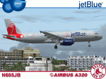
JetBlue Airways, the official airline sponsor of the Boston Red Sox, unveiled this A320-232 bearing the Boston Red Sox logos and became the first commercial aircraft to officially wear a Major League Baseball uniform/logo. Here's a description taken from JetBlue's press release regarding the details included on this aircraft; "this special A320 trades its signature JetBlue branding for a gray paint scheme inspired by the classic Red Sox road uniforms complete with blue wing fences with the Red Sox 'B'and a gray tail featuring the team's iconic dangling red socks. The aircraft also includes a banner (below the pilot's windows) commemorating Fenway Park's 100th anniversary alongside the JetBlue and Red Sox logos." I hope all you MLB fans and Boston Red Sox fans enjoy flying this wonderful aircraft as much as I did creating it. Repainted textures in this package are 32-bit with no mipmaps for best clarity and quality. This is a complete install package. The Project Airbus A320 V2.1 model and air files are included. Uses default 737-400 panel and sounds. Please see Readme.txt for more details.
| Filename: | JetBlue_Boston_Red_Sox_Airbus_A320232_N605JB.zip |
| License: | Freeware, limited distribution |
| Added: | 20th February 2012, 16:25:31 |
| Downloads: | 2,100 |
| Author: | Jeffrey S. Bryner, Project Airbus |
| Size: | 11.02 MB |
| Category: Flight Simulator 2004 - Scenery | |
| Clinton Point CWCP, Horton River CWHR & Keats Point CWKP; DEW sites in Northwest Territories, Canada |
|
Images related to this file:
File Description:
These are three DEW line sites in northern mainland Canada, to the east of Tuktoyaktuk.
Clinton Point is almost 300 miles east of Tuktoyaktuk and on the Northwest Territories and Nunavut border. It is the site of a closed DEW station (closed in 1993) and all the buildings have been removed, unlike many other sites where buildings are still almost complete. The roads and the gravel runway down by the beach are still there.
Horton River is 150 miles east of Tuktoyaktuk, up on higher land above the cliffs at around 500 feet ASL. The NWS (North Warning System) replaced the I site which was there previously and which ceased operations in 1963. The NWS is serviced by helicopter from a barge 400 yards away on the beach.
Keats Point is 270 miles east of Tuktoyaktuk, 7 miles from the coast but significantly close to a lake, which was probably used for float plane delivery in the summer (or ski plane delivery in the winter) of NWS station elements during construction.
| Filename: | Clinton_Point_CWCP_Horton_River_CWHR__Keats_Point_.zip |
| License: | Freeware, limited distribution |
| Added: | 17th July 2012, 18:57:08 |
| Downloads: | 282 |
| Author: | Roger Wensley |
| Size: | 2.07 MB |
| Category: Flight Simulator X - Scenery | |
| Barbados Island Scenery V2 |
|
File Description:
UPDATED 01/05/2017
Photoscenery for Barbados island for FSX/P3D
Thank you for downloading my first scenery.
I've decided to make my first scenery of my home island Barbados, am very proud of my work and I hope you enjoy it.
UPDATE:
Fixed the Blendmask
Fixed the watermask
added rivers, port and more to the watermask
Barbados is a sovereign island country in the Lesser Antilles, in the Americas. It is 34 kilometres (21 miles) in length and up to 23 km (14 mi) in width,
covering an area of 432 km2 (167 sq mi). It is situated in the western area of the North Atlantic and 100 km (62 mi) east of the Windward Islands and the Caribbean Sea;[6] therein,
it is about 168 km (104 mi) east of the islands of Saint Vincent and the Grenadines and 400 km (250 mi) north-east of Trinidad and Tobago. Barbados is outside of the principal Atlantic hurricane belt.
Its capital is Bridgetown. Barbados is 1,600 mi (2,600 km) Southeast of Miami.
| Filename: | Barbados_Island_Scenery_V2.zip |
| License: | Freeware |
| Added: | 6th January 2017, 08:36:45 |
| Downloads: | 1,791 |
| Author: | Shakur Jones |
| Size: | 80.48 MB |
| Category: Flight Simulator 2004 - Aircraft Repaints, Textures and Modifications | |
| Alaska Air Cargo Boeing 737-700BDSF |
|
Images related to this file:
File Description:
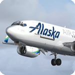
In September 2017, Alaska Airlines began service with it's converted 737-700 freighter aircraft. Formerly used for passenger service, these aircraft were converted to an all-cargo configuration in Tel Aviv by Israel Aerospace Industries over a period of 19 months. Alaska will convert a total of three 737-700s into freighters, allowing the new, all-cargo fleet to carry 15 percent more capacity overall. These aircraft will replace the aging half-passenger half-cargo 737-400 combi fleet.
Model developed by Tenkuu Developers Studio, features high resolution textures, dynamic flexing wings, nose gear steering, rudder lock, ground spoilers, low speed aileron locks at high speed, fully animated control surfaces, fully independent suspension, trim animation, opening passenger doors, rolling wheels, animated thrust reversers with reverser block doors, detailed textures, full night lighting, custom Alaska ground service vehicles and more. Model design by Hiroshi Igami. Flight dynamics design by Nick Wilkinson, with assistance from David Biggar. Master textures and paint kit by Kyle Schurb. Painted on the great TDS model. Enjoy!
| Filename: | Alaska_Air_Cargo_Boeing_737700BDSF.zip |
| License: | Freeware |
| Added: | 15th October 2017, 04:25:27 |
| Downloads: | 739 |
| Author: | Joe Shimmel | Tenkuu Developers Studio |
| Size: | 16.3 MB |
| Category: Prepar3D V1-4 - AI Flight Plans | |
| Royal Air Cambodge 1998 AI Flightplans |
|
File Description:
Royal Air Cambodge was about halfway through it's life in 1998, having started in 1994 and closed in 2001. The airline was flying a pair of 737-400s to several of the major Asian port cities within 2-3 hours flying time, while the 3 ATR-72s did domestic flying and served the nearby Asian nations. Though I can not find record of more than 3 ATRs, but the flight schedule calls for 5 aircraft. There are quite a few flights that were unable to be covered by the 3 ATRs, so I wonder if some were leased at the time, but I am unable to confirm this. The planes are segregated, but again they do represent a decent portion of the flights. Links to the OSP ATR-72 and FAIB 737-400 repaints are included. Flightplans by Chasen Richardson. Part of the 1998 Flight Simulator Project. Follow us on Facebook at facebook.com/flightsim98 and on instagram as @bayviationsim. For more Retro AI, check out the forums at: http://retroai.proboards.com/
| Filename: | Royal_Air_Cambodge_1998_AI_Flightplans.zip |
| License: | Freeware, limited distribution |
| Added: | 21st November 2019, 19:15:08 |
| Downloads: | 48 |
| Author: | Chasen Richardson\Bayviation |
| Size: | 390.18 KB |
| Category: Flight Simulator 2004 - Scenery | |
| Koyuk PAKK in Alaska |
|
Images related to this file:
File Description:
Koyuk is a coastal village around 125 miles east of Nome at the mouth of the Koyuk River, with a population just under 400 living from fishing and the land. The airfield is close by and has a gravel runway aligned 18-36, 3,300 feet long with VASI at both ends. Apart from the airfield itself, and it's buildings, this scenery modifies the local land class, adds village buildings while reducing the village size to reality, and creates a new airfield background. Bering Air and ERA both fly into Deering and are included in the AI. A note here about my scenery making. This is post number 506 and there will not be many more to follow this as I am almost at the end of the photos I either took or found for scenery purposes. There is a limit to what can be located online and I have already been making use of the little there is; eg Unalakleet. So, if you are near an airport (preferably Canadian or Alaskan) and have a camera..... Let me know.
| Filename: | Koyuk_PAKK_in_Alaska.zip |
| License: | Freeware, limited distribution |
| Added: | 15th August 2019, 17:56:50 |
| Downloads: | 142 |
| Author: | Roger Wensley |
| Size: | 3.88 MB |
| Category: Flight Simulator 2004 - Scenery | |
| Kimmirut CYLC on Baffin Island in Nunavut, Canada |
|
Images related to this file:
File Description:
Kimmirut is a village of some 400 folks at the southern end of the southwest-facing coast of Baffin Island, 75 miles southwest of Iqaluit. It is on the northern side of the Hudson Strait between Baffin Island and Quebec, opposite Kangiqsujuaq on the Quebec shore. The airfield is served by two flights per week, one on Monday and another on Friday, only half fueled to be able to use the 1,899' of gravel 75' wide runway. The terminal building is small and there is a garage building for airport maintenance vehicles (snow clearing). There are some nearby buildings that I have included. The village is "represented" (not "modeled") with approximately the right shape and road layout. Take enough fuel so that you can leave again, as fuel is no longer for sale here. The Cape Dyer bgls are to make a small correction, it is explained in the text. I will not be posting new sceneries in the future and this is the last one for Avsim; it completes Baffin Island.
| Filename: | Kimmirut_CYLC_on_Baffin_Island_in_Nunavut_Canada.zip |
| License: | Freeware, limited distribution |
| Added: | 25th July 2011, 17:36:57 |
| Downloads: | 535 |
| Author: | Roger Wensley |
| Size: | 2.53 MB |


© 2001-2026 AVSIM Online
All Rights Reserved
Privacy Policy |