
Where Flight Simulation Enthusiasts Gather from Around the World!
AVSIM Library - Search Results

| Category: Flight Simulator 2004 - Scenery | |
| Monterey Academy CA66 California Scenery |

|
File Description:
This is a scenery upgrade for Monterey Academy Airstrip, California (CA66). This is part Seven of a
series of small airstrip and minor airfield scenery enhancements which are based on real world data
from Google Earth.
Changes to default include an AFCAD file that covers some of the buildings that seem to be
associated with the airstrip, Landclass change to reflect the fact that the strip lies in agricultural
ground rather that the scrubland the default has it in. Note that the buildings are used to appear
the same as they do from directly above rather than a genuine representation of what is probably
there. So from ground level it will look a lot different to the real thing should you be familiar with it!
This is due to the limited number of buildings available ATM.
Also My screenshots are using Flight1 Ground Environment textures, so your land may look different
if you have the default terrain.
Thanks to Jon "Scruffyduck" Masterson for tutorials on LC and scenery design.
Built using EZ_Scenery, Lee Swordy's AFCAD and SBuilder. You must have rwy12 and EZ scenery
libraries installed for the buildings to show, both libraries of objects are free
EZ Library is available from this URL http://www.abacuspub.com/pub/AbacusEZLibraries.exe
rwy12 from Avsim and additional EZ Custom libraries from Avsim also, search under Scenery design.
| Filename: | Monterey_Academy_CA66_California_Scenery.zip |
| License: | Freeware |
| Added: | 25th March 2006, 23:10:11 |
| Downloads: | 589 |
| Author: | Kim Gowney |
| Size: | 250.98 KB |
| Category: Flight Simulator 2004 - Scenery | |
| Exploring Our World - Part 2 - Easter Island, Chile - SCIP - a complete makover. |
|
File Description:
Exploring Our World - Part 2 - Easter Island, Chile. In part two of this new series you will find a complete makeover of Easter Island which MS virtually ignored. Designed to compliment the fine Mataveri International Airport by Daniel Rojas (scip_o7.zip at Flightsim.com), this package includes Mesh and adjusted coastlines by John Young. John has also provided a new Afcad which removes unrealistic pushback starts. A new landclass file by John Burford adds the villages near the airport and more realistic ground treatments. You will also find numerous scenery enhancements using objects from the RWY12 and EZ Scenery libraries. Francisco Vargas has contributed a set of Thermals which soaring fans will enjoy. Of special interest is the use of AI Volkswagens, as taxi's driving around the airport and AI Helicopters that take visiting tourists on sightseeing tours. The AI Volkswagens have been provided by Ranier Girbig and are used with his permission. Easter Island, home of the mysterious head statues (Moai) has many new and exciting things just waiting for you to explore. Even the small adjacent Moto Nui Island, which MS forgot, has been added. This is the second of a series exploring lesser known parts of our FS world. Please unzip (using folders option) to a temporary folder and follow the documentation very carefully to assure a proper installation. ......
| Filename: | Exploring_Our_World__Part_2__Easter_Island_Chile__.zip |
| License: | Freeware |
| Added: | 13th July 2006, 03:22:45 |
| Downloads: | 6,694 |
| Author: | David "Opa" Marshall and friends |
| Size: | 6.7 MB |
| Category: Flight Simulator X - Scenery | |
| Slovenia - LOD11 (19 meters resolution) Mesh |
|
Images related to this file:
File Description:

Slovenia, no matter how small, is a country with wide variety of landscapes.
From flat lands in the North-Eastern part one can see lovely rolling hills in
southern regions and razor sharp edges of 8500 ft peaks of the Alps in the
North-Western region.
SRTM elevation data that was used and is provided as default FS X terrain simply
can't cope with the task of representing our terrain in at least a little close
to reality manner, shapes and altitudes of some of our nicest peaks are deformed
beyond recognition, our highest mt. Triglav is with 38 meters SRTM mesh falling
short by almost 3000 ft!
So Slovenia Scenery Team developed this 19 meters resolution using FSX compatible
tools for it's payware scenery, but after development of even finer mesh with 10
meters resolution, we decided to offer the original 19 meters mesh to general
fligt simulation public. Mesh is FS X only and is not compatible with FS9.
Even if released as freeware, this files were uploaded to only some selected
flight simulation sites and redistribution of this scenery is not allowed without
written permission from the authors.
File is packed into a convenient installer that should perform all of the actions
automatically, but, please, do read the License agreement and "Read me" file
included in the installation.
| Filename: | Slovenia__LOD11_19_meters_resolution_Mesh.zip |
| License: | Freeware, limited distribution |
| Added: | 15th May 2012, 19:03:19 |
| Downloads: | 2,215 |
| Author: | SST - Slovenia Scenery Team |
| Size: | 45.15 MB |
| Category: Prepar3D V1-4 - Aircraft Repaints, Textures and Modifications | |
| Hawker Typhoon JP975 RAF 609 Sqn PR-S |
|
Images related to this file:
File Description:
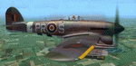
This folder contains a repaint for the Aerplane Heaven Hawker Typhoon in the colors of Typhoon JP975 as it may have looked on the 19th of August 1944, when it crashed near Saint-Maclou-la-Brière, a small village near Le Havre. JP975 was piloted by pilot Officer James Stellin RNZAF, who was flying with 609 squadron, based in Thorney Island airfield. On the 19th of August, 609 had been attacking the Falaise pocket when James Stellin was probably hit by flak while attacking ground targets. He tried to fly back to England, but was losing altitude and on realising he was probably going to crash in the middle of the village, managed to divert to crash at the last moment. He jumped from his aircraft, but was too low and his chute did not open. He was buried by the thankful civilians, who celebrated his sacrifice each year and have named the square in front of the church 'Place Stellin'. More on the last mission by Pilot Officer Stellin can be found here: https://nzhistory.govt.nz/page/kiwi-pilots-sacrifice-saves-french-village. It is not known what the aircraft code of JP975 was on the day of the crash, so I have opted for PR-S, for Stellin. Repaint by Jan Kees Blom, based on the paintkit by Aeroplane Heaven.
| Filename: | Hawker_Typhoon_JP975_RAF_609_Sqn_PRS.zip |
| License: | Freeware |
| Added: | 16th July 2018, 16:40:52 |
| Downloads: | 67 |
| Author: | Jan Kees Blom |
| Size: | 9.14 MB |
| Category: Flight Simulator X - Aircraft Repaints, Textures and Modifications | |
| Beech D18S repaint 6-pack |
|
Images related to this file:
File Description:
FSX Beech D18S. Six repaints for the Shupe/Thomas/Folkers
Beech D18S, which you must have previously installed in FSX.
I fly the version modified for FSX SP2/ACC by Dave Carroll,
but I'll bet these textures will work with most other Shupe
Beech 18's as well, so give them a try and see! These 18's
are fresh from the restoration shop, sporting new paint in a
variety of colors and a newly remodeled earth tone tan interior,
which will nicely match any exterior paint schemes on these or
any other Shupe Beech 18's you may already have in your hangar.
There are no registration numbers or
corporate/airline/charter/freighter/military markings, so you
are free to add whatever markings you wish in order to customize
your own personal Beech 18. If you enjoy using your 'DXTBmp'
program and your computer's default 'MS Paint' program
(or any paint program you prefer), you can quickly and easily
add your own registration numbers, and other markings,
or whatever else pleases you! Those of you who fly online in
FSX Acceleration could customize your own Beech 18's and have
a fly-in to show them off. Don't feel like finishing the paint
details? That's cool, as you can also fly them as is if you wish,
with no numbers or markings at all, as they look kinda pretty
in just their new paint against a sunny blue sky! Includes a
new shared 'texture' folder, which replaces the original
very blue cabin interior with a new earth tone tan colored interior,
to better match all of your Beech 18's exterior paints. Also includes
an FSX compatible engine smoke effect. Have fun! Easy installation.
By Tom Tiedman
| Filename: | Beech_D18S_repaint_6pack.zip |
| License: | Freeware |
| Added: | 6th October 2010, 00:08:11 |
| Downloads: | 355 |
| Author: | Tom Tiedman |
| Size: | 59.58 MB |
| Category: Flight Simulator X - Scenery | |
| US Navy Collection, with Flyable UAV |
|
Images related to this file:
File Description:

Unfortunately the Navy has cancelled or scaled down most fleet week celebrations around the nation. With this collection, you can stage your own!
Among the latest and hottest additions to the US Navy arsenal is the LCS. Two versions have been developed, the trimaran corvette by General Dynamics and Lockheed Martin's version, which promise to give a double black eye to Al Qaida, Somali pirates, or anyone else that opposes Freedom and Independence. Also are included in this package are the Arleigh-Burke class destroyer USS Fitzgerald, the Ticonderoga class cruiser Lake Champlain and two Oliver-Perry class frigates, FFG-58 Samuel B Roberts and FFG-60 Rodney M Davis. The centerpiece of the fleet is LHD-2 USS Essex and thanks to Arno's fantastic ModelConverterX, Essex is able to feature a highly detailed deck packed with 7 F-35b JSF, 6 MV-22 Osprey, 5 CH-53 and 2 Seahawks. Finally, SSN775 Texas, as part of the collection is available for patrol. All ships have landable decks, night lights and animation effects. Texas as a submarine is more of a boat, I believe, but it has navigation lights and wake effects.
I have also included another hot Navy addition, the RQ-8 fire Scout. There are two versions, a static RQ-8b lashed to the deck of Independence and an RQ-8c with the Flir Brite Star electro/optical turret which I have made flyable, largely for absence of deck space to place it as static.
Make no mistake that the Essex model is very resource intensive, with all it's polygons and what have you. The night lighting is stunning (imo) but seems to have an even heavier effect, you've been warned..
| Filename: | US_Navy_Collection_with_Flyable_UAV.zip |
| License: | Freeware, limited distribution |
| Added: | 19th October 2013, 20:27:36 |
| Downloads: | 1,291 |
| Author: | Rick Keller |
| Size: | 96.89 MB |
| Category: Flight Simulator X - Original Aircraft | |
| Mirage F.1CG Hellenic Air Force |
|
File Description:
On 16 June 1974 the contract for 40 Mirage F.1CG.s was signed and the deliveries were scheduled to last from 1977 until 1979. Because of the invasion of Cyprus by Turkey, in July 1974, the Mirages delivered on 5 August 1975. The Greek F.1CGs aircraft entered service with the 342 Mira, which at the time was still using the F-102A Delta Dart as an all-weather interceptor. The last Delta Daggers in HAF service would be retired in 1977 when all 40 F.1CGs were delivered. Unfortunately the Hellenic Air Force Staff did not buy any of the French AA missiles to equip the new fighters and so these had to be armed with US-supplied AIM-9Js instead. In 1984 the KETA (Center for Research and Aviation Technology) stared to develop the wiring for the 2 outboard underwing pylons, in order to make F.1Cgs able to carry 4 AAM instead of 2. This happened with Dassault's help by 1985 and ever since the PA Mirage tooth four AIM-9P-2. After the arrival of more modern types in PA service, the Mirage E.1CG's started to become secondary in PA planning and air operations. In 2000 344 Mira disbanded and all it’s aircraft and personnel passed on to 342 Mira. After almost 28 years of service, on 30 June 2003 the remaining 24 F.1CG's were retired at Tanagra AB. In total, the PA logged no less but 160.000+ flying hours with its F.1CGs, which means 5500-6000 per airframe - and many of these - over 3.500+ hours - in "live" interceptions over the Aegean Sea, under combat-similar conditions. Features: panel, Virtual Cockpit, four Textures, Sounds, msonic boom effect, reworked and more accurate flight dynamics.
| Filename: | Mirage_F1CG_Hellenic_Air_Force.zip |
| License: | Freeware |
| Added: | 26th June 2007, 10:53:15 |
| Downloads: | 34,745 |
| Author: | Thanasis Delizisis, Panagiotis Delizisis, Kirk Olsson |
| Size: | 33.76 MB |
| Category: Flight Simulator 2004 - Aircraft Repaints, Textures and Modifications | |
| NHL "Pittsburgh Penguins" Beechcraft Twin Bonanza" |
|
File Description:
Simmers,and Hockey fans,
This aircraft includes my NEW Twin Bonanza Panel_ V3, and for you FSX users it also includes "Camera Definitions" so ***BE SURE YOU COPY aircraft.cfg file to your main Twinstar_ Twin_ Bonanza folder.NOTE!(Camera Definitions will have no effect in FS9)***These 1951 D Model Beechcraft Twin Bonanzas are pristine,no dirt,grease or oil leaks on these babies!Just fresh out of the paint booth, these are the 24th repaint of my in progress NHL collection.All repaints are of "Eric Dantes" Beechcraft Twin Bonanza. All NHL teams will be represented.These repaints are not layered so each one has to be redrawn in its official colors.All repaints will have two liveries,one with team logos and one without logos.All NHL team names were put in two hats, Eastern Conference and Western Conference, they are drawn one from each hat at random.The next repaint will be the San Jose Sharks.(Look for it soon. :)I hope you have as much fun collecting all 30 liveries as I will have painting them!
This file includes the texture.Penguins"(The Pittsburgh Penguins Edition)",texture.NHL Pittsburgh,
"(The NHL Pittsburgh Edition....NOLOGOS)",panel.Penguins and the panel.NHL Pittsburgh folders and the aircraft.cfg file.It also includes two files to correct the knee board,they are the beech_baron_58_check.htm and the beech_baron_58_ref.htm,just copy these two files to your main Twinstar_ Twin_ Bonanza folder.
The following additional file is required.--------------twinstar__twin__bonanza.zip--------------
This file can be downloaded @ http://www.avsim.com/
Go to the file library and just use the Quick Search: type: Chris Tuinstra and you should see the twinstar__twin__bonanza.zip,along with my other NHL and NFL repaints.Again I thank each of you for your downloads.
This file includes a complete matching interior for both liveries".
| Filename: | NHL_Pittsburgh_Penguins_Beechcraft_Twin_Bonanza.zip |
| License: | Freeware |
| Added: | 11th May 2008, 12:37:49 |
| Downloads: | 261 |
| Author: | Chris Tuinstra |
| Size: | 10.38 MB |
| Category: Flight Simulator 2004 - Aircraft Repaints, Textures and Modifications | |
| NHL "Chicago Blackhawks" Beechcraft Twin Bonanza" |
|
File Description:
Simmers,and Hockey fans,
This aircraft includes my Twin Bonanza Panel_ V3, and for you FSX users it also includes "Camera Definitions" so ***BE SURE YOU COPY aircraft.cfg file to your main Twinstar_ Twin_ Bonanza folder.NOTE!(Camera Definitions will have no effect in FS9)***These 1951 D Model Beechcraft Twin Bonanzas are pristine,no dirt,grease or oil leaks on these babies!Just fresh out of the paint booth, these are the 27th repaint of my in progress NHL collection.All repaints are of "Eric Dantes" Beechcraft Twin Bonanza. All NHL teams will be represented.These repaints are not layered so each one has to be redrawn in its offical colors.All repaints will have two liveries,one with team logos and one without logos.All NHL team names were put in two hats, Eastern Conference and Western Conference, they are drawn one from each hat at random.The next repaint will be the Washington Capitals .(Look for it soon. :)I hope you have as much fun collecting all 30 liveries as I will have painting them!
This file includes the texture.Blackhawks"(The Chicago Blackhawks Edition)",texture.NHL Chicago,
"(The NHL Chicago Edition....NOLOGOS)",panel.Blackhawks and the panel.NHL Chicago folders and the aircraft.cfg file.It also includes two files to correct the kneeboard,they are the beech_baron_58_check.htm and the beech_baron_58_ref.htm,just copy these two files to your main Twinstar_ Twin_ Bonanza folder.
The following additional file is required.--------------twinstar__twin__bonanza.zip--------------
This file can be downloaded @ http://www.avsim.com/
Go to the file library and just use the Quick Search: type: Chris Tuinstra and you should see the twinstar__twin__bonanza.zip,along with my other NHL and NFL repaints.Again I thank each of you for your downloads.
This file includes a complete matching interior for both liveries".
| Filename: | NHL_Chicago_Blackhawks_Beechcraft_Twin_Bonanza.zip |
| License: | Freeware |
| Added: | 15th June 2008, 14:52:59 |
| Downloads: | 246 |
| Author: | Chris Tuinstra |
| Size: | 6.75 MB |
| Category: Flight Simulator X - Sounds | |
| Boeing 737NG CFM56-7B Ultra Effects Edition |
|
File Description:
SkyHigh Audio Simulations is proud to present what is quite possibly the most realistic sounding Boeing 737NG sound pack available! This sound pack is designed specifically for the PMDG 737NGX, and will not work properly in any other 737NG aircraft add-ons in MS FSX, or Prepar3D. Seperate 737NG versions for the freeware TDS, Vistaliners/Kittyhawk, default 737-800, and other 737NG add-ons will follow shortly.
We have gone through great lengths to make this sound as realistic as possible through all stages of flight and through all dimensions of the exterior view, as well as the interior points of view. These sounds will raise the bar for all future jet sounds for Flight Simulator X!
One new and amazing feature in this sound is the interior 3D Sound Cone environment specifically for the PMDG 737NGX version. The sound environment will change inside as you 'scroll' back towards the engines and wings in the 3D interior view (virtual cockpit view).
Perhaps the best part of these sounds is the exterior fly-by! Using 3D Sound Cone technology, there are two exterior buzzsaw sounds, one distant and one up close. Two jet whine sounds, one for front and rear, and one for side-on to the plane. There are three powerful sounding rumble/exhaust sounds, one 'whooshing' sound effect for side one, one powerful blast sound for behind the engine, and one low rumble for when the plane is flying overhead at a distance. All in all, this will create one of the most realistic sounding in-game jet fly-by sound experiences for Flight Simulator X, especially for the CFM56-7B 737NG in FSX.
We hope you enjoy these new ultra-realistic 737NGX sounds for FSX. Actually we know you will enjoy them!
| Filename: | Boeing_737NG_CFM567B_Ultra_Effects_Edition.zip |
| License: | Freeware |
| Added: | 8th December 2014, 12:03:20 |
| Downloads: | 15,496 |
| Author: | Adam Murphy and Jesse Casserly - Skyhigh Audio Simulations |
| Size: | 79.16 MB |


© 2001-2026 AVSIM Online
All Rights Reserved
Privacy Policy |