
Where Flight Simulation Enthusiasts Gather from Around the World!
AVSIM Library - Search Results

| Category: Flight Simulator X - Scenery | |
| Freeware Project Kobe X (RJBE) Japan |

|
Images related to this file:
File Description:
Freeware project KOBE X (RJBE) Japan. Contains fully detailed airport with custom ground polygons. Accurate 3d model and texture of all the building of the airport including the terminal, control tower, hangars, bridge and many more. Please note that this project was my initial experience in many fields of scenery design so take it as it is and enjoy flying in Japan. The design is never done but I think it was ready to be released. Still have some work to do with the animated jetways and night lighting for my next "payware" project (KSAN, San Diego Intl). It's going to be far better than this freeware.
You can download the world of ai installer and install the All Nippon Airways package and maybe the JAL too. The jetways are not animated but you can park a 747 in gate 1, a 767 in gate 5 and a 737 in gate 6 and be perfectly aligned with the jetway door.
Also I've not try this scenery in a less powerful computer than mine. I run a Windows 7, I7-950 @ 3.8 GHz and a GTX 570. So don't get mad if you're having bad performances :). With all sliders in the "display settings" set to max I've around 20 fps in the virtual cockpit of the level-d 767. You'll get a nicer airport with also the global texture resolution set to max, water effects set to High 2.x and traffic to ultra-high. Do not turn on Ground scenery shadows as it will make a shadow for the entire airport (ground poly).
I've some tutorial on my YouTube channel (n170toga) on how to make fsx sceneries if you are interested. Don't forget to subscribe there and have updates for the upcoming scenery. Please review this airport if you like as I will learn a lot for my next
project and it's only going to be better.
This scenery is a freeware and should be considered as a freeware. Arigato, Sagga Toure (Devinci), Devinci Design and Development (3De)
| Filename: | Freeware_Project_Kobe_X_RJBE_Japan.zip |
| License: | Freeware |
| Added: | 12th June 2011, 08:28:51 |
| Downloads: | 6,656 |
| Author: | Sagga Toure |
| Size: | 66.48 MB |
| Category: Flight Simulator X - Scenery | |
| Mesolonghi Airport - Rio-Antirio Bridge - Greece ** UPDATED VERSION ** |
|
Images related to this file:
File Description:
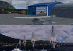
These are actually two sceneries offered in one pack. I started building the small airport of Mesolonghi in Western Greece. When nearing completion, I thought that FS was really missing the big suspension Bridge that connects mainland Greece with Peloponese that was finished in 2004, being the biggest in the world of the fully suspended type. The bridge project turned out bigger than the airport as I ended up doing the typical, Greek-style double ended ferries that served the straights for decades before the bridge and still offer a cheaper and, to some, more relaxing alternative.
Mesolonghi airport is situated 5 kilometers east of the historic city of Mesolonghi and is close to the technical school of fisheries. There is no ICAO code (ZZZZ) so I had to give it the fictional LGME in the sim. A purely day field, it houses the local Aeroclub and ultralight school. due to its small size and hospitable atmoshpere, it is a popular GA pilots destination, receiving also often international arrivals. The runway is asphalt and 800m (2635') in length. No PAPI or VASI are provided. There is no tower service and unicom frequency of 119.7MHz is used by the traffic. Closest controlled airport is Araxos (LGRX), a civil and military field, quite common in Greece, 12.5 nautical miles S-SE. The nearby city of Mesolonghi is famous for its heroic resistance and fall in 1826 during the Greek war of indepence. It is also famous for its fishery production, due to the natural lagoon, formed by the shallow waters.
Features of the Mesolonghi airport scenery include:
- Photoreal area with seasonal variations and watermask.
- Custom hangars and containerised buidings.
- AI default trike performing TnGs (in P3D it will work only if you copy over the FSX trike).
- The technical shool of fisheries on the north side.
- Customized shorelines, to fit with ORBX Global Vector.
- Optional shoreline fix for default scenery.
The Rio-Antirio bridge is located 14.5 nautical miles to the east of the airport. It connects the towns of Rio on the south side and Antirio on the north side. More data on the bridge can be found on Wikipedia.
Features of the Rio-Antirio bridge scenery include:
- Custom bridge model, bump mapped textures with hard platform surface and vehicle traffic.
- Night lighting textures and custom roadlights.
- Photoreal scenery for north and south shores, including hand placed autogen and night textures.
- Custom castle models on north and south sides, with bump mapped textures and night lighting.
- Custom model of the toll post on the north side.
- Custom AI ferry boats with constant shuttle service between Rio and Antirion piers.
- Customized shorelines, to fit with ORBX Global Vector.
- Optional shoreline fix for default scenery.
- Optional HDR optimized photoreal textures.
| Filename: | Mesolonghi_Airport__RioAntirio_Bridge__Greece___UP.zip |
| License: | Freeware |
| Added: | 16th March 2016, 09:15:21 |
| Downloads: | 2,627 |
| Author: | Vassilios Dimoulas |
| Size: | 300.05 MB |
| Category: X-Plane - Original Aircraft | |
| B17 Flying Fortress |
|
File Description:
The B17 is arguably the best known heavy bomber from WWII. Followed closely by it's direct successor the B29 SuperFortress it symbolizes the best of WWII's heavy Bombers. The B17 was one of the planes that barely made it into the war. In 1934 the then very small Boeing company had a prototype four engined bomber design called the B-299 but it had not been ordered by the US military. It had suffered several serious setbacks in it's design competition including a crash during a fly-off. Boeing continued work the plane and eventually secured a small service test order and the troubled early history of the bomber began.
The B17 and bombers like it were planes created as "strategic bombers". The essential idea was that a strategic bomber should be able to carry a very large payload for long distances. The military had come to the realization that bombing technology was by nature imprecise even with new advances like the American Norden sight, and what was required was a large number of bombs delivered by large number of planes to assure that a target was destroyed. Although the Germans actually had a decent "smart bomb" and the British built specialty bombs, neither was reliable, so it seemed the best idea was just to blanket the target with bombs.
An American extension to this concept was that of a self-defended bomber. Bombers could be built so tough and with so much defensive armament, it was thought, that they could simply fly to the target, drop bombs, and if necessary fight their way through fighters to get home. There would be security in the large number of bombers in formations, and the defensive capability would allow bombers to fly during the day for better accuracy in drops. It was to this design concept the B17 was built.
Early experiences in the war with B17's and B-24's could only be termed as disastrous. Loss rates of up to 25% showed the concept of unescorted bombers in daytime to be entirely wrong. Escort fighters were a necessity for success. It soon became apparent that with fighter cover the B17 really was an unparalleled strategic bomber. Success for the B17 shot up dramatically, and it's initial design specifications of huge amounts of armor and gunner positions served it well when fighters did make it close in. The Fortress had enough strength to stave off attackers until escorts showed up, and it became legendary for the incredible punishment it could take and still make it home.
Boeing B-17F Flying Fortress
Wingspan: 103 ft. 9 in.
Length: 74 ft. 9 in.
Height: 19 ft. 1 in.
Engine: 4 x Wright R-1820-97 Cyclone rated 1,200 hp.
Loaded Weight: 65,500 lb.
Maximum Speed: 287 mph.
Service Ceiling: 37,500 ft.
Combat Radius: 1,000 miles
Armaments: 6,000 lbs. of bombs, 12 x .50 cal. machine guns
| Filename: | B17_Flying_Fortress.zip |
| License: | Freeware |
| Added: | 23rd March 2003, 15:42:16 |
| Downloads: | 3,544 |
| Author: | Robert App |
| Size: | 761.49 KB |
| Category: Flight Simulator 2004 - Scenery | |
| KSNA, John Wayne-Orange County Airport |
|
Images related to this file:
File Description:

John Wayne Airport (IATA: SNA, ICAO: KSNA, FAA LID: SNA) is an airport in an unincorporated area in Orange County, California, with its mailing address in the city of Santa Ana, which is also the county seat, hence the International Air Transport Association (IATA) airport code. The main entrance to the airport is off of MacArthur Blvd in Irvine, the city that abuts the airport from the north and east. Newport Beach and Costa Mesa form the southern and western boundaries, respectively, together with a small unincorporated area along the Corona del Mar (73) Freeway. Santa Ana lies just north, not actually touching the airport directly. Originally named Orange County Airport, the county Board of Supervisors renamed it in 1979 to honor the actor John Wayne, who resided in neighboring Newport Beach and died that year. It also became the first airport to be named after an entertainer.
The main runway, at 5,701 feet (1,738 m), is one of the shortest of any major airport in the United States, resulting in most passenger aircraft operating from the airport to be no larger than the Boeing 757. However, some larger cargo aircraft, such as the FedEx A310/300, fly from SNA. Some gates are built to handle planes up to the size of a Boeing 767, which can operate with payload/fuel load restrictions. No wide-body passenger aircraft are currently in scheduled service at the airport.
| Filename: | KSNA_John_WayneOrange_County_Airport.zip |
| License: | Freeware, limited distribution |
| Added: | 11th October 2011, 04:03:32 |
| Downloads: | 4,878 |
| Author: | Mateusz Stabryla MK-Studios |
| Size: | 59.73 MB |
| Category: Flight Simulator X - Scenery | |
| KSNA, John Wayne-Orange County Airport |
|
Images related to this file:
File Description:

John Wayne Airport (IATA: SNA, ICAO: KSNA, FAA LID: SNA) is an airport in an unincorporated area in Orange County, California, with its mailing address in the city of Santa Ana, which is also the county seat, hence the International Air Transport Association (IATA) airport code. The main entrance to the airport is off of MacArthur Blvd in Irvine, the city that abuts the airport from the north and east. Newport Beach and Costa Mesa form the southern and western boundaries, respectively, together with a small unincorporated area along the Corona del Mar (73) Freeway. Santa Ana lies just north, not actually touching the airport directly. Originally named Orange County Airport, the county Board of Supervisors renamed it in 1979 to honor the actor John Wayne, who resided in neighboring Newport Beach and died that year. It also became the first airport to be named after an entertainer.
The main runway, at 5,701 feet (1,738 m), is one of the shortest of any major airport in the United States, resulting in most passenger aircraft operating from the airport to be no larger than the Boeing 757. However, some larger cargo aircraft, such as the FedEx A310/300, fly from SNA. Some gates are built to handle planes up to the size of a Boeing 767, which can operate with payload/fuel load restrictions. No wide-body passenger aircraft are currently in scheduled service at the airport.
| Filename: | KSNA_John_WayneOrange_County_Airport.zip |
| License: | Freeware, limited distribution |
| Added: | 11th October 2011, 08:25:20 |
| Downloads: | 11,006 |
| Author: | Mateusz Stabryla MK-Studios |
| Size: | 66.92 MB |
| Category: Flight Simulator X - AFCAD Files | |
| Cross Keys Airport (17N), NJ |
|
File Description:
Located 01 miles S of Cross Keys, New Jersey on 280 acres of land, Cross Keys Airport is a small General Aviation field privately owned by Cross Keys Airport Inc. In addition to servicing GA flights, the airport also hosts a paintball field and a sky diving operation to the north of the field. For this reason, all aircraft must remain south of the runway at all times. Any aircraft with a wingspan larger than 40 feet will need to park in the turf area west of the main apron - smaller GA aircraft can pick a spot from any of the open tiedown areas. 100LL (Blue) Fuel is available by stopping next to the fuel tank on the main apron. Although it doesn't exist in real life, a patch of concrete to the west of the main apron made for a good helipad, so I included one. It is not lit at night. Trees in the surrounding forest are summer trees ONLY.
Scenery constructed with use of Google Maps images, and vague recollection by the author who went sky diving there once.
This scenery is meant to be used in conjunction with MegaScenery Earth New Jersey/Delaware 004. It is not required, but apron use is minimized to allow satellite scenery to show through as much as possible, and objects are placed based on the MSE textures - lack of it may make scenery look out of place.
| Filename: | Cross_Keys_Airport_17N_NJ.zip |
| License: | Freeware |
| Added: | 7th October 2010, 03:27:53 |
| Downloads: | 246 |
| Author: | Drew Sikora |
| Size: | 719.13 KB |
| Category: Flight Simulator 2004 - Scenery | |
| Aasiaat BGAA on the west coast of Greenland |
|
Images related to this file:
File Description:
I wrote that Qikiqtarjuaq, on the east coast of Baffin Island, was the jumping off airfield for ferry flights for small planes from Canada to Europe via Greenland. Aasiaat is the airfield in Greenland that they jump to, 300 miles across the Davis Strait. The airfield is on the northern coast of Aasiaat Island, and the town of the same name is just two miles to the west. The runway is 2,600 feet of asphalt almost 100 feet wide and lit, at 74 feet ASL, aligned 12/30, with the apron and terminal building at the western end. Air Greenland run regular flights with a Dash-7 or 8, & Twin Otters, and the markings for the taxiway and parking spot in front of the terminal are exactly as they were six years ago. I have seen video since then that has further taxiway and parking spot markings added in, but I like the simplicity of the original. Unfortunately, given the limitations of FS and the single runway and simple taxiway routing there was no way to replicate both the parking facing away from the terminal AND the "through" taxiing to complete the circle back to the runway; after parking correctly the AI Air Greenland Dash-8 will reverse before heading out to take off. There is both JetA and 100LL fuel available. The surrounding area is rocky, and there is no grass around the runway; the airfield has compacted gravel instead.
| Filename: | Aasiaat_BGAA_on_the_west_coast_of_Greenland.zip |
| License: | Freeware, limited distribution |
| Added: | 26th March 2012, 11:01:16 |
| Downloads: | 691 |
| Author: | Roger Wensley |
| Size: | 2.73 MB |
| Category: Flight Simulator 2004 - Scenery | |
| Kugaaruk CYBB and DEW Pelly Bay CWPB in Nunavut, Canada |
|
Images related to this file:
File Description:
Kugaaruk is on the coast of northern mainland Canada on the Boothia Peninsula, 60 miles into a deep north-south fjord-like inlet called Pelly Bay. The name was changed from Pelly Bay in 1999, and the population is around 800. Gjoa Haven is 150 miles to the west, and Hall Beach just over 200 miles to the east. Six miles south of the village, and connected by a gravel road, there is a NWS station and what remains of a DEW Auxiliary Site; the DEW site was closed in 1992, a year after the NWS station became operational. There is also a 3,350 feet long gravel runway beside Barrow Lake 2 miles east of the site, Pelly Bay CWPB. Kugaaruk airfield is adjacent to the village and the 5,000 feet of 100 feet wide gravel runway is aligned 049T/229T where T stands for "true" as opposed to magnetic. There are flights by First Air and Canadian North and the AI includes a daily flight of each from Yellowknife via Gjoa Haven (as per real life) plus a cargo visit by Buffalo. Although the runway is long enough to accomodate a 737 it is not licensed for regular scheduled jet flights; the reason for this is that the approach lighting is "inadequate". Included here is a new .bgl for Gjoa Haven which will remove the small hold short line from the gravel; my mistake.
| Filename: | Kugaaruk_CYBB_and_DEW_Pelly_Bay_CWPB_in_Nunavut_Ca.zip |
| License: | Freeware, limited distribution |
| Added: | 25th November 2012, 00:43:07 |
| Downloads: | 429 |
| Author: | Roger Wensley |
| Size: | 6.1 MB |
| Category: Flight Simulator X - Aircraft Repaints, Textures and Modifications | |
| FSX Grumman F9F RNLN VSQ860 LATE |
|
Images related to this file:
File Description:
This livery represents a fictional "What if" repaint of the magnificent payware Grumman F9F-5 by VertigoStudios in a Royal Netherlands Navy Livery.
The aircraft resembles what it would look like if the Dutch government chose the Grumman F9F Panther over the Hawker Seahawk as their primary
attack fighter operating from the sole Dutch Navy aircraft carrier from the late 40-ies till the early 60-ies; the HRMS Karel Doorman (CV, R81,
Colossus Class). The Dutch navy operated two other aircraft carriers prior to this one (small MAC escort carriers, which were basically modified tankers),
but the R81 was the first and only real aircraft carrier ever operational within the Royal Netherlands Navy, and to operate jet-fighters from.
This particular livery of the F9F is in a typical grey & duck-egg green pattern resembling all Dutch naval aircraft of that era, carrier- and land based.
This livery with the "D" marking denotes the aircraft has the CV R81 "Karel Doorman" as home base.
Aircraft similar in operation and colour at that time (actually the Hawker Seahawk-era) were: Sikorsky S55, Grumman TBM 3S2/3W2 Avenger later
added/replaced with the Grumman S-2A Tracker and the Sikorsky S58. In the final stages of Dutch aircraft-carrier operations the role of the
HRMS Karel Doorman was reduced to an "Anti-Submarine Warfare" carrier. You need the payware VertigoStudios F9F for FSX in order to use this repaint.
| Filename: | FSX_Grumman_F9F_RNLN_VSQ860_LATE.zip |
| License: | Freeware |
| Added: | 11th January 2011, 08:31:58 |
| Downloads: | 161 |
| Author: | Rene Spaan |
| Size: | 7.51 MB |
| Category: Prepar3D V1-4 - Scenery | |
| Mount Diablo Summit Museum |
|
Images related to this file:
File Description:
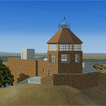
The museum and visitor center house a diorama of the parks ecosystems, complete with the sounds found in nature, and a topographic model of the mountain. On one wall, an instructional video and lighted display case describes the geologic forces that created the mountain. On anther wall, cultural history is chronicled with splendid photographs. The lower level of the summit building contains panels describing the Native American history of the region and an audio-visual room. Rotating displays of art and photography complement the permanent exhibits. In addition to the exhibits, there is a small gift center within the building.
| Filename: | Mount_Diablo_Summit_Museum.zip |
| License: | Freeware, limited distribution |
| Added: | 13th June 2016, 20:46:13 |
| Downloads: | 185 |
| Author: | Rick Keller |
| Size: | 1.08 MB |


© 2001-2026 AVSIM Online
All Rights Reserved
Privacy Policy |