
Where Flight Simulation Enthusiasts Gather from Around the World!
AVSIM Library - Search Results

| Category: Flight Simulator 2004 - Scenery | |
| Ford-Timor (Jump Ramp Heaven) |

|
Images related to this file:
File Description:
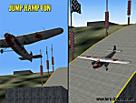
6 different layers in one pack. This scenery pack is a fun experiment in Jump Ramp development - to get aircraft to launch into the air.
Many different angles and many different challenges for your fun flying pleasure.
Contains lots of small and large Jump Ramps, a couple of Ski Ramps and a Grass up/down Hill Runway.
Also contains an Aircraft Carrier with two jump ramps and an Airship with a runway and jump ramp on top.
All set up on 6 different height levels - absolute fun flying and some great challenges for takeoff and landings.
BONUS AIRFIELDS
For those that already have Ford-Blackhawk, Ford-Brazil and Ford-Switzerland installed - a collection of files are included in the Ford-Timor project that will add ramps and jumps to these packages.
Slideshow to show you what is included:
http://www.ford-tri-motor.net/Slideshows/JUMP_RAMP_HEAVEN.html
| Filename: | FordTimor_Jump_Ramp_Heaven.zip |
| License: | Freeware, limited distribution |
| Added: | 16th July 2016, 14:34:48 |
| Downloads: | 80 |
| Author: | Garry J. Smith - Ford Project Team |
| Size: | 3.91 MB |
| Category: Flight Simulator 2002 - Scenery | |
| Aleutian Islands Scenery Enhancement - Part I |
|
File Description:
This scenery enhances the Aleutian Islands in Alaska. Over 80 small, individual
scenery areas have been added to the Aleutians to provide VFR landmarks while
flying this area with World Aeronautical Charts. (WAC)
All cabin and building markers from WAC charts CE-12 and CE-13 are present in
the scenery. It consists mostly of cabins which are spread out through the Aleutians.
Unalaska has been completely enhanced, adding the city, ships, and docks to the default airport. Some floatbases (not covered by Dave's scenery) in the Aleutians now have corresponding cabins and wood docks around them.
This scenery is fully compatible with Dave Erickson's "Alaskan Docks 2" scenery,
and is HIGHLY recommended, as I did not touch any of the areas which are covered by that scenery, except for Unalaska, for which I used a city map to recreate and upgrade. Details in the readme.
| Filename: | Aleutian_Islands_Scenery_Enhancement__Part_I.zip |
| License: | Freeware |
| Added: | 18th November 2002, 04:06:24 |
| Downloads: | 2,911 |
| Author: | Jorge 'eko' Salas |
| Size: | 6.13 MB |
| Category: Civil Flight Simulators - Looking Glass Flight Unlimited 3 | |
| High Resolution Region Builder Tool for Elevation |
|
File Description:
GeoTilesViewer25.zip: NEW Version 2.5 11.dec.2002. You will need this tool to apply changes at the elevation structure of a fu3 region. This new version can handle very large region as UK-South.
There are elevation modification uploads on the way for the UK-South region.
To load this updates you will need this tool. The full geotiles.tag file
has 92MB and upload of such a file is not possible. An elevation update needs just 200k
for 1 megatile so it is better to use this tool and the small update files.
You can explore and modify elevation and classification using this tool by
first exporting a map, painting a map with your paint program and then
importing it again. This is an experimental tool and still under construction.
New in Version 2.5 are large region handling, generation of color scale files
an scripts for unattended multiple imports.
| Filename: | High_Resolution_Region_Builder_Tool_for_Elevation.zip |
| License: | Freeware, limited distribution |
| Added: | 12th December 2002, 00:14:20 |
| Downloads: | 196 |
| Author: | André Meystre |
| Size: | 147.14 KB |
| Category: Flight Simulator 2002 - Gauges | |
| AFG Heads Up Guidance System Version 2.0 |
|
File Description:
FS2002 Heads Up Guidance System. This photo realistic HUD is based on a real world
HUD used in 737s and regional jets. It's the second version of the award winning AFG HGS v1 which was first true heads up guidance system for MSFS
because it can be used by itself for all phases of flight and has special modes for
instrument and visual approaches. There is a flight path vector and a guidance cue that can
command a change in flight path as small as .04 degrees. Panel.cfgs for DreamFleet's 734,
project magenta and some of the default panels, along with a pdf manual are included. New features include autoland (without default FS2002 approach guidance) which solves the infamous glide slope capture problem. The code has been rewritten so there are much faster frame rates, more accurate guidance, more accurate flight path vectoring and more.
| Filename: | AFG_Heads_Up_Guidance_System_Version_20.zip |
| License: | Freeware, limited distribution |
| Added: | 1st August 2002, 21:32:35 |
| Downloads: | 10,872 |
| Author: | Jon Gibbs |
| Size: | 1.64 MB |
| Category: Flight Simulator 2002 - Miscellaneous Files | |
| Los Angeles Terminal Area Chart |
|
File Description:
The rendition of Los Angeles´ KLAX airport is one of the most detailed in FS2002 and a great starting point to explore the West Coast. The library hosts a few awesome landclass and mesh files for this area that offer an "as real as it gets" VFR experience if used with this chart. The 1:250.000 scaled chart is scanned in high resolution (8400*4700 pixel). It covers a much smaller area, but offers considerably more detail than the LA sectional. You may use this chart "as is" without any other software, but it will develop its full potential if used as moving map with SimSystem´s FSFlightMax or FSGarmin. It wouldn´t have been possible to offer this chart without Richard Harvey and his love to flightsimming, so please consider this file to be "donationware" and make a however small contribution to the Richard Harvey Endowed Scholarship.
| Filename: | Los_Angeles_Terminal_Area_Chart.zip |
| License: | Check within download |
| Added: | 30th March 2003, 15:27:19 |
| Downloads: | 1,472 |
| Author: | Uwe Rademacher |
| Size: | 28.03 MB |
| Category: Flight Simulator 2002 - Scenery | |
| British Farm Strips: Eastbach, Milson, & Nayland |
|
File Description:
Three interesting small English farm strips. Nayland is in Suffolk, near Colchester - the main 600m grass strip has a gradient of 8% in its first half:
probably the closest you'll get in Britain to one of the French alpine runways like Courchevel or Megève. Milson is in rural Shropshire on the side of a shallow valley; it has both a helipad & a 450m grass strip - most of which is on a fairly gentle 3.5% slope apart from the last 70 feet which rises up more steeply. The two runways at Gloucestershire's Eastbach Farm, on the edge of the Forest of Dean, are also on a slight slope but most of the excitement comes from their short length (250m & 350m respectively) - ideal for microlights and STOL planes. All three airfields are compatible ONLY with LAGO's TerraMesh Part 13 of England & Wales - no other mesh will work.
| Filename: | British_Farm_Strips_Eastbach_Milson__Nayland.zip |
| License: | Freeware, limited distribution |
| Added: | 31st March 2003, 13:05:02 |
| Downloads: | 1,298 |
| Author: | James Belk |
| Size: | 2.73 MB |
| Category: Flight Simulator 2004 - Original Aircraft | |
| Piaggio P-166M |
|
File Description:
The first of the coming P-166 aircraft series. I'm going to built the whole family of these graceful twins.
The Piaggio P-166M is a light small twin. An Exotic two-engined prop that sold all over the world including America, UK, and Australia. Its origin is traced Back to the Piaggio P-136, a light anphibian, wich the P-166 keeps the wings, the engines and the tailplanes. The first P-166A flew in November 1957. The M version is built for Italian air forces, and the only difference stands in cabin arrangements. There are also different arrangements for the M version. The aircraft is still in production in a slightly modified turboprop version, the P-166D-P1. This model is 788 Kbs with c.a. 23000 polygons in c.a.170 assemblies. Features Clickable Dynamic VC with non-planar throttle quadrant. Detailed internals. Fully compatible with FS 2002 (pro edition)
| Filename: | Piaggio_P166M.zip |
| License: | Freeware |
| Added: | 19th October 2003, 22:45:41 |
| Downloads: | 4,520 |
| Author: | Mario Noriega |
| Size: | 5.8 MB |
| Category: Flight Simulator 2004 - Scenery Design | |
| TDFCalc2004 (Version 3) |
|
File Description:
This package is for FS2004 and FS2002 terrain designers. TDFCalc2004 is made for use with FSUIPC and FS2004. This is a version that includes true heading readings, and LOD8 Zone coordinates for VTP2 lines and polys. It is an FSUIPC registered freeware program that requires version 3.? of FSUIPC.dll installed to the FS2004 Module folder. FSUIPC is avaliable on the internet, and this program requires an application registration entered within FSUIPC. Usage with FS2002 or CFS2 requires no registration with the older versions of FSUIPC. LandCalc and TDFCalc2 are small programs which require the input of Latitude and Longitude, in 'DD:MM.decimal' format. Landcalc returns the names of the "CUSTOM" textures required by photoreal ( CUSTOM ) BGLs, and LandClass BGLs ( using values #253 or #252 ). TDFCalc2 returns valuable information concerning the X, Y coordinates needed for the creation of LWM and VTP polygons/lines. TMFViewerCalc requires input as Decimal Degrees.
| Filename: | TDFCalc2004_Version_3.zip |
| License: | Freeware |
| Added: | 5th October 2003, 18:48:15 |
| Downloads: | 1,324 |
| Author: | Richard Ludowise |
| Size: | 926.55 KB |
| Category: Flight Simulator 2004 - Scenery | |
| BFU Brooks |
|
File Description:
With BFU Brooks, BFU enters the faraway bush country of northern Alaska. Located at Coldfoot in the southern foothills of the Brooks mountains, this base will cater to the needs of visitors to the area, and of sportsmen who indulge in hunting and fishing. This scenery package consists of three sceneries: our new northern base BFU Brooks, Moose Camp and Moose Lodge. The camp sits in the mountains on a small lake, whereas the lodge is situated on the shore of a large lake. Visitors are flown into Coldfoot from Fairbanks, then on to the camp or lodge as desired. Moose Camp and Moose Lodge will not show on the GPS, and of course do not have an NDB or similar to guide you. You'd better start in the camp/lodge, and fly toward Coldfoot to get to know the area. The sceneries have only been tested with the default mesh.
| Filename: | BFU_Brooks.zip |
| License: | Freeware |
| Added: | 30th September 2003, 15:17:31 |
| Downloads: | 5,315 |
| Author: | Naji Chehabeddine |
| Size: | 2.96 MB |
| Category: Flight Simulator 2004 - Scenery | |
| Petaluma , California (O69) Scenery |
|
File Description:
This is a scenery upgrade for Petaluma Airport, California (O69). This is part Five of a series of small airstrip and minor airfield scenery enhancements which are based on real world data from Google Earth.
This is a more complex scenery than previous ones. You can see from the Google earth image that a golf course runs alongside the airport (appropriately called the Rabbit Run!). I have tried to include this with a golf course landclass polygon, also the airfield base seems mainly a red soil and this is reflected in the airbase poly. Built using EZ_Scenery, Lee Swordy's AFCAD and SBuilder. You must have rwy12 and EZ scenery libraries installed for the buildings to show. Both libraries of objects are free;
EZ Library is available from this URL http://www.abacuspub.com/pub/AbacusEZLibraries.exe
rwy12 from Avsim and additional EZ Custom libraries from Avsim. Search under Scenery design.
| Filename: | Petaluma__California_O69_Scenery.zip |
| License: | Freeware |
| Added: | 23rd March 2006, 23:09:07 |
| Downloads: | 719 |
| Author: | Kim Gowney |
| Size: | 629.87 KB |


© 2001-2026 AVSIM Online
All Rights Reserved
Privacy Policy |