
Where Flight Simulation Enthusiasts Gather from Around the World!
AVSIM Library - Search Results

| Category: Flight Simulator X - Miscellaneous Files | |
| State Capitals.zip |

|
File Description:
I have been using BAsys excellent Visit series in free flight and collected a large number.
But the USA just has too many airports for my lifetime.
Therefor I have created a set or rewards for state capitals and Washington DC.
Comprise a seal with the flag as detail for each state and one for the complete collection 52 in all.
I automated the creation of xml files, GUID generation etc by creating macros for excel 2007 and up.
create your XML file add the two images small and large and drag to BGLcomp.exe
and your reward is created.
Incidently the original fsx 2009 sizes of 100x80 and 300x370 is no longer a restriction that is found in old reward compilers. I use 100x100 for the small and upto nnnx370 for detail. nnn=upto 680
You can therefore use real holiday photos id you wish.
The folder that does this is also included in the attached State Capitals.zip
Unzip drop the folder US States into ..\fsx|rewards and start flying.
| Filename: | State_Capitalszip.zip |
| License: | Freeware |
| Added: | 25th February 2017, 07:17:58 |
| Downloads: | 138 |
| Author: | Brian Bean |
| Size: | 3.63 MB |
| Category: Prepar3D V1-4 - Scenery | |
| The island of Capraia N43.3.2 E9.50.13 and City |
|
File Description:
The island of Capraia N43.3.2 E9.50.13 is located in the Corsica Channel (arm of the sea on the border between the Ligurian Sea and the Tyrrhenian Sea), and is an island of volcanic origin, the third largest in the Tuscan Archipelago. It has high and rocky coasts with no beaches (sometimes in the Cala della Mortola there is a small sandy beach [5]) and a small lake basin (called Stagnone or Laghetto [6]) in the most mountainous area, with peaks along a central chain Anticamente called Aigylion Greeks and then Capraria from the Romans, the name derives from the presence of wild goats on the island, but according to another hypothesis the toponym derives from a Mediterranean theme * karpa with the meaning of «rock». It was certainly an Etruscan landing place like the other Tyrrhenian islands in the 7th century, becoming a pirate base when it was occupied by the Romans.Important VFR point for approaching fron Nord airport Isola d'Elba.
Within the downloaded package you will find readme files for scenery installation. Good fly VFR. Pasquale Marrulli.
| Filename: | The_island_of_Capraia_N4332_E95013_and_City.zip |
| License: | Freeware |
| Added: | 2nd January 2018, 17:31:32 |
| Downloads: | 154 |
| Author: | Pasquale Marrulli |
| Size: | 2.8 KB |
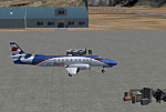
| Category: Flight Simulator 2004 - Aircraft Repaints, Textures and Modifications | |
| Paulistana Embraer ERJ-145LR |
|
File Description:
This repaint requires the previous instalation of Feelthere PIC ERJ-145LR payware model. It only works in MSFS2004. This is a repaint of Feelthere excellent ERJ-145LR model. It was painted in Paulistana Air Tour´s colors. Paulistana is a small fictional VA from Brazil.
Its main line of operation are short routes connecting Congonhas Airport, at São Paulo, to many small airports in the Southern states of Brazil. And that´s where our ERJ´s fit, together with our remaing Embraer 120 Brasília.
Come visit us at: http://paginas.terra.com.br/lazer/paulistana.
Essa repintura requer a prévia instalação do modelo pago Feelthere "PIC ERJ-145LR"
Só funciona no MSFS2004.
Esta é uma repintura do excelente modelo de um ERJ-145LR da Feelthere. Foi pintado nas cores da Paulistana Air Tour. Paulistana é uma pequena e fictícia VA brasileira.
Sua linha de operação principal são as pequenas rotas conectando Congonhas a diversos pequenos aeroportos no Sul/Sudeste brasileiros. Nessas rotas é que se encaixam nossos ERJ-145, juntamente com o nosso Brasília.
Visite-nos em: http://paginas.terra.com.br/lazer/paulistana
| Filename: | Paulistana_Embraer_ERJ145LR.zip |
| License: | Freeware, limited distribution |
| Added: | 20th December 2006, 21:11:17 |
| Downloads: | 439 |
| Author: | Carlos Alexandre Nader |
| Size: | 5.4 MB |
| Category: Flight Simulator 2004 - Scenery | |
| Funny Farm (4CA2) Brentwood, California Scenery |
|
File Description:
This is a scenery upgrade for Funny Farm Airport, Brentwood, California (4CA2) (Why Funny Farm?) This is part Nine of a series of small airstrip and minor airfield scenery enhancements which are based on real world data from Google Earth. The scenery mainly reflects the appearance of the airpark from directly above, so if you are familiar with the place then on the ground it probably looks quite different, due to the limited number of buildings available. This scenery includes the Private lake and dwellings to the southwest of the airstrip proper plus extensive landclass alterations to make the small paddocks in the same area. This is a tough place to land neatly in anything past a C172 in calm weather; the runway is only 20 feet wide! Built using EZ_Scenery, Lee Swordy's AFCAD and SBuilder. You must have rwy12 and EZ scenery libraries installed for the buildings to show. Both libraries of objects are free: EZ Library is available from http://www.abacuspub.com/pub/AbacusEZLibraries.exe and rwy12 and additional EZ Custom libraries from Avsim. Search under Scenery design.
| Filename: | Funny_Farm_4CA2_Brentwood_California_Scenery.zip |
| License: | Freeware |
| Added: | 1st April 2006, 23:42:42 |
| Downloads: | 547 |
| Author: | Kim Gowney |
| Size: | 359.43 KB |
| Category: Flight Simulator 2004 - AI Aircraft | |
| KR1 for AI |
|
File Description:
Ken Rand's small, single-seat, retractable-gear homebuilt, built using Styrofoam and Dynel/epoxy model aircraft techniques. This model was designed using FSDS v3.51, principally for ai use, so there is a relatively low polygon-count main model, with several LOD models and a reduced-detail shadow for optimal fps. Not a short-field aircraft, it's quite streamlined and there are no flaps, so the stall speed is quite high for a small 'plane, 45kts., but as it's such fun to fly I fitted a basic VC with a functional panel using mostly default gauges. This is a "slippery" little aircraft, needing rather more runway to land than you might expect, so line up early and get your speed down if you don't want to have to go around. The flight dynamics were prepared with Gerry Beckwith's AirWrench, but, as is the way with many homebuilt aircraft, the figures I worked from, hence my final result, will probably vary from other published data. Please see the enclosed text file for further details.
| Filename: | KR1_for_AI.zip |
| License: | Freeware, limited distribution |
| Added: | 6th October 2007, 19:28:31 |
| Downloads: | 359 |
| Author: | Chris Eve |
| Size: | 289.84 KB |
| Category: Flight Simulator X - Scenery | |
| Neujellingsdorf/Fehmarn, Germany ** Version 1.2 ** |
|
Images related to this file:
File Description:
This Version is only a small update wich makes the scenery a bit more realistic.
This small private Airstrip is situated on the island of Fehmarn in nothern Germany. It does not exist in the standard FSX. Because this strip does'nt have an ICAO-code I created one: ED01. Under this code you can find the airstrip in the FSX airport list.
I addited a photo-based background featuring all four seasons, although this airstrip is closed during the winter in real life.
During the summerseason it is mainly used for sightseeing trips over Fehmarn with a C172 offered by the one-aircraft-company "Fehmarn Air" (http://www.fehmarn-air.de/).
Libraries needed to install first if not already installed:
http://library.avsim.net/download.php?DLID=192454
B: FlightPort Dynamic Library_FSX for a lot of other objects
http://www.flightport.de/libraries/flightport-library/
C: FS_Piloten_Objektlibary
http://www.fs-piloten.de/thread.php?threadid=1063&sid=d07a13eb9fcb4469700df5c3de1fd6c1
| Filename: | NeujellingsdorfFehmarn_Germany__Version_12_.zip |
| License: | Freeware |
| Added: | 16th July 2016, 18:01:47 |
| Downloads: | 784 |
| Author: | Wolfgang Allers |
| Size: | 27.05 MB |
| Category: Flight Simulator 2004 - Scenery | |
| SPHZ Anta/Comandante German Arias Grazz, Peru |
|
Images related to this file:
File Description:
Googly scenery for SPHZ Anta/Comandante German Arias Grazz, Peru - a small
domestic airport for which nothing more than a runway is provided in Flight
Simulator 2004. These scenery files add the apron, taxiways, buildings and
other airport features so that you and your "AI" traffic can land, taxi, park
and take off in a realistic manner.
The airport is served daily by domestic operator L C Busre and perhaps also
others using small aircraft, but little information has been found on activity
in this area.
The scenery does not purport to be ultra-accurate. Based on high-detail satellite
imagery from Google Earth, the layout is proportionally correct but the added
airport features, such as buildings, are built from default Microsoft objects
and add-on libraries so will not look like the real thing.
You are not obliged to download and install any additional scenery libraries,
but to enjoy this scenery in its entirety, you may wish to. It will work fine,
with or without.
[File re-uploaded at request of AVSIM]
| Filename: | SPHZ_AntaComandante_German_Arias_Grazz_Peru.zip |
| License: | Freeware |
| Added: | 23rd May 2010, 01:24:24 |
| Downloads: | 1,224 |
| Author: | John Hinson |
| Size: | 65.15 KB |
| Category: Flight Simulator X - Scenery | |
| NZOP- Opotiki Aerodrome (VectorLandClass, New Zealand) |
|
Images related to this file:
File Description:
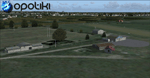
Opotiki aerodrome (ICAO: NZOP) is a small airstrip outside the township of of Opotiki, the gateway to the beautiful East coast of the North Island of New Zealand. Opotiki itself sits at the confluence of the Waioeka and Otara rivers and is surrounded by dairy farmland and Kiwifruit orchards with large areas of native bush to the south and east.
This scenery accompanies Tim Barnes'�� series of other small Bay of Plenty aerodromes (Whakatane,
Galatea, Waihi Beach) for use with VectorLandClass- It features custom modelled and textured buildings, large coverage of beautiful 0.5m aerial photography (fully auto-genned and including seasonal and night variations) and extensive use of high quality objects from the free VLC library. Installation of the library V1.1+ is required for this scenery to work properly and can be downloaded from the VectorLandClass website (www.vectorlandclass.co.nz)
This release, although not requiring it, works best with VectorLandClass topographic mesh and landclass addon covering all 268676 square kilometers of New Zealand. If you'��re not a VLC customer, you'��ll notice when the photoreal coverage runs out!
| Filename: | NZOP_Opotiki_Aerodrome_VectorLandClass_New_Zealand.zip |
| License: | Freeware, limited distribution |
| Added: | 21st February 2013, 13:52:47 |
| Downloads: | 969 |
| Author: | Tim Barnes |
| Size: | 146.68 MB |
| Category: Flight Simulator 2004 - Scenery | |
| Kimmirut CYLC on Baffin Island in Nunavut, Canada |
|
Images related to this file:
File Description:
Kimmirut is a village of some 400 folks at the southern end of the southwest-facing coast of Baffin Island, 75 miles southwest of Iqaluit. It is on the northern side of the Hudson Strait between Baffin Island and Quebec, opposite Kangiqsujuaq on the Quebec shore. The airfield is served by two flights per week, one on Monday and another on Friday, only half fueled to be able to use the 1,899' of gravel 75' wide runway. The terminal building is small and there is a garage building for airport maintenance vehicles (snow clearing). There are some nearby buildings that I have included. The village is "represented" (not "modeled") with approximately the right shape and road layout. Take enough fuel so that you can leave again, as fuel is no longer for sale here. The Cape Dyer bgls are to make a small correction, it is explained in the text. I will not be posting new sceneries in the future and this is the last one for Avsim; it completes Baffin Island.
| Filename: | Kimmirut_CYLC_on_Baffin_Island_in_Nunavut_Canada.zip |
| License: | Freeware, limited distribution |
| Added: | 25th July 2011, 17:36:57 |
| Downloads: | 534 |
| Author: | Roger Wensley |
| Size: | 2.53 MB |
| Category: Flight Simulator 2004 - Scenery | |
| Union Island TVSU in the Grenadines |
|
Images related to this file:
File Description:
Union Island is in the southern tail of the chain of islands known as St Vincent and the Grenadines, between Canouan and Carriacou. Union is another small island, 3.5 miles long and at its widest 1.5 miles wide; the resident population is around 3,000, mostly in the two towns Clifton and Ashton.
The airport is at the eastern end of the island, and has been extended into the sea on landfill. The runway is now around 2,480 feet long, aligned 08 (and with the southeast trade winds it is unlikely that you will find yourself using 26) and with a displaced threshold of 530 feet due to the hill to the west. The terminal is adjacent to a rather small apron; there is parking on the grass north of the taxiway. There are connecting flights by SVG to Barbados and the other islands and these are reflected in the AI. The airport has no lighting, and flights are obliged to land and depart in daylight hours only, outside of which the airport is closed.
| Filename: | Union_Island_TVSU_in_the_Grenadines.zip |
| License: | Freeware, limited distribution |
| Added: | 11th June 2013, 23:26:50 |
| Downloads: | 435 |
| Author: | Roger Wensley |
| Size: | 2.02 MB |
© 2001-2026 AVSIM Online
All Rights Reserved
Privacy Policy |