
Where Flight Simulation Enthusiasts Gather from Around the World!
AVSIM Library - Search Results

| Category: Flight Simulator X - Aircraft Repaints, Textures and Modifications | |
| Modification of the power table for the TIO-540-AJ1A para Cessna CT206H de CARENADO. |

|
Images related to this file:
File Description:

New update of flight dynamics settings.
Corrected the indicated speed error (KIAS) vs the true speed (KTAS) according to the data suggested in the pilot's operating manual (POH).
In some cases the position of the center of gravity unladen weight is corrected for a better weight and balance of the airplane.
Actual direct references from Pilot Operations Manual (POH) for specific details, Power,
Nose or pitch position and weight and balance settings, airplane geometry, piston or turbine engine data,
propeller and everything that refers to references, also the real references of the manufacturers of sea engines whatever the specific case.
| Filename: | Modification_of_the_power_table_for_the_TIO540AJ1A.zip |
| License: | Freeware |
| Added: | 15th April 2020, 18:47:15 |
| Downloads: | 145 |
| Author: | Rafael Ledezma |
| Size: | 432.37 KB |
| Category: Flight Simulator 2004 - Scenery | |
| Fort Nelson CYYE in British Columbia, Canada |
|
Images related to this file:
File Description:
Fort Nelson is close to the Peace River in the northeast corner of British Columbia, around 70 miles from the northern border, 90 from the eastern border, and 80 miles east of the Rockies. The wartime construction of the Alaska Highway actually started from Fort Nelson, as there was already a road from Fort St John (which is close to Dawson Creek) north to Fort Nelson. The airfield was part of this construction effort and after the wartime ferrying of planes to Russia it was used by the US Army Air Force and then by the Canadian Air Force. Fort Nelson flourished with the oil and gas exploration of the 1950's and the following years, and this continued to grow until the collapse of the oil price in 2014.
The town of Fort Nelson became the capital of the Northern Rockies Regional District when it was founded in 2009, and as a result the official name of the Fort Nelson airport is the Northern Rockies Regional Airport. The date for this scenery is around 2016, by which time the economic fortunes of the town were in decline. Five times per day flights by Central Mountain Air were starting to be reduced in number to the current (in 2022) one per day and none on Sunday; in the AI included here there are two flights per day. The main resident users of the airport are four helicopter companies, the helicopters presumably used for maintenance trips to whatever parts of the oil and gas fields that are still in use in the surrounding area.
There are two runways, the main one is aligned 03-21, 6,400 feet long and 200 feet wide, with ILS at the southern end and PAPI at the northern. The second runway (a narrower rebuild on a previously existing runway) is aligned 07-25 and 77 feet wide, and is without any lights. These are the alignments as per the original build of FS9 and not as per the approximate 2016 date of the buildings; I had a problem at a very late stage in making this scenery which prevented me from continuing with some final details.
On YouTube there is a series of posts by Angle of Attack showing the preparation and then the flight of an old Cessna 172 from Homer to Oshkosh for the installation of modern instruments. Interesting for me as they visit or fly over airfields I have made (Homer, Merrill, Tok Junction, Burwash, Silver City, Haines Junction, Watson Lake, Fort Nelson, and Grande Prairie) but in the winter so it all looks very different.
| Filename: | Fort_Nelson_CYYE_in_British_Columbia_Canada.zip |
| License: | Freeware, limited distribution |
| Added: | 23rd January 2022, 20:11:18 |
| Downloads: | 188 |
| Author: | Roger Wensley |
| Size: | 28.35 MB |
| Category: Flight Simulator X - Gauges | |
| AP - Alt - VS MultiFuel Flaps v1 |
|
Images related to this file:
File Description:
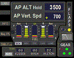
This gauge is for use in the Saitek FIP and is an extension to my recent Baron 58 (FSX default) gauge . That gauge was designed for a specific aircraft whilst this package of three gauges has the same functionality of the BB58 gauge but will work on all aircraft. Each of the three gauges displays fuel level for different tanks but are identical in all other respects. As part of your pre-flight checklist you will need to make sure the right gauge for the aircraft is being displayed.
The set of 3 gauges have been designed to complement the saitek AP / Multi panel. The gauges primarily show the selected AP Altitude and Vert Spd whilst the AP / multi panel is displaying HDG. Five indicators for "lights on" are included as well as lights for landing gear (in transition and down) . The flaps indicator shows a blue light for intermediate positions and a yellow light when at full down position. A separate flaps position indicator (numerical and needle) is included. The 5 fuel indicators in each gauge are vertical analogue 'meters'. Rudder and aileron trim is displayed and controlled by the two FIP rotary knobs. Pitch trim readout and other functions is included.
NOTE. This package includes a pitch trim image file that was inadvertently left out of my original BB58_AP_Alt_VS_and_Fuel_v1.zip folder.
| Filename: | AP__Alt__VS_MultiFuel_Flaps_v1.zip |
| License: | Freeware |
| Added: | 12th July 2014, 07:40:09 |
| Downloads: | 400 |
| Author: | Robert Budd |
| Size: | 183.72 KB |
| Category: Flight Simulator 2004 - Scenery | |
| Custer Airport, KTTF, Monroe, MI |
|
Images related to this file:
File Description:
FS2004 Scenery - Custer Airport (ICAO: KTTF, FAA LID: TTF), sometimes referred to as Monroe Custer Airport, is a city-owned public airport located in the city of Monroe in Monroe County, Michigan. The airport opened in November 1946 and was named for George Armstrong Custer, who spent much of his early life in Monroe. Custer Airport is able to accommodate a large variety of aircraft, including single engine aircraft, twin engine aircraft, and business jets such as the Cessna Citation and Learjet. The airport has personal hangars that house approximately 45 airplanes and a large hangar that houses several corporate aircraft as well as the Monroe Aviation School of Flight and Monroe Aviation Aircraft Maintenance. Created using Instant Scenery 2. AI Aircraft included. By John B. Loney, Jr.
| Filename: | Custer_Airport_KTTF_Monroe_MI.zip |
| License: | Freeware, limited distribution |
| Added: | 13th July 2010, 02:50:52 |
| Downloads: | 453 |
| Author: | John B. Loney, Jr. |
| Size: | 5.6 MB |
| Category: Flight Simulator X - Scenery | |
| Custer Airport, KTTF, Monroe, MI |
|
Images related to this file:
File Description:
FSX Scenery - Custer Airport (ICAO: KTTF, FAA LID: TTF), sometimes referred to as Monroe Custer Airport, is a city-owned public airport located in the city of Monroe in Monroe County, Michigan. The airport opened in November 1946 and was named for George Armstrong Custer, who spent much of his early life in Monroe. Custer Airport is able to accommodate a large variety of aircraft, including single engine aircraft, twin engine aircraft, and business jets such as the Cessna Citation and Learjet. The airport has personal hangars that house approximately 45 airplanes and a large hangar that houses several corporate aircraft as well as the Monroe Aviation School of Flight and Monroe Aviation Aircraft Maintenance. Created using Instant Scenery 2. AI Aircraft included. By John B. Loney, Jr.
| Filename: | Custer_Airport_KTTF_Monroe_MI.zip |
| License: | Freeware, limited distribution |
| Added: | 13th July 2010, 02:51:45 |
| Downloads: | 669 |
| Author: | John B. Loney, Jr. |
| Size: | 5.61 MB |
| Category: Flight Simulator 2004 - Scenery | |
| Fort Resolution CYFR in the Northwest Territories, Canada |
|
Images related to this file:
File Description:
Fort Resolution is on the south side of Great Slave Lake, 75 miles east of Hay River and just west of where the Slave River flows into the lake from Fort Smith. Fort Resolution, the oldest community in the Territories and once a vital link in the fur trade business, is a small town with a population of around 500. It was not included in the original FS9 or Ultimate Terrain so I have added it here.
The airfield is next to the town on the lakeshore. The runway is 4,000 feet of gravel with a displaced threshold at the southern (town) end; it is lit and there is PAPI. There are no scheduled flights to Fort Resolution, just occasional charters; the AI includes a stock FS9 Cessna and a Wasaya Airways PC12.
| Filename: | Fort_Resolution_CYFR_in_the_Northwest_Territories_.zip |
| License: | Freeware, limited distribution |
| Added: | 4th October 2013, 22:11:26 |
| Downloads: | 294 |
| Author: | Roger Wensley |
| Size: | 2.31 MB |
| Category: Flight Simulator 2004 - Panels | |
| Display My Favorite Picture |
|
File Description:
MyPix Panel addon. Have you been flying so long that you have forgotton what your wife, husband, girfriend, significant other or mother-in-law looks like? This little panel addition allows you to display your favorite picture (.bmp format) by clicking on a panel icon. This can be added to virtually any panel - setups for the default b737-400 and Cessna 172sp are included. This can be used to display any .bmp formatted picture so in addition to your favorite pin-up, a chart or runway layout could be displayed - the possibilities are limited only by your imagination. Unzip to a temporary folder (use folders option checked) and follow the install instructions. Compiled by David Marshall, Plano, Texas. Note: I am not responsible for how you fly if your mother-in-law's picture is displayed!
| Filename: | Display_My_Favorite_Picture.zip |
| License: | Freeware |
| Added: | 15th November 2004, 14:01:14 |
| Downloads: | 1,213 |
| Author: | David Marshall |
| Size: | 1.53 MB |
| Category: Flight Simulator 2004 - Aircraft Repaints, Textures and Modifications | |
| Black Version of the Flight1 172R |
|
File Description:
This is a Black repaint of the Flight1 Cessna 172R for those secret missions you might have to do at night. It does have the call letters on the side. But in a very dark red to make it difficult to see.
I use the call letters "N826SA" when asked during install process..
Please download my blank modified template on AVSIM and start doing some repaints. I am very new at this and I am still having some problems with different areas of the paint jobs. Mainly the rudder and the right side of the plane. If you look at it at a certain angle you can see the reflective lines of the original Flight1 body stripe lines. Any suggestions on making it easier to do the repaints or solutions please email me below !
| Filename: | Black_Version_of_the_Flight1_172R.zip |
| License: | Freeware |
| Added: | 6th February 2005, 19:45:31 |
| Downloads: | 232 |
| Author: | Lawrence Dorries |
| Size: | 846.9 KB |
| Category: Flight Simulator 2004 - Flight Plans | |
| World Challenge Western Brazil |
|
File Description:
In this challenge you need to pack a lunch with you. There are some long hauls in this challenge and you start at night with with your light fully on. You will have to get above 3000 feet quickly to keep for hitting the egde of the mountain.
For this challenge you will need to use the Beechcrafts King Air, Baron 58, Cessna C182S Skylane, and Mooney Bravo. These are the only aircrafts you can use for this challenge. I have included a NAV Log so you know what airfield to fly to. You are going deep into the Amazon Jungle and then from there into Paraguay where the challenge dont stop there. So get ready for some fun and Oh watch the tree top when you land.
| Filename: | World_Challenge_Western_Brazil.zip |
| License: | Freeware |
| Added: | 29th June 2007, 07:08:18 |
| Downloads: | 309 |
| Author: | Hosea Robertson |
| Size: | 2.81 KB |
| Category: Flight Simulator X - Flight Plans | |
| Flying the Island Paradise - Archipielago Las Perlas, Panama |
|
File Description:
So you are both a Pilot and a Real State Investor! Good for you. Now that you know that Panama is the fastest growing Democratic country in Latin America you will come down and check on some land. The "Pearl" Islands are just a few miles away from Panama City so you eagerly fly to MPTO and catch the shuttle to Jesus Lopez "Rent-a-Plane" FBO. Once in your rental Cessna you are on your own, you have a map and great blue skies, its the rainy season so you might get some thunderstorms, but so what!!! you are a good pilot. Oh, as you fly the over the blue waters do check the burning fishing boat off Coco´s. Don´t forget to return the plane by 4:00 PM, Wet!
| Filename: | Flying_the_Island_Paradise__Archipielago_Las_Perla.zip |
| License: | Freeware, limited distribution |
| Added: | 12th September 2008, 18:33:33 |
| Downloads: | 822 |
| Author: | Gera Godoy Canova |
| Size: | 1.5 MB |


© 2001-2026 AVSIM Online
All Rights Reserved
Privacy Policy |