
Where Flight Simulation Enthusiasts Gather from Around the World!
AVSIM Library - Search Results

| Category: Flight Simulator 2004 - Scenery | |
| Etna Volcano seasonal effects, Sicily, Italy, Photo Real |

|
Images related to this file:
File Description:
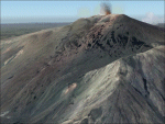
This scenery covers the summit of Etna Volcano with seasonal variation (Winter, Summer, Spring, Fall and night texture).
Use it ONLY in association of Etna photoreal scenery (see AVSIM library - etna_photoreal.zip). NOTE: place Etna_season scenery with higher priority than Etna_photoreal in scenery library (see readme text).
| Filename: | Etna_Volcano_seasonal_effects_Sicily_Italy_Photo_R.zip |
| License: | Freeware |
| Added: | 1st June 2010, 20:43:12 |
| Downloads: | 9,750 |
| Author: | Fulvio Mazzokan |
| Size: | 36.43 MB |
| Category: Flight Simulator 2004 - Scenery | |
| EZ - Henry's Lake ID & Lakeview MT |
|
File Description:
FS2004 Henry's Lake ID & Lakeview MT.
http://www.ohwy.com/id/u/u53.htm
EZ scenery requires FREE EZ scenery library.
Henry's Lake Airport serves Lake, Island Park and Fremont County and is owned by the State Of Id, Itd Div Of Aero. The turf runway extends for 4600 feet. The facility is at an elevation of 6596 feet at a distance of about 3 miles from Lake/island Park/. I remember catching large trout here when I was young with my family. Over the mountain is Lakeview airport (also included MT46).
Additional Remarks
- NO WINTER MAINTENANCE.
- RECOMMEND LAND RWY 06 TAKEOFF RWY 24 WHEN WIND CONDITIONS ALLOW.
- LIVESTOCK & BIG GAME ANIMALS HAVE ACCESS TO RY DURING FALL, WINTER & SPRING; DO NOT LEAVE ACFT UNATNDD DURING THESE SEASONS. - jimmy R martin
| Filename: | EZ__Henrys_Lake_ID__Lakeview_MT.zip |
| License: | Freeware |
| Added: | 19th June 2006, 05:43:18 |
| Downloads: | 501 |
| Author: | jimmy R martin |
| Size: | 303.95 KB |
| Category: Flight Simulator 2004 - Scenery | |
| One Hundred Mile House CAV3, British Columbia, Canada |
|
Images related to this file:
File Description:
One Hundred Mile House is eight miles south of 108 Mile Airport in BC and this version HAS THE MISSING TEXTURES! It is also 75 miles northwest of Kamloops. The runway 08/26 is 1,900 feet long and asphalt (except in the winter, when it is described as "snow"; there is also a note about limited winter maintenance) and almost in the middle of town. The apron is at the eastern (town) end of the runway and on the south side of this there is a large pond which attracts ducks and other water birds. Try to avoid the geese, they can weigh 14lb and come through the prop AND the perspex and up close have dark brown eyes; I speak from an experience 50 feet above the Rockcliffe runway.
| Filename: | One_Hundred_Mile_House_CAV3_British_Columbia_Canad.zip |
| License: | Freeware, limited distribution |
| Added: | 8th February 2010, 09:50:00 |
| Downloads: | 809 |
| Author: | Roger Wensley |
| Size: | 4.02 MB |
| Category: Flight Simulator 2004 - Scenery | |
| PAWS - Wasilla - Anchorage, Alaska - USA |
|
Images related to this file:
File Description:
Wasilla PAWS is in Alaska, some 27 miles northeast of Anchorage and 11 miles due north of Birchwood, on the northern side of the Knik Arm. It is, like Birchwood, a small version of Merrill Field for mostly GA aircraft and private hangars, with some maintenance shops. The town of Wasilla is shown in FS9 and is quite large. There are a bunch of private airfields within a ten mile radius and some of these will be posted in this series, as will some other larger airfields. The main runway is around 3,700 feet long, aligned 03-21 and asphalted and lit, as are the taxiways. Again, like Birchwood, there is also a shorter and parallel runway that is grass and which receives no winter maintenance, for winter use by planes that are on skis.
| Filename: | PAWS__Wasilla__Anchorage_Alaska__USA.zip |
| License: | Freeware, limited distribution |
| Added: | 13th October 2014, 15:04:08 |
| Downloads: | 319 |
| Author: | Roger Wensley |
| Size: | 18.73 MB |
| Category: Flight Simulator 2004 - Scenery | |
| Frozen rivers and lakes (and sea) for Alaska's winter |
|
Images related to this file:
File Description:
This "freezes" all lakes and rivers (and some sea) for winter flying and means they can be landed on with skis or wheels; it is meant for low level flying rather than high level jet flights. This edition covers all of Alaska, except for the Aleutian Islands, as the worst area to do this for is a string of islands. Terrible. Fiddly. It is reversible with an "untick" in the FS scenery library. I have spent some time making sure that the sea and the larger inlets along the southern coast do not get frozen too as they stay ice-free in winter. Along the north shore I went for the peak of the winter with sea ice all the way to the permanent polar cap; this is not totally realistic as there is usually a partially open lead along the coast, but anything else would be ...... fiddly. This is really for use with Ultimate Terrain, though it will work without it. But as UT is what gets all the lakes and rivers there and in the right place it would be a shame not to be using UT. There is a blurry transition between southern Alaska and Canada so you may need the recent Canada post too.
| Filename: | Frozen_rivers_and_lakes_and_sea_for_Alaskas_winter.zip |
| License: | Freeware, limited distribution |
| Added: | 8th September 2011, 11:53:51 |
| Downloads: | 681 |
| Author: | Roger Wensley |
| Size: | 493.23 KB |
| Category: Flight Simulator 2004 - Scenery | |
| Updates for Rockcliffe CYRO in Ottawa Canada |
|
Images related to this file:
File Description:
Flight Ontario posted their scenery for CYRO in 2008. I originally learned to fly at Rockcliffe Flying Club and came up with some additions and modifications in 2009, and now with the passage of time there are more changes. This version replaces the previous updates and is a self-contained version.
A mini tornado in 2009 destroyed the old willow tree and almost put paid to the clubhouse too (though all the buildings are still standing right now) so there is a new (temporary) clubhouse, a new hangar, the willow tree is gone, the car park is enlarged and is now asphalt, the fence line is revised and the entrance gate relocated. The previous modifications included the refueling point near the RFC buildings, revised apron shape, gravel car park, parked cars, extended perimeter fence, deck in front of the RFC clubhouse, more parked planes, the large and old willow tree, and the float dock in the river. Note in the winter picture the Ottawa River is frozen, as it is right now in reality, and you can download my "Frozen Lakes etc" post and turn your own Canadian winter into reality; I have been surprised by how few people are interested in winter flying in FS9.
| Filename: | Updates_for_Rockcliffe_CYRO_in_Ottawa_Canada.zip |
| License: | Freeware, limited distribution |
| Added: | 5th March 2010, 18:05:35 |
| Downloads: | 568 |
| Author: | Roger Wensley |
| Size: | 2.43 MB |
| Category: Flight Simulator 2004 - Scenery | |
| Meschede-Schueren Airfield |
|
File Description:
Scenery of german general aviation and glider airfield Meschede-Schueren (EDKM).
Meschede is one of the oldest glider airfields in Germany. In 1933 an airshow
was the begining of flying in Schueren. Today only the old building of the pilot´s school can be seen. Schueren is located near the lake Hennesee in west Germany.
The scenery has night effects and winter textures.
| Filename: | MeschedeSchueren_Airfield.zip |
| License: | Freeware, limited distribution |
| Added: | 27th October 2003, 00:07:51 |
| Downloads: | 2,169 |
| Author: | Thomas Gierse |
| Size: | 4.41 MB |
| Category: Flight Simulator 2004 - Scenery | |
| Parker-Carson STOLport Version 2.1.1 |
|
Images related to this file:
File Description:
Parker-Carson STOLport is privately owned, public use airfield located east of Carson City, Nevada. Scenery features custom objects, custom terrain textures, HD airport textures (.5 ft/px), traffic, day, night and winter textures, and much more. This is version 2.1.1 of the scenery and is a stand alone install, all previous versions should be removed prior to installation. Created by Dustin Mosher
| Filename: | ParkerCarson_STOLport___Version_211.zip |
| License: | Freeware, limited distribution |
| Added: | 10th December 2009, 00:25:20 |
| Downloads: | 859 |
| Author: | Dustin Mosher |
| Size: | 57.7 MB |
| Category: Flight Simulator 2004 - Scenery | |
| RealityPack 1.2: Comprehensive Enhancement Package - Part 1 |
|
File Description:
RealityPack 1.2 is a major enhancement of FS2004. New forests, meadows, cliffs, runways, taxiways, roads with traffic, rails with trains, trees, airport lighting, complete texture set for Europe and more. More than 600 high-definition, highly detailed realistic textures reengineered by hand from aerial photographs for unprecedented detail.
Subtle 3D-effects, real sunlight emulation, careful colour blending, contrast and definition and seasonal variety combined with no frame rate impact will create a new level of realism and immersion. Real macrostructures with recognisable ground detail blend into a realistic landscape. Works well for both low level and high altitude flights. Summer, fall and soft winter seasons included (hard winter forests only for Europe at the moment). For a full list of contents check out the posts in the avsim screenshot forum or the included readme file.
| Filename: | RealityPack_12_Comprehensive_Enhancement_Package__.zip |
| License: | Freeware, limited distribution |
| Added: | 29th January 2006, 01:21:32 |
| Downloads: | 101,290 |
| Author: | Sascha Rieger |
| Size: | 22.64 MB |
| Category: Flight Simulator 2004 - Scenery | |
| RealityPack 1.2: Comprehensive Enhancement Package - Part 2 |
|
File Description:
RealityPack 1.2 is a major enhancement of FS2004. New forests, meadows, cliffs, runways, taxiways, roads with traffic, rails with trains, trees, airport lighting, complete texture set for Europe and more. More than 600 high-definition, highly detailed realistic textures reengineered by hand from aerial photographs for unprecedented detail.
Subtle 3D-effects, real sunlight emulation, careful colour blending, contrast and definition and seasonal variety combined with no frame rate impact will create a new level of realism and immersion. Real macrostructures with recognisable ground detail blend into a realistic landscape. Works well for both low level and high altitude flights. Summer, fall and soft winter seasons included (hard winter forests only for Europe at the moment). For a full list of contents check out the posts in the avsim screenshot forum or the included readme file.
| Filename: | RealityPack_12_Comprehensive_Enhancement_Package__.zip |
| License: | Freeware, limited distribution |
| Added: | 29th January 2006, 01:22:35 |
| Downloads: | 85,715 |
| Author: | Sascha Rieger |
| Size: | 10.48 MB |
© 2001-2026 AVSIM Online
All Rights Reserved
Privacy Policy |