
Where Flight Simulation Enthusiasts Gather from Around the World!
AVSIM Library - Search Results

| Category: Flight Simulator 2004 - Scenery | |
| E T Joshua TVSV on Saint Vincent in the eastern Caribbean |

|
Images related to this file:
File Description:
Saint Vincent island is the northernmost of the group of islands known as St Vincent and the Grenadines, just south of St Lucia. St Vincent is around 17 miles long and 10 miles wide and by far the largest in the group, and the islands have a total population of around 120,000. E T Joshua is at the southern end of the island, adjacent to the capital Kingstown. There is a new airport under construction a few miles to the east which will have a longer runway and a larger apron, and when it is ready E T Joshua will probably be closed and redeveloped.
The terminal and the other smaller buildings are all made with photographic textures; the terminal is now quite old and has seen better days. The airport is a hub for small local airlines and also has regular LIAT flights connecting to other islands. The runway is just a shade under 4,700 feet of asphalt, so there are no direct flights from Europe. The new airport to the east is depicted as under construction; obviously I have not flown there and I have not tried to depict the terminal building which is also under construction but a mystery to me.
| Filename: | E_T_Joshua_TVSV_on_Saint_Vincent_in_the_eastern_Caribbean.zip |
| License: | Freeware, limited distribution |
| Added: | 11th June 2013, 16:29:42 |
| Downloads: | 536 |
| Author: | Roger Wensley |
| Size: | 3.13 MB |
| Category: Flight Simulator 2004 - Scenery | |
| City of Sarasota, FL V1.0 |
|
File Description:
City of Sarasota scenery is one of my largest projects. Sarasota city location is in West Florida, near Tampa and St Petersburg. Just install and start your flight from KSRQ (Sarasota/Bradenton Intl) then ENJOY ;) To make your flight realistic in Sarasota area, i recommend the Rob Diebold's outstanding add-on KSRQ airport. It's only for FS2002 but works in FS9 too ;)
| Filename: | City_of_Sarasota_FL_V10.zip |
| License: | Freeware |
| Added: | 30th March 2004, 01:58:22 |
| Downloads: | 5,477 |
| Author: | Toni Hiltunen |
| Size: | 1.57 MB |
| Category: Flight Simulator 2004 - Scenery | |
| Imperial Airship scheme - bases for airship passenger and mail service over British Empire. |
|
File Description:
FS2004 Scenery.
2008 (c) Alexander Belov , Freeware.
This scenery represents four main sites of Imperial Airship scheme - bases for airship passenger and mail service over British Empire, constructed at the end of 20-th years of XX century.
Airports included: Karachi Civil airport and Karachi Seaplane Port (former British India), Ismailia RAF station (Egypt), Cardington airship station (England), St-Hubert airfield (Canada).
| Filename: | Imperial_Airship_scheme__bases_for_airship_passenger_and_mail_service_over_British_Empire.zip |
| License: | Freeware |
| Added: | 16th June 2008, 09:39:43 |
| Downloads: | 768 |
| Author: | Alexander Belov |
| Size: | 7.04 MB |
| Category: Flight Simulator 2004 - Scenery | |
| J F Mitchell TVSB on Bequia in the Grenadines |
|
Images related to this file:
File Description:
Bequia island is one of the northernmost of the group of islands known as St Vincent and the Grenadines, just south of St Vincent. Bequia is a small curved island island, 8 miles long and in general less than a mile wide; as a result the resident population is less than 5,000.
There are two main towns, Port Elizabeth (the capital, on the bay) and Paget Farm (close to the airport).
The airport is built on reclaimed land parallel to the beach along the south coast, just west of Paget Farm; the runway is 3,700 feet long. The terminal is fairly new, or appears to be, though it may have just been well cared for. There are connecting flights by SVG to Barbados and the other islands and these are reflected in the AI.
| Filename: | J_F_Mitchell_TVSB_on_Bequia_in_the_Grenadines.zip |
| License: | Freeware, limited distribution |
| Added: | 11th June 2013, 22:56:21 |
| Downloads: | 467 |
| Author: | Roger Wensley |
| Size: | 2.83 MB |
| Category: Flight Simulator 2004 - Scenery | |
| LHA-1 Tarawa * Florida Fleet * by LBMartin |
|
File Description:
This scenery adds the LHA-1 Tarawa group near the Florida coast. I just designed a new macro using EOD. The group is about 30 nm SE from St. Augustine, FL. There you have the main ship as well two antisubmarine frigates and one tanker (both with landable helipads). If you need to refuel, just go to the tanker, land there and you will be refueled.
| Filename: | LHA1_Tarawa__Florida_Fleet__by_LBMartin.zip |
| License: | Freeware, limited distribution |
| Added: | 15th November 2005, 23:27:33 |
| Downloads: | 1,391 |
| Author: | Martin Lopez a.k.a. LBMartin |
| Size: | 2.45 MB |
| Category: Flight Simulator 2004 - Scenery | |
| Grindstone Island grass strip New York and the St. Lawrence River |
|
File Description:
Grindstone Island is in the St. Lawrence River and an area known as 1,000 Islands, close to Lake Ontario. I am posting it here along with Maxson as they are close, although at the Grindstone Island strip there is absolutely nothing except a grass runway. I have no idea who uses it or how often, but it is there. And now it is here too.
| Filename: | Grindstone_Island_grass_strip_New_York__and_the_St.zip |
| License: | Freeware |
| Added: | 1st August 2007, 18:35:52 |
| Downloads: | 486 |
| Author: | Roger Wensley |
| Size: | 172.73 KB |
| Category: Flight Simulator 2004 - Scenery | |
| CFB North Star, v7.1 |
|
Images related to this file:
File Description:
CFB North Star (version 7.1) fictional Canadian arctic military/commercial base for FS2004. Features triple runway configuration of the earlier versions, along with custom buildings and effects. Three alternate scenery configurations are provided for, including opened hangars, with unique library objects that may be used in other freeware scenery projects. Also includes flightplans and AI ship traffic (the icebreaker CCGS Louis St-Laurent). FREEWARE by Brian Sturton.
| Filename: | CFB_North_Star_v71.zip |
| License: | Freeware, limited distribution |
| Added: | 10th October 2011, 13:45:08 |
| Downloads: | 484 |
| Author: | Brian Sturton |
| Size: | 22.79 MB |
| Category: Flight Simulator 2004 - Scenery | |
| Vance W. Amory International Airport, St Kitss and Nevis (TKPN), Update to version 1.1 |
|
Images related to this file:
File Description:
This zip-file contains a update to version 1.1 of my scenery for the Vance W. Amory International Airport in St. Kitts and Nevis. Original version 1.0 is required. Update contains:
- Removed flatten-area which conflicted with default FS9 mesh terrain settings.
- Corrected AFCAD file
- Fixed some small bugs
- New displaced threshold markings
- Modified windsocks
- Added working marshalers on parking spot 1 & 2 (front of the terminal)
| Filename: | Vance_W_Amory_International_Airport_St_Kitss_and_N.zip |
| License: | Freeware, limited distribution |
| Added: | 2nd April 2010, 01:24:50 |
| Downloads: | 1,828 |
| Author: | Marcel Ritzema |
| Size: | 57.77 KB |
| Category: Flight Simulator 2004 - Scenery | |
| Colorado Hops by LBMartin |
|
File Description:
For helicopter lovers. In this scenery you will find several spots around Denver, CO. Updated Jeffco airport ("Rotors of the Rockies" hangars, new control tower, new main building, Fire station, McCair building, R22 School...), helipads in some airports in the near area, S&R Base, "The Fort" Restaurant, "Manor House" Restaurant, Mountain Resort, Swedish Medical Center, North Suburban Medical Center, St Anthony North Hospital...
| Filename: | Colorado_Hops_by_LBMartin.zip |
| License: | Freeware, limited distribution |
| Added: | 25th November 2005, 23:05:57 |
| Downloads: | 1,394 |
| Author: | Martin Lopez a.k.a. LBMartin |
| Size: | 10.46 MB |
| Category: Flight Simulator 2004 - Scenery | |
| St. George (KSGU) / Mesquite (67L), Utah/Nevada, Photo-Scenery (FS9 & FSX) |
|
Images related to this file:
File Description:
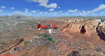
Covers the area between St. George, Utah and Mesquite, Nevada. To the north of St. George
the Pine Valley Mountains with their foothills of scenic red sandstone loom over the city.
St. George Municipal Airport (KSGU) is mostly used for general aviation but is also served by SkyWest Airlines
on behalf of Delta Connection. Because of it's location on a mesa this airport can't be expanded and so a new
airport is currently being built southeast of the city at the site of an abandoned airfield. The opening
is expected in 2011. To the south of the city make sure, you don't miss the Virgin River Gorge where the
Virgin River winds thru a long winding canyon in the transition zone between the red rocks of southern Utahs
Colorado Plateau and Nevadas Mojave Desert. Shortly afterwards you reach Mesquite which is situated just
west of the Arizona stateline. Like nearly all Nevada cities near the stateline Mesquite is home to several
Casinos. Mesquite Airport (67L) lies just north of the city.
High resolution versions of this scenery for FS9 and FSX (much sharper, but larger and multiple downloads)
are available at www.blueskyscenery.com/CNY_South3West6.html . The screenies are taken from the high-res versions,
so expect this version to be slightly more blurry. Thanks to Joop Mak for providing custom AFCADs that
correct airport layouts so that they align with the photo-textures! They are available at www.blueskyscenery.com/AFCADs.html .
YourDonation@Work: Dedicated to Werner, Ralf-Peter and Nels.
| Filename: | St_George_KSGU__Mesquite_67L_UtahNevada_PhotoScene.zip |
| License: | Freeware, limited distribution |
| Added: | 24th March 2010, 19:41:43 |
| Downloads: | 1,649 |
| Author: | Gottfried Razek - blueskyscenery.com |
| Size: | 95.58 MB |
© 2001-2026 AVSIM Online
All Rights Reserved
Privacy Policy |