
Where Flight Simulation Enthusiasts Gather from Around the World!
AVSIM Library - Search Results

| Category: Flight Simulator 2004 - Scenery | |
| Dutch Harbour PADU and St Paul PASN - UPDATES |

|
Images related to this file:
File Description:
This has revised runway circulation for both Dutch Harbour (dutchplus.zip) and St Paul (st_paul.zip) to better reflect reality in helicopter and aircraft operation. It is not realistic for a helicopter to land, continue in a straight line along 6,000' of runway, turn at the far end, then taxi back along the same 6,000' to the aprons. Similarly, a Cessna does not need the same runway length as a 747.
This fix incorporates intermediate turnaround points to allow helicopters and small aircraft to turn around soon after slowing to taxi speed and to taxi back to the aprons at the end of the runway, instead of trudging along the whole length of the runway twice. There are some things that cannot be improved; a plane or helicopter will always taxi all the way from the aprons to the far end of the runway before turning and taking off, and a helicopter or light plane will not "land long" to minimise the taxi length.
The pictures show different turning points. There are also revised AI bgl's to provide better time separation between flights.
| Filename: | Dutch_Harbour_PADU_and_St_Paul_PASN__UPDATES.zip |
| License: | Freeware, limited distribution |
| Added: | 16th August 2012, 19:37:32 |
| Downloads: | 941 |
| Author: | Roger Wensley |
| Size: | 2.53 MB |
| Category: Flight Simulator 2004 - Scenery | |
| Fort St James CYJM in British Columbia Canada |
|
Images related to this file:
File Description:
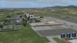
Fort St James is a small town of around 1,600 folks at the southeastern end of Stuart Lake, at the head of the Stuart River, and around 360 miles north of Vancouver and 220 miles inland from the coast. It was a long-established trading post for furs, with a permanent presence there from 1806 onwards. The airfield is 3 miles south of the town and is called "Fort St James (Perison)" in the Nav Canada listings. I presume that this is part of their trend towards calling airfields by their location rather than by their name. Makes sense as it is difficult to find information by searching for an airfield that is listed under a name you don't know. The field has an asphalt runway of 4,000 feet aligned 10-28 and at 2,364 feet ASL. There is no lighting. The main user of the airfield is Interior Helicopters Ltd. who are based there as operators, and at Williams Lake as helicopter dealers. For the AI helicopters, there is a screenshot (01) of the AS350 helicopter installation folder when it has been transformed into an AI helicopter. The process is to download and install the Ecuriel AS 350, along with the additional textures, as normal; this is straightforward. Then you download the software shown in screenshot 02 and add it as instructed and as shown in 01 so that the helicopter now operates as AI, with a different air file and a modified config file. I should have included this with the Pemberton post. I have posted this as Fort St James CYJM, but I suggest that you just add it to your previously created "BC airfields" and avoid the inevitable doubling up of common textures etc. Up to you. If you find a defect, email me.
| Filename: | Fort_St_James_CYJM_in_British_Columbia_Canada.zip |
| License: | Freeware, limited distribution |
| Added: | 23rd November 2020, 20:14:04 |
| Downloads: | 150 |
| Author: | Roger Wensley |
| Size: | 2.62 MB |
| Category: Flight Simulator 2004 - Scenery | |
| City of St. Augustine, Florida v1.1 quick FIX |
|
File Description:
This includes "fixed" texture files. Download and extract these texture files to FS9/Addon Scenery/CityOfStAugustineFl/texture folder and overwrite.
| Filename: | City_of_St_Augustine_Florida_v11_quick_FIX.zip |
| License: | Freeware |
| Added: | 6th March 2006, 21:37:56 |
| Downloads: | 1,630 |
| Author: | Toni Hiltunen |
| Size: | 35.99 KB |
| Category: Flight Simulator 2004 - Scenery | |
| FS9 Fort St John CYXJ in BC Canada |
|
File Description:
Fort St John is close to the border between British Columbia and Alberta, around 40 miles north-northwest of Dawson Creek. The airport was originally a Royal Canadian Air Force base, associated with the wartime construction of the Alaska Highway. The airfield was part of this construction effort and the wartime ferrying of planes to Russia. It is currently named "North Peace Regional Airport", or "North Peace Airport"; apparently there has been no final decision?
The date for this scenery is around 2006. I was given an old video tape cassette which was filmed on an uncertain date, but which had to be before the terminal building was renovated in 2007 and totally changed in appearance. The only way to view the video was to play it in the camera and watch it on a small screen. After I had completed everything except the buildings I started to view the video to establish the building appearances and within an hour or so the camera died. It was so old there was no way to repair it, so I then made some new buildings from memory of the video and what was available online. I also used some that I had already made for other scenery but which were similar. I may replace the terminal building that is in this version with a build of the new one, as I know this one is not a very accurate reproduction. The replacement, if I do it, will be towards the end of this year.
The AI included here is for GA, Air Canada Jazz, and two helicopter companies that were (and still are?) based there. One is at the western end of the apron and the other is at the eastern end but separated from the apron. To gain access to the taxiways and runways (so that all airport users follow the same procedures, for safety reasons) the eastern end helicopters just taxi across the grass. The helicopters are used for maintenance trips to the oil and gas fields in the surrounding area. My screenshots show Westjet at the terminal; this is because I have later Canadian AI installed, while the AI included here is only for the time around 2000 to 2010, when Westjet were not flying to Fort St John.
The airport is square in plan, with the apron running along the northern side and two runways forming diagonals. The two runways are 11-29 (6,882 feet long and 200 feet wide, with ILS at the 29 end and PAPI at the other) and 02-20 (6,684 feet long and 200 feet wide, and with PAPI at each end). The eastern side taxiway that runs north-south is not used. The western side taxiway is in use but only as a race track for cars.
Please email me if you find faults, such as a plane without textures.
| Filename: | FS9_Fort_St_John_CYXJ_in_BC_Canada.zip |
| License: | Freeware, limited distribution |
| Added: | 10th October 2022, 14:03:38 |
| Downloads: | 209 |
| Author: | Roger Wensley |
| Size: | 37.49 MB |
| Category: Flight Simulator 2004 - Scenery | |
| Longue-Pointe de Mingan CYLP, Quebec, Canada |
|
Images related to this file:
File Description:
This scenery represents real the airport of Longue-Pointe of Mingan (CYLP). I carried out this scenery with FSDS. Longue-Pointe of Mingan is localised on northern bank of the St-Laurent river in Quebec, Canada. This scenery is built for both FS-2004 and FS-X.
| Filename: | LonguePointe_de_Mingan_CYLP_Quebec_Canada.zip |
| License: | Freeware |
| Added: | 30th December 2009, 21:28:47 |
| Downloads: | 898 |
| Author: | Regis Dassylva |
| Size: | 9.69 MB |
| Category: Flight Simulator 2004 - Scenery | |
| Modification of Province of Quebec Landclass |
|
File Description:
FOR FS2002 AND 2004. This modification adds or makes more visible many villages,
for those that fly VFR, around Montreal/St-Hubert CYHU. *DO* READ INFOS.TXT
Cette modif ajoute ou rend plus visibles plusieurs villages, pour ceux qui volent
VFR, dans les environs de Montreal CYUL, ou CYHU. *LIRE* INFOS.TXT
| Filename: | Modification_of_Province_of_Quebec_Landclass.zip |
| License: | Freeware |
| Added: | 25th June 2010, 01:38:12 |
| Downloads: | 1,730 |
| Author: | Jean Morissette |
| Size: | 32 KB |
| Category: Flight Simulator 2004 - Scenery | |
| TISX - Henry E. Rohlsen Intl. - St. Croix Virgin Islands |
|
Images related to this file:
File Description:
"Henry E-Rohlsen Intl ( TISX ) " is the Scenery of the International Airport of Saint-Croix Island,located in The U.S. Virgins Islands south of Puerto Rico not far from Saint-Thomas Island.
| Filename: | TISX__Henry_E_Rohlsen_Intl__St_Croix_Virgin_Island.zip |
| License: | Freeware |
| Added: | 15th November 2012, 17:30:34 |
| Downloads: | 1,194 |
| Author: | Delblond Christian |
| Size: | 5.64 MB |
| Category: Flight Simulator 2004 - Scenery | |
| Fourth of July Fireworks |
|
File Description:
This scenery will add Fourth of July Fireworks to the following cities:
Columbus, Boston, Philadelphia, New York, Washington DC, Atlanta, Orlando, Tampa, Miami, Key West, Chicago, St Louis, Seattle, Portland, San Francisco, Oakland, Los Angeles, San Diego, Pittsburgh, Buffalo, Cleveland, Detroit, Phoenix, Albuquerque, Dallas, Houston, Kansas City, Milwaukee, Denver, Salt Lake City, and Nashville.
| Filename: | Fourth_of_July_Fireworks.zip |
| License: | Freeware |
| Added: | 23rd January 2006, 04:32:32 |
| Downloads: | 2,835 |
| Author: | Gregg Wolfram |
| Size: | 51.35 KB |
| Category: Flight Simulator 2004 - Scenery | |
| CTH3 Canada, Quebec, Les Grandes-Bergeronnes |
|
Images related to this file:
File Description:
This is the scenery Les Grandes Bergeronnes (CTH3), which represents the reality. Les Grandes Bergeronnes is a small village located on Northern bank of the St-Laurent river of Quebec at Canada. This scenery is designed with FSDS and it accepts Mesh of Gilles Gauthier. This scenery functions for both FS-2004 and FS-X.
| Filename: | CTH3_Canada_Quebec_Les_GrandesBergeronnes.zip |
| License: | Freeware |
| Added: | 2nd January 2010, 19:29:43 |
| Downloads: | 374 |
| Author: | Regis Dassylva |
| Size: | 2.32 MB |
| Category: Flight Simulator 2004 - Scenery | |
| VFR of Lario, Area B3 - Como lake, Italy |
|
Images related to this file:
File Description:

This 13th scenery covers approximately an area of 7.5x6 kmt, from Barni (NW) to the southern Grigna mountain (NE), from Canzo (SW) to Barro mountain (SE); some of specific buildings are included, as the Moto Guzzi rowing club (Mandello), the monument to Antonio Stoppani, the St. Nicolao church and bell tower, the Social theater with Giuseppe Garibaldi's monument, the war Memorial, the Rowing club building and the Kennedy bridge (Lecco); are included two NLC piers (Abbadia Lariana and Lecco) and the motorboat Ninfea of the NLC navigation; from Mandello to St. Martino mountain several sections of the freeway SS36 are included, with overpasses and tunnels. Some other minor boats and docks are placed alongside the lake coast.
Check video available here: http://youtu.be/EPPto_dCkSE
| Filename: | VFR_of_Lario_Area_B3__Como_lake_Italy.zip |
| License: | Freeware |
| Added: | 30th May 2013, 23:34:58 |
| Downloads: | 806 |
| Author: | Aldo Della Vedova, Daniele Lanfranchi, Gian Mario Verga |
| Size: | 24.01 MB |
© 2001-2026 AVSIM Online
All Rights Reserved
Privacy Policy |