
Where Flight Simulation Enthusiasts Gather from Around the World!
AVSIM Library - Search Results

| Category: Flight Simulator 2004 - Scenery | |
| Colorado Springs South (KCOS), Colorado, Photo-Scenery |

|
Images related to this file:
File Description:
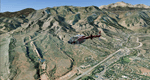
Colorado Springs South (KCOS), Colorado, Photo-Scenery (FS9 & FSX)
This region covers the area of Colorado Springs. Just west of the city you can fly around Pikes Peak. At 14.115ft it is the easternmost of Colorado's 54 fourteeners. Northwest of the city lies the Garden Of Gods with its many vertical rock formations. They are made of sedimentary beds red and white sandstones, conclomerates and limestone that were deposited horizontally but have been tilted vertically and faulted by the immense mountain building forces caused by the uplift of the Pikes Peak massiv. Deep within Chayenne Mountain is the North American Aerospace Defense Command's (NORAD) main technical facility which collects and evaluates data from a worldwide system of satellites, radars and other sensors.
High resolution versions of this scenery for FS9 and FSX (much sharper, but larger and multiple downloads) are available at www.blueskyscenery.com/GNB_South3East.html . The screenies are taken from the high-res versions, so expect this version to be slightly more blurry. YourDonation@Work: Dedicated to Veit and Hector.
| Filename: | Colorado_Springs_South_KCOS_Colorado_PhotoScenery.zip |
| License: | Freeware, limited distribution |
| Added: | 5th February 2010, 16:30:42 |
| Downloads: | 1,979 |
| Author: | Gottfried Razek, blueskyscenery.com |
| Size: | 95.63 MB |
| Category: Flight Simulator 2004 - Scenery | |
| Union Island TVSU in the Grenadines |
|
Images related to this file:
File Description:
Union Island is in the southern tail of the chain of islands known as St Vincent and the Grenadines, between Canouan and Carriacou. Union is another small island, 3.5 miles long and at its widest 1.5 miles wide; the resident population is around 3,000, mostly in the two towns Clifton and Ashton.
The airport is at the eastern end of the island, and has been extended into the sea on landfill. The runway is now around 2,480 feet long, aligned 08 (and with the southeast trade winds it is unlikely that you will find yourself using 26) and with a displaced threshold of 530 feet due to the hill to the west. The terminal is adjacent to a rather small apron; there is parking on the grass north of the taxiway. There are connecting flights by SVG to Barbados and the other islands and these are reflected in the AI. The airport has no lighting, and flights are obliged to land and depart in daylight hours only, outside of which the airport is closed.
| Filename: | Union_Island_TVSU_in_the_Grenadines.zip |
| License: | Freeware, limited distribution |
| Added: | 11th June 2013, 23:26:50 |
| Downloads: | 434 |
| Author: | Roger Wensley |
| Size: | 2.02 MB |
| Category: Flight Simulator 2004 - Scenery | |
| Kremmling, Mc Elroy (20V), Colorado, Photo-Scenery |
|
Images related to this file:
File Description:

Kremmling, Mc Elroy (20V), Colorado, Photo-Scenery (FS9 & FSX)
Ever wanted to know how the scenery looks like around Kremmling VOR? Now you got the chance! This region covers the area around Kremmling and the northern part of the Gore Range. At Kremmling the Colorado River meets both the Blue River and the Muddy Creek. West of Kremmling you can see Gore Canyon. This rugged and steep canyon is almost 1000ft deep and was carved by the Colorado River on its way thru the Gore Range.
To explore the scenery depart from Mc Elroy Airfield (20V) in Kremmling and head north. High resolution versions of this scenery for FS9 and FSX (much sharper, but larger and multiple downloads) are available at www.blueskyscenery.com/GNB_West.html . The screenies are taken from the high-res versions, so expect this version to be slightly more blurry. Thanks to Joop Mak for providing custom AFCADs that correct airport layouts so that they align with the photo-textures! They are available at www.blueskyscenery.com/AFCADs.html . YourDonation@Work: Dedicated to Michael.
| Filename: | Kremmling_Mc_Elroy_20V_Colorado_PhotoScenery.zip |
| License: | Freeware, limited distribution |
| Added: | 21st April 2010, 17:39:09 |
| Downloads: | 1,138 |
| Author: | Gottfried Razek, blueskyscenery.com |
| Size: | 91.2 MB |
| Category: Flight Simulator 2004 - Scenery | |
| Fassberg AB (ETHS) - Berlin Airlift Revival including AI-Package |
|
Images related to this file:
File Description:
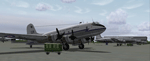
This airfield, located in Lower Saxony (North-Germany), supported the "Berlin Airlift" 06/24/1948 thru 09/30/1949, is dedicated to all the flight crews who served the "Berliner Luftbruecke".
The famous Douglas C-47 (Dakota) and the Douglas C-54 (Skymaster, was called the Candy Bomber during those days) flew day after day coal and food to Berlin to help the people survive the blockade.
The included AI-Package contains:
-Douglas C-47 Dakota and C-54 Skymaster,
-Handley Page HP-67 Hastings,
-Heinkel HE-111,
-Focke-Wulf 190,
-FW-200A Condor,
-Messerschmitt ME-109 and ME-262.
A bunch of C-47, C-54 and HP-67 hurry per IFR-Flightplan to Berlin-Tempelhof (EDDI) at a 4 hours time interval. A couple of FW-190, ME-109, ME-262, a HE-111 and a FW-200 perform touch and goes at the local field. This scenery was made with EZ. No FSE or other payware is required. Gentlemen, let's start the engines!
| Filename: | Fassberg_AB_ETHS__Berlin_Airlift_Revival_including.zip |
| License: | Freeware, limited distribution |
| Added: | 11th February 2006, 15:41:52 |
| Downloads: | 3,313 |
| Author: | Klaus Jone |
| Size: | 27.36 MB |
| Category: Flight Simulator 2004 - Scenery | |
| Baker Lake CYBK in Nunavut, Canada |
|
Images related to this file:
File Description:
Baker Lake is the only Nunavut community that is not next to the sea. It is, as you might have guessed, on the shore of Baker Lake and 160 miles west and a bit north of Rankin Inlet on the shore of Hudson Bay (a recent post by Sid and Pete). The Hudson Bay Company opened a trading post there in 1916 and the town slowly developed, though as recently as 1946 the population was still only 32. These days the airfield is the support field for several nearby mines and there are now nearly 1,800 folks in Baker Lake using the stores, schools, churches, hospital, etc. The runway is almost 4,200' of 100' wide gravel and lighted; the alignment is 162T and 342T as this is in northern domestic airspace and bearings are given as 'true" and not "magnetic". Both JETA and 100LL fuel is available. The town is to the northeast of the airfield and is made up of a landclass without autogeneration, as this would mean a bunch of trees that would be, to say the least, unrealistic.
| Filename: | Baker_Lake_CYBK_in_Nunavut_Canada.zip |
| License: | Freeware, limited distribution |
| Added: | 23rd November 2011, 09:21:56 |
| Downloads: | 513 |
| Author: | Roger Wensley |
| Size: | 2.45 MB |
| Category: Flight Simulator 2004 - Scenery | |
| Ontario Small Fields in Canada: #7 Lucan CPS4 |
|
Images related to this file:
File Description:
This is the seventh in a series of small airfields in southern Ontario Canada, Lucan CPS4; plus revised AI and parking for #6 Nixon CNX8 to include a crop spray plane (the Grumman 164) which I have just identified from a photograph; plus a note re an addition required to the different crop spray aircraft (the AT802) config file so that it parks correctly at St Thomas CYQS.
Lucan is 15 miles north of London Ontario, and 20 miles southeast of Lake Huron. The airfield is the base for a small crop spraying business and has a grass runway of 3,100 feet aligned 09/27, and with lighting. The overhead cables that previously imposed a 550 feet threshold displacement on the runway 09 approach (up to and including 2010) have now been buried. The lighting is owner-controlled and cannot be turned on from the air. Fuel and oil is available. The crop spray plane is a Grumman G164A Ag-Cat, which was manufactured in the 1970's and remains in use with a lot of owner-operators.
| Filename: | Ontario_Small_Fields_in_Canada_7_Lucan_CPS4.zip |
| License: | Freeware, limited distribution |
| Added: | 27th October 2015, 15:16:58 |
| Downloads: | 167 |
| Author: | Roger Wensley |
| Size: | 4.59 MB |
| Category: Flight Simulator 2004 - Scenery | |
| The Greater Toronto Area Part 1 |
|
File Description:
Part 1 of Flight Ontario's scenery for the Greater Toronto Area and Southern Ontario.
Over a year in the making, this scenery for Fs 2002 and Fs 2004 is bounded by Detroit in the west, Kingston in the east, Huntsville in the north and Buffalo in the south and features:
* all-season scenery
* custom water textures
* completely modelled Toronto Airports...CYTZ (Toronto Island) and CYZD
(Downsview-home to Bombardier Aerospace and the Canadair Regional Jet
and Dash-8, and the Toronto Aerospace Museum)
* custom autogen for the GTA
* Custom landclass for southern Ontario
* custom shorelines (western Lake Ontario, Kingston area, Lake
Couchiching...Severn River...Sparrow Lake area, and the Muskoka Lake
area)
* prominent features around Hamilton include the Burlington Skyway and
Lift Bridge and steel mills
* the Welland Canal is featured with lift bridges, bascule bridge and
fixed link bridge from Pt Weller to Pt Colborne
* the Niagara area includes the Minolta Tower, and 3 hydro generating
plants with reservoirs
* compatibility with SimFlyers CYYZ
This scenery is downloadable in two parts and both parts are essential
| Filename: | The_Greater_Toronto_Area__Part_1.zip |
| License: | Freeware |
| Added: | 9th April 2004, 12:40:02 |
| Downloads: | 37,176 |
| Author: | Flight Ontario |
| Size: | 62.09 MB |
| Category: Flight Simulator 2004 - Scenery | |
| HSSS Khartoum, Sudan |
|
File Description:
Googly scenery for HSSS Khartoum, Sudan. For Sudan's main international airport,
the Flight Simulator depiction is somewhat simplified, depicting just a few
buildings which are badly located. These scenery files attempt to reproduce
the real atmosphere of the airport - from the huge clutter of small hangars
and workshops and large quantities of inactive planes through to the aircraft
dump at the north end of the airport.
The scenery does not purport to be ultra-accurate. Based on high-detail satellite
imagery from Google Earth, the layout is proportionally correct but the added
airport features, such as buildings, are built from default Microsoft objects
and third-party object libraries so will not look like the real thing.
You are not obliged to download and install any additional scenery libraries,
but to enjoy this scenery in its entirety, you may wish to. It will work fine,
with or without. These files complement the Sudan Airways AI Fleet Pack by Billy Rutherford &
John Hinson, updating the scenery files contained therein, but the two are not
inter-dependent.
| Filename: | HSSS_Khartoum_Sudan.zip |
| License: | Freeware |
| Added: | 9th March 2007, 17:29:13 |
| Downloads: | 4,416 |
| Author: | John Hinson |
| Size: | 38.74 KB |
| Category: Flight Simulator 2004 - Scenery | |
| Bornholm Island 2011 DEMO |
|
Images related to this file:
File Description:

BORNHOLM ISLAND 2011 DEMO features an extremely detailed scenery of Bornholm Island and EKRN Ronne airport in Denmark, fully compatible with FS2004.
It's a fully functional DEMO version of the commercial payware product. It features same airport layout as in the full version but with limited 3D objects and low resolution textures. Using this free demo ensures no problems with online (VATSIM, IVAO, multiplayer etc.) flying in case some users use the payware scenery and some don't.
Bornholm is an island located in the Baltic Sea 37 km south of Sweden and the north of Poland. Bornholm Airport (RNN / EKRN) is a Danish airport located 2.7 nautical miles (5 km) southeast of Ronne.
It's equipped with an automatic installer, which means that the scenery will be automatically added to the Flight Simulator Scenery Library.
Please uninstall all previous versions of this airport you may have installed before. Please make also sure that no duplicated AFCAD files are installed.
Enjoy your virtual flying with Drzewiecki Design!
| Filename: | Bornholm_Island_2011_DEMO.zip |
| License: | Commercial demo |
| Added: | 5th September 2015, 01:09:19 |
| Downloads: | 3,605 |
| Author: | Drzewiecki Design |
| Size: | 12.75 MB |
| Category: Flight Simulator 2004 - Scenery | |
| Homer PaHO in Alaska US |
|
Images related to this file:
File Description:
Homer is a mainly GA airfield with rows of open air parking, but it also has scheduled flights, a terminal building, a long (for GA) runway of just under 6,700 feet that is 150 feet wide and aligned 03-21 with VASI on both ends and ILS on 03. So I think we can refer to it as an airport. Plus, at the time of this scenery (around 2010) there were three newly completed hangars on the north apron that I was told were for three companies, Bald Mountain Air service, Maritime Helicopters, and Pathfinder Aviation. I do not know which was for whom, but all three companies are in the helicopter and/or plane charter business. The south apron has a number of hangars and other buildings along it's length, starting at the western end with Smokey Bay Air that has an old control tower on the roof, then the Fire Station, and then Homer Air. I am not aware of who owns what after those first three, except that at the far eastern end there are several garages etc for the airport maintenance equipment. Next to the airport at that end there are a number of boat maintenance companies with boats pulled out of the water; this could not be well replicated due to the airport elevation above the sea level and a misplaced road. The nearby Beluga Lake 5BL float base is also included here, with some AI. The lake height above sea level has been adjusted to cope with too many cliffs intruding into the water; this is an annoying FS9 habit. The Homer scenery is as close to the actual airport as I could make it, while coping with inaccurate coast lines and roads, and grassed areas that could not all be modified for reasons that I will not bore you with. The Spit is a major scenery feature next to the airport, and I have added to this to provide some boats, docks, and nearby buildings etc. Small planes use the adjacent gravel taxi path instead of the runway when back-tracking to take off on runway 21. They only go as far as the path takes them and then u-turn onto the runway and take off. By the way, this airport's AI will function at its best if the prevailing wind makes 03 the runway in use. And I will eventually stop writing 03 and just call it 3, as the US, alone in the world, does not put a zero in front of 01, 02, 03, 04 etc. Just one other thing to note is that all access to the runway is from taxiways A and B; there was (in 2010) no access to the extreme western end of the runway as the taxiway there is marked as out of service pending a needed resurfacing.
If you find an error email me please, and note that my email address has been changed to rogwens at Gmail dot com.
| Filename: | Homer_PaHO_in_Alaska_US.zip |
| License: | Freeware, limited distribution |
| Added: | 28th July 2021, 03:31:04 |
| Downloads: | 125 |
| Author: | Roger Wensley |
| Size: | 11.86 MB |
© 2001-2026 AVSIM Online
All Rights Reserved
Privacy Policy |