
Where Flight Simulation Enthusiasts Gather from Around the World!
AVSIM Library - Search Results

| Category: Flight Simulator 2004 - Scenery | |
| VFR of Lario, Area E2 - Como Lake, Italy (Update) |

|
Images related to this file:
File Description:
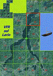
This 8th scenery covers approximately an area of 7.5x6 km, from S.Gregorio/Dongo (NW) to Colico (NE), and S.Siro (SW) to Tremenico/Aveno (SE) and includes six NLC piers: Dervio, Piona, Colico, Dongo, Musso, Pianello del Lario, in addition to the disused Cremia's one; a lot of dedicated buildings are included, as S.Tommaso of Canterbury church and fortification (Corenno), Cistercian abbey (Piona), pier and dock (Colico), S.Stefano church, factory buildings and airpollution control machinery (Dongo), Rezzonico's castle (S.Siro).
This VFR on Lario scenery includes several Dervio's details, and fully revises the previous Dervio scenery; Are included: Boldona's park office and stand, railway station, NLC shiphard, Pontile piers with Concordia steamer, dock bay with small floating pier and compass of the lake, S. Peter and Paul church and houses front of lake, hydro power station, Municipality and some other buildings, Castello's tower, windsurf school, windsurfers and kitesurfers on the lake, cross and Madonna on top of Legnoncino mountain. There are also included two viaducts between the tunnels of the freeway 36, with moted traffic. Catamarans Citta di Como and Tivano at Colico/Dongo piers together with other minor boats and docks alongside the lake coast; a moted regata with catamarans is placed in the lake between Pianello and Dervio.
This scenery SUPERSEDES AND CANCELS the previous "dervio_v2a" one, removed from the library. This is the eighth scenery of the "VFR of Lario" project, made with photorealistic terrain (multiseason & night) and with some 3D GMax realistic objects.
| Filename: | VFR_of_Lario_Area_E2__Como_Lake_Italy_Update.zip |
| License: | Freeware |
| Added: | 25th November 2012, 20:54:39 |
| Downloads: | 1,664 |
| Author: | Aldo Della Vedova, Daniele Lanfranchi, Gian Mario Verga |
| Size: | 39.39 MB |
| Category: Flight Simulator 2004 - Scenery | |
| PAIW Wales, Alaska, USA |
|
Images related to this file:
File Description:
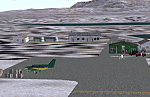
Googly scenery for Wales - a small domestic airport on the western coast of Alaska that is poorly provided for in Flight Simulator 2004. These scenery files add taxiways, aprons, buildings and other airport features, so that you and your "AI" traffic can land, taxi, park and take off in a realistic manner.
Wales is a small village with a population of just over 150 people, so the facilities at this 4000 foot gravel airstrip are fairly limited. The airport is allocated the ICAO code PAIW, although Microsoft has ignored this in Flight Simulator and uses the IATA ticket code IWK. Wales is served by light aircraft from airlines such as Bering Air, Cape Smythe Air, Frontier Flying Service, and Hageland Aviation Services. You might find it a convenient stopping-off point for a quick trip across to Russia - this is about as close as you can get and a nip across the Bering Strait will find you there in no time.
The scenery does not purport to be ultra-accurate. Based on high-detail satellite imagery from Google Earth, the layout is proportionally correct but the added airport features, such as buildings, are built from default Microsoft objects and add-on libraries so will not look like the real thing.
You are not obliged to download and install any additional scenery libraries, but to enjoy this scenery in its entirety, you may wish to. It will work fine, with or without.
[File re-uploaded at request of AVSIM]
| Filename: | PAIW_Wales_Alaska_USA.zip |
| License: | Freeware |
| Added: | 26th June 2010, 13:51:45 |
| Downloads: | 1,266 |
| Author: | John Hinson |
| Size: | 76.81 KB |
| Category: Flight Simulator 2004 - Scenery | |
| Deering PADE in Alaska |
|
Images related to this file:
File Description:
Deering is a coastal village around 55 miles southwest of Kotzebue, living from fishing and the land and with a population of around 130. The airfield is inland from the coast and has two gravel runways, 11-29 of just under 3,000 feet and 2-20 of 3,700 feet; the US is the only country that names runways with single numerals, hence 2-20 that in Canada would be 02-20. And Canada, which is a metric country and gives speed limits on roads in kilometres per hour, flies in feet and not metres for runway lengths and flight levels. The two runways could have something to do with there being a National Guard Armoury in the village, and perhaps personnel being flown in for exercises in the local countryside. Apart from the airfield itself, and it's buildings, this scenery modifies the local (mostly treeless) land class, reduces the village size to reality, and creates a new airfield background. Bering Air flies into Deering from Kotzebue and is included in the AI. A note here about my scenery making. This is post number 504 and there will not be many more to follow this as I am almost at the end of the photos I either took or found for scenery purposes. There is a limit to what can be located online and I have already been making use of the little there is; eg Unalakleet. So, if you are near an airport (preferably Canadian or Alaskan) and have a camera..... Let me know.
| Filename: | Deering_PADE_in_Alaska.zip |
| License: | Freeware, limited distribution |
| Added: | 7th August 2019, 16:37:12 |
| Downloads: | 137 |
| Author: | Roger Wensley |
| Size: | 4.32 MB |
| Category: Flight Simulator 2004 - Scenery | |
| Aklavik CYKD in the Northwest Territories, Canada |
|
Images related to this file:
File Description:
Aklavik is a town of 650 or so inhabitants at N68 W135, which means 120 miles inside the Arctic Circle and on the West Channel of the Mackenzie River delta. It is 40 miles west of Inuvik and around 60 miles from where the Mackenzie meets the Beaufort Sea. There is only one airline serving the town on a regular basis and that is North Wright, which is headquartered in Norman Wells and also has a base in Inuvik. Aklavik village does not feature in FS9, so the first thing to do was to add it; not all the smaller streets are in place but it is the right shape and with around the right number of houses. The only building with (partly) correct textures is the school near the airfield. I couldn't begin to model 150+ houses, so think of it as a hand-made auto-generated village. I had to move the airfield over beside the river, so there is a DELETE file and a GRASS file, as well as an AFCAD for AI (the AI will follow later) and a scenery file.
| Filename: | Aklavik_CYKD_in_the_Northwest_Territories_Canada.zip |
| License: | Freeware, limited distribution |
| Added: | 10th October 2010, 03:02:19 |
| Downloads: | 628 |
| Author: | Roger Wensley |
| Size: | 1.91 MB |
| Category: Flight Simulator 2004 - Scenery | |
| Tsuniah Lake Lodge CAF4 in British Columbia Canada |
|
Images related to this file:
File Description:
Tsuniah Lake Lodge is an airstrip that serves the Lodge of the same name at the western end of the lake. Tsuniah Lake is close to the eastern side of Chilko Lake, some 7 miles south of the northern end of Chilko Lake and the recent post of Tsylos Lodge. Tsuniah Lodge is at the eastern and lake end of the grass runway, which is 4,000 feet of grass aligned 04-22 and in good condition at 4,026 feet ASL. No lights. The lodge is extensive with numerous separate cabins and I would expect the prices to be up there with the cost of the chartered planes that delivered guests. There is a second airstrip included here, around 3 miles north of the northern end of Chilko Lake and which used to serve the Wilderness Ranch before it was closed. The runway closed I mean. It is still visible but now not used at all although the ranch still functions. I have posted this as Tsuniah Lake Lodge CAF4, but I suggest that you add this to your "BC airfields" folder as previously suggested. Up to you. If you find a defect, email me.
| Filename: | Tsuniah_Lake_Lodge_CAF4_in_British_Columbia_Canada.zip |
| License: | Freeware, limited distribution |
| Added: | 23rd November 2020, 20:03:34 |
| Downloads: | 86 |
| Author: | Roger Wensley |
| Size: | 10.29 MB |
| Category: Flight Simulator 2004 - Scenery | |
| Wekweeti CFJ2 in the Northwest Territories, Canada |
|
Images related to this file:
File Description:
Wekweeti is a small village in the Northwest Territories, around 120 miles north of Yellowknife and 100 east of Gameti, which was recently posted. It has a population of around 125. There is no all-weather road access and the village is reliant upon the airfield for supplies, along with an ice road in the winter months. The area is a complex collection of lakes and small rivers and the airfield is around 3 miles east of the village on a lake shore. The lit gravel runway of 3,400 feet with PAPI at both ends is aligned 307T-127T with T standing for "true" and not the unreliable magnetic heading in the Canadian northern domestic airspace. The airfield is served by Air Tindi from Yellowknife on an almost daily basis, included in the AI here along with some GA and a Thursday delivery by a Buffalo DC3. A note here about my scenery making. There will not be many more to follow this as I am almost at the end of the photos I either took or found for scenery purposes, plus I expect to move on from FS9 at some point during next year.
| Filename: | Wekweeti_CFJ2_in_the_Northwest_Territories_Canada.zip |
| License: | Freeware, limited distribution |
| Added: | 4th January 2020, 18:23:59 |
| Downloads: | 152 |
| Author: | Roger Wensley |
| Size: | 4.39 MB |
| Category: Flight Simulator 2004 - Scenery | |
| Legnano scenery - Italy |
|
Images related to this file:
File Description:
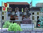
Homage to my town, scenery built mainly with existing objects, buildings by sintax and few experiments by GMax. It DOES NOT include any airport, but represents some pictures of Legnano town
Informations: Legnano is a town in north of Italy (approx 25 kmt NW Milan, ref coordinates N45 35.98 E8 54.59), reachable from Casorezzo ultralight airport (closest one) or all the near others of Milan area.
Here was done in 1176 the historical fight of the Alliance Lombarda's city-states against Federico Barbarossa German imperator. Legnano is also well known for his metallurgical and textile industries story.
Contents: rev.1 : down town square with municipal Palazzo Malinverni and S. Magno basilica, skyscraper, one of Olona river's bridges, G. Mari football stadium, Alberto da Giussano circus with related monument, encircled by the eight quarter's flags, F. Tosi and Manifattura industrial buildings, Rail station, external parking and glass building
rev.2 : Courthouse building with Teresa's face bronze statue and some more buidings, Palio hystorical figurants inside the stadium, Carroccio and Alberto da Giussano rider, Small goods train on railroad; S. Magno belltower reviewed, red sky-lights on top of skyscraper and chimney, Chimney smoke
| Filename: | Legnano_scenery__Italy.zip |
| License: | Freeware |
| Added: | 27th March 2011, 02:55:40 |
| Downloads: | 648 |
| Author: | Aldo Della Vedova |
| Size: | 6.83 MB |
| Category: Flight Simulator 2004 - Scenery | |
| CYEN Estevan Saskatchewan Municipal Airport |
|
Images related to this file:
File Description:

CYEN Estevan Municipal airport is situated approximately three miles (6 Km) north of the City of Estevan. CYEN Estevan Muni was constructed using GMAX and represents the airport as it was in the Summer of 2006. It includes all the buildings at the airport, runway signs, addition of some fencing, anda new rotating beacon that is closer to the actual device. CYEN also includes a landclass file to better represent the terrain around the airport, at least as far as the limits of the default landscape will allow.
The airport is home to Sunrise Aviation (which operates the field for the city) and some 26 light aircraft. CYEN handles a wide variety of Canadian and U.S. corporate and charter aircraft given the large oil and coal mining industry in the area. With the U.S. border so close by, CYEN is also the first stop for many U.S. registered aircraft that land to clear customs and refuel.
(This is a re-upload of the scenery to replace the original that was lost in the AVSIM hack. No changes have been made)
| Filename: | CYEN_Estevan_Saskatchewan_Municipal_Airport.zip |
| License: | Freeware |
| Added: | 7th May 2010, 12:47:13 |
| Downloads: | 1,700 |
| Author: | Gregory Putz |
| Size: | 1.67 MB |
| Category: Flight Simulator 2004 - Scenery | |
| LELC Murcia/San Javier, Spain |
|
File Description:
Googly scenery for LELC San Javier, Spain, a medium-sized airport on the Costa
Cálida 17 miles south of Murcia. The airport sees daily scheduled traffic
operated by Canadair Regional Jets and Dash 8 turboprops of Air Nostrum but a
large proportion of the airport's traffic is derived from tourist charter
traffic from operators such as Air Berlin, Easyjet, LTU International and
Ryanair and the airport can accept aircraft as large as the Boeing 767. The
north end of the airport is home to the Spanish Air Force Academy.
Flight Simulator 2004 has made little provision for traffic with facilities only
for general aviation aircraft and this scenery seeks to redress the situation.
The scenery does not purport to be ultra-accurate. Based on high quality
satellite imagery from Google Earth, the layout is proportionally correct but the
added airport features, such as buildings, are built from default Microsoft objects
and add-on libraries so will not look exactly like the real thing.
You are not obliged to download and install any additional scenery libraries,
but to enjoy this scenery in its entirety, you may wish to. It will work fine,
with or without.
| Filename: | LELC_MurciaSan_Javier_Spain.zip |
| License: | Freeware |
| Added: | 6th April 2008, 20:35:29 |
| Downloads: | 3,169 |
| Author: | John hinson |
| Size: | 20.51 KB |
| Category: Flight Simulator 2004 - Scenery | |
| Shea Field CSF7, Casselman Ontario Canada |
|
Images related to this file:
File Description:
Shea Field is a recently-licensed privately-owned grass airfield in Ontario, 25 miles southeast of ottawa, and south of Highway 417. When I visited I was greeeted by the horse, peering around the end of it's stable shed at the corner of apron and runway. I walked over to the house and rang the doorbell and the dog said hello and that exhausted all social contact. The hangar is large but I have no idea what is inside. There was one plane parked on the apron with a skirt of uncut grass so presumably it hasn't flown for a few months. It was a Citabria in what looked like good condition; I don't have a Citabria to park there so I put a Cub. My favourite building is the old barn, leaning to one side as if seeking support for an elbow. To the north there are some farm sheds and grain silos, and to the northwest a tall mast; avoid it. To find the field without a gps follow the 417 and look for the tall mast just west of a major highway wiggle.
| Filename: | Shea_Field_CSF7_Casselman_Ontario_Canada.zip |
| License: | Freeware, limited distribution |
| Added: | 5th August 2012, 13:35:12 |
| Downloads: | 214 |
| Author: | Roger Wensley |
| Size: | 2.62 MB |
© 2001-2026 AVSIM Online
All Rights Reserved
Privacy Policy |