
Where Flight Simulation Enthusiasts Gather from Around the World!
AVSIM Library - Search Results

| Category: Flight Simulator 2004 - Scenery | |
| CYEG Edmonton International |

|
File Description:
Re-upload. Based on aerial and ground photos. The main terminal and cargo area buildings were all replaced. The aprons were modified to be more accurate and the smaller cargo area taxiway was added. All the usual goodies are included. V2 is a complete replacement for V1. Due to a nasty bug in EZ-Scenery (since eradicated), the entire V1 scenery was misaligned. That has been fixed. Incorrectly sized objects on the cargo ramps have been fixed. The commuter airline parking at the north side of the main terminal has been corrected to make it more like the real thing. V1.1, which contained just the ramp lighting, has been incorporated into V2.
One significant change is that there are now two versions of the scenery, V2 and V2a. V2, like V1, has static aircraft parked at the cargo ramps. In V2a the static aircraft have been removed so ai cargo planes can park at the cargo ramps. V2a of the AFCAD file has cargo parking spaces added.
| Filename: | CYEG_Edmonton_International.zip |
| License: | Freeware |
| Added: | 21st June 2010, 11:09:00 |
| Downloads: | 12,721 |
| Author: | Sidney Schwartz |
| Size: | 2.49 MB |
| Category: Flight Simulator 2004 - Scenery | |
| Alaska South Slope 11; Brevig Mission KTS |
|
Images related to this file:
File Description:
There are four main northwestern Alaska towns which are serviced by Alaska Airlines, and from which local flights spread out. The northernmost is Barrow. Southwest of Barrow is Kotzebue, then Nome, and the furthest south is Bethel (not yet made). This is the fourth in a series for local flights from Nome, and it is on the coast around 50 miles east of Wales, and 60 miles northwest of Nome. There are two other airfields around a large lagoon that is almost totally enclosed from the sea, and Brevig Mission is on the northern shore, just 12 miles northeast of the already-posted Port Clarence. Brevig Mission has a populaton that has risen to 390 in recent years. Tollef Brevik was a Lutheran missionary who was both a pastor and teacher for the Inuit in the area from 1894 onward, travelling from community to community but based in Teller, 6 miles southeast. the village now called Brevig Mission was founded at a later date (unknown to me) and took his name. The airstrip is just east of the village, with two gravel runways; 11-29 which is 3,600 feet of gravel and 04-22 which is 2,600 feet and with PAPI on 22. The AI is the usual for this area, Bering and ERA with some GA and cargo by Everts.
| Filename: | Alaska_South_Slope_11_Brevig_Mission_KTS.zip |
| License: | Freeware, limited distribution |
| Added: | 25th October 2016, 20:52:56 |
| Downloads: | 198 |
| Author: | Roger Wensley |
| Size: | 2.55 MB |
| Category: Flight Simulator 2004 - Scenery | |
| Coffs Harbour (YSCH), NSW, Australia |
|
File Description:
Coffs Harbour Regional Airport (YSCH) FS2004
********************************************
Coffs Harbour airport, located roughly halfway between Sydney and Brisbane on the East coast of Australia, is owned and operated by Coffs Harbour Council. They took over the airport in the early nineties and after a massive expansion plan including widening the runway to handle jets up to a Boeing 767 and building a new terminal at a cost of $4 million dollars. This terminal was opened in November 2000 and should handle the expanding traffic for the next 10 years. At present over 200,000 passengers pass through the terminal.
The scenery re-creates the entire airport for FS2004 including the new terminal, old terminal, all of the ga hangars, flying school, airport tower and many more structures. All modelling was carried out using textures from photographs taken on site to ensure an authentic result. In addition the harbour at Coffs Harbour has been modelled as well as Mutton Bird Island that was missing completely in the default. To conserve frame rates the harbour has not been fully detailed but is accurate in placement and looks realistic on an approach to runway 21.
AFCAD file and traffic tools file is included to populate the airport with additional AI traffic. Also contains three sample flights, which can be selected from the flight simulator select flight menu.
| Filename: | Coffs_Harbour_YSCH_NSW_Australia.zip |
| License: | Freeware |
| Added: | 2nd July 2004, 20:08:19 |
| Downloads: | 4,999 |
| Author: | John Ross |
| Size: | 8.17 MB |
| Category: Flight Simulator 2004 - Scenery | |
| LFRD2004 Dinard/St-Malo VFR Scenery |
|
Images related to this file:
File Description:
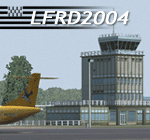
LFRD is a regional airport in Brittany, France. This scenery was created entirely with GMax and the latest Microsoft compilers. Everything was made to ensure maximum framerate while giving maximum visual impact, even on humbler machines. This scenery will run just as fast as the default one (which is very bare) with your current settings, even though there are literally thousands of houses, buildings, trees and a detailed airport.
This is a complete package:
-SRTM local mesh with custom coast trimming
-Custom phototexture (200sq km), with seamless blending into FS9 standard landclass
-Full autogen with custom local texture
-Custom landclass and waterclass
-AFCAD2 file with parking codes
-Custom Hi-res photographic textures at airport.
-Gmax buildings and xml librairy objects.
It was made by a real life pilot and is totally aimed at recreating the feeling of being there, not so much on the ground (after all, this is a FLIGHT simulator), but at circuit altitudes. This is not about recreating an airport in all its glorious details at the cost of framerate, but instead an exercise in balancing visual cues and details as viewed from up there to make it 'as real as it gets' within the limits of FS9. Scenery made by Vauchez (http://mapage.noos.fr/euro_vauchez/)
| Filename: | LFRD2004_DinardStMalo_VFR_Scenery.zip |
| License: | Freeware, limited distribution |
| Added: | 28th April 2010, 18:06:05 |
| Downloads: | 46,559 |
| Author: | Etienne Vauchez |
| Size: | 10.55 MB |
| Category: Flight Simulator 2004 - Scenery | |
| Whati CEM3 in the Northwest Territories, Canada |
|
Images related to this file:
File Description:
Whati is a village at the southern end of Lac La Martre, a smaller lake (only by Canadian standards, at over 40 miles long) halfway between the Great Slave Lake and the Great Bear Lake and around 100 miles north of Yellowknife. The North West Company established a trading post there in 1793, and this was the centre for local trading in the area for 100 years until a post was opened by the Hudson Bay Company on the Great Slave Lake. The current population is in the region of 520. There is no graded road access and access is by boat or air. The main local economy revolves around hunting and fishing, with efforts being made to increase tourism amid the wilderness and the wildlife. The airfield is just over a mile east of the village, with a runway of around 3,400 feet of gravel aligned 09-27 as of 2010, with PAPI at both ends and lit. There are scheduled flights from Yellowknife by Air Tindi, included in the AI, and some GA. The terminal building is similar to that of Lutselk'e, but with a different colour scheme and with solar panels on the roof. It appears that they repaint the sign on the front of the building with a different wording every time; the one I have used is one of three that have existed in the last few years. The photos I had originally were taken in the winter, with snow. Seeing it in the summer I discovered that my version of the building is not at the right level above the ground by about a foot, or 30cm. I was too lazy to make it again, which was the only way to get it right and still have it throw a shadow on the ground. This scenery modifies the lake shore, corrects levels for land and lake, and adds the village and a connecting road in addition to the airport. A note here about my scenery making. There will not be many more to follow this as I am almost at the end of the photos I either took or found for scenery purposes, plus I expect to move on from FS9 at some point during next year.
| Filename: | Whati_CEM3_in_the_Northwest_Territories_Canada.zip |
| License: | Freeware, limited distribution |
| Added: | 15th December 2019, 19:18:29 |
| Downloads: | 148 |
| Author: | Roger Wensley |
| Size: | 4.25 MB |
| Category: Flight Simulator 2004 - Scenery | |
| Abruzzo-Molise L'Aquila, Italy |
|
Images related to this file:
File Description:
Abruzzo & Molise, Italy, Photoreal Scenery (26 june 2007).
Freeware scenery for FS2004.
All files of my scenery ABRUZZO & MOLISE: Abruzzo & Molise 1 - Campobasso.zip
Abruzzo & Molise 2 - Pescara.zip
Abruzzo & Molise 3 - Gran Sasso.zip
Abruzzo & Molise 4 - L'Aquila.zip
Author: Angelo Lanzillotta
e-mail: [email protected]
This photoreal scenery is based on aerial photos grabbed at the resolution of 5 meters per pixel (the same used in FS2004- works in FS 2002 too). I worked hard on these photos to obtain a final product with the real colours and the real positions for all parts of the landscape: if you have any comments or suggests, feel free to email me.
Every single part of this scenery can be used also as a standalone product, so it's not necessary to download all 4 parts of my big scenery.
However i strongly suggest to use all parts in order to obtain a complete photoreal look of this beautiful italian landscape, with famous mountains like Gran Sasso and Maiella.
INSTALLATION: 1) extract the files in a directory of your choice using the option: Use folder names.
2) Open FS and add the scenery to the scenery library (order isn't important).
For best results, use this scenery in association with Pietro Mauri Italymesh2004.
DISCLAIMER
This scenery is released as freeware, so nobody can make money with it.
You cannot include this scenery in any software collection or web site without written permission of author.
You can add objects and autogen (i had no time to work on them).
This software can be used only as FSX/FS2004/FS2002 scenery: no other use is allowed.
I accept absolutely no responsibility for your use of this software.
Re Uploaded in Oct. 2012 by Roberto (Tenex) Italy Terni(TR)
| Filename: | AbruzzoMolise_LAquila_Italy.zip |
| License: | Freeware, limited distribution |
| Added: | 10th October 2012, 22:37:18 |
| Downloads: | 1,094 |
| Author: | Enzo Lanzillotta |
| Size: | 87.93 MB |
| Category: Flight Simulator 2004 - Scenery | |
| VFR of Lario, Area B1 - Como lake, Italy |
|
Images related to this file:
File Description:

This is the second scenery of the "VFR of Lario" project that follows the previous LagoComo_A1, made with photorealistic terrain (multiseason & night) and with some 3D GMax realistic objects. With this scenery there are also enclosed the great realistic meshes that cover all the Como lake area.
Information: Como's lake (called Lario), is placed in the north of Italy, closed to the Helvetic border. This second scenery covers approximately an area of 7.5x6 kmt, from Bosco di Falmoira/Rondago (NW) to Nesso (NE), and from Balerna/Chiasso (SW) to monte Bolletto (SE), and includes some details of the towns around the lake as Cernobbio (pier, Villa Erba and Convention Center, Villa d'Este, Akzo Nobel buildings), Moltrasio (pier), Carate Urio (pier), Laglio (villa Oleandra), Brienno (buildings and pier), Nesso (pier), Careno (pier), Faggeto Lario (pier), Torno (building and Pier), Blevio (pier).
Contents: several piers and small docks, motor ships and boats, an animated hydrofoil; some other buildings (GenericBuilding system) and trees widespread all over the scenery. Review of Brunate's funicolar and Castel Baradello, due to updated meshes.
| Filename: | VFR_of_Lario_Area_B1__Como_lake_Italy.zip |
| License: | Freeware |
| Added: | 26th January 2012, 15:23:57 |
| Downloads: | 1,946 |
| Author: | Della Vedova Aldo, Daniele Lanfranchi, Diego Caligiuri, Gian Mario Verga |
| Size: | 36.15 MB |
| Category: Flight Simulator 2004 - Scenery | |
| Alaska South Slope 8; Shishmaref PASH |
|
Images related to this file:
File Description:
There are four main northwestern Alaska towns which are serviced by Alaska Airlines, and from which local flights spread out. The northernmost is Barrow. Southwest of Barrow is Kotzebue, then Nome, and the furthest south is Bethel (not yet made). This is the first in a series for flights from Nome, and it is Shishmaref, 125 miles north of Nome on the far side of the Seward Peninsula.
Shishmaref is a village on one of a string of islands off the northern shore of the Seward Peninsula, with a population of around 560. Like other similarly-sited villages (Kivalina, for instance) it is feeling the effects of coastal erosion and there are plans for a relocation, eventually. The airfield is just beside the village, with a runway of just under 5,000 feet of lit asphalt aligned 05-23, with PAPI on both ends. There are scheduled flights by Era (now renamed Ravn) and by Bering Air, both of them originating in Nome. The AI includes these flights along with Everts Air and GA.
| Filename: | Alaska_South_Slope_8_Shishmaref_PASH.zip |
| License: | Freeware, limited distribution |
| Added: | 20th October 2016, 04:37:02 |
| Downloads: | 212 |
| Author: | Roger Wensley |
| Size: | 2.32 MB |
| Category: Flight Simulator 2004 - Scenery | |
| Sanikiluaq CYSK in Hudson Bay, Nunavut, Canada |
|
Images related to this file:
File Description:
Sanikiluaq is a village 740 or so inhabitants at N56 30, W79, which means in the southern part of Hudson Bay, close to James Bay. The village is at the north end of Flaherty Island, which is the largest of the Belcher Islands. You might fly there from La Grande Riviere in Quebec (200 miles SSE) or maybe from Moosonee in Ontario at the bottom of James Bay (350 miles SSW). Sanikiluaq village does not feature in FS9, so the first thing to do was to add it; it is the right shape and with around the right number of houses on the right streets but as I wasn't going to model 100+ individual houses just think of it as a hand-made auto-generated village. I also had to move the airfield over beside the river, so there is a DELETE file and a GRASS file and a ROADS file, as well as an AFCAD for AI and a scenery file. And AI for a visiting Air Inuit plane.
| Filename: | Sanikiluaq_CYSK_in_Hudson_Bay_Nunavut_Canada.zip |
| License: | Freeware, limited distribution |
| Added: | 11th October 2010, 23:15:41 |
| Downloads: | 515 |
| Author: | Roger Wensley |
| Size: | 2.21 MB |
| Category: Flight Simulator 2004 - Scenery | |
| Herb's Field C417 near Ottawa in Ontario, Canada |
|
Images related to this file:
File Description:
Herb's is on the 417 between Ottawa and Montreal at the junction with highway 34, which is south of Hawkesbury. Herb's is a truckstop and a repair garage and a restaurant and a gas station, and is still (but only just!) an airfield. Which is to say there is still a runway, some 1,200 feet long and 30 feet wide. Do not go in your Cessna 172 as only the northern half is usable, and that after inspection from the air for any obstacles, parked cars, dogs, and similar obstacles. The southern half is the way in for trucks and cars, so make sure you can stop well before the ex-hangar which is now for truck repairs only. The planes all belonged to Herb's father, and even a casual inspection will reveal that they haven't moved for some time. If there is anything using the service road immediately to the north of the runway go around again, you won't be able to clear a vehicle and then land on the threshold.
| Filename: | Herbs_Field_C417_near_Ottawa_in_Ontario_Canada.zip |
| License: | Freeware, limited distribution |
| Added: | 14th February 2010, 14:39:56 |
| Downloads: | 386 |
| Author: | Roger Wensley |
| Size: | 2.02 MB |
© 2001-2026 AVSIM Online
All Rights Reserved
Privacy Policy |