
Where Flight Simulation Enthusiasts Gather from Around the World!
AVSIM Library - Search Results

| Category: Flight Simulator 2004 - Scenery | |
| CYVQ - Norman Wells - Northwest Territories, Canada |

|
Images related to this file:
File Description:
Norman Wells is the last of a series of airfields that are along (or close to) the Mackenzie River and in the Northwest Territories. It is 290 miles southeast of Inuvik and just 40 miles northwest of Tulita. The town growth was accelerated by the discovery of oil in the 1930's and the building of a small refinery in 1937, which is included here; there are now around 840 folks living in the town. The airport is adjacent to the town and has just under 6,000 feet of asphalt runway. North Wright Airways is headquartered there and this is reflected in the AI, which is for all of the newly-posted Mackenzie River postings. There is also helicopter AI, Canadian North, First Air, and there are GA flights. There is a mandatory frequency and the Norman Wells tower is manned 24 hours a day so you will follow atc instructions. In real life the terminal is on two levels; this steep change in terrain level is not possible to achieve in FS9 so although I made it as a two level terminal (ready for the FSX version?) it is here modified into a single level building. There are several "taxiways" which lead to the runway but are without hold short markings. These have been shown but are not included as AI routes. The helicopters presumably hover-taxi to the runway across grass (and snow) in real life; the AI helicopter will taxi on wheels. Note that at mixed-use airports planes and helicopters all follow the same rules of procedure.
| Filename: | CYVQ__Norman_Wells__Northwest_Territories_Canada.zip |
| License: | Freeware, limited distribution |
| Added: | 12th July 2014, 11:22:10 |
| Downloads: | 472 |
| Author: | Roger Wensley |
| Size: | 14.57 MB |
| Category: Flight Simulator 2004 - Scenery | |
| CYYQ - Churchill Port & York Factory - Northern Manitoba, Canada |
|
Images related to this file:
File Description:
The main part of this scenery installs the Port of Churchill and the grain silos. Churchill CYYQ has been made by Sidney Schwartz, and this also adds AI and slightly modifies his parking to make a space big enough for Buffalo's C46. Churchill is in northern Manitoba, on the Churchill River where it empties into Hudson Bay. The town is accesible by air, by boat (once the winter ice melts) and most importantly by rail from the south. Grain from the Canadian prairies is hauled north and stored in Churchill for export to Europe by a sea route that is significantly shorter than any other, and there is a grain carrier included in the AI. Today there are perhaps 810 people living in Churchill, a slowly declining number. There are also a number of impressive polar bears. There was another port south of Churchill, but it was never completed, never connected to a railroad track, and never used. It was called Port Nelson, and was at the mouth of the Nelson River. Nearby, on the Hayes River, there is an old trading post called York Factory, built in 1684 and preserved as part of the living history of the north of Canada. The second scenery is for this, and for the nearby tourist camp called Silver Goose Lodge, which as the name suggests is for hunters. The large grassy area alongside the fort was for the trappers to camp on when they all arrived in early summer to trade the furs for goods.
| Filename: | CYYQ__Churchill_Port__York_Factory__Northern_Manit.zip |
| License: | Freeware, limited distribution |
| Added: | 23rd July 2014, 02:26:04 |
| Downloads: | 542 |
| Author: | Roger Wensley |
| Size: | 3.69 MB |
| Category: Flight Simulator 2004 - Scenery | |
| Lake Hood LHD and Z41 in Anchorage Alaska UPDATED |
|
Images related to this file:
File Description:
This is an updated version that is complete in itself and which greatly upgrades Lake Hood Airstrip Z41 and also makes minor modifications to LHD. Lake Hood is right next door and to the north of Ted Stevens Anchorage International Airport, and there is a second airfield on the north side of the lake called Lake Hood Airstrip. The airstrip is coded Z41, the International is PANC, and Lake Hood itself is LHD. You will need Ultimate Terrain Alaska Canada for this to work, and you should also download and install Anchorage International (verson 4?) by William Morgan of FRFStudio. LHD/Z41 includes a fair proportion of the 780 float planes that are based there and which make Lake Hood the largest and busiest float plane base in the world, averaging 190 flights per day during the year and a lot more than that per day during the summer months. There is fuel at two places on the lake, and a lot of maintenance help available. The documentation showing the VFR routes to Lake Hood is also included in the Lake Hood VFR procedures folder, and basically, if you listen to the ATC chatter, planes either route via the Ball Park or the Gravel Pit, which gets abbreviated to something like "You want the park or the gravel?" which wouldn't mean a whole lot to an unrehearsed stranger. Unfortunately FS doesn't reach that level of sophistication, but you can still take the right route. There is a google marked map showing the locations of the checkpoints.
| Filename: | Lake_Hood_LHD_and_Z41_in_Anchorage_Alaska_UPDATED.zip |
| License: | Freeware, limited distribution |
| Added: | 18th July 2010, 08:16:48 |
| Downloads: | 981 |
| Author: | Roger Wensley |
| Size: | 9.25 MB |
| Category: Flight Simulator 2004 - Scenery | |
| Tofino CYAZ 2012 |
|
Images related to this file:
File Description:
I've always had a particular fondness for Tofino CYAZ, located on the west coast of Vancouver Island. I made my first Tofino scenery in 2005 using Lago's FSE, and an updated version in 2006 using EZ-Scenery. Neither of those included custom models. This final version is a complete, from-the-ground-up rebuild. Every building and many of the other scenery objects are custom made based on photos and using photo textures. (The images in the "Tour" folder will take you on a tour of the real and virtual airport.) In the time since the first two virtual versions were made, a new terminal building has been added to the east ramp at the real Tofino, along with some new hangers, and the scenery includes these changes. Tofino has an NDB instrument approach (CYAZ NDB A.pdf), but night operations are not allowed. For this reason the new terminal building has no night lighting. The golf clubhouse restaurant and pro shop are open after dark for your shopping and dining pleasure. This scenery represents many hours of work...I hope you enjoy it.
| Filename: | Tofino_CYAZ_2012.zip |
| License: | Freeware |
| Added: | 19th August 2012, 14:33:09 |
| Downloads: | 649 |
| Author: | Sidney Schwartz |
| Size: | 10.14 MB |
| Category: Flight Simulator 2004 - Scenery | |
| KNUQ - Moffett Federal Airfield - Mountain View - California (USA) |
|
Images related to this file:
File Description:
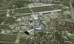
Known originally as Naval Air Station Sunnyvale after its christening in 1933, Moffett Field was renamed in 1942 in honor of Rear Admiral W.A. Moffett a founder of the Navy's Lighter than air program. By this time the LTA program had been reduced to the use of smaller dirigibles for scouting and anti-submarine work but the airfield remained immensely important as a fixed-wing facility due to it's strategic location between Seattle and San Diego. The Ames Research Center established before the war also blossomed into a major post-war aeronautical research and development center due in part to its highly advanced wind tunnel facilities. After the Second World War, Moffett Field developed into a West Coast hub for Patrol and ASW operations against encroaching Soviet missile boats. The NASA presence at Moffett began as early as 1939 with the establishment of the Aames Research Facility and evolving into the sophisticated R&D complex it is today. This particular scenery package attempts to represent the base more or less as it is today.
| Filename: | KNUQ__Moffett_Federal_Airfield__Mountain_View__Cal.zip |
| License: | Freeware |
| Added: | 21st August 2014, 10:41:53 |
| Downloads: | 1,349 |
| Author: | John Stinstrom |
| Size: | 12.36 MB |
| Category: Flight Simulator 2004 - Scenery | |
| Grafton District Airport - NSW Australia |
|
File Description:
A delighful small airport approximately 80 nautical miles from Coffs Harbour and a slightly shorter distance to Ballina and Lismore. This makes a good stopover for hopping down the east coast of Australia.
The size of the airport has allowed me to put in that extra detail which makes to terminal and surrounds very much "as in real life". Photographic textures are used throughout for the buildings and even the trees are hand made macros from photographs at the airport.
AFCAD and Traffic Tools files are included to add extra AI traffic. For that reason and because of limited apron space no static planes have been used.
The scenery concentrates on adding a realistic terminal to the airport whilst leaving much of the default runway detail unchanged. Changes which have been made to the runway include tidying up the taxi way fillets so the markings do not appear to be on the grass and the windsocks have been replaced with macros designed to resemble the Grafton windsocks. Other than that the airport merges into the default scenery without the usual "green oasis" effect.
| Filename: | Grafton_District_Airport__NSW_Australia.zip |
| License: | Freeware, limited distribution |
| Added: | 5th December 2003, 04:29:01 |
| Downloads: | 2,546 |
| Author: | John Ross |
| Size: | 2.1 MB |
| Category: Flight Simulator 2004 - Scenery | |
| Kimmirut CYLC on Baffin Island in Nunavut, Canada |
|
Images related to this file:
File Description:
Kimmirut is a village of some 400 folks at the southern end of the southwest-facing coast of Baffin Island, 75 miles southwest of Iqaluit. It is on the northern side of the Hudson Strait between Baffin Island and Quebec, opposite Kangiqsujuaq on the Quebec shore. The airfield is served by two flights per week, one on Monday and another on Friday, only half fueled to be able to use the 1,899' of gravel 75' wide runway. The terminal building is small and there is a garage building for airport maintenance vehicles (snow clearing). There are some nearby buildings that I have included. The village is "represented" (not "modeled") with approximately the right shape and road layout. Take enough fuel so that you can leave again, as fuel is no longer for sale here. The Cape Dyer bgls are to make a small correction, it is explained in the text. I will not be posting new sceneries in the future and this is the last one for Avsim; it completes Baffin Island.
| Filename: | Kimmirut_CYLC_on_Baffin_Island_in_Nunavut_Canada.zip |
| License: | Freeware, limited distribution |
| Added: | 25th July 2011, 17:36:57 |
| Downloads: | 534 |
| Author: | Roger Wensley |
| Size: | 2.53 MB |
| Category: Flight Simulator 2004 - Scenery | |
| Health Bay CAD7 in British Columbia, Canada |
|
Images related to this file:
File Description:
This is the fourth in a series of new and renovated float bases in BC. Health Bay is a small village on the west coast of Gilford Island, just 13 miles northwest of Minstrel Island (the previous post in this series). There is no fuel or oil available. The AI is a further adaptation of the original CF36 AI and involves a Baxter Beaver flying from Port Hardy on a round trip in the area through Port McNeill, Health Bay, Echo Bay, and Sullivan Bay. At Health Bay the AI appears to work for both landing and takeoff, though landing will still depend on wind direction. I have played with circuit height and runway length at Minstrel Island and there are improvements, so there is a Minstrel Island replacement bgl. All of these float bases can be installed together in the same folders, with a saving in duplicate textures. So a series called BC Floats (or whatever you want to call it) or individually installed float bases; your choice. The next in the series will be Echo Bay, shown in an included screenshot.
| Filename: | Health_Bay_CAD7_in_British_Columbia_Canada.zip |
| License: | Freeware, limited distribution |
| Added: | 18th January 2017, 01:15:57 |
| Downloads: | 172 |
| Author: | Roger Wensley |
| Size: | 4.63 MB |
| Category: Flight Simulator 2004 - Scenery | |
| Ocean Stations for Multiplayer Use |
|
File Description:
I've produced this scenery to provide all of the Ocean Stations I know about in the 1950's and 1960's. There is a Coast Guard ship on station (painted in the colors of the USA), an NDB to give you a bearing to the ship, a way to contact the ship using voice (you can get your position relative to the ship this way), and a DME for distances further than the limited 30 NM FS ATC gives you (normal communications would reach about 100 NM). You can also get a weather report, and if you are a seaplane you can be cleared to land. If you are a landplane, I guess this would constitute permission to ditch...
I want to give a big thank you to Mitsuya Hamaguchi (hama) for graciously supplying the ship used in this scenery.
This version uses scenery ships, which will not disappear in multiplayer. There is only a US ship, however. For the AI ship version (with ships of several countries) download OceanStations.zip instead.
| Filename: | Ocean_Stations_for_Multiplayer_Use.zip |
| License: | Freeware, limited distribution |
| Added: | 6th May 2008, 03:51:56 |
| Downloads: | 543 |
| Author: | Tom Gibson |
| Size: | 405.16 KB |
| Category: Flight Simulator 2004 - Scenery | |
| Taihape Airfield, New Zealand. NZVR. |
|
File Description:
Welcome to Taihape, a small rural airfield in the Rangitikei region of the central North Island of New Zealand.
The airfield is situated 1 nautical mile south-west of the small town of Taihape, and is home to Rangitikei Air Services, and also home to a couple of the Wanganui Aero Work agricultural Fletcher aircraft.
Wanganui Aero work is the largest agricultural aircraft fleet operator in New Zealand.
This scenery is designed specifically for use with the GNZLAP Special AI Release "A Flock of Fletchers",by Charl Du Toit.
This AI package is freely available here on avsim, filename....... GNZLAPA1.zip .
This scenery is REQUIRED for the AI package to work properly. Scenery requires some EZ Scenery Object sets (see INSTALL instructions for details).
| Filename: | Taihape_Airfield_New_Zealand_NZVR.zip |
| License: | Freeware, limited distribution |
| Added: | 6th September 2008, 02:55:22 |
| Downloads: | 787 |
| Author: | Lawrie Roache |
| Size: | 1.42 MB |
© 2001-2026 AVSIM Online
All Rights Reserved
Privacy Policy |