
Where Flight Simulation Enthusiasts Gather from Around the World!
AVSIM Library - Search Results

| Category: Flight Simulator 2004 - Scenery | |
| Oregon and British Columbia Soaring Scenery |

|
File Description:
FS2004 Oregon and British Columbia Soaring Scenery
These files adds some thermals to default Microsoft Scenery for below cities of British Columbia Canada and Oregon,USA:
1.Vancouver City - Evergreen Airport(ICAO-59S)
2.Vancouver City - Pearson Airport(ICAO-KVUO)
3.Scappoose City - Chinook Ultralight Airport(ICAO-52OR)
4.Mcminnville City - Mcminnville Airport(ICAO-KMMV)
5.Salem City - Landsem Air Field(ICAO-4OR7)
6.Albany City - Albany Muni Airport(ICAO-S12)
7.Eugene City - Mahalon Sweet Airport(ICAO-KEUG)
8.Oakland City - Heavens Gate Airport(ICAO-2OR4)
9.North Bend City - Sunnyhill Airport(ICAO-1OR0).
10.Flight Plan and Nav. Log from Evergreen to Sunnyhill Airports.
It is freeware.
By Francisco Vargas.
E-mail:[email protected]
| Filename: | Oregon_and_British_Columbia__Soaring_Scenery.zip |
| License: | Freeware |
| Added: | 5th November 2005, 21:22:15 |
| Downloads: | 759 |
| Author: | Francisco Augusto Vargas Carneiro |
| Size: | 128.85 KB |
| Category: Flight Simulator 2004 - Scenery | |
| Europe SRTM mesh part 05: Poland |
|
File Description:
Europe SRTM LOD9 mesh part 5 of 13: Covers all parts of Poland north of 50'N. This Europe SRTM project was optimized for the lowest HDD space use: Each part matching exactly the boundaries of its neighbors, you'll have a complete coverage of Europe without gap or overlapping scenery.
Based on SRTM Data v1 and v2 (3 arcsec, 90m) and sampled to LOD9 resolution (90m). Each SRTM tile was carefully checked and repaired with Blackart v4.02: water areas are now flattened (lighter mesh), and SRTM voids were treated taking advantage of Blackart's sophisticated interpolation algorithm. When required, biggest voids were patched with oversampled SRTM 30 arcsec data and/or manual input.
| Filename: | Europe_SRTM_mesh_part_05_Poland.zip |
| License: | Freeware, limited distribution |
| Added: | 23rd December 2009, 10:34:50 |
| Downloads: | 17,168 |
| Author: | Yohann Baptiste |
| Size: | 35.01 MB |
| Category: Flight Simulator 2004 - Scenery | |
| Dillingham Airfield, HI |
|
File Description:
FS2004 Scenery-Dillingham Airfield, Oahu, HI (PHDH) is a general aviation joint-use facility on the north shore of Oahu near the community of Waialua. The airfield has one 5,000' by 75' runway, a State-operated UNICOM (air traffic advisory) facility, several hangars, and a tie down area for recreation aircraft, but no other facilities. Air traffic is limited to daytime operations by small single-engine and light twin-engine aircraft, sailplanes, ultra-lights aircraft, and helicopters. Traditionally, the airfield has been used mainly for recreation, such as glider soaring, hang-gliding, parachuting, and sky jumping. A taxiway extension will be built in 2005. Created with EZ Scenery. PLEASE READ THE README FILE!
| Filename: | Dillingham_Airfield_HI.zip |
| License: | Freeware, limited distribution |
| Added: | 29th May 2007, 04:02:32 |
| Downloads: | 2,022 |
| Author: | John B. Loney, Jr. |
| Size: | 802.31 KB |
| Category: Flight Simulator 2004 - Scenery | |
| Canyonlands National Park, The Maze-South, Utah, Photo-Scenery (FSX too) |
|
Images related to this file:
File Description:
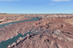
This is a re-upload of a package that was corrupted during the crash of the AVSIM library. This is the fourth package of the Arches/Canyonlands area. It covers the area southwest and including the confluence of the Colorado and Green Rivers. From there you can fly down Cataract Canyon which is famed for its premium whitewater rafting oportunities. Or explore the Maze (the area west of the Green and north of the Colorado River) with it's labyrinth of canyons and colorful sandstone formations. The scenery extends west to Hite (UT03) on Lake Powell. Brings the total Southern Utah coverage to 14.000 sq km in 4.7m/pix quality. YourDonation@Work: Dedicated to Patrick, Hideyuki and Art. Thanks!
| Filename: | Canyonlands_National_Park_The_MazeSouth_Utah_Photo.zip |
| License: | Freeware, limited distribution |
| Added: | 31st December 2009, 22:33:46 |
| Downloads: | 2,080 |
| Author: | Gottfried Razek - blueskyscenery.com |
| Size: | 95.67 MB |
| Category: Flight Simulator 2004 - Scenery | |
| Guangdong Pearl River Delta Landclass - China |
|
File Description:
These are landclass files of the Pearl River Delta area, located in the south of China's Guangdong province.
This area is one of the biggest metropolitan areas (or megacity) in the world today, and as it was poorly represented in FS2004, I decided to 'map' it using EZ-landclass and images from Google Maps.
The area that was mapped stretches as far north as the New Bayiun Airport, all the way to the islands south of Hong Kong, and to the mountain ranges east and west of the Delta; with big cities included being: Guangzhou, Foshan, Dongguan, Jiangmen, Huizhou, Shenzen, Zhongshan, Zuhai, Macau & Hong Kong.
Only tested in FS9 but should work in FSX as well.
| Filename: | Guangdong_Pearl_River_Delta_Landclass__China.zip |
| License: | Freeware |
| Added: | 17th April 2016, 19:11:40 |
| Downloads: | 486 |
| Author: | Leonardo Santos |
| Size: | 6.92 KB |
| Category: Flight Simulator 2004 - Scenery | |
| Schiphol 5th Main Runway 'Polderbaan' V2.1 |
|
File Description:
Amsterdam's airport Schiphol (EHAM) has a new runway, it's the 5th main runway
bringing the total on 6 runways. It's the thirth north-south runway, and will
go into limited (night time) service on 20 feb 2003. At the same till al three
runways will be renummerd, this new runway will be designated 18R-36L, 01L-19R
will be changed to 18C-36C and 01R-19L to 18L-36R. This scenery adds the new
runway, which is called "Polderbaan" and it's taxiway-system. If you're flying
on VATSIM into EHAM from now on, this scenery is A MUST HAVE! Designed to be
used with the default FS2004 scenery. Version 2.1 By Marcel Ritzema
| Filename: | Schiphol_5th_Main_Runway_Polderbaan_V21.zip |
| License: | Freeware, limited distribution |
| Added: | 6th September 2003, 18:58:15 |
| Downloads: | 17,884 |
| Author: | Marcel Ritzema |
| Size: | 790.2 KB |
| Category: Flight Simulator 2004 - Scenery | |
| Alaska/BC Bush Scenery: Edgecombe Lodge, Johnny Mountain Mine, & Bob Quinn Lake |
|
File Description:
My fourth bush scenery in Alaska/British Columbia. This package includes three airstrips: the first runway at Edgecombe Lodge has an unusual inclined profile, located precariously across a ridgeline on Annette Island near Ketchikan. I've also put together a tailor-made NDB Instrument Approach plate for it. The other two, Johnny Mountain Mine and Bob Quinn Lake, are hazardous real-life airstrips along the Iskut River in BC (about 50 miles north of Ketchikan). Includes AFCAD files for FS2004 and FS2002. Although I have modified the terrain to create the runways, Eddie Denney's FS2002 mesh of Alaska is still required as a foundation for this scenery to work. Also requires Gerrish Gray's Tree Library (release 3).
| Filename: | AlaskaBC_Bush_Scenery_Edgecombe_Lodge_Johnny_Mount.zip |
| License: | Freeware, limited distribution |
| Added: | 26th January 2004, 15:42:49 |
| Downloads: | 4,432 |
| Author: | James Belk |
| Size: | 5.64 MB |
| Category: Flight Simulator 2004 - Scenery | |
| Byron Bay, Cape Dyer, Cape Hooper, Dewar Lakes, and Durban Island adapted for the FSGenesis 76m North Canada Terrain Mesh |
|
Images related to this file:
File Description:
These are replacement bgl's to convert five northern Canada fields for use with the FSGenesis 76m terrain mesh for northern Canada. The five are Byron Bay CWBB, Cape Dyer CWFD, Cape Hooper CWFH, Dewar Lakes CWFL, and Durban Island CWFB. These are not stand-alone, and the presumption is that you have already downloaded and installed the previously posted sceneries. The installation consists solely of replacing the existing scenery bgl's with the new. There will be further posts of northern airfields in groups of five, alphabetically, and observations regarding the amendments and any further corrections that are required would be welcomed.
| Filename: | Byron_Bay_Cape_Dyer_Cape_Hooper_Dewar_Lakes_and_Du.zip |
| License: | Freeware, limited distribution |
| Added: | 3rd September 2017, 20:01:55 |
| Downloads: | 73 |
| Author: | Roger Wensley |
| Size: | 3.49 MB |
| Category: Flight Simulator 2004 - Scenery | |
| CNZ3 - Chatham-Kent - Ontario, Canada V1 |
|
Images related to this file:
File Description:
This is partly part of the Small Ontario Fields series. The airport ICAO was changed from CNZ3 to CYCK in November 2012; I have left it as it was. The runway too remains as it was a few years ago. Chatham is located 50 miles east of Detroit and 150 miles southwest of Toronto, between Lake St. Clair and Lake Erie, and the airfield is southeast of the town. There is a single asphalt runway 5,000 feet long and 75 feet wide, aligned 05/23 in FS9 but in fact in real life now 06/24 due to the wandering magnetic north. The apron is on the northern side of the runway at the eastern end, with added taxiways to cater for newer hangars wearing identical colour schemes. There is fuel, runway lighting, some taxiway lights, visitor parking on the grass, and plane maintenance in the large hangar beside the small terminal building on the north side of the apron. There is a train station in the middle of the town, and no scheduled flights to the airport that is 8 miles away; these two facts may be connected. Ditches along the road and around much of the airfield provide separation, which is why the fences are not continuous. If you are on the runway and find your path to the apron blocked by another plane that is stationary at the hold short, continue past the first turnoff to the threshold markers and turn off the runway and wait. The AI plane will then taxi out and you will have a clear path.
| Filename: | CNZ3__ChathamKent__Ontario_Canada_V1.zip |
| License: | Freeware, limited distribution |
| Added: | 27th August 2015, 21:02:59 |
| Downloads: | 341 |
| Author: | Roger Wensley |
| Size: | 9.89 MB |
| Category: Flight Simulator 2004 - Scenery | |
| CYFD Brantford Municipal Airport, Ontario, Canada Version 1.0 |
|
File Description:
I decided to make Brantford a little more like the real thing. I also changed the landclass in the area to make it more realistic as this is where I live. Here are the changes I have made.
--
Modified the airport in AFCAD2 to have the aircraft park on either side of the large apron as they do in real life
, Corrected the runway lengths and added the connector between the runway ends at the north side of the airport
, Added AI Flightplans (see details below)
, Added a landclass update so that the area appears as it does in real life. There are now more farms around the airport as well as in the Burford area. The towns of Burford (my hometown) and Scotland are added, the Long Point Conservation Authority Forest is added to the west of Burford, and the Burford Golf Links appear beside the 403 (divided highway) to the north west of town.
--AI Flightplans
I tried to make the AI traffic as realistic as possible. I have training aircraft doing touch and goes 7 days a week. A few DC-3's have been restored at the airport so I have a DC-3 that flies for testflights on Monday, Wednesday, and Friday from 7am to 12:30pm. A learjet flies to Chicago on business days. It departs at 8am and arrives at 1:59pm. Also, a 182 flies up to Timmins on the weekends. It departs on Saturday at 9am and arrives home on Sunday at 11:36am.
| Filename: | CYFD_Brantford_Municipal_Airport_Ontario_Canada_Ve.zip |
| License: | Freeware, limited distribution |
| Added: | 9th November 2003, 02:46:05 |
| Downloads: | 2,571 |
| Author: | David Voogd |
| Size: | 425.3 KB |
© 2001-2026 AVSIM Online
All Rights Reserved
Privacy Policy |