
Where Flight Simulation Enthusiasts Gather from Around the World!
AVSIM Library - Search Results

| Category: Flight Simulator 2004 - Scenery | |
| Mesa Verde National Park, Cortez (KCEZ), Colorado, Photo-Scenery (FS9 & FSX) |

|
Images related to this file:
File Description:
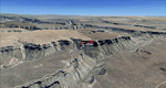
Mesa Verde National Park is famed for its numerous ruins of cliff dwellings built in the 12th century by ancient Pueblo people called Anasazi. Cliff dwellings are highly defensible stone villages situated under alcoves (rock overhangs) along the canyon walls. The largest cliff dwelling in the park is Cliff Palace, which is the largest cliff dwelling in North America. Cliff Palace contained 150 rooms and housed approximately 100 people. Unfortunately you won't see the cliff dwellings from the air, because they are under the cliffs but you will see everything else like all roads, trails and facilities. Very little is known about the Anasazis and the reason for their sudden departure at the end of the 13th century remains a mystery. Theories range from crop failures due to droughts to an intrusion of foreign tribes from the North. The name "Mesa Verde" stems from Spanish explorers seeking for a route from Sante Fe to California. They named the region Mesa Verde (spanish for green table) because of its high, tree-covered plateaus. High resolution versions of this scenery for FS9 and FSX (much sharper, but larger and multiple downloads)
are available at www.blueskyscenery.com/GNB_West2.html . The screenies are taken from the high-res versions, so expect this version to be slightly more blurry. Thanks to Joop Mak for providing custom AFCADs that correct airport layouts so that they align with the photo-textures! They are available at www.blueskyscenery.com/AFCADs.html . YourDonation@Work: Dedicated to David.
| Filename: | Mesa_Verde_National_Park_Cortez_KCEZ_Colorado_Phot.zip |
| License: | Freeware, limited distribution |
| Added: | 1st May 2010, 03:55:31 |
| Downloads: | 1,465 |
| Author: | Gottfried Razek - blueskyscenery.com |
| Size: | 92.87 MB |
| Category: Flight Simulator 2004 - Scenery | |
| VFR of Lario, Area B2 - Como lake, Italy |
|
Images related to this file:
File Description:
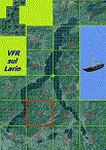
This is the fourth scenery of the "VFR of Lario" project, made with photorealistic terrain (multiseason & night) and with some 3D GMax realistic objects.
Information: Como's lake is in the north of Italy, closed to the Helvetic border. This third scenery covers approximately an area of 7.5x6 kmt, from Nesso/Erno (NW) to Barni (NE), and the ridge east of Monte Bolletto (SW) to Asso/Canzo (SE) and includes some details (GMax) of Pognana Lario NLC pier (fantasy), the A. Volta motorship with the Hydrofoil G. Marconi (both animated). GMax objects as above and other buildings, minor piers and boats together with autogen buildings and trees are fully spreaded on the scenery.
| Filename: | VFR_of_Lario_Area_B2__Como_lake_Italy.zip |
| License: | Freeware |
| Added: | 13th March 2012, 22:06:00 |
| Downloads: | 1,766 |
| Author: | Della Vedova Aldo, Daniele Lanfranchi, Gian Mario Verga, Diego Caligiuri |
| Size: | 11.09 MB |
| Category: Flight Simulator 2004 - Scenery | |
| Landsberg-Airbase |
|
File Description:
This AI-Package contains several beautiful airplanes: Bell-UH1D, Hamburger
Flugzeugbau: C-160 Transall, Heinkel: He-111C, Lockheed: T-33A T-Bird,
Martin: B-26 Marauder, Nord Aviation: ND2501 Noratlas and last not least the
North American: Harvard Mk.41 T-6.
Most of these aircraft perform "Touch and Goes" in the local traffic pattern
at Landsberg-Airbase per attached flightplan and some C-160 Transall go IFR to
Hohn (ETNH, homebase of LTG63), Wunstorf (ETNW, homebase of LTG62), to Sarajewo
(LQSA) and Pristina (LYPR).
All the attached outstanding airplanes have been created by well known designers
(see briefing). My part was just to put them together and to generate an almost
reasonable AI-Flightplan.
| Filename: | LandsbergAirbase.zip |
| License: | Freeware |
| Added: | 7th April 2011, 03:00:00 |
| Downloads: | 1,081 |
| Author: | Klaus Jone |
| Size: | 7.3 MB |
| Category: Flight Simulator 2004 - Scenery | |
| 0AK1 - Anderson Lake - Anchorage, Alaska - USA |
|
Images related to this file:
File Description:
Anderson Lake 0AK1 is in Alaska, less than 2 miles southwest of Wolf Lake, on the north side of Knik Arm. It is , like Wolf Lake, an airpark, with houses and hangars adjacent to a single runway that is 2,200 feet of asphalt aligned 08-26. The runway is lit but the taxiways are not. There are hangars and aprons at the western end that are not "attached" to houses, with an adjacent strip mall. There is also a smaller apron at the eastern end. In the first screenshot Anderson Lake is in the foreground (at the eastern end of the lake of the same name) with Wolf Lake visible behind it.
| Filename: | 0AK1__Anderson_Lake__Anchorage_Alaska__USA.zip |
| License: | Freeware, limited distribution |
| Added: | 17th October 2014, 23:14:46 |
| Downloads: | 386 |
| Author: | Roger Wensley |
| Size: | 3.37 MB |
| Category: Flight Simulator 2004 - Scenery | |
| Hay River CYHY, 2010 |
|
Images related to this file:
File Description:
First established as a permanent settlement in 1892, Hay River is located on the south shore of Great Slave Lake in the Canadian Northwest Territories. Like the territorial capital city of Yellowknife 115 miles to the north on the opposite shore of the lake, Hay River experiences brutal weather conditions, with an average mid winter temperature of minus 27C (minus 18F).
* Aprons and taxiways completely redone to be more accurate.
* Missing ground and water features added, land class adjusted.
* All default buildings replaced. Custom terminal building and other custom objects.
* Roads and railroads in vicinity of airport redone.
* Buffalo Airways AI traffic and static water bomber aircraft.
| Filename: | Hay_River_CYHY_2010.zip |
| License: | Freeware |
| Added: | 12th March 2010, 10:14:00 |
| Downloads: | 1,946 |
| Author: | Sidney Schwartz & Peter Ham |
| Size: | 13.2 MB |
| Category: Flight Simulator 2004 - Scenery | |
| Monument Valley, Kayenta (0V7), Utah/Arizona, Photo-Scenery |
|
Images related to this file:
File Description:

Monument Valley, Kayenta (0V7), Utah/Arizona, Photo-Scenery (FS9 & FSX)
This scenery covers the area from south of the San Juan River down to wonderful Monument Valley and Kayenta, AZ.
It extends my Lake Powell sceneries to the south and brings you another
3.500 sq km in 4.7m/pix quality. To explore the scenery depart from Kayenta (0V7) and head north.
High resolution versions of this scenery for FS9 and FSX (much sharper, but larger and multiple downloads) are available at www.blueskyscenery.com/CNY_South3West.html . The screenies are taken from the high-res versions, so expect this version to be slightly more blurry. YourDonation@Work: Dedicated to Thomas, Don and Eric.
| Filename: | Monument_Valley_Kayenta_0V7_UtahArizona_PhotoScene.zip |
| License: | Freeware, limited distribution |
| Added: | 23rd January 2010, 10:45:32 |
| Downloads: | 2,282 |
| Author: | Gottfried Razek - blueskyscenery.com |
| Size: | 93.49 MB |
| Category: Flight Simulator 2004 - Scenery | |
| Catalonia version II |
|
Images related to this file:
File Description:
Catalonia is my small country located among Spain northeast and France southeast. Its surface it is 32000 km2 in its south area and of about 2000 kn2
In its area north. Your coastal fringe in the Mediterranean is about 630 kms. This is the whole Catalonia.
Their capital is Barcelona where the olympic games was played in recent years.
It is headquarters of the cathedral of Gaudi.It contains 7 big airports 7 airclubs and two seaports. The port of Barcelona is the first tourist port of the mediterranean of the they leave the big tourist cruises.
Airport LEBL is reconstructed with new great terminal
This scenery contents the new airport LEDA in Lleida city
| Filename: | Catalonia_version_II.zip |
| License: | Freeware |
| Added: | 17th March 2010, 23:29:15 |
| Downloads: | 7,102 |
| Author: | Toni Agramont |
| Size: | 74.05 MB |
| Category: Flight Simulator 2004 - Scenery | |
| LFPB 1960 Paris Le Bourget Version 2 |
|
Images related to this file:
File Description:
Le Bourget airport north of Paris is one of the world's oldest airports.
It dates back to the early days of World War One,
when land was seized for a military airfield.
The airport opened for commercial operations in 1919.
Possibly the most significant historical event was
Charles Lindbergh's landing there after his historic
solo transatlantic flight on Mai 21st, 1927.
We have produced this scenery to provide taxiways and details
as they were around 1960 in Paris le Bourget
We've also included new parking to allow the AI aircraft to taxi
correctly at the new (old!) airport.
New in version 2 : Upgraded terminal textures by Rui Cristina
and new custom made hangars.
| Filename: | LFPB_1960_Paris_Le_Bourget_Version_2.zip |
| License: | Freeware |
| Added: | 16th January 2011, 23:13:13 |
| Downloads: | 3,557 |
| Author: | Wolfgang Gersch, Volker Boehme and Rui Cristina |
| Size: | 1.06 MB |
| Category: Flight Simulator 2004 - Scenery | |
| Reanimated NATO-Airbase Pferdsfeld, ETSP (near Ramstein, Germany) including AI-Package and Tools. No FSE required. |
|
File Description:
This Nato-Combat-Airbase, located in Central Germany near Ramstein (Rhein / Mosel
region), was the homebase of JG73 and JaboG35. The airport has been closed in 1994,
was reanimated by Fritz Becker for FS2004 use and I did the rework to make it ready
for AI-Traffic.
The included AI-Package contains the Dornier Do-28, Fiat G91R, Douglas C-47/DC-6B,
McDonnell-Douglas F-4E, Nord-Aviation Noratlas ND2501, North-American T-6, and the
Republik F-84F.
All aircrafts perform "Touch and Go" in the local traffic pattern per attached
flightplan. Note: "Keep the final clear, the Flight Checker is here" (C-47).
Lago's FSE is not required this time.
| Filename: | Reanimated_NATOAirbase_Pferdsfeld_ETSP_near_Ramste.zip |
| License: | Freeware, limited distribution |
| Added: | 20th October 2005, 17:41:17 |
| Downloads: | 4,709 |
| Author: | Fritz Becker and Klaus Jone |
| Size: | 17.96 MB |
| Category: Flight Simulator 2004 - Scenery | |
| EDDB Berlin Brandenburg Airport 2011 |
|
Images related to this file:
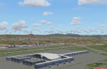
File Description:
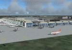
This is an update of my FS2004/FSX freeware scenery for EDDB, BER (former
Berlin Schoenefeld after its extension to Berlin Brandenburg Airport).
Changes:
- Updated threshold positions according to construction plans I got in 2011.
- Updated parking spot locations.
- Real taxiway and gate labels, including gate sizes for A380 and all taxiway signs.
- Updated layout of the terminal (south and north pier, which has been an option in 2006, are built now).
- Real ILS IDs and frequencies for the new runway I got from german ATC.
- New light spots.
Gernot Zander, 2006-08-07, 2011-09-20. Versions contained for both FS2004 and FSX.
| Filename: | EDDB_Berlin_Brandenburg_Airport_2011.zip |
| License: | Freeware |
| Added: | 20th September 2011, 22:51:27 |
| Downloads: | 4,010 |
| Author: | Gernot Zander |
| Size: | 4.9 MB |
© 2001-2026 AVSIM Online
All Rights Reserved
Privacy Policy |