
Where Flight Simulation Enthusiasts Gather from Around the World!
AVSIM Library - Search Results

| Category: Flight Simulator 2004 - Scenery | |
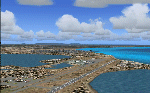
| Dawson Creek CYDQ in British Columbia, Canada |

|
Images related to this file:
File Description:
Dawson Creek is at 2,148 feet asl just east of the Rocky Mountains, less than 10 miles west of the BC/Alberta border. The Peace River, 25 miles north of Dawson Creek, links the two sides of the Rockies, winding through peaks that reach up almost to 8,000 feet. The population grew when the Northern Alberta Railway was extended to Dawsons Creek in 1932, and grew even more more when the Alaska Highway was built in 1942 and Dawsons Creek was where it started from. The airport is just to the east of the town. The runway is 5,000 feet of wide asphalt (150 feet) aligned 06/24, lit, and with PAPI and approach lights. There is a water runway to the north of the main runway with the same alignment, separately designated as Dawson Creek CBD3. The two operate as one; traffic for both use the mandatory frequency of 122.2 and talk to one controller in one control tower. However, in FS9 the ATC for two separately designated airfields operates as if they are nowhere near each other and near misses are the result. I have put them both in un-manned tower mode so you will announce your position and intentions and select your own parking spots etc. There is in reality a lack of apron markings but I have marked the positions of both gates. The apron is not large so there is only one other apron parking spot (see the traffic cone) and most parking is either next to one of the hangars or on the grass. The aprons vary from asphalt, to concrete, onwards to gravel, and then further onwards to some gravel amid the bare dirt; I have replicated this variation as far as FS9 permits. The buildings are bespoke from photos. The AI includes Central Mountain Air with two daily scheduled flights and Northern Cariboo as one of the airlines that occasionally runs charter flights in CYDQ. There are also private GA flights, and float plane flights into and out of CBD3.
| Filename: | Dawson_Creek_CYDQ_in_British_Columbia_Canada.zip |
| License: | Freeware, limited distribution |
| Added: | 22nd November 2013, 23:31:40 |
| Downloads: | 651 |
| Author: | Roger Wensley |
| Size: | 16.65 MB |
| Category: Flight Simulator 2004 - Scenery | |
| Farallon Island Chain, Version 4 |
|
File Description:
Beta version 4: Combines North, Middle, and Southeast Farallon Islands into one download. Lighthouse added to Southeast Farallon Island along with the water catchment pad (also serves as helipad). These islands were mysteriously absent from the FS2004 default scenery, probably owing to their small size. When I went to look for them I found a small mountain of water instead of the islands. Most people don't seem to be aware of the Farallon Islands. Located off the coast of California, near San Francisco, they are home to thousands of birds, seals, and some of the largest Great White sharks known to man. All of this is within a very short distance of the city. Today, it is a wildlife refuge and is off limits to visitation by the general public. Those of you interested in more info might check out "The Devil's Teeth" by Susan Casey. These islands were created as scenery objects instead of traditional terrain in order to preserve detail. The terrace on the Southeast Farallon Island is landable now but the terrain is pretty rough. If you're in Timberwolf Aviation and you're doing the multiplayer session on 03/26/2006, this is the version you should get.
| Filename: | Farallon_Island_Chain_Version_4.zip |
| License: | Freeware, limited distribution |
| Added: | 26th March 2006, 21:32:24 |
| Downloads: | 1,834 |
| Author: | Glen Gordon (Prof K.) |
| Size: | 1.51 MB |
| Category: Flight Simulator 2004 - Scenery | |
| Kangiqsualujjuaq CYLU in northern Quebec, Canada |
|
Images related to this file:
File Description:
Kangiqsualujjuaq is in northern Quebec on the east side of Ungava Bay, which is to the east of Hudson Bay and around 150 miles wide and 120 miles deep. Kuujjuaq, the administrative capital of northern Quebec, is 100 miles to the southwest. The town is on the bank of the George River, and has also been known as Fort George River, George River, etc. There was a Hudson Bay trading post at the town's location as early as 1838, though it was closed and reopened more than once and the town did not grow because of the trading post; the Inuit lived on the coast during the summer but moved 30 miles inland in winter for trapping. A cooperative was formed in 1959 to market fish, and this was the creative force that brought about establishment of the town; a school was built in 1963.
The airport is to the north of the town in a valley between the surrounding hills at 215 feet ASL. The gravel runway is just over 3,500 feet long and aligned 16/34; there is no PAPI, but there is fuel available, both 100LL and JetA. There are flights by Air Inuit and a warning of caribou on the runway during October and November.
| Filename: | Kangiqsualujjuaq_CYLU_in_northern_Quebec_Canada.zip |
| License: | Freeware, limited distribution |
| Added: | 1st February 2013, 21:24:55 |
| Downloads: | 277 |
| Author: | Roger Wensley |
| Size: | 2.76 MB |
| Category: Flight Simulator 2004 - Scenery | |
| Alpha Ventus Windpark |
|
File Description:
Alpha Ventus, Germanys first Ofshore-Windpark aprox. 45 Km north of the island of Borkum in the Northsea, consisting of 12 windturbines of 5 MW each. Went into operation on April 27. 2010 and was built at a cost of 250 million Euro, exceeding the initial estimate by 60 millions.
| Filename: | Alpha_Ventus_Windpark.zip |
| License: | Freeware |
| Added: | 2nd May 2010, 05:31:23 |
| Downloads: | 896 |
| Author: | Juergen Kuhnert |
| Size: | 19.38 KB |
| Category: Flight Simulator 2004 - Scenery | |
| Thompson Passm, Alaska K55 |
|
File Description:
Small grass airstrip scenery made with Lago's FS Enhancer for FS2004. All objects are within the air strip area so this should work on any terrain mesh. This is located in Alaska just north-east a fairly short flight from my other recent sceneries for Ellamar IZ9 and Tatitlek 7KA .
| Filename: | Thompson_Passm_Alaska_K55.zip |
| License: | Freeware |
| Added: | 7th July 2004, 23:49:48 |
| Downloads: | 980 |
| Author: | David King |
| Size: | 41.98 KB |
| Category: Flight Simulator 2004 - Scenery | |
| Small Brisbane Airports volume1 |
|
File Description:
Redcliffe YRED,Caboolture YCAB, Caloundra YCDR, Watts Bridge YWSG
These are four small GA and sport aviation airports all situated north of Brisbane, Queensland, Australia,and all an easy fly from each other. This scenery package requires the prior installation of Ross Caseys "Landclass, Roads, Coastline scenery for Queensland" scenery package.
| Filename: | Small_Brisbane_Airports__volume1.zip |
| License: | Freeware, limited distribution |
| Added: | 19th April 2004, 13:10:33 |
| Downloads: | 1,711 |
| Author: | Steve James |
| Size: | 7.4 MB |
| Category: Flight Simulator 2004 - Scenery | |
| Cyprus island |
|
Images related to this file:
File Description:
Cyprus is the Mediterranean more oriental island in Greek origin until the Turks occupied its north half after the second world war.
Eminently VFR and to be flown with slight airplanes to discover detail as their Turkish mosques in the northeast. I have distributed 112 cities among their two areas
| Filename: | Cyprus_island.zip |
| License: | Freeware |
| Added: | 12th September 2010, 18:15:45 |
| Downloads: | 4,634 |
| Author: | Toni Agramont |
| Size: | 36.52 MB |
| Category: Flight Simulator 2004 - Scenery | |
| Deline CYWJ - Northwest Territories, Canada |
|
Images related to this file:
File Description:
This is the third in a series of airfields that follow in a southward direction that early access route to the Canadian northern shore, the Mackenzie River. Deline is south of Tuktuk, Inuvik, Fort McPherson, and Fort Good Hope, all already posted. Deline is at 704 feet asl and around 50 miles east of the the Mackenzie, where the Great Bear River flows out of the western end of Great Bear Lake on its way to the Mackenzie. This lake is huge. The town of Deline has a population of around 500, and the first trading post (of the North West Company) was established there as early as 1799. The Hudson Bay Company opened an outpost in 1825 to support the Franklin Arctic Exploration expedition, and it was then called Fort Franklin. The name was changed to Deline in 1993. The airport is just over a mile north of the town, and has almost 4,000 feet of gravel runway. There is no fuel available. The original airfield is still visible just to the north of the town, from before it was rebuilt on higher ground (better drainage) and away from the houses. AI will follow with later posts.
| Filename: | Deline_CYWJ__Northwest_Territories_Canada.zip |
| License: | Freeware, limited distribution |
| Added: | 5th July 2014, 14:47:36 |
| Downloads: | 240 |
| Author: | Roger Wensley |
| Size: | 2.54 MB |
| Category: Flight Simulator 2004 - Scenery | |
| Attawapiskat CYAT in northern Ontario, Canada |
|
Images related to this file:
File Description:
Attawapiskat is on the north bank of the river of the same name, around 7 miles upstream from where the river meets the west shore of James Bay at its mid point. The top end of the Bay is around 140 miles north, Moosonee is around the same to the south, and the east shore 140 miles to the east. The town has a population of around 1,600, although this varies with the seasons as hunting and the traditional way of life on the land is still important to the Cree-speaking inhabitants. The airport is just to the north of the town with a gravel runway almost 3,500 feet long, and I have included the recently installed PAPI. The Canada Flight Supplement does not say anything about fuel being available so I presume the tanks beside the apron are no longer in use. There is also no apron lighting, unless it has been installed recently. There are flights by Air Creebec and by several other smaller airlines and I have included both Air Creebec and Wasaya; their textures are available for download and the planes are as listed in the AI folder.
| Filename: | Attawapiskat_CYAT_in_northern_Ontario_Canada.zip |
| License: | Freeware, limited distribution |
| Added: | 3rd January 2013, 01:37:50 |
| Downloads: | 376 |
| Author: | Roger Wensley |
| Size: | 3.54 MB |
| Category: Flight Simulator 2004 - Scenery | |
| Thailand Aircraft Carriers |
|
File Description:
This scenery will add 2 aircraft carriers off the coast of Thailand - one near Pattaya, and the other near Phuket. The model is based on Javier Fernandez's outstanding model, with slight modifications including animated radar, and Colin Thwaites' Fresnel Lens Optical Landing System (FLOLS). An AFD file is included for each, so you can select the carriers using the "goto airport" menu, and they will appear on your map and GPS. Navaids are also included to assist in locating the carriers (consult you map/GPS).
| Filename: | Thailand_Aircraft_Carriers.zip |
| License: | Freeware |
| Added: | 23rd January 2004, 01:05:31 |
| Downloads: | 6,842 |
| Author: | Martin Strong |
| Size: | 1.68 MB |
© 2001-2026 AVSIM Online
All Rights Reserved
Privacy Policy |