
Where Flight Simulation Enthusiasts Gather from Around the World!
AVSIM Library - Search Results

| Category: Flight Simulator 2004 - Scenery | |
| Hawaii V.2 Soaring Scenery |

|
File Description:
FS2002/2004 Hawaii V.2 Soaring Scenery
This file adds thermals lifts to flights over Hawaii Archipelago Region ,North America.
It is useful to glider´s flights betwen Kauai,Molokai,Oahu,Maui and Hawaii Islands.
It is freeware.
Good Flights and better Landings
Volta Redonda,Brazil,204/04/2006
| Filename: | Hawaii_V2_Soaring_Scenery.zip |
| License: | Freeware |
| Added: | 20th April 2006, 23:17:04 |
| Downloads: | 777 |
| Author: | Francisco Augusto Vargas Carneiro |
| Size: | 900.09 KB |
| Category: Flight Simulator 2004 - Scenery | |
| Miri Airport, Sarawak, East Malaysia |
|
File Description:
The newest Miri Airport completed construction in August 2003 in time for the then Prime Minister of Malaysia, Dr. Mahatir to open cermony before he stepped down.
The new Airport has extented runway of 8000ft.
Miri is a town located on North East of Sarawak, East Malaysia (Borneo island)
| Filename: | Miri_Airport_Sarawak_East_Malaysia.zip |
| License: | Freeware |
| Added: | 2nd April 2004, 15:41:54 |
| Downloads: | 2,896 |
| Author: | SK Yek |
| Size: | 1.57 MB |
| Category: Flight Simulator 2004 - Scenery | |
| Hadera 'Orot-Rabin' Power-Plant V2 |
|
File Description:
FS2004 Scenery - Orot-Rabin power plant near Hadera,
Israel (named after the late Israeli prime minister) is located
on the Mediterranean coast between Tel-Aviv and Haifa and
therefore is a well known landmark for VFR pilots. The
power plant is operated with coal and has an output of two
700mw + one 1,400mw turbines. A total of 2,800mw and
a 1,800 meter long unloading pier for coal ships. Made in
gmx. Enhanched with smoke effects and night lighting
for navigation.
| Filename: | Hadera_OrotRabin_PowerPlant_V2.zip |
| License: | Freeware |
| Added: | 18th November 2003, 16:55:19 |
| Downloads: | 6,785 |
| Author: | Seev Kahn |
| Size: | 687.86 KB |
| Category: Flight Simulator 2004 - Scenery | |
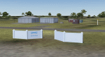
| "KAHANA" Rescue Ship Scenery Package |
|
File Description:
This is the scenery package that places the "KAHANA" Rescue ship (seen in TV-series LOST) near the coastline of PHJR. This ship is NOT drivable - it's a static object with a landable platform. The KAHANA really exists. I could not find an exact model to do this job. So I made this paint on Brian Smith's Coast Guard Ship. YOu can now exercise helicopter transfer flights from PHJR to the ship. This one is for als LOST Fans out there. Happy landings.
| Filename: | KAHANA_Rescue_Ship_Scenery_Package.zip |
| License: | Freeware |
| Added: | 11th April 2009, 19:49:08 |
| Downloads: | 767 |
| Author: | Brian Smith Joerg Zeitschel |
| Size: | 1.26 MB |
| Category: Flight Simulator 2004 - Scenery | |
| Doha, Qatar - Photoreal and Autogen |
|
Images related to this file:
File Description:
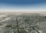
Doha is the capital city of the state of Qatar. Located on the coast of the Persian Gulf, it had a population of 998,651 and is also one of the municipalities of Qatar. The scenery covers the whole city of Doha and the surroundings, with the new airport under construction and "The Pearl", an artificial island built in the bay of Doha which is involved in a huge residential development. The autogen, with buildings, skyscrapers and vegetation, is included in the scenery.
| Filename: | Doha_Qatar___Photoreal_and_Autogen.zip |
| License: | Freeware |
| Added: | 4th June 2013, 21:49:11 |
| Downloads: | 4,162 |
| Author: | Luca Esposito, Fabio Ferrari |
| Size: | 76.26 MB |
| Category: Flight Simulator 2004 - Scenery | |
| FQVL - Vilankulo International Airport - Inhambane, Mozambique |
|
Images related to this file:
File Description:

A Gmax representation of Vilankulo International Airport (FQVL), Inhambane Province, Mozambique with photoreal textures.
Vilankulo is the gateway to the Bazaruto Archipelago, which consist of 6 islands just off the coast in the Indian Ocean. The airport also serves as the base from which flights to these islands originate. A separate package for the islands is available. Search for "mozarchi.zip".
The airport consist of a new modern terminal building and two runways, an NDB and night lighting.
| Filename: | FQVL__Vilankulo_International_Airport__Inhambane_M.zip |
| License: | Freeware, limited distribution |
| Added: | 20th November 2015, 16:22:50 |
| Downloads: | 496 |
| Author: | Kobus van Wyk, Aeroworx |
| Size: | 4.58 MB |
| Category: Flight Simulator 2004 - Scenery | |
| Pearly Beach Airfield, South Africa |
|
Images related to this file:
File Description:
A Gmax representation of Pearly Beach Airfield, Western Cape, South Africa with photoreal textures. Pearly Beach airfield is a small privately owned airfield between the towns of Pearly Beach and Gansbaai in South Africa. Bearly Beach and Gansbaai are both very well known tourist spots for whale watching and even shark-cage diving with Great Whites which are regularly seen just of the coast. The runway is aligned 30/12 and measures 838m x 9m. Even the animated windpump is included.
| Filename: | Pearly_Beach_Airfield_South_Africa.zip |
| License: | Freeware, limited distribution |
| Added: | 24th February 2017, 19:46:06 |
| Downloads: | 243 |
| Author: | Kobus van Wyk, Aeroworx |
| Size: | 1.55 MB |
| Category: Flight Simulator 2004 - Scenery | |
| PHJH Kapalua-West Maui |
|
Images related to this file:
File Description:

Kapalua airport (ICAO: PHJH—IATA: JHM—FAA:JHM) is located on the west side of the Hawaiian island of Maui. It serves Lahaina, and the resort communities of Kaanapali, Napili-Honokowai and Kapalua. This scenery includes a detailed model of Kapalua airport, the rooftop Hyatt Regency Resort helipad, approximately 170 square kilometers of West Maui terrain including extensive autogen buildings and trees, as well as numerous models of real-world resorts and hotels on a 12 km strip along the coast of West Maui.
| Filename: | PHJH_KapaluaWest_Maui.zip |
| License: | Freeware, limited distribution |
| Added: | 30th August 2017, 17:21:57 |
| Downloads: | 1,567 |
| Author: | Gregory Putz |
| Size: | 54.76 MB |
| Category: Flight Simulator 2004 - Scenery | |
| Lucky Lake CKQ5 in Saskatchewan, Canada |
|
Images related to this file:
File Description:
The village of Lucky Lake is 80 miles south of Saskatoon, with a small population of less than 300, most of whom are dependant on agriculture for income, either directly or indirectly. Marijuana is a recently introduced crop after the failure of a government-financed potato growing operation called SPUDCO. The village was previously known as Devil's Lake (don't ask me, I don't know). The airfield is half a mile north of the village, with an asphalt runway just over 3,000 feet long, lit, and aligned 07-25 in FS9; this has now changed to 08-26 with the wandering magnetic north. Circuits on 25 are right handed to avoid over-flying the village. 100LL fuel is available.
| Filename: | Lucky_Lake_CKQ5_in_Saskatchewan_Canada.zip |
| License: | Freeware, limited distribution |
| Added: | 25th May 2017, 17:53:36 |
| Downloads: | 138 |
| Author: | Roger Wensley |
| Size: | 5.36 MB |
| Category: Flight Simulator 2004 - Scenery | |
| Southern Ontario Canada LOD 9 Mesh |
|
File Description:
Please note that I forgot to cut the one side of the screenshots so the right side of the image is what was present on my second monitor which in the first two pictures was my background.
The default mesh for Southern Ontario Canada was pretty flat and did not show the small rolling hills that are present throughout the province. This is LOD9 (90 meter) mesh that covers ALL of Southern Ontario from Elliot Lake, Sudbury and North Bay in the North, to near Montreal in the east, to Windsor in the southwest and all points in between. This mesh covers the entire area of Ontario shown in the Toronto VNC.
| Filename: | Southern_Ontario_Canada_LOD_9_Mesh.zip |
| License: | Freeware, limited distribution |
| Added: | 16th January 2004, 02:01:29 |
| Downloads: | 6,542 |
| Author: | David Voogd |
| Size: | 41.32 MB |
© 2001-2026 AVSIM Online
All Rights Reserved
Privacy Policy |