
Where Flight Simulation Enthusiasts Gather from Around the World!
AVSIM Library - Search Results

| Category: Flight Simulator 2004 - Scenery | |
| Small Islands of Italy part 2, North-West, Photo Real |

|
Images related to this file:
File Description:
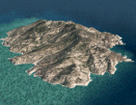
The photoreal scenery contains all the smalls islands of the North-occidental portion of Italy:
-Tuscan Archipelago (Elba, Giglio, Capraia, Pianosa, Montecristo, Gorgona, Giannutri); -Gallinara; -Asinara; -Maddalena; -San Pietro; -Santantioco; -Tavolara and Molara; -really small Islands next to Sardinia (Maldiventre, Cavoli, Serpentara, Bisce, Ogliastra etc.).
Every island has the seasonal variations, night textures and autogen. The remaining Italian islands are found on the file 'Italy_islands_VFR_part1_SE.zip' (available at AVSIM).
| Filename: | Small_Islands_of_Italy_part_2_NorthWest_Photo_Real.zip |
| License: | Freeware |
| Added: | 1st June 2010, 20:49:34 |
| Downloads: | 16,811 |
| Author: | Fulvio Mazzokan |
| Size: | 83.43 MB |
| Category: Flight Simulator 2004 - Scenery | |
| Thailand Aircraft Carriers |
|
File Description:
This scenery will add 2 aircraft carriers off the coast of Thailand - one near Pattaya, and the other near Phuket. The model is based on Javier Fernandez's outstanding model, with slight modifications including animated radar, and Colin Thwaites' Fresnel Lens Optical Landing System (FLOLS). An AFD file is included for each, so you can select the carriers using the "goto airport" menu, and they will appear on your map and GPS. Navaids are also included to assist in locating the carriers (consult you map/GPS).
| Filename: | Thailand_Aircraft_Carriers.zip |
| License: | Freeware |
| Added: | 23rd January 2004, 01:05:31 |
| Downloads: | 6,842 |
| Author: | Martin Strong |
| Size: | 1.68 MB |
| Category: Flight Simulator 2004 - Scenery | |
| Pulau Tioman Short Take-Off and Landing Airports (WMBT) |
|
File Description:
Tioman Island is a small island, 39 km long and 12 km wide, located off the east coast of Peninsular Malaysia. The densely forested island is still sparsely inhabited, but is surrounded by numerous white coral, making it
a haven for scuba divers from around the region. In the 1970s Time magazine selected Tioman as one of the world’s most beautiful islands.The island is served by ferries from the Malaysian mainland and Singapore, and propeller plane service by Berjaya Air from Singapore and Kuala Lumpur.
| Filename: | Pulau_Tioman_Short_TakeOff_and_Landing_Airports_WM.zip |
| License: | Freeware |
| Added: | 5th October 2005, 14:51:12 |
| Downloads: | 4,358 |
| Author: | Mohammad Ibrahim Rahmat |
| Size: | 4.71 MB |
| Category: Flight Simulator 2004 - Scenery | |
| Paulatuk CYPC in the Northwest Territories, Canada |
|
Images related to this file:
File Description:
Paulatuk is on the coast of northern mainland Canada, 200 miles east of Tuktoyaktuk and 170 miles southwest of Ulukhaktok. It is just to the east of the Parry Peninsula, which has at its northern tip the Cape Parry DEW line Main Station. Paulatuk was established in the 1920's, and the population now numbers around 320. Paulatuk airfield is close to the village but on higher ground, while the village follows the curve of the coast. The 4,000 feet of 100 feet wide gravel runway is aligned 021T/201T where T stands for "true" as opposed to magnetic in the Northern Domestic Airspace. Only JETA-1 is available unless there is 100LL in drums. There are flights by Aklak Air from Inuvik, which is around 250 miles to the west; Aklak Air is actually Kenn Borek under a diferent name. The AI is for a daily passenger flight, and for a cargo flight on Wednesdays. In the summer, float planes use the lake to the south of the village, but I have no information as to docks or any other facilities; probably there aren't any.
| Filename: | Paulatuk_CYPC_in_the_Northwest_Territories_Canada.zip |
| License: | Freeware, limited distribution |
| Added: | 3rd December 2012, 21:58:47 |
| Downloads: | 277 |
| Author: | Roger Wensley |
| Size: | 4.39 MB |
| Category: Flight Simulator 2004 - Scenery | |
| Geneer AKR Stations A thru G v3.0 |
|
Images related to this file:
File Description:

Version 3.0! Seven fictional seaplane bases with helicopter support (three new from v2.0) located south of Juneau, Alaska. Scenery completely redesigned in Gmax for compatible use with Glacier Bay v2, Tongas Fjords, and Misty Fjords by Holger Sandman. All but one spot included one or more helipads, and are intended for cargo distribution and supplies, these seven AKR Stations were also intended to serve as tourism spots for hunting, fishing, skiing, camping, etc. Just fun little spots to hop in a floatplane. No AI traffic in this version, however afcads do accommodate for ai traffic.
All Objects fully designed and completely redone using higher resolution 32bit textures. Optional DXT textures included. Also includes new AFCAD files, animated hangar doors. No AI traffic tracks included with this release, but AFCAD designed to support AI. This v3.0 package is a Full Install (w/ effect file).
| Filename: | Geneer_AKR_Stations_A_thru_G_v30.zip |
| License: | Freeware, limited distribution |
| Added: | 15th June 2010, 22:28:01 |
| Downloads: | 815 |
| Author: | EdGeneer Cox |
| Size: | 45.66 MB |
| Category: Flight Simulator 2004 - Scenery | |
| PABR - Barrow - Alaska, USA |
|
Images related to this file:
File Description:
The town of Barrow is in the far north of Alaska, and is best known in flying circles as the place where Wiley Post crashed his floatplane on takeoff and killed himself and Will Rogers. The crash was some 15 miles south of Barrow and was "assisted" by the mismatched fuselage, wings, and floats that had been assembled to create the floatplane. The Barrow population is largely Inupiat and totals some 4,400. The downtown area of Barrow is immediately north of the airport. The second and largest part of Barrow is further north past a string of lagoons and is locally called Browerville. To the northeast along the coast is the smallest part around what used to be the Naval Arctic Research Lab, and is now a college. To the east of this are the DEW buildings, plus two large navy hangars and the gravel runway that was used to serve the DEW station. The PABR runway is aligned 06-24 in FS9 and is 7,100 feet long and 150 feet wide, built on top of a gravel base and surround that copes with the underlying permafrost. There is PAPI at both ends and an ILS and approach lights on 06; 06 circuits are to the right. The airport notes include a warning that the apron is not a standard width and that large planes that are enroute to the far end of the runway will not be able to taxi past a plane parked at the gate and should use the runway as a taxiway, then turn and takeoff. FS9 AI cannot cope with that, so the apron here is wider. There are, in real life and the AI, daily flights by Air Alaska (three at least) and Era (several, and which is now called Ravn, hence the new hangar door motif) and air cargo flights by Northern Air Cargo and Everts, plus GA. The buildings have been made with photographic textures or textures made from reference photos. I decided that while 500+ scenery objects was probably ok for most people the required 900+ to "make" the town of Barrow would likely not be. The auto-generated FS9 town objects could not be left as Barrow with trees would not look at all like reality; I have "faded" the density of the town buildings into the distance from the airport.
| Filename: | PABR__Barrow__Alaska_USA.zip |
| License: | Freeware, limited distribution |
| Added: | 17th May 2016, 09:32:36 |
| Downloads: | 971 |
| Author: | Roger Wensley |
| Size: | 15.12 MB |
| Category: Flight Simulator 2004 - Scenery | |
| Steamboat Springs (KSBS), Flat Tops Wilderness Area, Colorado - Photo-Scenery |
|
Images related to this file:
File Description:

Steamboat Springs (KSBS), Flat Tops Wilderness Area, Colorado, Photo-Scenery (FS9 & FSX)
The Flat Tops Wilderness Area, which is the second largest wilderness area in Colorado, is named for its many flat topped mountains that are clearly visible from the sky. Trappers Lake, located in the north of the area inspired Arthur Carhart, a US Forest Service official, to initiate a plea for Wilderness preservation as early as 1919. Finally in 1975, three years before his death in 1978, the Flat Tops were designated a wilderness area. No wonder he found the area so entrancing: Behind Trappers Lake loom majestic volcanic cliffs, and beyond them a vast subalpine terrain reluctantly yields to alpine tundra with an average elevation of about 10.000 feet. More than 100 lakes dot the country above and below numerous flat-topped cliffs. Steamboat Springs is an internationally known winter resort destination.
To explore the scenery depart from Steamboat Springs Airport (KSBS) or Yampa Valley Airport (KHDN) and head south. High resolution versions of this scenery for FS9 and FSX (much sharper, but larger and multiple downloads) are available at www.blueskyscenery.com/GNB_West2.html . The screenies are taken from the high-res versions, so expect this version to be slightly more blurry. Thanks to Joop Mak for providing custom AFCADs that correct airport layouts so that they align with the photo-textures! They are available at www.blueskyscenery.com/AFCADs.html . YourDonation@Work: Dedicated to James.
| Filename: | Steamboat_Springs_KSBS_Flat_Tops_Wilderness_Area_C.zip |
| License: | Freeware, limited distribution |
| Added: | 26th April 2010, 17:53:25 |
| Downloads: | 1,302 |
| Author: | Gottfried Razek - blueskyscenery.com |
| Size: | 91.57 MB |
| Category: Flight Simulator 2004 - Scenery | |
| Baudette International Airport and Seaplane Base (KBDE), Minnesota |
|
File Description:
Here's an airport and seaplane base about as far north as you can go in the lower 48 states and still be in the USA! Made with EZ-Scenery...Please see "readme" file for list of libraries needed to use this scenery...Aerial photos and airport diagrams included...For freeware use only!
| Filename: | Baudette_International_Airport_and_Seaplane_Base_K.zip |
| License: | Freeware |
| Added: | 18th January 2006, 06:49:17 |
| Downloads: | 792 |
| Author: | Steve Ziegler |
| Size: | 717.01 KB |
| Category: Flight Simulator 2004 - Scenery | |
| EPBP - Biala Podlaska Airport - Biala Podlaska, Poland |
|
File Description:
Biala Podlaska Airport (IATA: BXP, ICAO: EPBP) is a former military airport, located near the town of Biala Podlaska, in the north of Lublin Voivodship. It is under modernisation to serve as a cargo airport and, in the future, to probably also serve passenger services in this area completely deprived of airports.
| Filename: | EPBP__Biala_Podlaska_Airport__Biala_Podlaska_Polan.zip |
| License: | Freeware |
| Added: | 13th September 2013, 22:58:57 |
| Downloads: | 465 |
| Author: | Billy Guo |
| Size: | 402.94 KB |
| Category: Flight Simulator 2004 - Scenery | |
| San Diego VFR Scenery version 2 |
|
File Description:
Compatable only with Ultimate Terrain USA or possibly any scenery that uses realistic coastlines, this file adds many scenery objects to the San Diego, CA area, including the USS Midway, Petco Park, the round hangars on North Island NAS, ships and boats in the bay and lots more. Much improved over version 1.
| Filename: | San_Diego_VFR_Scenery_version_2.zip |
| License: | Freeware |
| Added: | 24th July 2006, 02:17:15 |
| Downloads: | 3,310 |
| Author: | Tim Merrell |
| Size: | 412.26 KB |
© 2001-2026 AVSIM Online
All Rights Reserved
Privacy Policy |