
Where Flight Simulation Enthusiasts Gather from Around the World!
AVSIM Library - Search Results

| Category: Flight Simulator 2004 - Scenery | |
| Himalayas LOD9 Base Mesh, Volume 5 - Hindu Kush and Pamir |

|
Images related to this file:
File Description:
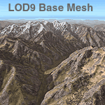
Detailed terrain mesh of the Hindu Kush and Pamir Ranges, N32-40 E70-76. The files in this package are based on Shuttle Radar (SRTM) Version 2 data but with many of the void areas, especially the most significant sections, filled with elevation data generated from topographic maps by Jonathan de Ferranti. While Jonathan's work is unrelated to flight simulation he kindly gave me permission to compile his data for use in FS. The result is a wonderful improvement in detail and accuracy over any existing mesh file, freeware or commercial, based on SRTM or DTED data alone.
Due to the large area of the Himalayas I've compiled the source data as two separate series: the "Himalayan Peaks" series covers prominent mountains and ranges in higher detail and locally overrides any existing LOD9 terrain mesh. In addition, the LOD9 "base mesh" series, with LOD8 and LOD7 "buffer" mesh files, covering the entire Himalayas, is meant for those who do not yet have an add-on terrain mesh of these beautiful mountains.
| Filename: | Himalayas_LOD9_Base_Mesh_Volume_5__Hindu_Kush_and_.zip |
| License: | Freeware, limited distribution |
| Added: | 29th May 2010, 08:57:29 |
| Downloads: | 7,607 |
| Author: | Holger Sandmann, Jonathan de Ferranti |
| Size: | 85.72 MB |
| Category: Flight Simulator 2004 - Scenery | |
| Himalayas LOD9 Base Mesh, Volume 4 - Kashmir and Jammu |
|
File Description:
Detailed terrain mesh of the Kashmir and Jammu Ranges, N30-39 E76-78. The files in this package are based on Shuttle Radar (SRTM) Version 2 data but with many of the void areas, especially the most significant sections, filled with elevation data generated from topographic maps by Jonathan de Ferranti. While Jonathan's work is unrelated to flight simulation he kindly gave me permission to compile his data for use in FS. The result is a wonderful improvement in detail and accuracy over any existing mesh file, freeware or commercial, based on SRTM or DTED data alone.
Due to the large area of the Himalayas I've compiled the source data as two separate series: the "Himalayan Peaks" series covers prominent mountains and ranges in higher detail and locally overrides any existing LOD9 terrain mesh. In addition, the LOD9 "base mesh" series, with LOD8 and LOD7 "buffer" mesh files, covering the entire Himalayas, is meant for those who do not yet have an add-on terrain mesh of these beautiful mountains.
| Filename: | Himalayas_LOD9_Base_Mesh_Volume_4__Kashmir_and_Jam.zip |
| License: | Freeware, limited distribution |
| Added: | 22nd February 2006, 20:32:50 |
| Downloads: | 7,505 |
| Author: | Holger Sandmann, Jonathan de Ferranti |
| Size: | 29.24 MB |
| Category: Flight Simulator 2004 - Scenery | |
| "Himalayan Peaks" LOD10 Mesh, Volume 8 - Tirich Mir and Pamir |
|
Images related to this file:
File Description:
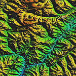
Highly detailed terrain mesh of the Tirich Mir and Pamir areas, N36-39 E71-74. The files in this package are based on Shuttle Radar (SRTM) Version 2 data but with many of the void areas, especially the most significant sections, filled with elevation data generated from topographic maps by Jonathan de Ferranti. While Jonathan's work is unrelated to flight simulation he kindly gave me permission to compile his data for use in FS. The result is a wonderful improvement in detail and accuracy over any existing mesh file, freeware or commercial, based on SRTM or DTED data alone.
Due to the large area of the Himalayas I've compiled the source data as two separate series: the "Himalayan Peaks" series covers prominent mountains and ranges in higher detail and locally overrides any existing LOD9 terrain mesh. In addition, a LOD9 "base mesh" series covering the entire Himalayas will be available for those who do not yet have an add-on terrain mesh of these beautiful mountains.
| Filename: | Himalayan_Peaks_LOD10_Mesh_Volume_8__Tirich_Mir_an.zip |
| License: | Freeware, limited distribution |
| Added: | 29th May 2010, 08:52:47 |
| Downloads: | 9,107 |
| Author: | Holger Sandmann, Jonathan de Ferranti |
| Size: | 47.94 MB |
| Category: Flight Simulator 2004 - Scenery | |
| Himalayas LOD9 Base Mesh, Volume 1 - Southeastern Ranges |
|
Images related to this file:
File Description:
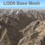
Detailed terrain mesh of the Southeastern Himalayan Ranges, N26-32 E90-98. The files in this package are based on Shuttle Radar (SRTM) Version 2 data but with many of the void areas, especially the most significant sections, filled with elevation data generated from topographic maps by Jonathan de Ferranti. While Jonathan's work is unrelated to flight simulation he kindly gave me permission to compile his data for use in FS. The result is a wonderful improvement in detail and accuracy over any existing mesh file, freeware or commercial, based on SRTM or DTED data alone.
Due to the large area of the Himalayas I've compiled the source data as two separate series: the "Himalayan Peaks" series covers prominent mountains and ranges in higher detail and locally overrides any existing LOD9 terrain mesh. In addition, a LOD9 "base mesh" series, with LOD8 and LOD7 "buffer" mesh files, covering the entire Himalayas, is meant for those who do not yet have an add-on terrain mesh of these beautiful mountains.
| Filename: | Himalayas_LOD9_Base_Mesh_Volume_1__Southeastern_Ra.zip |
| License: | Freeware, limited distribution |
| Added: | 29th May 2010, 09:01:26 |
| Downloads: | 10,301 |
| Author: | Holger Sandmann, Jonathan de Ferranti |
| Size: | 71.82 MB |
| Category: Flight Simulator 2004 - Scenery | |
| Himalayas LOD9 Base Mesh, Volume 2 - Southcentral Ranges |
|
Images related to this file:
File Description:
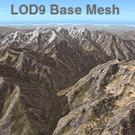
Detailed terrain mesh of the Southcentral Himalayan Ranges, N26-32 E82-90. The files in this package are based on Shuttle Radar (SRTM) Version 2 data but with many of the void areas, especially the most significant sections, filled with elevation data generated from topographic maps by Jonathan de Ferranti. While Jonathan's work is unrelated to flight simulation he kindly gave me permission to compile his data for use in FS. The result is a wonderful improvement in detail and accuracy over any existing mesh file, freeware or commercial, based on SRTM or DTED data alone.
Due to the large area of the Himalayas I've compiled the source data as two separate series: the "Himalayan Peaks" series covers prominent mountains and ranges in higher detail and locally overrides any existing LOD9 terrain mesh. In addition, a LOD9 "base mesh" series, with LOD8 and LOD7 "buffer" mesh files, covering the entire Himalayas, is meant for those who do not yet have an add-on terrain mesh of these beautiful mountains.
| Filename: | Himalayas_LOD9_Base_Mesh_Volume_2__Southcentral_Ra.zip |
| License: | Freeware, limited distribution |
| Added: | 29th May 2010, 09:05:56 |
| Downloads: | 9,451 |
| Author: | Holger Sandmann, Jonathan de Ferranti |
| Size: | 90.25 MB |
| Category: Flight Simulator 2004 - Scenery | |
| LGSR - Santorini Big Scenery - Santorini, Greece ** TEXTURE UPDATE ** |
|
Images related to this file:
File Description:
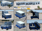
This FS2004 package is a free texture update for our previous greek "Santorini big scenery". The original project contain the "Santorini Thira Int. Airport" (Iata: JTR - Icao: LGSR)scenery and the "Santorini island" scenery (lanclasses, landmarks, autogen and more).
With this texture update (over 50 new files) you'll become new textures for some ground service veihcles (better quality and updated fuel companies), new textures for some airport buildings (updated to summer 2015, better resolution and quality), new "soft edge transition" on the apron textures, reduced texture size for the far away scenery objects (the result is a frame rate improvement) and other minor texture updates. This package contains textures only so the original "Santorini big scenery 2012" demo/free or full version is required.
Watch the screenshot and the demo video on the Albysim youtube chanel and check all scenery features reserved to the Premiun User (3D papi lights, 3D taxi lights, new vehicles, new autogen greek houses, new volumetric grass, new cablecar, other new details and objects).
| Filename: | LGSR__Santorini_Big_Scenery___Santorini_Greece___T.zip |
| License: | Freeware |
| Added: | 30th September 2015, 17:29:55 |
| Downloads: | 1,227 |
| Author: | Albysim Scenery Design |
| Size: | 17.63 MB |
| Category: Flight Simulator 2004 - Scenery | |
| Havenbrook Homes - Cork Airport |
|
File Description:
WARNING: File only works with LAGO FSE and Ron Silents FSE Add-on pack. Fictional Spotters housing near Cork Airport Ireland. Small village complete with Luxury bungalows, street lamps, trees, church, McDonalds, petrol station and Mall. Cork airport is on a plateau in FS so this uses the empty space at the end of runway 17 for some nice scenery on approach!
| Filename: | Havenbrook_Homes__Cork_Airport.zip |
| License: | Freeware |
| Added: | 27th December 2005, 01:01:29 |
| Downloads: | 409 |
| Author: | Graphix Paint Studio - René Bruun |
| Size: | 2.94 KB |
| Category: Flight Simulator 2004 - Scenery | |
| Vermont Airports 04 |
|
File Description:
Vermont Airport Multi-pack for Flight Sim 2004. Includes Burlington International (KBTV), Knapp State (KMPV), Morrisville-Stowe State (KMVL) and Warren Sugarbush Airport (0B7). Also included are custom AFCAD 2 files to allow AI traffic at airports that do not currently allow it, and sets parking in the proper places for Burlington. Requires Gerrish Greys's tree macros to be installed (trees_v3.zip)
| Filename: | Vermont_Airports_04.zip |
| License: | Freeware, limited distribution |
| Added: | 15th December 2003, 17:55:46 |
| Downloads: | 5,628 |
| Author: | Brian Gladden |
| Size: | 3.11 MB |
| Category: Flight Simulator 2004 - Scenery | |
| Paugan & Mercier Dams on the Gatineau River in Quebec Canada |
|
Images related to this file:
File Description:
This will not work without Ultimate Terrain, as the rivers and lakes just won't be there. The Paugan and Mercier Dams are on the Gatineau River in Quebec, north of Ottawa. Both of them are for power generation, rather than water conservation; the Paugan power generation building sits at the bottom of the sluiceway below the dam and appears far larger than the dam itself; there is a separate overflow sluice system nearby. The Paugan Dam is around 30 miles north up the river from Ottawa and the Mercier a further 70 miles. The Mercier holds back a huge and irregularly shaped volume of water known as the Reservoir Baskatong, with numerous branching arms and islands, and you will recognise where the dam must be long before you see it.
| Filename: | Paugan__Mercier_Dams_on_the_Gatineau_River_in_Queb.zip |
| License: | Freeware, limited distribution |
| Added: | 3rd May 2010, 00:11:21 |
| Downloads: | 273 |
| Author: | Roger Wensley |
| Size: | 421.81 KB |
| Category: Flight Simulator 2004 - Scenery | |
| Glacier Bay National Park, Alaska |
|
File Description:
Add-on meshes can greatly improve the detail of the FS terrain but often conflict with the inaccurate placement of the other default FS landscape elements, particularly in coastal and mountainous areas. This project showcases new methods and software that allow for semi-automated development of FS landscapes from accurate source data. The files completely replace the default FS landscape of Southeast Alaska's Glacier Bay National Park and the adjacent Lynn Canal area between Juneau and Skagway (N58-60 W134-138), including shorelines, islands, and lakes, as well as glaciers, landclass, man-made features, and a LOD9 (76-m) terrain mesh. Optional AI floatplane traffic at four seaplane bases is included. A LOD10 (38-m) mesh of the same area is available as a separate optional download. FS2002 users please use fs8glbay.zip instead.
| Filename: | Glacier_Bay_National_Park_Alaska.zip |
| License: | Freeware, limited distribution |
| Added: | 16th February 2004, 03:40:31 |
| Downloads: | 17,196 |
| Author: | Holger Sandmann, Jim Keir |
| Size: | 10.43 MB |


© 2001-2026 AVSIM Online
All Rights Reserved
Privacy Policy |