
Where Flight Simulation Enthusiasts Gather from Around the World!
AVSIM Library - Search Results

| Category: Flight Simulator 2004 - Scenery | |
| Bangkok Thailand VTBD |

|
File Description:
This scenery incorporates everything I have learned about scenery design. It is a major re-work of my previous scenery for Bangkok, which first came out over two years ago. Most airport buildings have been modeled and placed using numerous photographs and assistance from local sources, as well as the AIP for Thailand. I have also created a large part of the city, including major landmark buildings and several elevated helipads. The Chao Phraya River and many landmark parks and golf courses have been added using Ground2K. A custom AFCAD2 file is included. I have made extensive use of library objects and "LOD" models to keep the framerates reasonable, despite the higher detail compared with previous versions.
| Filename: | Bangkok_Thailand_VTBD.zip |
| License: | Freeware, limited distribution |
| Added: | 29th November 2003, 11:42:36 |
| Downloads: | 30,585 |
| Author: | Martin Strong |
| Size: | 8.59 MB |
| Category: Flight Simulator 2004 - Scenery | |
| Alaska/BC Bush Scenery: Edgecombe Lodge, Johnny Mountain Mine, & Bob Quinn Lake |
|
File Description:
My fourth bush scenery in Alaska/British Columbia. This package includes three airstrips: the first runway at Edgecombe Lodge has an unusual inclined profile, located precariously across a ridgeline on Annette Island near Ketchikan. I've also put together a tailor-made NDB Instrument Approach plate for it. The other two, Johnny Mountain Mine and Bob Quinn Lake, are hazardous real-life airstrips along the Iskut River in BC (about 50 miles north of Ketchikan). Includes AFCAD files for FS2004 and FS2002. Although I have modified the terrain to create the runways, Eddie Denney's FS2002 mesh of Alaska is still required as a foundation for this scenery to work. Also requires Gerrish Gray's Tree Library (release 3).
| Filename: | AlaskaBC_Bush_Scenery_Edgecombe_Lodge_Johnny_Mount.zip |
| License: | Freeware, limited distribution |
| Added: | 26th January 2004, 15:42:49 |
| Downloads: | 4,432 |
| Author: | James Belk |
| Size: | 5.64 MB |
| Category: Flight Simulator 2004 - Scenery | |
| CYVQ - Norman Wells - Northwest Territories, Canada |
|
Images related to this file:
File Description:
Norman Wells is the last of a series of airfields that are along (or close to) the Mackenzie River and in the Northwest Territories. It is 290 miles southeast of Inuvik and just 40 miles northwest of Tulita. The town growth was accelerated by the discovery of oil in the 1930's and the building of a small refinery in 1937, which is included here; there are now around 840 folks living in the town. The airport is adjacent to the town and has just under 6,000 feet of asphalt runway. North Wright Airways is headquartered there and this is reflected in the AI, which is for all of the newly-posted Mackenzie River postings. There is also helicopter AI, Canadian North, First Air, and there are GA flights. There is a mandatory frequency and the Norman Wells tower is manned 24 hours a day so you will follow atc instructions. In real life the terminal is on two levels; this steep change in terrain level is not possible to achieve in FS9 so although I made it as a two level terminal (ready for the FSX version?) it is here modified into a single level building. There are several "taxiways" which lead to the runway but are without hold short markings. These have been shown but are not included as AI routes. The helicopters presumably hover-taxi to the runway across grass (and snow) in real life; the AI helicopter will taxi on wheels. Note that at mixed-use airports planes and helicopters all follow the same rules of procedure.
| Filename: | CYVQ__Norman_Wells__Northwest_Territories_Canada.zip |
| License: | Freeware, limited distribution |
| Added: | 12th July 2014, 11:22:10 |
| Downloads: | 472 |
| Author: | Roger Wensley |
| Size: | 14.57 MB |
| Category: Flight Simulator 2004 - Scenery | |
| Rockcliffe Flying Club modifications for the Flight Ontario Rockcliffe CYRO scenery in Ontario, Canada |
|
Images related to this file:
File Description:
Flight Ontario posted their scenery for Rockcliffe CYRO in 2008, having worked with all the information they had but not all the information they would have liked (the usual situation with all scenery designers, including me). I learnt to fly at RFC and know Rockcliffe well so there are some additions and modifications here including the refueling point near the RFC buildings, revised apron shape, gravel car park, parked cars, extended perimeter fence, deck in front of the RFC clubhouse, more parked planes, the large and old willow tree, and the float dock in the river. Of course, since then the willow tree was felled by a tornado and there are now other major modifications including a new hangar, so watch this space.
| Filename: | Rockcliffe_Flying_Club_modifications_for_the_Fligh.zip |
| License: | Freeware, limited distribution |
| Added: | 7th February 2010, 13:55:27 |
| Downloads: | 443 |
| Author: | Roger Wensley |
| Size: | 1.17 MB |
| Category: Flight Simulator 2004 - Scenery | |
| Galena PAKP in Alaska |
|
Images related to this file:
File Description:
Galena is a village on the Yukon River, around 30 miles east of the corner where the westward running river turns south. The population is just under 500 and the city is noted for its educational facilities that attract residential students from across the state. Adjacent to the city is the Galena Air Force Station that previously shared the use of the Edward G. Pitna Snr. airport until 2007, when the station was closed and the air force personnel left. The station facilities have been taken over by the community and the airport became the largest state-maintained airport in the interior of Alaska. Substantial resurfacing and finishing work was then carried out, and the new asphalt runway is now 6,000 feet long and aligned 7-25, with VASI at both ends and ILS on 25. There is a secondary gravel runway beside part of the main asphalt runway, and this is treated in radio announcements as if it is not a separate runway and landing or take off are on the adjacent asphalt. The airport is serviced by ERA (now called Ravn) and Wrights Air, with cargo flights by the eternal Everts. Included here is a small modification for Allakaket, which deletes a single remaining stock FS9 taxiway light. The AI included here also provided Allakaket with a Saturday Everts delivery flight, but I neglected to mention that before. A note here about my scenery making. There will not be many more to follow this as I am almost at the end of the photos I either took or found for scenery purposes, plus I expect to move on from FS9 at some point during next year.
| Filename: | Galena_PAKP_in_Alaska.zip |
| License: | Freeware, limited distribution |
| Added: | 27th November 2019, 19:14:00 |
| Downloads: | 256 |
| Author: | Roger Wensley |
| Size: | 13.95 MB |
| Category: Flight Simulator 2004 - Scenery | |
| St Andre-Avellin CAA2 in Quebec Canada |
|
Images related to this file:
File Description:
St Andre-Avellin is a new airfield in Quebec Canada, 35 miles east of Ottawa and 10 miles north of the Ottawa River, and just northwest of the village of the same name. There is a 03/21 grass runway that is 2,870 feet long and slopes up towards the north. To show this slope I have not "placed" a grass runway (which would immediately flatten the slope) and anway there is not so much traffic that the grass would be notably marked. Because of the lack of an FS-recognised runway I have not made parking or a traffic file as AI would not work; anyway this airfield with constant activity would not reflect reality. There are no facilities at the airfield except a hangar for the owner and space to park.
| Filename: | St_AndreAvellin_CAA2_in_Quebec_Canada.zip |
| License: | Freeware, limited distribution |
| Added: | 9th April 2011, 20:49:47 |
| Downloads: | 168 |
| Author: | Roger Wensley |
| Size: | 816.9 KB |
| Category: Flight Simulator 2004 - Scenery | |
| Bettles PABT in Alaska |
|
Images related to this file:
File Description:
Bettles is around 175 miles north of Fairbanks in ALaska, and 25 miles north of the Arctic Circle. It is also where James "Andy" Andersen started flying for Wien Airlines and where he spent the 20 years between 1947 and 1967. Read "Arctic Bush Pilot" by Andy and Jim Rearden for his story of those 20 years flying the bush. Bettles PABT is the gravel strip and due to the limitations of FS9 AI the float base on the adjacent river has to be separately named PABX. Bettles village (old Bettles) used to be 2 miles southwest of the field, but has now slowly relocated close to the strip. In this download there is an AFCAD folder, landclass folders, a scenery folder, and a traffic folder. You will need Ultimate Terrain Alaska Canada.
| Filename: | Bettles_PABT_in_Alaska.zip |
| License: | Freeware, limited distribution |
| Added: | 22nd August 2010, 16:21:12 |
| Downloads: | 755 |
| Author: | Roger Wensley |
| Size: | 2.66 MB |
| Category: Flight Simulator 2004 - Scenery | |
| Perrine Bridge, Twin Falls Idaho Updated |
|
Images related to this file:
File Description:
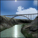
A prominent VFR landmark near Twin Falls Idaho, the Perrine Bridge spans over 1600' and stands 486 feet above the river below. At one time it was the tallest bridge in the world. Perrine Bridge is the only man-made structure in the USA were "base jumping" is allowed without a permit 365 days out of the year. Download includes gmax bridge object, a small photoscenery for the surrounding area, and two saved flight scenarios for exploring the scenery in the default J3 Cub. Bridge surface is landable and crash box has been removed allowing flight beneath the bridge. Scenery is compatible with, and nicely compliments John B. Loney's "Joslin-Magic Valley Regl" airport scenery (ktwf_v1.zip). Requires Ultimate Terrain and freeware mesh product, links provided in the readme.
| Filename: | Perrine_Bridge_Twin_Falls_Idaho_Updated.zip |
| License: | Freeware, limited distribution |
| Added: | 5th July 2011, 04:28:11 |
| Downloads: | 410 |
| Author: | Jim Robinson |
| Size: | 1.52 MB |
| Category: Flight Simulator 2004 - Scenery | |
| Frozen Canadian & USA Rivers & Lakes Revision |
|
Images related to this file:
File Description:
This "freezes" all lakes and rivers for winter flying and means they can be landed on with skis or wheels; it is meant for low level flying rather than high level jet flights. This edition is complete in itself and now really covers all of Canada and parts of the USA along the border, including large parts of Michigan, Wisconsin, Minnesota, North Dakota, and Montana. It is reversible with an "untick" in the FS scenery library. The revision is the addition of frozen sea in the area of Baffin Island (where I and Sid & Pete have recently posted all of the Baffin Island airfields) as I missed this area last time. Sorry about that. I have spent some time making sure that the sea and the inlets along the coast in the south do not get frozen too, and also some of the lakes that are close to the coast and rarely get cold enough to freeze over. The Great Lakes do not usually totally freeze, but this is an either ON or OFF modification and partial freezing cannot be convincingly simulated, so I went for total ice. Along the north shore I went for the peak of the winter with sea ice all the way to the permanent polar cap; this is not totally realistic as there is usually a partially open lead along the coast, but as with the Great Lakes...... It will work without Ultimate Terrain, but as UT is what gets all the lakes and rivers there and in the right place (except in the far north) it is obviously much improved with UT. The pics show Rockcliffe in the winter with the frozen Ottawa River for real and in FS for comparison; without UT the river would not be in the right place.
| Filename: | Frozen_Canadian__USA_Rivers__Lakes_Revision.zip |
| License: | Freeware, limited distribution |
| Added: | 6th September 2011, 00:42:43 |
| Downloads: | 622 |
| Author: | Roger Wensley |
| Size: | 1.2 MB |
| Category: Flight Simulator 2004 - Scenery | |
| Kuujjuarapik CYGW in northern Quebec, Canada |
|
Images related to this file:
File Description:
Kuujjuarapik is in northern Quebec at the southern end of Hudson Bay, 90 miles east of James Bay and on the north shore of the Great Whale River; Kuujjuarapik means Small Great River in Inuktitut. Once again the Hudson Bay trading post that opened (in 1820) was the catalyst for the establishment of first a seasonal encampment and then the beginnings of a town in the late 1930's.
The two adjacent villages that now form the town have a total population (mainly Cree and Inuit) of around 1,500. When the Quebec hydo-electric project was under construction in the early 1980's a large portion of the Inuit population voted to move to a new settlement called Umiujaq (my post) 100 miles to the north.
The airport is to the west of the town, between the town and the sea. The gravel and sand runway (which I have made as gravel as there is no convincing way to mix the two) is 5,500 feet long, 150 feet wide, and aligned 17/35, which is approximately parallel to the coast. There is fuel available, both 100LL and JetA, delivered by truck. The AI included here is for Air Inuit and Wasaya, with Air Inuit making three flights per day plus a fourth flight by the Air Inuit Twotter C-GNDO that is based at the airport, and private flights by various aircraft. Yes, there really is a golf course to the south of the airport, and the last thing to note is that Kuujjuarapik has a mandatory radio frequency and that taking into consideration the scheduled flights I have included the tower radio frequency that makes this a controlled airport in FS9.
| Filename: | Kuujjuarapik_CYGW_in_northern_Quebec_Canada.zip |
| License: | Freeware, limited distribution |
| Added: | 16th February 2013, 00:33:20 |
| Downloads: | 305 |
| Author: | Roger Wensley |
| Size: | 2.8 MB |
© 2001-2026 AVSIM Online
All Rights Reserved
Privacy Policy |