
Where Flight Simulation Enthusiasts Gather from Around the World!
AVSIM Library - Search Results

| Category: Flight Simulator 2004 - Scenery | |
| VFR of Lario, Area F1 - Como Lake, Italy |

|
Images related to this file:
File Description:

This 9th scenery covers approximately an area of 7.5x6 kmt, from Duria mountain (NW) to Sasso Canale mountain (NE), Brenzio's repeaters (SW) to Montecchio Nord and Adda river mouth (SE) and includes two NLC piers: Domaso and Gravedona; some of dedicated buildings are included, as Lusardi's Fort (Montecchio), St. Stefano and S. Miro churches, oratory, villa Giulini's ruins (Sorico), St. Bartolomeo church (Peledo), villa Camilla (Domaso), palazzo Gallio, St. Maria del Tiglio e St. Vincenzo churches (Gravedona) several camping areas, other minor boats and docks are placed alongside the lake coast.
Check video available here: http://youtu.be/g1EF6qjHutg
| Filename: | VFR_of_Lario_Area_F1__Como_Lake_Italy.zip |
| License: | Freeware |
| Added: | 24th December 2012, 17:23:46 |
| Downloads: | 968 |
| Author: | Aldo Della Vedova, Daniele Lanfranchi, Gian Mario Verga |
| Size: | 23.95 MB |
| Category: Flight Simulator 2004 - Scenery | |
| Parry Sound Harbour CPS1 in Ontario REPOST |
|
File Description:
This is a repost of yesterday's post of the Parry Sound Harbour as it seems one of the files didn't make it through the upload intact. Parry Sound Harbour float base is at the mouth of the Seguin River, where it flows into Parry Sound and Georgian Bay on Lake Huron, 110 miles north of Toronto. The base is run by Georgian Bay Airways Ltd who in 2006 were operating a Beaver and a Cessna 180, if I am remembering that right; the Beaver for sure. There is fuel and oil available, and food! This version has the modelled version of the float base building, after three years.
| Filename: | Parry_Sound_Harbour_CPS1_in_Ontario_REPOST.zip |
| License: | Freeware |
| Added: | 17th February 2009, 00:26:11 |
| Downloads: | 682 |
| Author: | Roger Wensley |
| Size: | 1.88 MB |
| Category: Flight Simulator 2004 - Scenery | |
| Mawlamyine Future-Airport VYMM |
|
File Description:
After opening of the Asian-Highway A1, that should lead from Viatnam up to Turkey, the Mawlamyine-Airport VYMM will increase in meaning drastically. Mawlamyine (Moulmein), the fourth-biggest city and former capital of Burma (Myanmar) lies only barely 80 km to the west of the Thai border and in the stretch-section Myawaddy-Thaton, with his construction was begun in the spring 2005. The bridge over the Thanlwin-River was already handed over to the traffic on February 05, 2005. On the new Airport big airplanes, like the B-744 and the A-388, can start and land. Installation in Deutsch and English. By HOUSE-RP, Switzerland
| Filename: | Mawlamyine_FutureAirport_VYMM.zip |
| License: | Freeware |
| Added: | 11th August 2005, 05:15:54 |
| Downloads: | 1,075 |
| Author: | HOUSE-RP, Robby Pauletto |
| Size: | 588.17 KB |
| Category: Flight Simulator 2004 - Scenery | |
| Groton-New London Sub Base |
|
File Description:
FS2004 Scenery - Naval Submarine Base New London Groton CT. On the east bank of the Thames River near Groton, CT, New London Naval Submarine Base was the birthplace of the submarine force. It was originally a Navy yard, converted to a submarine base in 1916, and greatly expanded in World War II. The advent of nuclear power required an improvement in training and support facilities. By 1959, New London had become the largest submarine base in the world with 8,210 active personnel. The base was recommended for closure by the DoD in the 2005 BRAC Recommendations. Created using Instant Scenery by John B. Loney, Jr.
| Filename: | GrotonNew_London_Sub_Base.zip |
| License: | Freeware, limited distribution |
| Added: | 31st March 2008, 03:07:08 |
| Downloads: | 1,040 |
| Author: | John B. Loney, Jr. |
| Size: | 3.79 MB |
| Category: Flight Simulator 2004 - Scenery | |
| VOCI Cochin International Airport - Kerala, India |
|
File Description:
This scenery pack contains Cochin Nebumbassery International airport, one of the busiest airport in Kerala, India for FS2004. May work in FSX and FS2002.
In the default the airport contains two simple basic building. This gives a real feel of the airport. This pack contains the following contents: domestic terminal and international terminal; completely modeled in gmax; lightpoles with effects; and realistic buildings. Big improvements for:
Aluva manappuram, Shiva temple; Landclass for the airport area, towns of Okkal thuruthu, Kalady, Kanjoor, Sreemoolanagaram, Thiruviranikkulam and Aluva; roads in front of the airport, corrected NH47, Kalady- Malayattoor road, Kalady- Aluva road and Kanjoor airport road; Missing parts of Periyaar river.
| Filename: | VOCI_Cochin_International_Airport__Kerala_India.zip |
| License: | Freeware, limited distribution |
| Added: | 22nd August 2011, 19:24:00 |
| Downloads: | 1,666 |
| Author: | Anstin Antony |
| Size: | 18.21 MB |
| Category: Flight Simulator 2004 - Scenery | |
| St. George (KSGU) / Mesquite (67L), Utah/Nevada, Photo-Scenery (FS9 & FSX) |
|
Images related to this file:
File Description:
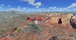
Covers the area between St. George, Utah and Mesquite, Nevada. To the north of St. George
the Pine Valley Mountains with their foothills of scenic red sandstone loom over the city.
St. George Municipal Airport (KSGU) is mostly used for general aviation but is also served by SkyWest Airlines
on behalf of Delta Connection. Because of it's location on a mesa this airport can't be expanded and so a new
airport is currently being built southeast of the city at the site of an abandoned airfield. The opening
is expected in 2011. To the south of the city make sure, you don't miss the Virgin River Gorge where the
Virgin River winds thru a long winding canyon in the transition zone between the red rocks of southern Utahs
Colorado Plateau and Nevadas Mojave Desert. Shortly afterwards you reach Mesquite which is situated just
west of the Arizona stateline. Like nearly all Nevada cities near the stateline Mesquite is home to several
Casinos. Mesquite Airport (67L) lies just north of the city.
High resolution versions of this scenery for FS9 and FSX (much sharper, but larger and multiple downloads)
are available at www.blueskyscenery.com/CNY_South3West6.html . The screenies are taken from the high-res versions,
so expect this version to be slightly more blurry. Thanks to Joop Mak for providing custom AFCADs that
correct airport layouts so that they align with the photo-textures! They are available at www.blueskyscenery.com/AFCADs.html .
YourDonation@Work: Dedicated to Werner, Ralf-Peter and Nels.
| Filename: | St_George_KSGU__Mesquite_67L_UtahNevada_PhotoScene.zip |
| License: | Freeware, limited distribution |
| Added: | 24th March 2010, 19:41:43 |
| Downloads: | 1,649 |
| Author: | Gottfried Razek - blueskyscenery.com |
| Size: | 95.58 MB |
| Category: Flight Simulator 2004 - Scenery | |
| Nanjing Dajiaochang Z08T - Chinese Airports From Yesteryear No.1 |
|
Images related to this file:
File Description:

Built with ADE with satellite aligning. Reqiures EZ scenery library: https://www.flightsim.com/files/file/143843-fs2004-ez-scenery-librarys-exe/.
This is the first airport in this series, focusing on old airports in China that now only lives in memory. Nanjing Dajiaochang Airport (NKG/Z08T) was an airport that served Nanjing, the capital of East China's Jiangsu province. It is located 6.2 kilometres (3.9 mi) south of Xinjiekou, the center of Nanjing, and is surrounded on three sides by the Qinhuai River. Opened in 1934, it was an important Chinese airbase during WWII. Civil aviation moved to the new Lukou International Airport in 1997, and then the airforce moved out in 2015 when Dajiaochang finally closed.
| Filename: | Nanjing_Dajiaochang_Z08T__Chinese_Airports_From_Ye.zip |
| License: | Freeware |
| Added: | 23rd July 2024, 00:59:47 |
| Downloads: | 45 |
| Author: | Yue Pan |
| Size: | 101.1 KB |
| Category: Flight Simulator 2004 - Scenery | |
| Mark Twain Lake, Hannibal, Mo. V3 |
|
File Description:
FS2004 Mark Twain Lake -- Hannibal, Mo. V3.
FS2004 scenery, From Bob's Hangar. An updated
version of my Mark Twain Lake Scenery for FS2004,
includes additions and new macros. New trees, built
in Terrian, no more flat shore lines. Natural bluffs.
Cannon Dam macro from EOD and actual digital photos.
Old downtown Hannibal Historic district, cobblestone
waterfront, restored boyhood home of Samuel Clemens,
(aka "Mark Twain"). Barge traffic on the Mississippi
River. Florida, Mo. with birthplace cabin of Mark Twain.
All shoreline attractions, and a typical farming and
ranching area of northeast Missouri. Includes three
upgraded default airports. Hannibal Municipal KHAE,
Wood Acres 7M01, and Samuel L. Clemens Memorial
MU00. This scenery works equally well in Fs2002.
By Robert Palmer
| Filename: | Mark_Twain_Lake_Hannibal_Mo_V3.zip |
| License: | Freeware, limited distribution |
| Added: | 25th June 2004, 14:16:07 |
| Downloads: | 1,664 |
| Author: | Robert Palmer |
| Size: | 5.96 MB |
| Category: Flight Simulator 2004 - Scenery | |
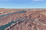
| Monument Valley, Kayenta (0V7), Utah/Arizona, Photo-Scenery |
|
Images related to this file:
File Description:

Monument Valley, Kayenta (0V7), Utah/Arizona, Photo-Scenery (FS9 & FSX)
This scenery covers the area from south of the San Juan River down to wonderful Monument Valley and Kayenta, AZ.
It extends my Lake Powell sceneries to the south and brings you another
3.500 sq km in 4.7m/pix quality. To explore the scenery depart from Kayenta (0V7) and head north.
High resolution versions of this scenery for FS9 and FSX (much sharper, but larger and multiple downloads) are available at www.blueskyscenery.com/CNY_South3West.html . The screenies are taken from the high-res versions, so expect this version to be slightly more blurry. YourDonation@Work: Dedicated to Thomas, Don and Eric.
| Filename: | Monument_Valley_Kayenta_0V7_UtahArizona_PhotoScene.zip |
| License: | Freeware, limited distribution |
| Added: | 23rd January 2010, 10:45:32 |
| Downloads: | 2,282 |
| Author: | Gottfried Razek - blueskyscenery.com |
| Size: | 93.49 MB |
| Category: Flight Simulator 2004 - Scenery | |
| Canyonlands National Park, The Maze-South, Utah, Photo-Scenery (FSX too) |
|
Images related to this file:
File Description:
This is a re-upload of a package that was corrupted during the crash of the AVSIM library. This is the fourth package of the Arches/Canyonlands area. It covers the area southwest and including the confluence of the Colorado and Green Rivers. From there you can fly down Cataract Canyon which is famed for its premium whitewater rafting oportunities. Or explore the Maze (the area west of the Green and north of the Colorado River) with it's labyrinth of canyons and colorful sandstone formations. The scenery extends west to Hite (UT03) on Lake Powell. Brings the total Southern Utah coverage to 14.000 sq km in 4.7m/pix quality. YourDonation@Work: Dedicated to Patrick, Hideyuki and Art. Thanks!
| Filename: | Canyonlands_National_Park_The_MazeSouth_Utah_Photo.zip |
| License: | Freeware, limited distribution |
| Added: | 31st December 2009, 22:33:46 |
| Downloads: | 2,080 |
| Author: | Gottfried Razek - blueskyscenery.com |
| Size: | 95.67 MB |
© 2001-2026 AVSIM Online
All Rights Reserved
Privacy Policy |