
Where Flight Simulation Enthusiasts Gather from Around the World!
AVSIM Library - Search Results

| Category: Flight Simulator 2004 - Scenery | |
| Knight Inlet CF36 float base in British Columbia, Canada |

|
Images related to this file:
File Description:
Knight Inlet is a floating lodge that organises "nature experiences", ranging from close encounters with local grizzly bears to fishing. Knight Inlet is to the north of "the narrows" where the Inside Passage gets squeezed between the mainland and Vancouver Island, and there is a chart section attached with a pointer to the location. At the bottom of the chart is Campbell River floatbase, and to the west is Port Hardy. Knight Inlet initially runs east-west, and the lodge is tucked into a smaller north-south offshoot, close to where the main inlet turns north. The water runway here is in the middle of the north-south offshoot, though of course in reality the "runway" is wherever the wind dictates it to be. The names highlighted in green on the chart are float bases to be renovated and posted with working AI. The buoyed log boom next to the lodge is to keep escaped logs from drifting in and colliding with boats; float plane pilots keep their eyes peeled too. Because of large hills adjacent to the lodge the landing of the AI may or may not take place, depending on wind direction and whether or not they fly into rock before landing. Take off and departure are far more reliable, particularly if the wind is from the south. Most of the AI is from Vancouver Harbour, Harbour Air Otters and West Coast Air Beavers, plus a SeAir Beaver from Campbell River and a private Cessna from the nearby Minstrel Island. This is the second in a series of new and renovated float bases in BC (the first being Sproat Lake) and to cope with the AI demands FSAddon have authorised the inclusion here of a bunch of AI Otters and Beavers that were originally part of a payware scenery for the area. Thanks are due there.
| Filename: | Knight_Inlet_CF36_float_base_in_British_Columbia_C.zip |
| License: | Freeware, limited distribution |
| Added: | 23rd December 2016, 08:16:24 |
| Downloads: | 218 |
| Author: | Roger Wensley |
| Size: | 16.95 MB |
| Category: Flight Simulator 2004 - Scenery | |
| FoxPine AirPark, New Zealand. NZFP. |
|
File Description:
Welcome to FoxPine Airpark ,NZFP.
FoxPine AirPark is situated by the small provincial town of Foxton on the South West coast of New Zealand’s North Island.
This Private Airfield set in park-like grounds is sited on a broad coastal plain of mixed farming and forestry bounded by sweeping beaches,
a meandering river, and off to the East, rugged bush-clad ranges, all great places to fly.
FoxPine is also where the "Jabiru" light aircraft is assembled, sold and serviced.
This scenery contains a bonus custom AI package, comprising of seven Jabiru-2's, a Cessna 172, and a Maule M6, and a traffic file for the aircraft. (AI Aircraft are complete with all files).
The AI aircraft, and the traffic file are fully compatible with GNZLAP traffic. Scenery requires some EZ Scenery Object Sets (see INSTALL instructions for details).
| Filename: | FoxPine_AirPark_New_Zealand__NZFP.zip |
| License: | Freeware, limited distribution |
| Added: | 14th August 2008, 21:27:16 |
| Downloads: | 927 |
| Author: | Lawrie Roache |
| Size: | 5.98 MB |
| Category: Flight Simulator 2004 - Scenery | |
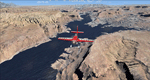
| Comb Ridge, Rock Point (49AZ), Utah/Arizona, Photo-Scenery |
|
Images related to this file:
File Description:

Comb Ridge, Rock Point (49AZ), Utah/Arizona, Photo-Scenery (FS9 & FSX)
This scenery extends my Monument Valley scenery to the east. It covers the area between the San Juan River in the north down to Rock Point, AZ (49AZ). Most of the scenery lies on the Navajo Nation Reservation. It completes the southeastern corner of Utah and paves our way into Colorado.
High resolution versions of this scenery for FS9 and FSX (much sharper, but larger and multiple downloads) are available at www.blueskyscenery.com/CNY_South3West6.html . The screenies are taken from the high-res versions, so expect this version to be slightly more blurry. Thanks to Joop Mak for providing custom AFCADs that correct airport layouts so that they align with the photo-textures! They are available at www.blueskyscenery.com/AFCADs.html . YourDonation@Work: Dedicated to Olivier, Kevin and Ruben.
| Filename: | Comb_Ridge_Rock_Point_49AZ_UtahArizona_PhotoScener.zip |
| License: | Freeware, limited distribution |
| Added: | 9th April 2010, 21:57:41 |
| Downloads: | 1,355 |
| Author: | Gottfried Razek, blueskyscenery.com |
| Size: | 90.99 MB |
| Category: Flight Simulator 2004 - Scenery | |
| Alaska North Slope 3: Atqasuk (PATQ) |
|
Images related to this file:
File Description:
The town of Barrow is in the far north of Alaska, and these are coastal villages or radar installations to the west and south of Barrow. There will be further additions. Atqasuk PATQ is 55 miles south of Barrow and is unusual in that it is one of the few settlements of the North Slope that is not on the coast. It is, however, on a narrow winding river that reaches the sea to the east of Barrow and seemingly provides fish in abundance. There could well be other good reasons for the village to be where it is, but they are unknown to me. The population is around 250. The airfield is to the south of the village and the runway is 4,900 feet of gravel aligned 06-24, lit, and with PAPI at each end.
| Filename: | Alaska_North_Slope_3_Atqasuk_PATQ.zip |
| License: | Freeware, limited distribution |
| Added: | 17th June 2016, 08:54:55 |
| Downloads: | 233 |
| Author: | Roger Wensley |
| Size: | 2.35 MB |
| Category: Flight Simulator 2004 - Scenery | |
| Fort Graham CBW3 in British Columbia Canada |
|
Images related to this file:
File Description:
Fort Graham is what looks like a very small village on the eastern shore of Williston Lake in northern British Columbia, around 100 miles north of Mackenzie (a previous post). The lake, while not large by Canadian standards, is well over 100 miles long but squeezed in width to a maximum of 5 miles amid the surrounding Rockies. The airfield has a gravel runway of 5,000 feet aligned 13-31 and at 2,230 feet ASL. There is no lighting. The operator of the airfield (and presumably the "village" too) is Finlay River Outfitters, a company that is based in Mackenzie and "outfits" hunting trips in the local area. I have posted this as Fort Graham CBW3, but I suggest that you just add it to your previously created "BC airfields" and avoid the inevitable doubling up of common textures etc. Up to you. If you find a defect, email me.
| Filename: | Fort_Graham_CBW3_in_British_Columbia_Canada.zip |
| License: | Freeware, limited distribution |
| Added: | 23rd November 2020, 20:13:11 |
| Downloads: | 105 |
| Author: | Roger Wensley |
| Size: | 7.75 MB |
| Category: Flight Simulator 2004 - Scenery | |
| Caballococha, Peru |
|
File Description:
Caballococha, Peru - Actually I have found only one photo of the town along the Amazon River and it was only of the Plaza. This is a total impressionistic file. Creates the town, riverside features (Piers, Ferry landing) and a few features to the default airport.
New AFCAD created offering parking and a taxiway, plus two water start locations. Again totally fictious. BUT enjoy.
One thing about Caballococha is that it is along a highly navagatable portion of the Amazon and with the fantastic array of Watercraft available offers, I believe, unlimited simming possibilities.
I included the .XML file for rwy12, if you are into enhancing your own scenery...please do feel free to modify or add as desired. This scenery DOES require both LAGO FSE (Payware) and RWY12 available here at avsim) to work.
questions or comments PLEASE do e-mail me ... I will respond as rapidly as possible.
[email protected]
| Filename: | Caballococha_Peru.zip |
| License: | Freeware |
| Added: | 9th April 2006, 04:19:26 |
| Downloads: | 714 |
| Author: | Dale Caruso |
| Size: | 225.37 KB |
| Category: Flight Simulator 2004 - Scenery | |
| Pontiac Airpark CPC7 in Quebec Canada |
|
Images related to this file:
File Description:
Pontiac Airpark is in Quebec on the north bank of the Ottawa River, some 20 miles northwest of Ottawa in Canada. It is a new airfield and in fact is still under construction, though the east-west runway has been in use since late last year. This east-west runway is 3,400 feet long and gravel, though it will later be lighted, and then asphalted. The second runway will be just under 2,000 feet and unlighted gravel, and at its southern end there are docks for float planes. The float base is already in use; CPC7 is the ICAO code for the float base. There are lots for sale, and the idea is to build your house right on the airfield so there is no driving necessary between house and plane, thus leaving more time for what is important. There will be updates as things progress.
| Filename: | Pontiac_Airpark_CPC7_in_Quebec_Canada.zip |
| License: | Freeware, limited distribution |
| Added: | 1st May 2010, 00:33:40 |
| Downloads: | 339 |
| Author: | Roger Wensley |
| Size: | 7.06 MB |
| Category: Flight Simulator 2004 - Scenery | |
| Lake Powell East / Natural Bridges National Monument, Utah, Photo-Scenery |
|
Images related to this file:
File Description:
Lake Powell East / Natural Bridges National Monument, Utah, Photo-Scenery (FS9 & FSX)
This scenery covers the eastern part of Lake Powell from just south of Hite (UT03) and goes down south along White Canyon, Natural Bridges National Monument and the Grand Gulch Primitive Area all the way to the San Juan River. It extends my Canyonlands sceneries to the south and brings you another 3.500 sq km of wonderful southern Utah in 4.7m/pix quality. To explore the scenery depart from Cal Black Memorial Apt. (U96) and head east. High resolution versions of this scenery for FS9 and FSX (much sharper, but larger and multiple downloads) are available at www.blueskyscenery.com/CNY_South2West.html. The screenies are taken from the high-res versions, so expect this version to be slightly more blurry. YourDonation@Work: Dedicated to Guy, Ruben and EDB.
| Filename: | Lake_Powell_East__Natural_Bridges_National_Monumen.zip |
| License: | Freeware, limited distribution |
| Added: | 4th January 2010, 19:19:43 |
| Downloads: | 1,870 |
| Author: | Gottfried Razek, blueskyscenery.com |
| Size: | 95.26 MB |
| Category: Flight Simulator 2004 - Scenery | |
| Revised East Vancouver Islands - compatible with vicenh05 |
|
File Description:
These files are a revision of the default Vancouver Island shorelines and landclass textures from Chemainus to Campbell River, British Columbia. Included are the islands from the Southern Gulf Islands to Texada Island and inland to Cowichan Lake. Most of the smaller lakes within 20 km of the shoreline have been redrawn as well. In this version shorelines have been revised to match Jon Patch & Holger Sandman's vicenh05.zip. As well major corrections for the shorelines in LOD5 area 117-114, Comox, have been made so that the shorelines now conform to the 38.2m mesh and to Vern Opperman's CFB - Comox version 042. Shoreline types are changed to look more like the Pacific Northwest courtesy of Holger Sandman's who made his shoreline textures for vicenh05 available. Also in this version no roads are included since complete British Columbia roads in bcroadsys.zip are now available.
| Filename: | Revised_East_Vancouver_Islands__compatible_with_vi.zip |
| License: | Freeware, limited distribution |
| Added: | 8th October 2005, 20:17:46 |
| Downloads: | 3,925 |
| Author: | Harvey Janszen |
| Size: | 346.85 KB |
| Category: Flight Simulator 2004 - Scenery | |
| Inuvik CYXT in the Northwest Territories, Canada |
|
Images related to this file:
File Description:
Inuvik is a town of 3,500 or so inhabitants at N68 18 W133 29, which puts it 120 miles inside the Arctic Circle on the east side of the Mackenzie River delta and around 90 miles from where the Mackenzie meets the Beaufort Sea. There is a Canadian Forces base at the eastern end of the field, with shelters for six F18 fighters; the base in one form or another has been there for a while and is the reason for the generous length of asphalt runway.
Inuvik was established in the early 1960's as a replacement regional center for Aklavik which is 40 miles to the west across the delta and which flooded on a regular and inconvenient basis. This probably works without Ultimate Terrain but I haven't tested it. I also haven't tested it in FSX but I was told it works there too.
| Filename: | Inuvik_CYXT_in_the_Northwest_Territories_Canada.zip |
| License: | Freeware, limited distribution |
| Added: | 6th October 2010, 13:22:04 |
| Downloads: | 942 |
| Author: | Roger Wensley |
| Size: | 4.12 MB |
© 2001-2026 AVSIM Online
All Rights Reserved
Privacy Policy |