
Where Flight Simulation Enthusiasts Gather from Around the World!
AVSIM Library - Search Results

| Category: Flight Simulator 2004 - Scenery | |
| RAF Bovingdon EGWX 1955 |

|
File Description:
Bovingdon was a London airport of some importance and used as an alternate by (at least) BOAC and Pan Am after the Second World War, partly because its elevation of just over 500 feet made it less subject to poor visibility than London Heathrow. It had been built for RAF four-engined bombers near the village of Bovingdon in Hertfordshire and was used by Bomber Command from June 1942 but transferred to the US Eighth Air Force in August. They only flew operational missions with B-17s for a brief period and after that it was employed for crew training until September 1944 when it became the base for the European Air Transport Service. It was returned to the RAF in 1947 but handed over for use by civilian airlines while retaining significant military roles. The RAF Fighter Command Communication Squadron was based there and in 1951 the USAF assigned the C-47s of the 7531st Air Base Squadron to it, though other USAF types visited in large numbers on a transitory but routine basis. The USAF left in October 1962 but the RAF remained there until the airfield was closed in 1972. This scenery recreates Bovingdon, with period traffic, as it was in 1955.
| Filename: | RAF_Bovingdon_EGWX_1955.zip |
| License: | Freeware |
| Added: | 18th February 2025, 15:28:48 |
| Downloads: | 95 |
| Author: | CalClassic, Ken Lawson, Al Von Pingel |
| Size: | 15.09 MB |
| Category: Flight Simulator 2004 - Scenery | |
| Kogd-Ogden,Utah |
|
Images related to this file:
File Description:
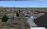
KOGD-Ogden,Ut Take your sailboat to the Great Salt Lake inland sea or hike the many mountains and enjoy the vistas offered atop the lofty peaks. Visit the quiet mountain valley town of Eden to the east of KOGD with its annual balloon festival and summer fun on Pineview dam or spend the day shopping the shops of Brigham City to the north or Salt Lake City to the south. Fly over the Great Salt Lake to the west. See the Ogden airport come alive with this must have add-on. With the help of Google Earth and FS Earth I have recreated the Ogden airport, with its new taxiway A (from a site visit), and the surrounding cities and towns to look as real as possible. Made with Ultimate Terrain, but the airport should be ok with default FS9. (No guarantee though ;-) The scenery enhancements were made with Ultimate Terrain in place. I modified the landclass to look more like the real thing. The airport is very close to a exact replica of KOGD! The crane by the tower was there when I took the pictures so I included it.
| Filename: | KogdOgdenUtah.zip |
| License: | Freeware |
| Added: | 15th December 2009, 00:45:07 |
| Downloads: | 725 |
| Author: | Alan C. Heiner |
| Size: | 15.59 MB |
| Category: Flight Simulator 2004 - Scenery | |
| Kogd-Ogden,Utah |
|
Images related to this file:
File Description:

KOGD-Ogden,Ut
Take your sailboat to the Great Salt Lake inland sea or hike the many mountains and enjoy the vistas offered atop the lofty peaks. Visit the quiet mountain valley town of Eden to the east of KOGD with its annual balloon festival and summer fun on Pineview dam or spend the day shopping the shops of Brigham City to the north or Salt Lake City to the south. Fly over the Great Salt Lake to the west.
See the Ogden airport come alive with this must have add-on. With the help of Google Earth and FS Earth I have recreated the Ogden airport, with its new taxiway A (from a site visit), and the surrounding cities and towns to look as real as possible.
Made with Ultimate Terrain, but the airport should be ok with default FS9. (No guarantee though ;-)
The scenery enhancements were made with Ultimate Terrain in place. I modified the landclass to look more like the real thing. The airport is very close to a exact replica of KOGD! The crane by the tower was there when I took the pictures so I included it.
| Filename: | KogdOgdenUtah.zip |
| License: | Freeware |
| Added: | 20th January 2009, 13:42:09 |
| Downloads: | 1,344 |
| Author: | Alan C. Heiner |
| Size: | 15.59 MB |
| Category: Flight Simulator 2004 - Scenery | |
| Kenmore Village Field CF08 near Ottawa in Ontario, Canada |
|
Images related to this file:
File Description:
Kenmore Village Field is in Ontario, at the northwest corner of the village of Kenmore. Kenmore is around 13 miles southeast of Ottawa airport and 3 miles east of Bank Farm Field. The village doesn't appear in FS as it is too small, but I have recreated it based on the roads that show in Ultimate Terrain. There is a grass runway 09/27 (actually 086/266) that is 3,100 feet long, and the grass is good, and with lights. The field is owned by a gentleman in his mid 70's who sold his plane five years ago and less than two years later discovered that he really didn't want to give up flying; he then went out and bought another slightly older and cheaper version of the one he sold. The house is in a direct line with the runway approach from the east; try to miss it. There is a large hangar and workshop behind the house and to the north of the runway center line, and a second older hangar on the same side a bit further along, both modeled specifically for this.
| Filename: | Kenmore_Village_Field_CF08_near_Ottawa_in_Ontario_.zip |
| License: | Freeware, limited distribution |
| Added: | 9th February 2010, 13:39:57 |
| Downloads: | 394 |
| Author: | Roger Wensley |
| Size: | 10.69 MB |
| Category: Flight Simulator 2004 - Scenery | |
| Indian Creek Farm Field CF07 near Ottawa in Ontario, Canada |
|
Images related to this file:
File Description:
Indian Creek farm field (Re-upload WITH THE MISSING TEXTURES!) is in Ontario and southeast of Ottawa, less than two miles east of two other real-life farm fields I have already posted (Russell Farm, and Russellette Strip). The creek is just north of the runway in the trees, though it doesn't show in FS with or without Ultimate Terrain.
There is a grass runway 08/26 that is 2,100 feet long and has lights; the grass could be better (I mean there could be more of it) but the drainage is good. There is a large hangar that is right by the house and is heated (wow!); this is for the owner. There are also eight other hangars which are slightly basic and without doors, which means boxes over the wheels so the tires don't get chewed by the wild life and canvas hangar fronts for the winter. All the hangar buildings are modeled specifically for this scenery. The runway has been there for 22 years, and before that (though with a large gap between) there was a military grass strip as a relief field for nearby Pendleton .
| Filename: | Indian_Creek_Farm_Field_CF07_near_Ottawa_in_Ontari.zip |
| License: | Freeware, limited distribution |
| Added: | 8th February 2010, 09:45:16 |
| Downloads: | 442 |
| Author: | Roger Wensley |
| Size: | 11.35 MB |
| Category: Flight Simulator 2004 - Scenery | |
| Alps LOD10 Topo Mesh - Switzerland and France |
|
Images related to this file:
File Description:
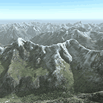
Yet another terrain mesh package of the European Alps? Well, this one is different in that it is NOT primarily based on the Shuttle Radar (SRTM) data with their incomplete coverage of prominent peaks and ridges. Instead, most of the source data for this project were developed over many months by Jonathan de Ferranti using detailed topographic maps. While Jonathan's work is unrelated to flight simulation he kindly gave me permission to compile his data for use in FS. The result is a wonderful improvement in detail and accuracy over any existing SRTM- or DTED-based mesh file, freeware or commercial (a link to an extensive set of screenshot comparisons is included in the read-me file).
I've compiled the source data at LOD10 (38-m) grid resolution because the coverage area is smaller than most existing mesh files. Thus, anyone can use these files without having to first uninstall their current mesh set. Also included are LOD9 and LO8 buffer mesh files. Note: if you own Switzerland Professional with its high-resolution terrain mesh then you don't need this package, at least not the Switzerland files!
| Filename: | Alps_LOD10_Topo_Mesh__Switzerland_and_France.zip |
| License: | Freeware, limited distribution |
| Added: | 30th May 2010, 09:51:03 |
| Downloads: | 58,986 |
| Author: | Holger Sandmann, Jonathan de Ferranti |
| Size: | 50.03 MB |
| Category: Flight Simulator 2004 - Scenery | |
| NZAA auckland airport for fs9/fs2004 |
|
File Description:
Auckland Airport[5] (IATA: AKL, ICAO: NZAA) is an international airport serving Auckland, the most populous city of New Zealand. It is the largest and busiest airport in the country, with over 16 million passengers served in the year ended August 2023.[6] The airport is located near Māngere, a residential suburb, and Airport Oaks, a service-hub suburb 21 kilometres (13 mi) south of the Auckland city centre. It serves as the principal hub for Air New Zealand and the New Zealand operating base for Jetstar.
Features of this scenery include:
1)Highly modeled terminals and buildings
2)roads and highways
3)surrounding warehouses
4)Custom ground poly LINES
5)lots of ground equipment
6)3d grass
7)trees----> have seasonal issues but will update once fixed
8)cars and fences
9)custom textures and night lighting
10)2 major hotels near the international terminal
11)Accurate taxiways and hangars
12) Localizer antennas
13)street lights
Please put these files in the addon scenery folder of your FS9 directory
And add in fs
They shouldn't cause any issues.
(http://www.mediafire.com/file/emh3ksaq3nd7igk/real_new_zealand_auckland_city.rar) link for the city.
| Filename: | NZAA_auckland_airport_for_fs9fs2004.zip |
| License: | Freeware |
| Added: | 26th April 2025, 14:00:30 |
| Downloads: | 352 |
| Author: | Jeremy Paul Joby |
| Size: | 91.51 MB |
| Category: Flight Simulator 2004 - Scenery | |
| VVCR Cam Ranh Airport |
|
Images related to this file:
File Description:

Cam Ranh is currently a fast-growing beauty spot and tourist area on the Vietnamese coast. In May 2004, Cam Ranh airport (VVCR) opened to commercial traffic, initially only serving domestic traffic but international flights will commence in 2005. The airport was once a massive US Air Force base, but was later used as a base for Russion spy plane activities.
This scenery adds this "missing" airport to Flight Simulator, but much is based around satellite views of the airport when the US were spying on the Russian base and other historical information and it may not accurately reflect the airport as it is today. Furthermore, my capabilities at scenery design are limited and restricted to scenery objects available through the Rwy12 scenery creation programme.
You do NOT need to download and install the full 45 MB Rwy 12 Object Placer programme, which is for the designers and not the end user.
Some of the scenery objects will appear without any extra downloads, but to get the greatest benefit from this scenery, you may optionally download following files, which should be installed according to the instructions within this download and not as described in their own download archive:
Level 2 objects
rwy12-lvl2.zip (Israel Roth and Seev Kahn/John Hinson),
Level 3 objects
jw_rwy12.zip (Shehryar Ansari),
tl_rwy12.zip (Todd Lucas) ,
ford_transit_collection.zip (S Legg),
hgrrwy12.zip (ESDG), and
ga-hangers_lib_for_rwy12.zip (S Legg)
Also included with this scenery are two EditVoicepack files which may be imported to that programme so that the controllers will be heard referring to "Cam Ranh".
[File re-uploaded at request of AVSIM] See also file vvcru11.zip.
| Filename: | VVCR_Cam_Ranh_Airport.zip |
| License: | Freeware |
| Added: | 15th May 2010, 01:13:46 |
| Downloads: | 4,168 |
| Author: | John Hinson |
| Size: | 21.36 KB |
| Category: Flight Simulator 2004 - Scenery | |
| RAF Chivenor 1979-1992 |
|
Images related to this file:
File Description:

Originally a civil airfield opened in the 1930s, the site was taken over by the Royal Air Force in May 1940 for use as a Coastal Command Station, and was known as RAF Chivenor. After the Second World War, the station was largely used for training, particularly weapons training. During the 1960s, one of the RAF's Tactical Weapons Units (TWU) used Hawker Hunter aircraft for training. In 1974 the station was left on "care and maintenance", though No. 624 Volunteer Gliding Squadron continued to fly from there. The TWU returned, flying BAE Hawks, in 1979 and 1981. In 1994, the TWU left Chivenor, merging with No. 4 Flying Training School at RAF Valley, and the airfield was handed over to the Royal Marines.
This scenery includes all the Hawk aircraft of 2 TWU in both camouflage and air defence grey schemes, depending on your preferred choice. There are flightplans included, which are representative only, but enables the aircraft to fly to bases and checkpoints around the country.
The scenery has been constructed using objects mainly from MAIW sceneries, which will need to be installed in order to gain the full visual experience. With BIG thanks to Nick Black for the use of his superb AI Hawk, and to Chris A. Brown for paintin' 'em!
| Filename: | RAF_Chivenor_19791992.zip |
| License: | Freeware, limited distribution |
| Added: | 21st June 2013, 21:28:56 |
| Downloads: | 1,173 |
| Author: | Brian Clarke, Stewart Pearson, Daryl Payne, Chris A. Brown |
| Size: | 22.67 MB |
| Category: Flight Simulator 2004 - Scenery | |
| Monterey Academy CA66 California Scenery |
|
File Description:
This is a scenery upgrade for Monterey Academy Airstrip, California (CA66). This is part Seven of a
series of small airstrip and minor airfield scenery enhancements which are based on real world data
from Google Earth.
Changes to default include an AFCAD file that covers some of the buildings that seem to be
associated with the airstrip, Landclass change to reflect the fact that the strip lies in agricultural
ground rather that the scrubland the default has it in. Note that the buildings are used to appear
the same as they do from directly above rather than a genuine representation of what is probably
there. So from ground level it will look a lot different to the real thing should you be familiar with it!
This is due to the limited number of buildings available ATM.
Also My screenshots are using Flight1 Ground Environment textures, so your land may look different
if you have the default terrain.
Thanks to Jon "Scruffyduck" Masterson for tutorials on LC and scenery design.
Built using EZ_Scenery, Lee Swordy's AFCAD and SBuilder. You must have rwy12 and EZ scenery
libraries installed for the buildings to show, both libraries of objects are free
EZ Library is available from this URL http://www.abacuspub.com/pub/AbacusEZLibraries.exe
rwy12 from Avsim and additional EZ Custom libraries from Avsim also, search under Scenery design.
| Filename: | Monterey_Academy_CA66_California_Scenery.zip |
| License: | Freeware |
| Added: | 25th March 2006, 23:10:11 |
| Downloads: | 589 |
| Author: | Kim Gowney |
| Size: | 250.98 KB |
© 2001-2026 AVSIM Online
All Rights Reserved
Privacy Policy |