
Where Flight Simulation Enthusiasts Gather from Around the World!
AVSIM Library - Search Results

| Category: Flight Simulator 2004 - Scenery | |
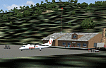
| Kindley Field Bermuda 1955-1962 |

|
File Description:
Kindley Field, on the British Overseas Territory of Bermuda, was built as a joint RAF/USAAF facility during the Second World War. Subsequently the RAF area became the civilian terminal while Kindley Air Force Base was operated by the USAF between 1948 and 1970. It was primarily a staging post between the US and Western Europe for land-based planes unable to cross the Atlantic non-stop, very like Ernest Harmon in Newfoundland and the civilian Gander, and like Harmon it closed when the jet age made such bases redundant. Prior to that it hosted no combat units, but the 59th and then 53rd Weather Reconnaissance Squadrons, the 'Hurricane Hunters', were based there, and also from 1 February 1956 to 15 June 1963 the 303rd ARS Stratotankers were present to support Strategic Air Command and other refueling requirements. After 1970 it became a US Navy facility primarily concerned with tracking Soviet submarines, and was closed at the end of the Cold War. This scenery represents Kindley between 1955 and 1962 and has custom made scenery by Dan French and ai military traffic by Al Von Pingel to add to the downloadable California Classic civilian and MATS traffic available at Tom Gibson's site. Like Harmon and Gander, it was one of the most important airfields of its time.
| Filename: | Kindley_Field_Bermuda_19551962.zip |
| License: | Freeware |
| Added: | 3rd December 2022, 13:10:38 |
| Downloads: | 145 |
| Author: | Ken Lawson, Al Von Pingel, Dan French |
| Size: | 30.31 MB |
| Category: Flight Simulator 2004 - Scenery | |
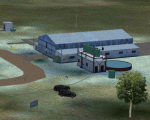
| WASF Fak-Fak |
|
Images related to this file:
File Description:
Googly scenery for WASF Fak-Fak, in Irian Jaya (Western New Gunea),
Indonesia - a small domestic airport that Microsoft managed to omit from Flight
Simulator 2004. These scenery files add the runway, apron, taxiways, buildings
and other airport features so that you and your "AI" traffic can land, taxi,
park and take off in a realistic manner.
Little information is available on the services operated - flight plans are
available for Lion Airlines showing two flights per week operated on their behalf
by Wings Abadi Dash 8 aircraft. But it is known that Merpati Nusentara also serve
the airport with Twin Otters. If you are using the Lion Airlines flight plans
for Winter 2006, you must change the airport's co-ordinates as detailed in the readme.txt file
because the co-ordinates given there will cause the aircraft to aim for a point
on the wrong side of the equator in the middle of the sea!
There is no lighting at this airport, and few navigational aids. However, I have
added a missing NDB nearby (FA, 380.0).
The scenery does not purport to be ultra-accurate. The quality of the satellite
imagery at Google Earth is poor, but a number of photographs and other information
has enabled this airport to be depicted reasonably accurately. However the added
airport features, such as buildings, are built from default Microsoft objects
and add-on libraries so will not look exactly like the real thing.
You are not obliged to download and install any additional scenery libraries,
but to enjoy this scenery in its entirety, you may wish to. It will work fine,
with or without.
An editvoicepack file has been included for the airport to help you embarrass
yourself in front of others when flying.
[File re-uploaded at request of AVSIM]
| Filename: | WASF_FakFak.zip |
| License: | Freeware |
| Added: | 7th May 2010, 22:30:22 |
| Downloads: | 1,903 |
| Author: | John Hinson |
| Size: | 72.51 KB |
| Category: Flight Simulator 2004 - Scenery | |
| Frozen rivers and lakes (and sea) for Alaska's winter |
|
Images related to this file:
File Description:
This "freezes" all lakes and rivers (and some sea) for winter flying and means they can be landed on with skis or wheels; it is meant for low level flying rather than high level jet flights. This edition covers all of Alaska, except for the Aleutian Islands, as the worst area to do this for is a string of islands. Terrible. Fiddly. It is reversible with an "untick" in the FS scenery library. I have spent some time making sure that the sea and the larger inlets along the southern coast do not get frozen too as they stay ice-free in winter. Along the north shore I went for the peak of the winter with sea ice all the way to the permanent polar cap; this is not totally realistic as there is usually a partially open lead along the coast, but anything else would be ...... fiddly. This is really for use with Ultimate Terrain, though it will work without it. But as UT is what gets all the lakes and rivers there and in the right place it would be a shame not to be using UT. There is a blurry transition between southern Alaska and Canada so you may need the recent Canada post too.
| Filename: | Frozen_rivers_and_lakes_and_sea_for_Alaskas_winter.zip |
| License: | Freeware, limited distribution |
| Added: | 8th September 2011, 11:53:51 |
| Downloads: | 681 |
| Author: | Roger Wensley |
| Size: | 493.23 KB |
| Category: Flight Simulator 2004 - Scenery | |
| New York City Default Bridges and Objects v2.0 |
|
File Description:
I originally planned on "fixing" the George Washington Bridge, which was inadvertantly "sunk" by FSG's 38m mesh, and ended up repositioning and scaling a whole bunch of other default bridges and objects within about 50 miles of NYC. This addon was designed and tested for use with FS 9.1, FSG 38m mesh (available here at AVSIM), and Freeflow NE, UT/USA and USA Roads. It should also work with other road and water packages. I did not create any new scenery, I only repositioned default objects to their correct locations.
This should be the final version for a while. This version was tested with and adds compatibility for Megascenery NY and Aerosoft's Manhattan scenery. I also removed a few more objects that were placed in the water, and moved back to land a bunch of cranes around KEWR that were in the water.
Fixed stuff: All inappropriately placed NYC and Newark bridges (major, not autogen) up to Bear Mountain in the north and south to about the Verrazanno; Belmont Racing track; Shea Stadium; Meadowlands Stadium; World's Fair Tower; US Open Stadium. Added Meadowlands Race track and a few bridges around Newark, moved cranes around KEWR back to land, removed several objects in the water.
| Filename: | New_York_City_Default_Bridges_and_Objects_v20.zip |
| License: | Freeware |
| Added: | 10th November 2005, 16:48:46 |
| Downloads: | 6,556 |
| Author: | Thomas Perry |
| Size: | 558.69 KB |
| Category: Flight Simulator 2004 - Scenery | |
| RAF Wittering 1990 |
|
Images related to this file:
File Description:

Wittering was opened as an RAF station in 1924, but flying here started way back in 1916 with the Royal Flying Corps.
Initially the Central Flying School was based here from 1926 until 1935. During World War 2, Wittering was a part of 12 Group, which was responsible for the defence of the Midlands.
The station took on a nuclear responsibility in 1956 with the arrival of the V-Force Valiants, and later Victor bombers. Because of this, the runway was increased in length.
After the V-Bombers left, the station took on the mantle of Home of the Harrier, a title it carried with it from 1969, until the stations closure in 2010.
This scenery is made up of various library objects, using ScruffyDuck's ADE9X, to make a close representation of the base, as opposed to being factually accurate.
Brian has incorporated most of the extra runways and representations of deck landing areas that were used at Wittering for V/STOL training - these runways are not active, but may still obviously be used for taking off and landing yourself.
Also included are repaints of John Young's Harrier GR3/T4 AI model, available from flightsim.com. These represent the aircraft of No.1(F) Squadron and No.233 OCU, during 1989-90.
There are also a set of representative flightplans to allow the Harriers to fly "typical" missions and flights.
| Filename: | RAF_Wittering_1990.zip |
| License: | Freeware, limited distribution |
| Added: | 6th October 2013, 17:17:42 |
| Downloads: | 1,390 |
| Author: | Brian Clarke, Daryl Payne |
| Size: | 20.58 MB |
| Category: Flight Simulator 2004 - Scenery | |
| Graskop Airfield, South Africa |
|
Images related to this file:
File Description:
Graskop Airfield does not appear in the default FS2004, neither is the town included which is a pity as the airfield lies right on the edge of a gorge where bungee jumping and even a Gorge-lift (elevator) or a slide across the gorge can be enjoyed by the adrenaline junkies. Added to this, the airfield (and town of Graskop) is merely 10km from the world famous God's Window (also featured in the film, "The Gods must be Crazy").
This package will add a custom (Gmax & Sketchup) made Graskop Airfield, Mpumalanga, South Africa with photoreal textures and ground textures. The included Landclass file will also add the town.
The small airfield has been recreated with custom true to life models and photoreal textures. While being a very small airfield with only one hangar and a large antenna tower, the importance of the airfield far outweighs its size. The airfield plays a vital role in the fight against wildfires as there are water bombers based at the airfield during critical times. In real life the runway is quite challenging, being sloped quite significantly and very narrow, with a one-way-in one-way-out landing and takeoff procedure. Due to the limits within flightsim, the slope could not be replicated but all the other challenges are there.
The asphalt runway is aligned 15/33 and only 800m long by 8.5m wide and sits at an elevation of 4 854ft.
| Filename: | Graskop_Airfield_South_Africa.zip |
| License: | Freeware, limited distribution |
| Added: | 3rd September 2021, 00:55:30 |
| Downloads: | 159 |
| Author: | Kobus van Wyk & Morne van Wyk |
| Size: | 4.13 MB |
| Category: Flight Simulator 2004 - Scenery | |
| FS2004 Scenery--Goose Bay Canadian Forces Base and US Air Base. Goose Bay Canadian Forces Base and US Air Base (CYYR), Newfoundland and Labrador, Canada, 1955-62. |
|
File Description:
Goose Bay Canadian Forces Base and US Air Base (CYYR), Newfoundland and Labrador, Canada, 1955-62. Originally built to facilitate the transport of US aircraft to Europe during the Second World War, during the Cold War Goose Bay was a base of major importance. Like nearby Gander it was a vital refuelling point for transatlantic crossings, but also along with the recently released Ernest Harmon Air Base (CYJT) an important part of the defences against the threat of Soviet bombers carrying muclear weapons attacking the USA via the North Pole. F-89 Scorpions and then F-102 Delta Daggers were based there, and this download includes F-89s especially made for this scenery by David Wooster. Flight plans are provided for 1955, 1957, 1959 and 1962, doing much to recreate this significant Cold War base as it really was; many of the aircraft which passed through Goose at that time are provided for.
This file is an update to the scenery issued in October 2021, made necessary by the discovery of new information as a result of further historical research. There have also been changes to the ADE and traffic files intended to improve the performance of both, and to the navaids too. Instructions are included for those installing from scratch and those updating our previous version, and there have been improvements to the clarity of the instructions for the downloading and installation of the ai aircraft.
There will be no further updates.
| Filename: | FS2004_SceneryGoose_Bay_Canadian_Forces_Base_and_U.zip |
| License: | Freeware |
| Added: | 25th December 2021, 19:00:49 |
| Downloads: | 282 |
| Author: | Al Von Pingel, Dan French, Bill Douglas, Ken Lawson |
| Size: | 50.25 MB |
| Category: Flight Simulator 2004 - Scenery | |
| Mountain View CPZ3 in Ontario, Canada |
|
Images related to this file:
File Description:
This is Mountain View, a small RCAF airfield at the eastern end of Lake Ontario on Prince Edward Island, some 40 miles west of Kingston. Mountain View is used for training during the summer months, and part of this training is for C-130 crews, who practice landing on rough or unprepared landing strips. The crews are based at Trenton, which is a large base 10 miles to the northwest on the mainland. There are (or were, I haven't seen it recently) numerous parked and ancient fighter planes such T-33's and Canadair Tutors; these could also have possibly been used for summer training or perhaps were just stored. Last summer there were only two hangars left standing; in 2002 there were five. In real life you would be on the lookout not only for C-130's but also (at certain times during the summer) for parachutists and also gliders. This airfield is one that you will fly over and not land on; I confess that I have cheated with the length of the 06L-24R gravel "practice" runway, so that it became possible for the FS version of a touch-n-go with a C-130 to be completed without using the grass. The aerial photograph shows the new "practice" gravel runway under construction.
| Filename: | Mountain_View_CPZ3_in_Ontario_Canada.zip |
| License: | Freeware, limited distribution |
| Added: | 9th March 2012, 15:05:57 |
| Downloads: | 350 |
| Author: | Roger Wensley |
| Size: | 7.26 MB |
| Category: Flight Simulator 2004 - Scenery | |
| Backcountry airfields for 19m terrain mesh in Idaho USA series 2 |
|
Images related to this file:
File Description:
These backcountry fields are for use with the FSGenesis 19m mesh of Idaho; they almost certainly do not work without it. The six airfields are a follow-on series to the previous four, ranging from Stanley that has a village and airfield buildings of one sort or another and even a length of asphalt runway, to Bruce Meadows that has two bathrooms. The full list from northwest to southeast is Bruce Meadows U63, Garden Valley U88, Warm Springs Creek 0U1, Stanley 2U7, Graham U45, and Smiley Creek U87. These airfields compensate for the loss of airfield flattens after the removal of AF917150 and AF917160, but there remain some now-unflattened airfields I have not included here, whether for reason of the impossibility of realistically creating it (as in the case of Flying B) or just a total lack of anything interesting about it. There may be some more follow-on fields that are new, to the north of the original four; these six are all to the south. The landclass files either change forested areas, as in Bruce Meadows, or add a village, as in Stanley. Although these are stand-alone, the presumption is that you have already installed the original four for use with the FS Genesis 19m terrain mesh, and there is a correction for Big Creek where I missed spotting a lack of flatten in one area.
| Filename: | Backcountry_airfields_for_19m_terrain_mesh_in_Idah.zip |
| License: | Freeware, limited distribution |
| Added: | 29th May 2017, 04:20:10 |
| Downloads: | 111 |
| Author: | Roger Wensley |
| Size: | 9.09 MB |
| Category: Flight Simulator 2004 - Scenery | |
| Monument Valley UT25 and Oljato 05UT in Utah USA |
|
Images related to this file:
File Description:
Monument Valley is an impressive sight in south Utah but not, unfortunately, in FS9. Unless you invest in a detailed terrain mesh there are no stacks of rocks reaching for the sky and the lasting overall impression is just of a desert. But I had already downloaded the land textures so I ended up making the Monument Valley UT25 airfield and the nearby Oljato 05UT, which has no buildings of any sort. Maybe I was bored. There is a lodge close to the field with dozens of cabins, but I had insufficient information so this is for the airfield only. The 4,000 feet of new tarmac is aligned 16-34 and is single ended with a large chunk of rock at the southern end; 16 is only used for landing and 34 is only for take off. The runway is not lit. Do not be surprised when you ask to select a runway for take off and FS9 only gives you 16 as a choice, even though you know this is the wrong one. When you accept it FS9 will quickly switch it to 34; apart from a possible sense of humour I have no idea why it does this. Nothing much to say about Oljato. What do you need? You actually don't need Ultimate Terrain as there are other land textures used here, so you will definitely need to have downloaded and installed the land textures "cny_south3west_2010 lr" and "cny_south3west2_2010 lr" by Gottfried Razek, as these land textures showed the runways in the correct positions. Look in the scenery library here or at the other place. A note here about my scenery making. There will not be many more to follow this (unless you count 4 as many) as I am almost at the end of the photos I either took or found for scenery purposes, plus I expect to move on from FS9 at some point during next year.
| Filename: | Monument_Valley_UT25_and_Oljato_05UT_in_Utah_USA.zip |
| License: | Freeware, limited distribution |
| Added: | 22nd January 2020, 20:13:54 |
| Downloads: | 217 |
| Author: | Roger Wensley |
| Size: | 2.91 MB |
© 2001-2026 AVSIM Online
All Rights Reserved
Privacy Policy |