
Where Flight Simulation Enthusiasts Gather from Around the World!
AVSIM Library - Search Results

| Category: Flight Simulator 2004 - Original Aircraft | |
| Ala Littoria, C.R.D.A. Cant.Z.506A / C |

|
Images related to this file:
File Description:
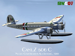
Developed from a design of Ing. Zappata, the first prototype of this entirely wooden construction seaplane, flown by test pilot Stoppani, did its maiden flight, powered by three American made Wright Cyclone, in August 1936 and gained immediately eight world records in speed and two in altitude in the seaplane category. Successive versions, powered by three Alfa Romeo 126 RC10 (later RC34), gained another 16 world records. These airplanes (A or C) were intended for commercial transport of 12/14 passengers, 25 of them were employed by 'Ala Littoria' Company on Mediterranean routes, the Royal Italian Air Force bought another 13 similar aircraft. During WWII all the civilian aircraft, acquired by Regia Aeronautica (Royal Italian Air Force), were used in communication and SAR roles.
Complete aircraft. 3 Different Hi-Res GMax models (3 different versions), features the usual moving parts, such as all flight controls, props pitch and navlights; Six different liveries (for A and C versions); 2D panel only (NO VC). Created by Manuele Villa , July 2007. Installation instructions included.
| Filename: | Ala_Littoria__CRDA_CantZ506A__C.zip |
| License: | Freeware |
| Added: | 10th May 2010, 07:25:44 |
| Downloads: | 3,556 |
| Author: | Manuele Villa |
| Size: | 21.31 MB |
| Category: Flight Simulator 2004 - Scenery | |
| New! AVIOSUPERFICI ITALIANE 2026 (The Methuselah Project) - Aviosuperficie di Le Chatelair |
|
Images related to this file:
File Description:
2nd upload and step of ITALIAN AIRSTRIPS 2026 (The Methuselah Project)
Aviosuperficie di Le Chatelair (città NUS, provincia Aosta, regione Valle d’Aosta - Italia)
This airfield is home to the Corrado Gex Aeroclub and the International Mountain Flying School; it is just over 4 km (east) from the Aosta Valley Airport and about 8 km (northeast) from the Chamois Altiporto, the first in Italy at an altitude of 1,820 m. Radio frequency 130.00 active; hangar facilities are available, but not mechanics or refueling.
Pay attention when maneuvering to the nearby power lines, parallel to runway 28; railway line on the opposite side of the power line; hangar opening with Com2 radio freq. 115.
This scenery was created using A.D.E. v1.65 and integrated libraries.
The third and final airfield in the Region is Aereoporto Valle di Aosta, which is already available for FS9 (see the details in the project summary table... https://drive.google.com/file/d/1qT7ZCUhE6ZqCzfjZe9kJM_Y0qhBNNnnN/view?usp=sharing
| Filename: | AVIOSUPERFICI_ITALIANE_2026_The_Methuselah_Project.zip |
| License: | Freeware |
| Added: | 2nd November 2026, 14:51:37 |
| Downloads: | 22 |
| Author: | Aldo Della Vedova and Gian Mario Verga |
| Size: | 3.26 MB |
| Category: Flight Simulator 2004 - Flight Plans | |
| PMDG SIDSTARS Update for KSLC Salt Lake Intl |
|
File Description:
Cycle 0604 PMDG SIDSTAR file by Terry Yingling revised 4/22/2006 by Dan Downs for KSLC Salt Lake City Intl. All SID, STAR and ILS procedures edited as required to comply with current charts. Altitude/speed constraints added to STARS. All ILS approaches updated with hard constraint at GS intercept and minor edit of missed appr procedures. DPs FFU6 & SEVYR1 deleted N/A runways, added HDG & vectors command per procedure. Added DP SLC9 and transitions. BEARR4 split between landing North or South; Use BEARR4.N landing North expect vectors to ILS34L or BEARR4.S landing South expect ILS16L use OGD transition. Corrected alt constraint BVL1. Added heading and vectors to JAMMN4. LHO3 split between landing North or South: Use LHO3.N landing North expect vectors to ILS34L, use LHO3.S landing South intercept ILS16L use WEBER transition. Added EKR transition to SPANE4 and split between landing North or South: Use SPANE4.N landing North use BOAGY transition to ILS34R; use SPANE4.S landing South expect vectors ILS16R after CHHIP. All procedures originally distributed in Cycle 0604, including those not modified, are included in this file.
| Filename: | PMDG_SIDSTARS_Update_for_KSLC_Salt_Lake_Intl.zip |
| License: | Freeware, limited distribution |
| Added: | 22nd April 2006, 19:14:41 |
| Downloads: | 540 |
| Author: | Dan Downs |
| Size: | 5.29 KB |
| Category: Flight Simulator 2004 - Scenery | |
| Hana Heli-Playground v1.0 |
|
Images related to this file:
File Description:
Hana Airport is a regional airport of the State of Hawaii on the east shore of the island of Maui, 3 NM northwest of the unincorporated town of Hana. The airport covers 119 acres and has one runway. It is primarily a commuter facility used by unscheduled air taxis and general aviation. This scenery is intended as a single/multiplayer helicopter obstacle course where heli pilots can meet to compete, show off, and share their helo skills. Since birdseye (Timm Turner) already did a neat scenery called Hana_Scenery_PHHN (search for "hana" in the HoverControl Downloads), we decided to convert PHHN to a full helicopter training area. Makes a great place for helo pilots to gather to practice and perfect their skills, and challenge other pilots! And keep an eye-out for that Hot Air Balloon, cruising around an altitude of 3000 feet (don't forget to wave at them!).
Another unique thing about this scenery is the neighboring islands (Honolulu Intl/Hickam AFB, Bellows AFB, Lanai City, Kahului, Molokai, etc). If you get frustrated during your heli obstacle course training, just take a heading of 275°, and relax at one of the neighboring islands.
| Filename: | Hana_HeliPlayground_v10.zip |
| License: | Freeware |
| Added: | 9th May 2010, 11:29:39 |
| Downloads: | 524 |
| Author: | Bob Ferguson |
| Size: | 27.79 MB |
| Category: Flight Simulator 2004 - Aircraft Repaints, Textures and Modifications | |
| Air Canada "Gimli Glider" Boeing 767-233 (C-GAUN) |
|
Images related to this file:
File Description:

SkySpirit2010 767-200 v5. FS2004 and FSX package! Model features High resolution textures, Dynamic flexing wings, Body gear steering, Nose gear steering, Rudder lock, Ground spoilers, Low speed aileron locks at high speed, Fully animated control surfaces, Fully independent suspension, Trim Animation, Opening Passenger Doors, Animated tilting bogies, Rolling wheels, Animated thrust reverser's with reverser block doors, Detailed textures, Full night lighting, Crash affects, Ground Service Vehicles And more. Model Designer Hiroshi Igami/Yosuke Ube. Flight Dynamics Designer Warren C. Daniel. Textures by Philip Foglar. Livery by Stephen Groom
The Gimli Glider is the nickname of an Air Canada aircraft that was involved in a notable aviation incident in July 1983. On 23 July, Air Canada Flight 143, a Boeing 767-233 jet, ran out of fuel at an altitude of 41,000 feet (12,500 m) ASL, about halfway through its flight from Montreal to Edmonton via Ottawa. The crew was able to glide the aircraft safely to an emergency landing at Gimli Industrial Park Airport, a former Royal Canadian Air Force base in Gimli, Manitoba. The plane survived and flew for Air Canada until its retirement in 2008
| Filename: | Air_Canada_Gimli_Glider_Boeing_767233_CGAUN.zip |
| License: | Freeware, limited distribution |
| Added: | 3rd February 2013, 22:46:43 |
| Downloads: | 1,626 |
| Author: | Stephen Groom / Skyspirit 2010 |
| Size: | 10.59 MB |
| Category: Flight Simulator 2004 - Utilities | |
| GPS GARMIN 400 Series Trainer |
|
File Description:
The 400 Series Trainer provides a completely functional simulator for the unit of your choice. In addition, you get the capability to simulate the plane’s location, speed, altitude, heading, and selected course input. These features allow you to practice basic operations such as the power-on sequence, frequency selection, and page selection. You may also practice the more advanced features such as flight plan navigation and approach procedure navigation.
In addition to providing the capability to simulate free flight for any desired course, the Trainer allows you to simulate some of the practice flights described in the pilot’s guide. These practice scenarios automatically fly the plane in a playback mode so you can concentrate more closely on the system’s operation.
While the 400 Series Trainer may be fun to fly, its primary intent is to help you become acquainted with the many powerful features provided by the real unit. You can learn to use a wealth of situational awareness features of the 400 Series from the comfort and safety of a personal computer, so that you can fly safely and more efficiently.
This is a GPS Trainer Utility
| Filename: | GPS_GARMIN_400_Series_Trainer.zip |
| License: | Freeware |
| Added: | 27th August 2003, 19:43:07 |
| Downloads: | 6,444 |
| Author: | Dirk H Uys |
| Size: | 13.25 MB |
| Category: Flight Simulator 2004 - Scenery | |
| Denver (KDEN), Colorado, Photo-Scenery |
|
Images related to this file:
File Description:
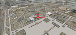
Denver (KDEN), Colorado, Photo-Scenery for FS9 & FSX.
This package covers Denver, the capital of Colorado which is also nicknamed Mile-High City because its elevation is one mile (5.280 ft). The sixth RW (16R/34L) of Denver Int'l. Airport (KDEN) is the longest commercial RW in the US with a length of 16.000ft. This allows fully loaded B747's to take off in Denvers mile-high altitude during hot summer days, when density altitudes can approach 9.000(!) ft.
KDEN is a major hub for United Airlines and the headquarters for Frontier Airlines. The airports distinctive white tent-like fabric roof is designed to be reminiscent of the snow-covered peaks of the Rocky Mountains which you can see on approach or departure.
Other important airports covered by this region are Centennial Airport (KAPA), Buckley AFB (KBKF) and Rocky Mountain Metropolitan Airport (KBJC). Extends my Mt.Evans/Georgetown package to the east and provides another 3.500 sq km in 4.7m/pix quality.
High resolution versions for FS9 and FSX (much sharper, but larger and multiple downloads) are available at www.blueskyscenery.com/GNB_SouthEast.html
. The screenies are taken from the high-res versions, so expect this version to be slightly more blurry. YourDonation@Work: Dedicated to Mark and Charles. Thanks!
| Filename: | Denver_KDEN_Colorado_PhotoScenery.zip |
| License: | Freeware, limited distribution |
| Added: | 31st October 2009, 11:24:39 |
| Downloads: | 7,292 |
| Author: | Gottfried Razek, blueskyscenery.com |
| Size: | 95.21 MB |
| Category: Flight Simulator 2004 - AFCAD Files | |
| Connellan Airports |
|
File Description:
Connellan Airways was formed in 1939 (known as Survey & Inland Transport until 1943) and the 1967 schedules show 114 airports and airstrips served by the airline across Northern Territory of Australia and reaching out into Western Australia, South Australia and Queensland too (including two named Springvale many miles apart!). It operated until 1980 when it was sold to East West Airlines. The airport at Ayers Rock, once their headquarters, has been named after the airline.
Of those 114 airports and airstrips, very few appear in Flight Simulator or in any add-on I have come across. This package seeks to redress the situation with 81 new A&FD files, representing new airports plus a couple of default ones enhanced with parking spots. Most of the airstrips remain in use today serving remote cattle stations and townships but satellite data shows a few to now be overgrown and out of use. A few cannot be traced owing to poor quality satellite imagery and have had to be omitted here.
All files are based on satellite data including altitude, and therefore work best with a high quality mesh add-on - they will still work with the default landscape of Flight Simulator but some airstrips may look a little high or low compared with the surroundling area.
| Filename: | Connellan_Airports.zip |
| License: | Freeware |
| Added: | 16th June 2015, 14:45:11 |
| Downloads: | 128 |
| Author: | John Hinson |
| Size: | 155.17 KB |
| Category: Flight Simulator 2004 - Scenery | |
| Hana Heli-Obstacle Course v2.0 |
|
Images related to this file:
File Description:
Hana Airport is a regional airport of the State of Hawaii on the east shore of the island of Maui, 3 NM northwest of the unincorporated town of Hana. The airport covers 119 acres and has one runway. It is primarily a commuter facility used by unscheduled air taxis and general aviation. This scenery is intended as a single/multiplayer helicopter obstacle course where heli pilots can meet to compete, show off, and share their helo skills. Since birdseye (Timm Turner) already did a neat scenery called Hana_Scenery_PHHN (search for "hana" in the HoverControl Downloads), we decided to convert PHHN to a full helicopter training area. Makes a great place for helo pilots to gather to practice and perfect their skills, and challenge other pilots! And keep an eye-out for that Hot Air Balloon, cruising around an altitude of 3000 feet (don't forget to wave at them!). Another unique thing about this scenery is the neighboring islands (Honolulu Intl/Hickam AFB, Bellows AFB, Lanai City, Kahului, Molokai, etc). If you get frustrated during your heli obstacle course training, just take a heading of 275 degrees, and relax at one of the neighboring islands. We also added an Easter Egg - If you set your FS calendar to July 21st, you'll see a large ridge fire up in the hills. Load Jordan Moore's Erickson S64E (http://www.hovercontrol.com/) & try your skills at water bombing!
| Filename: | Hana_HeliObstacle_Course_v20.zip |
| License: | Freeware |
| Added: | 7th December 2010, 03:28:47 |
| Downloads: | 476 |
| Author: | Greg Spellmen & Bob Ferguson |
| Size: | 58.56 MB |
| Category: Flight Simulator 2004 - Scenery | |
| Hana Heli-Obstacle Course v3.0 |
|
File Description:
Hana Airport is a regional airport of the State of Hawaii on the east shore of the island of Maui, 3 NM northwest of the unincorporated town of Hana. The airport covers 119 acres and has one runway. It is primarily a commuter facility used by unscheduled air taxis and general aviation. This scenery is intended as a single/multiplayer helicopter obstacle course where heli pilots can meet to compete, show off, and share their helo skills. Since birdseye (Timm Turner) already did a neat scenery called Hana_Scenery_PHHN (search for "hana" in the HoverControl Downloads), we decided to convert PHHN to a full helicopter training area. Makes a great place for helo pilots to gather to practice and perfect their skills, and challenge other pilots! And keep an eye-out for that Hot Air Balloon, cruising around an altitude of 3000 feet (don't forget to wave at them!).
Another unique thing about this scenery is the neighboring islands (Honolulu Intl/Hickam AFB, Bellows AFB, Lanai City, Kahului, Molokai, etc). If you get frustrated during your heli obstacle course training, just take a heading of 275 degrees, and relax at one of the neighboring islands. We also added an Easter Egg - If you set your FS calendar to July 21st, you'll see a large ridge fire up in the hills. Load Jordan Moore's Erickson S64E (http://www.hovercontrol.com/) & try your skills at water bombing!
| Filename: | Hana_HeliObstacle_Course_v30.zip |
| License: | Freeware |
| Added: | 28th August 2011, 17:53:18 |
| Downloads: | 470 |
| Author: | Greg Spellmen, Bob Ferguson |
| Size: | 95.52 MB |


© 2001-2026 AVSIM Online
All Rights Reserved
Privacy Policy |