
Where Flight Simulation Enthusiasts Gather from Around the World!
AVSIM Library - Search Results

| Category: Flight Simulator X - Scenery | |
| UTFN - Namangan, Uzbekistan |

|
Images related to this file:
File Description:
This is fictional scenery for Namangan (UTFN), Uzbekistan, designed for FSX.
I created this scenery to be more representative of the real life airport. I accomplished this by making modifications to the stock airport, using Google Satellite images and pictures for guidance. Also pictures of the terminal when they are available.
Here is what to look for in this scenery package:
- Added a custom made terminal as depicted in actual airport pictures.
- Added apron and taxiways as depicted in the actual airport pictures.
- Added a couple of hangers and SU-35 aircraft parked on the apron.
- Added a fire station and Control Tower.
- Flattened the terrain on the runway because part of the it was underground.
- Deleted a few trees on both approaches.
| Filename: | UTFN__Namangan_Uzbekistan.zip |
| License: | Freeware |
| Added: | 28th May 2014, 10:56:00 |
| Downloads: | 553 |
| Author: | Ed Bleck |
| Size: | 1.14 MB |
| Category: Flight Simulator X - Gauges | |
| FLTInfo V2 |
|
Images related to this file:
File Description:
This gauge has been developed for FSX Flight Simulator SP2 or SP1. It should also work with Acceleration, but this is not guaranteed by the author.
The gauge provides flight information for the pilot regarding the destination airport in terms of frequencies, runway conditions, altitude, bearing and distance, and basic information about the flight plan like current travelled miles and a estimated calculation about the Top Of Descent (TOD ) decision point.
This Version 2 includes 3 additional information pages for the runway layouts of the destination and the departure airport, and a page which provides graphical information about the terrain level relative to the aircraft on the selected flight plan.
For more information and installation instructions see the documentation inside the zip file.
| Filename: | FLTInfo_V2.zip |
| License: | Freeware, limited distribution |
| Added: | 12th October 2012, 18:05:11 |
| Downloads: | 1,553 |
| Author: | Dietmar Loleit |
| Size: | 853.38 KB |
| Category: Fly! II - Scenery | |
| Globe Tile D199159 gxx.trn Files |
|
File Description:
This Fly!2 upload contains four edited gxx.trn files which flatten the bodies of water in globe tile D199159. This globe tile, which includes Pittsburgh (KPIT lies just outside the border) is south of its companion globe tile D199160, whose gxx.trn files I uploaded previously. The edited gxx.trn files flatten the Allegheny R., Ohio R. and all streams flowing from the Pittsburg area. Special attention was paid to the Kiskiminetas R. and Conemaugh R. and river cuts thru ridges west of Johnstown. Terrain elev. just West of JST and East of KAGC were also adjusted for more pleasing effects.
Important: the globe tile was rendered with options set for subdivideDensity=8 and subdivideTolerance=500. Border areas were not edited to avoid compatibility problems with bordering globe tiles.
| Filename: | Globe_Tile_D199159_gxxtrn_Files.zip |
| License: | Freeware |
| Added: | 2nd September 2002, 17:07:13 |
| Downloads: | 175 |
| Author: | Mark Steinmetz |
| Size: | 223.59 KB |
| Category: Flight Simulator 2004 - Utilities | |
| TexPand2 |
|
File Description:
With the proliferation of Flight Simulator add-ons which modify scenery texture files, it may occasionally be necessary to restore files originally installed by FS2004. “TexPand2” can be useful when you have a texture file problem and you wish a solution less drastic than re-installing the entire Flight Simulator package. Use this utility if you wish to install an add-on which requires the original files to be present, or if you wish to remove any texture, water, cloud, or night lighting add-on such as NuRoads©, Ultimate Terrain©, BirdsEyeView©, Flight Environment©, Silver Wings, or add-ons which have no “UNINSTALL” feature. READ INSTRUCTIONS BEFORE USING! Requires FS2004 original install disks. Freeware By Frank Bergson
| Filename: | TexPand2.zip |
| License: | Freeware |
| Added: | 10th December 2005, 23:14:49 |
| Downloads: | 1,933 |
| Author: | Frank Bergson |
| Size: | 729.4 KB |
| Category: Flight Simulator 2004 - Scenery | |
| Southern California Oilrigs v2.0 |
|
File Description:
This is a revised version of my previous rendition of the Oil Rigs off the Southern California Coastline. This file acurately represents the positions of ALL of the Oilrigs extending from Lompoc to Newport Beach, California. Also included are 4 lighthouses not placed in the FS2004 Default Scenery located from Morro Bay - Point Conception, California. * * REQUIRES RWY 12 * * This add-on was created with Runway 12 add-on, so you must have this add-on installed, or at least the scenery BGL and Texture files installed in your Addon Scenery\Static Objects Library folder for the scenery to work. In addition, the scenery was created while using Ultimate Terrain USA, so default FS2004 Scenery users may have some scenery items in slightly different places.
| Filename: | Southern_California_Oilrigs_v20.zip |
| License: | Freeware |
| Added: | 24th September 2005, 18:43:11 |
| Downloads: | 1,328 |
| Author: | Brian C. Selb |
| Size: | 63.56 KB |
| Category: Flight Simulator 2004 - Scenery | |
| Cavanaugh Bay 66S Idaho Airport |
|
File Description:
Priest Lake in Idaho is described by their Chamber of Commerce as "...a magnificent 23,000 acre azure lake nestled beneath the majestic Selkirk Mountains — without question, one of the most beautiful wilderness areas you’ll ever see." Cavanaugh Bay is a grass strip right on the lake, with lodges (there's one right next to the end of the runway), campgrounds and boat/plane docks nearby. I think I was able to make a fair approximation of the real thing, based on Google Earth. If you're flying something that floats, choosing RWY S or RWY E from the FS9 airport menu will park you conveniently at a floatplane dock. This scenery was designed for use with Ultimate Terrain USA and has not been tested with the default FS9 scenery.
| Filename: | Cavanaugh_Bay_66S_Idaho_Airport.zip |
| License: | Freeware |
| Added: | 14th July 2008, 13:38:40 |
| Downloads: | 608 |
| Author: | Sidney Schwartz |
| Size: | 654.43 KB |
| Category: Flight Simulator 2004 - Scenery | |
| Pinal Airpark KMZJ |
|
File Description:
FS2004 Scenery - Pinal Airpark (IATA: MZJ, ICAO: KMZJ) is an airport located in Pinal County, seven miles (11 km) northwest of the central business district (CBD) of Marana, a city in Pima County, Arizona, USA. Its main purpose is to act as a "boneyard" for aircraft. Old airplanes are stored there with the hope that the dry desert climate will prevent rust and other forms of corrosion in case the aircraft is pressed into service in the future. Even so, many aircraft which are brought there wind up being scrapped. Nearby Davis-Monthan Air Force Base provides the same service to the U.S. military. Compatible with both FS default and Ultimate Terrain. EZ Scenery Libraries required. Some included. by JOhn B. Loney, Jr.
| Filename: | Pinal_Airpark_KMZJ.zip |
| License: | Freeware, limited distribution |
| Added: | 16th March 2008, 05:46:41 |
| Downloads: | 1,623 |
| Author: | John B. Loney, Jr. |
| Size: | 7.14 MB |
| Category: Flight Simulator X - Scenery | |
| channel ships |
|
File Description:
Ships, loads of ships in the English Channel (excusee: Pas de Calais)
About 60 ships (apart from ai ships)
When flying over the Channel, pilots say that an emergency landing here would certainly mean a crash into a ship; there are that many ships about.
You'll see Cargo ships, containerships, super tankers. Cruisliners are symbolic for the ferries sailing to and from Calais / Dover and Dunkirk.
Corrected for use with Ultimate terrain Europe
To be able to see this scenery I had to make a fake airport and named it LF00 (read: LF zero-zero)
There's a tower position as well, midways the channel with a height of 100 mtr. I haven’t tested it, it's not visible either.LF00 is visible in your GPS. Have fun.
| Filename: | channel_ships.zip |
| License: | Freeware, limited distribution |
| Added: | 12th January 2009, 13:00:36 |
| Downloads: | 3,771 |
| Author: | Joost Visser / ade1.37 |
| Size: | 134.43 KB |
| Category: Flight Simulator 2004 - Aircraft Repaints, Textures and Modifications | |
| World Fish & Agriculture Inc. "Winkys Fish" Lockheed R7V-1 / C-121J |
|
Images related to this file:
File Description:
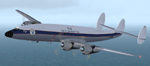
Textures for Lockheed R7V-1/C-121J by Team 1049 - Roland Berger, Volker Boehme, Manfred Jahn, Luis Pallas, Bill Tyne and Stefan Werner. Repainted by Manfred Meyer.
A working installation of the G and H Super Constellation packs (L1049H.ZIP, L1049GZIP and r7v-1.ZIP)is required, use the 1049vc_rf model for this textures!
This aircraft was built 1953 as a R7V-1 BuNo 131643 for US Navy (c/n 4144) and 1960 redesignated as C-121J. Serving whis the Point Mugu Missile Range it was known as the "Ole Blue from Point Mugu". 1974 withdrawn from use and stored at Davis Monthan, she was sold in May 1981 to William "Winky" Crawfords Northern Peninsula Fisheries Corp. and reg. N4247K for hauling salmon in Alaska. After modification work to civil freighter in 1987 the Connie went to World Fish & Agriculture Inc. Cold Bay Alaska, another Crawford Company. Now it was the plan to hauling thunafish from Palau Island to Nagoya in Japan. It was intend to carry 38 000 lbs of fish per trip but only 33 000 lbs were practial. But the contract could not be fullfiled because no high grade AVGAS was available at Nagoya. The aircraft has to carry return fuel in drums, which reduced the payload further to only 15 000 lbs.
Only a few roundtrips were flown in 1988 and then the Connie was impounted and stored at Manila apt. due to lawsuit actions with the contractors. She remains abandonded in open storage at Manila until 2014 as the Quantas Museum from Australia bought her in auction for spares.
| Filename: | World_Fish__Agriculture_Inc_Winkys_Fish_Lockheed_R.zip |
| License: | Freeware |
| Added: | 17th November 2014, 22:44:15 |
| Downloads: | 156 |
| Author: | Manfred Meyer |
| Size: | 5.62 MB |
| Category: Flight Simulator X - Aircraft Repaints, Textures and Modifications | |
| RCAF "440 Sqn" de Havilland Canada DHC-6 Twin Otter -100 and -300 versions |
|
Images related to this file:
File Description:

For the Aerosoft Twin Otter Extended, 2 sets of skins, one "Normal" without mipmaps and one "x4096" with mipmaps, each set contains:
1 -100 skin for the 3 Blades Cargo version,
1 -100 skin for the 3 Blades Floats version,
1 -300 skin for the 3 Blades Cargo version,
1 -300 skin for the 3 Blades Tundra Cargo version,
1 -300 skin for the 4 Blades Cargo version,
1 -300 skin for the 3 Blades Skiwheel version,
1 -300 skin for the 3 Blades Amphibian version.
| Filename: | RCAF_440_Sqn_de_Havilland_Canada_DHC6_Twin_Otter_1.zip |
| License: | Freeware |
| Added: | 3rd December 2013, 15:26:20 |
| Downloads: | 1,192 |
| Author: | Tom Weiss |
| Size: | 253.77 MB |


© 2001-2026 AVSIM Online
All Rights Reserved
Privacy Policy |