|
AVSIM Library - Search Results
|
|
Login | Register | About logging in and out
|
Searching for:
Author matching 'Razek'
in Flight Simulator 2004 - Scenery and below.
|

|
|
|
|
|
|
Images related to this file:
|
File Description:
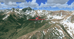
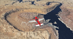
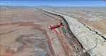
There sure is more than one reason to go to Aspen and this is sure another must-have of my Colorado sceneries. If you're coming IFR there's a couple of very demanding approach procedures. From a LOC/DME to several visual approaches there's everything your heart might desire. Due to the steep and high surrounding terrain these are quiet some hair raisers (see www.airnav.com/airport/KASE). If you're coming VFR then the traffic pattern altitude is 9.005 ft for light aircraft (vs. 9.505 for aircraft 12.500 lbs or more). Weather and wind permitting, RW15 is preferred for all landings (left pattern). RW33 has a right pattern and is preferred for all takeoffs. You even need a written permission to depart RW15. When departing VFR make a right turn to a heading of 360 degrees ASAP for noise abatement and hold this heading for at least 2 miles from the field. And don't forget to enjoy the impressive mountain scenery with two 14ers: Snowmass Mtn. and Castle Pk. to the southwest. This scenery brings you another 3.500 sq km of beautiful Colorado in 4.7m/pix quality. High resolution versions of this scenery for FS9 and FSX (much sharper, but larger and multiple downloads) are available at www.blueskyscenery.com/GNB_South2West2.html . The screenies are taken from the high-res versions, so expect this version to be slightly more blurry. YourDonation@Work: Dedicated to Mark, Markus and Yves.
|
| Filename: |
gnb_south2west2_2010_lr.zip |
| License: |
Freeware, limited distribution |
| Added: |
30th January 2010, 17:04:55 |
| Downloads: |
3506 |
| Author: |
Gottfried Razek - blueskyscenery.com |
| Size: |
94719kb |
|
|
Images related to this file:
|
File Description:
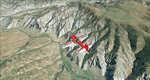
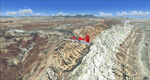
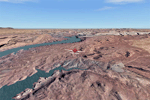
To explore this region depart from Eagle County Regional Airport (KEGE) which is a popular regional airport used in winter to transport skiers to nearby Vail. Northwest of the airport you can see the pit gypsum mine of American Gypsum which produces a variety of wallboard products. When you fly to the west and along the Eagle River, you soon pass its confluence with the Colorado River. Further west you can fly along Glennwood Canyon and finally reach Glennwood Springs where the Colorado meets the Roaring Fork River. Here you can turn south and fly direct Glenwood Springs Airport (KGWS) which lies south of the city. This scenery brings you another 3.500 sq km of beautiful Colorado in 4.7m/pix quality.
High resolution versions of this scenery for FS9 and FSX (much sharper, but larger and multiple downloads) are available at www.blueskyscenery.com/GNB_SouthWest2.html . The screenies are taken from the high-res versions, so expect this version to be slightly more blurry. YourDonation@Work: Dedicated to Alain and James.
|
| Filename: |
gnb_southwest2_2010_lr.zip |
| License: |
Freeware, limited distribution |
| Added: |
30th January 2010, 17:01:49 |
| Downloads: |
2651 |
| Author: |
Gottfried Razek - blueskyscenery.com |
| Size: |
96052kb |
|
|
Images related to this file:
|
File Description:
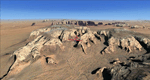
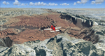
This package contains the center of Lake Powell and the Navajo Nation around Navajo Mountain. It contains remote areas of stunning beauty. Wonderful sandstone formations in bright shades of red and pink. Contains landmarks like the Rainbow Bridge National Monument and the confluence of the Colorado and San Juan Rivers. Extends my Monument Valley scenery to the west and brings you another 3.500 sq km in 4.7m/pix quality. To explore the scenery depart from Navajo Mountain dirt strip (04UT). High resolution versions of this scenery for FS9 and FSX (much sharper, but larger and multiple downloads) are available at www.blueskyscenery.com/CNY_South3West2.html . The screenies are taken from the high-res versions, so expect this version to be slightly more blurry. YourDonation@Work: Joaquin, Donald and Scott.
|
| Filename: |
cny_south3west2_2010_lr.zip |
| License: |
Freeware, limited distribution |
| Added: |
23rd January 2010, 23:06:49 |
| Downloads: |
1709 |
| Author: |
Gottfried Razek - blueskyscenery.com |
| Size: |
93629kb |
|
|
Images related to this file:
|
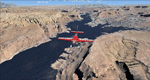
File Description:
Monument Valley, Kayenta (0V7), Utah/Arizona, Photo-Scenery (FS9 & FSX)
This scenery covers the area from south of the San Juan River down to wonderful Monument Valley and Kayenta, AZ.
It extends my Lake Powell sceneries to the south and brings you another
3.500 sq km in 4.7m/pix quality. To explore the scenery depart from Kayenta (0V7) and head north.
High resolution versions of this scenery for FS9 and FSX (much sharper, but larger and multiple downloads) are available at www.blueskyscenery.com/CNY_South3West.html . The screenies are taken from the high-res versions, so expect this version to be slightly more blurry. YourDonation@Work: Dedicated to Thomas, Don and Eric.
|
| Filename: |
cny_south3west_2010_lr.zip |
| License: |
Freeware, limited distribution |
| Added: |
23rd January 2010, 10:45:32 |
| Downloads: |
2236 |
| Author: |
Gottfried Razek - blueskyscenery.com |
| Size: |
95734kb |
|
|
Images related to this file:
|
File Description:
This scenery covers the area from the southern end of the Waterpocket Fold down to the Bullfrog Basin and the eastern end of the Kiaparowits Plateau. It extends my Canyonlands sceneries to the southwest and brings you another 3.500 sq km in 4.7m/pix quality. To explore the scenery depart from Bullfrog Basin Airport (U07) and west. High resolution versions of this scenery for FS9 and FSX (much sharper, but larger and multiple downloads)
are available at www.blueskyscenery.com/CNY_South2West2.html . The screenies are taken from the high-res versions, so expect this version to be slightly more blurry. YourDonation@Work: Dedicated to Jean-Marc, Jim and Cay.
|
| Filename: |
cny_south2west2_2010_lr.zip |
| License: |
Freeware, limited distribution |
| Added: |
18th January 2010, 19:27:52 |
| Downloads: |
1566 |
| Author: |
Gottfried Razek - blueskyscenery.com |
| Size: |
95062kb |
|
|
Images related to this file:
|
File Description:
Capitol Reef National Park/South - Waterpocket Fold, Utah, Photo-Scenery (for FS9 & FSX)
This scenery covers the area from the southern part of Capitol Reef National Park down along the Waterpocket Fold and the Henry Mountains. It extends my Canyonlands sceneries to the west and brings you another 3.500 sq km in 4.7m/pix quality. To explore the scenery depart from Hanksville (KHVE) and head northwest. High resolution versions of this scenery for FS9 and FSX (much sharper, but larger and multiple downloads)
are available at www.blueskyscenery.com/CNY_SouthWest2.html . The screenies are taken from the high-res versions, so expect this version to be slightly more blurry. YourDonation@Work: Eric and Andy.
|
| Filename: |
cny_southwest2_2010_lr.zip |
| License: |
Freeware, limited distribution |
| Added: |
13th January 2010, 20:46:53 |
| Downloads: |
1698 |
| Author: |
Gottfried Razek - blueskyscenery.com |
| Size: |
98218kb |
|
|
Images related to this file:
|
File Description:
Capitol Reef National Park/North - Hanksville (KHVE), Utah, Photo-Scenery (for FS9 & FSX)
This scenery covers the northern part of Capitol Reef National Park, Hanksville (KHVE), the Goblin Valley and extends north to I70 and the San Rafael Swell. It extends my Canyonlands sceneries to the west and brings you another 3.500 sq km in 4.7m/pix quality. To explore the scenery depart from Hanksville (KHVE) and head northwest. High resolution versions of this scenery for FS9 and FSX (much sharper, but larger and multiple downloads) are available at www.blueskyscenery.com/CNY_West2.html . The screenies are taken from the high-res versions, so expect this version to be slightly more blurry. YourDonation@Work: Dedicated to Andy and Robert.
|
| Filename: |
cny_west2_2010_lr.zip |
| License: |
Freeware, limited distribution |
| Added: |
13th January 2010, 19:32:33 |
| Downloads: |
1666 |
| Author: |
Gottfried Razek, blueskyscenery.com |
| Size: |
97043kb |
|
|
Images related to this file:
|
File Description:
Lake Powell East / Natural Bridges National Monument, Utah, Photo-Scenery (FS9 & FSX)
This scenery covers the eastern part of Lake Powell from just south of Hite (UT03) and goes down south along White Canyon, Natural Bridges National Monument and the Grand Gulch Primitive Area all the way to the San Juan River. It extends my Canyonlands sceneries to the south and brings you another 3.500 sq km of wonderful southern Utah in 4.7m/pix quality. To explore the scenery depart from Cal Black Memorial Apt. (U96) and head east. High resolution versions of this scenery for FS9 and FSX (much sharper, but larger and multiple downloads) are available at www.blueskyscenery.com/CNY_South2West.html. The screenies are taken from the high-res versions, so expect this version to be slightly more blurry. YourDonation@Work: Dedicated to Guy, Ruben and EDB.
|
| Filename: |
cny_south2west_2010_lr.zip |
| License: |
Freeware, limited distribution |
| Added: |
4th January 2010, 19:19:43 |
| Downloads: |
1836 |
| Author: |
Gottfried Razek, blueskyscenery.com |
| Size: |
97544kb |
|
|
Images related to this file:
|
File Description:
Blanding (KBDG), Utah, Photo-Scenery (FS9 & FSX)
This scenery covers the area around Blanding, Utah (KBDG), extending from just south of Monticello to Bluff (66V) and the northern part of the Comb Ridge. It extends my Canyonlands sceneries to the south and brings you another 3.500 sq km of wonderful southern Utah in 4.7m/pix quality. To explore the scenery depart from Blanding (KBDG). High resolution versions of this scenery for FS9 and FSX (much sharper, but larger and multiple downloads) are available at
www.blueskyscenery.com/CNY_South2.html. The screenies are taken from the high-res versions, so expect this version to be slightly more blurry. YourDonation@Work: Dedicated to Joseph, Rainer and Cesare.
|
| Filename: |
cny_south2_2010_lr.zip |
| License: |
Freeware, limited distribution |
| Added: |
4th January 2010, 19:09:22 |
| Downloads: |
1591 |
| Author: |
Gottfried Razek, blueskyscenery.com |
| Size: |
98095kb |
|
|
Images related to this file:
|
File Description:
This is a re-upload of a package that was corrupted during the crash of the AVSIM library. This is the fourth package of the Arches/Canyonlands area. It covers the area southwest and including the confluence of the Colorado and Green Rivers. From there you can fly down Cataract Canyon which is famed for its premium whitewater rafting oportunities. Or explore the Maze (the area west of the Green and north of the Colorado River) with it's labyrinth of canyons and colorful sandstone formations. The scenery extends west to Hite (UT03) on Lake Powell. Brings the total Southern Utah coverage to 14.000 sq km in 4.7m/pix quality. YourDonation@Work: Dedicated to Patrick, Hideyuki and Art. Thanks!
|
| Filename: |
cny_southwest2009_lr.zip |
| License: |
Freeware, limited distribution |
| Added: |
31st December 2009, 22:33:46 |
| Downloads: |
2051 |
| Author: |
Gottfried Razek - blueskyscenery.com |
| Size: |
97965kb |
|
  |


