
Where Flight Simulation Enthusiasts Gather from Around the World!
AVSIM Library - Search Results

| Category: Flight Simulator 2004 - Scenery | |
| Lake Powell East / Natural Bridges National Monument, Utah, Photo-Scenery |

|
Images related to this file:
File Description:
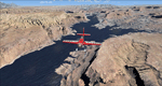
Lake Powell East / Natural Bridges National Monument, Utah, Photo-Scenery (FS9 & FSX)
This scenery covers the eastern part of Lake Powell from just south of Hite (UT03) and goes down south along White Canyon, Natural Bridges National Monument and the Grand Gulch Primitive Area all the way to the San Juan River. It extends my Canyonlands sceneries to the south and brings you another 3.500 sq km of wonderful southern Utah in 4.7m/pix quality. To explore the scenery depart from Cal Black Memorial Apt. (U96) and head east. High resolution versions of this scenery for FS9 and FSX (much sharper, but larger and multiple downloads) are available at www.blueskyscenery.com/CNY_South2West.html. The screenies are taken from the high-res versions, so expect this version to be slightly more blurry. YourDonation@Work: Dedicated to Guy, Ruben and EDB.
| Filename: | Lake_Powell_East__Natural_Bridges_National_Monumen.zip |
| License: | Freeware, limited distribution |
| Added: | 4th January 2010, 19:19:43 |
| Downloads: | 1,871 |
| Author: | Gottfried Razek, blueskyscenery.com |
| Size: | 95.26 MB |
© 2001-2026 AVSIM Online
All Rights Reserved
Privacy Policy |