|
AVSIM Library - Search Results
|
|
Login | Register | About logging in and out
|
Searching for:
Author matching 'Razek'
in Flight Simulator 2004 - Scenery and below.
|

|
|
|
|
|
|
Images related to this file:
|
File Description:
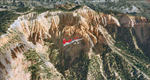
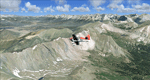
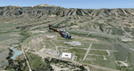
Bryce Canyon National Park (KBCE), Utah, Photo-Scenery (FS9 & FSX)
Despite its name, Bryce Canyon is not actually a canyon that was formed by a river, but rather a giant natural cliff shaped through erosion by wind, water, and ice. Bryce is distinctive due to its geological formations, delicate and colorful pinnacles called hoodoos that are up to 200ft high. The bizarre forms and red, orange and white colors of the rocks provide spectacular views. Unfortunately the hoodoos are too small for the elevation mesh in flight simulator. But you can enjoy the colors and shape of the cliffs. The cliffs in main region of the park, just south of the airport are partly covered
by snow. But on the southern and western part of the plateau you can enjoy them free of snow. Bryce Canyon is named after the Mormon pioneer Ebenezer Bryce who settled in this area in the 1850s. It was designated as a national park in 1928.
Bryce Canyon Airport (KBCE) just handles small aircraft on a daily basis. But is was actually built to handle larger aircraft in case of emergency. And so on Oct.6th 2000 an American Airlines MD-82 from Denver to Los Angeles made a successful emergency landing after reporting smoke in the cockpit and a loss of cabin pressure.
High resolution versions of this scenery for FS9 and FSX (much sharper, but larger and multiple downloads)are available at www.blueskyscenery.com/CNY_South2West4.html . The screenies are taken from the high-res versions, so expect this version to be slightly more blurry. Thanks to Joop Mak for providing a custom AFCADs that correct airport layouts so that they align with the photo-textures! They are available here: www.blueskyscenery.com/AFCADs.html . YourDonation@Work: Dedicated to Michael, Pat and Keith.
|
| Filename: |
cny_south2west4_2010_lr.zip |
| License: |
Freeware, limited distribution |
| Added: |
7th March 2010, 11:17:56 |
| Downloads: |
2163 |
| Author: |
Gottfried Razek, blueskyscenery.com |
| Size: |
98666kb |
|
|
Images related to this file:
|
File Description:
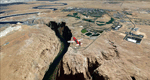
This scenery contains the eastern part of the Grand Staircase Escalante National Monument. It extends from the town of Escalante down south where it connects with the Page/Lake Powell scenery. Contains the upper part of wonderful Escalante Canyon. To explore the scenery depart from Escalante Airport (1L7). Thanks to Joop Mak for providing a custom AFCAD that corrects the airport layout so that it matches with the photo-textures! High resolution versions of this scenery for FS9 and FSX (much sharper, but larger and multiple downloads) are available at www.blueskyscenery.com/CNY_South2West3.html . The screenies are taken from the high-res versions, so expect this version to be slightly more blurry. YourDonation@Work: Dedicated to Jay, Donald and Franz
|
| Filename: |
cny_south2west3_2010_lr.zip |
| License: |
Freeware, limited distribution |
| Added: |
4th March 2010, 22:44:30 |
| Downloads: |
1458 |
| Author: |
Gottfried Razek - blueskyscenery.com |
| Size: |
98510kb |
|
|
Images related to this file:
|
File Description:
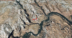
This scenery covers the western part of Lake Powell, the city of Page (KPGA), the Vermillion Cliffs, Glenn Canyon just south of Glenn Canyon Dam, the northern part of Marble Canyon, Paria Canyon, Cockscomb, etc, etc. Spectacular! To explore the scenery depart from Page Municipal Airport (KPGA). High resolution versions of this scenery for FS9 and FSX (much sharper, but larger and multiple downloads) are available at www.blueskyscenery.com/CNY_South3West3.html . The screenies are taken from the high-res versions, so expect this version to be slightly more blurry. YourDonation@Work: Dedicated to William, Veit and Michele.
|
| Filename: |
cny_south3west3_2010_lr.zip |
| License: |
Freeware, limited distribution |
| Added: |
3rd March 2010, 21:26:32 |
| Downloads: |
1756 |
| Author: |
Gottfried Razek - blueskyscenery.com |
| Size: |
94625kb |
|
|
Images related to this file:
|
File Description:
Fremont County, Colorado, Photo-Scenery (FS9 & FSX)
Covers the gap between my Buena Vista and Colorado Springs South sceneries and provides you with continuous coverage for longer cross country flights. High resolution versions of this scenery for FS9 and FSX (much sharper, but larger and multiple downloads) are available at www.blueskyscenery.com/GNB_South3.html . The screenies are taken from the high-res versions, so expect this version to be slightly more blurry. YourDonation@Work: Dedicated to Senges and Dennis.
|
| Filename: |
gnb_south3_2010_lr.zip |
| License: |
Freeware, limited distribution |
| Added: |
13th February 2010, 14:33:42 |
| Downloads: |
1302 |
| Author: |
Gottfried Razek, blueskyscenery.com |
| Size: |
94323kb |
|
|
Images related to this file:
|
File Description:
This region covers the area around Buena Vista and Central Colorado Reg. (KAEJ form. 7V1). It extends
my Leadville scenery to the south and brings you another 3.500 sq km of beautiful Colorado in 4.7m/pix quality. High resolution versions of this scenery for FS9 and FSX (much sharper, but larger and multiple downloads) are available at www.blueskyscenery.com/GNB_South3West.html . The screenies are taken from the high-res versions, so expect this version to be slightly more blurry. YourDonation@Work: Dedicated to Matias and Markus.
|
| Filename: |
gnb_south3west_2010.zip |
| License: |
Freeware, limited distribution |
| Added: |
7th February 2010, 11:31:14 |
| Downloads: |
1546 |
| Author: |
Gottfried Razek - blueskyscenery.com |
| Size: |
96141kb |
|
|
Images related to this file:
|
File Description:
Gunnison (KGUC), Colorado, Photo-Scenery (FS9 & FSX)
Extends my Aspen scenery to the south from Crested Butte to Gunnison (KGUC) and beyond. Contains the West Elk Wilderness Area and the Curecanti Nat'l. Rec. Area around Morrow Point Reservoir. This scenery brings you another 3.500 sq km of beautiful Colorado in 4.7m/pix quality.
High resolution versions of this scenery for FS9 and FSX (much sharper, but larger and multiple downloads) are available at www.blueskyscenery.com/GNB_South3West2.html . The screenies are taken from the high-res versions, so expect this version to be slightly more blurry. YourDonation@Work: Dedicated to Alain, Jacques and Lefevre.
|
| Filename: |
gnb_south3west2_2010.zip |
| License: |
Freeware, limited distribution |
| Added: |
6th February 2010, 11:08:59 |
| Downloads: |
1700 |
| Author: |
Gottfried Razek, blueskyscenery.com |
| Size: |
93008kb |
|
|
Images related to this file:
|
File Description:
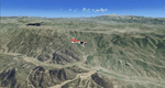
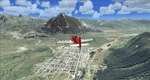
Colorado Springs South (KCOS), Colorado, Photo-Scenery (FS9 & FSX)
This region covers the area of Colorado Springs. Just west of the city you can fly around Pikes Peak. At 14.115ft it is the easternmost of Colorado's 54 fourteeners. Northwest of the city lies the Garden Of Gods with its many vertical rock formations. They are made of sedimentary beds red and white sandstones, conclomerates and limestone that were deposited horizontally but have been tilted vertically and faulted by the immense mountain building forces caused by the uplift of the Pikes Peak massiv. Deep within Chayenne Mountain is the North American Aerospace Defense Command's (NORAD) main technical facility which collects and evaluates data from a worldwide system of satellites, radars and other sensors.
High resolution versions of this scenery for FS9 and FSX (much sharper, but larger and multiple downloads) are available at www.blueskyscenery.com/GNB_South3East.html . The screenies are taken from the high-res versions, so expect this version to be slightly more blurry. YourDonation@Work: Dedicated to Veit and Hector.
|
| Filename: |
gnb_south3east_2010_lr.zip |
| License: |
Freeware, limited distribution |
| Added: |
5th February 2010, 16:30:42 |
| Downloads: |
1938 |
| Author: |
Gottfried Razek, blueskyscenery.com |
| Size: |
97923kb |
|
|
Images related to this file:
|
File Description:
Covers the gap between my Leadville and Colorado Springs North sceneries and provides you with continuous coverage for longer cross country flights. High resolution versions of this scenery for FS9 and FSX (much sharper, but larger and multiple downloads) are available at www.blueskyscenery.com/GNB_South2.html . The screenies are taken from the high-res versions, so expect this version to be slightly more blurry. YourDonation@Work: Dedicated to Arthur and Pierre-Alain.
|
| Filename: |
gnb_south2_2010_lr.zip |
| License: |
Freeware, limited distribution |
| Added: |
3rd February 2010, 22:19:58 |
| Downloads: |
1390 |
| Author: |
Gottfried Razek - blueskyscenery.com |
| Size: |
91636kb |
|
|
Images related to this file:
|
File Description:
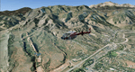
This region covers the area between Denver and Colorado Springs. It extends my Denver scenery to the south.
Just north of Colorado Springs you can see the widespread United States Air Force Academy which, with it's
many buildings, covers a huge area of 18.000 acres. The Academy Airfield (KAFF) which lays in the northeastern
corner of the area is used for training cadets in airmanship courses, including parachute training,
soaring and powered flight.
High resolution versions of this scenery for FS9 and FSX (much sharper, but larger and multiple downloads)
are available at www.blueskyscenery.com/GNB_South2East.html . The screenies are taken from the high-res versions,
so expect this version to be slightly more blurry. YourDonation@Work: Dedicated to Robin and Raymond.
|
| Filename: |
gnb_south2east_2010_lr.zip |
| License: |
Freeware, limited distribution |
| Added: |
3rd February 2010, 02:09:59 |
| Downloads: |
2149 |
| Author: |
Gottfried Razek - blueskyscenery.com |
| Size: |
99241kb |
|
|
Images related to this file:
|
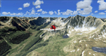
File Description:
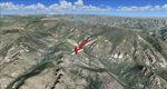
Extends my Aspen scenery to the east and contains more gorgeous Continental Divide area of the Rocky Mountains. Covers Leadville Lake County Airport (KLXV), which is the highest airport in North America (9.927 ft) and Mt. Elbert, which is the highest peak in the Rocky Mountains (14.443 ft). Aircraft performance deteriorates
with altitude, so many companies use the Leadville Airport as a base for high altitude performance testing. This scenery brings you another 3.500 sq km of beautiful Colorado in 4.7m/pix quality.
High resolution versions of this scenery for FS9 and FSX (much sharper, but larger and multiple downloads) are available at www.blueskyscenery.com/GNB_South2West.html . The screenies are taken from the high-res versions, so expect this version to be slightly more blurry. YourDonation@Work: Dedicated to Daniel, Art and Rotui.
|
| Filename: |
gnb_south2west_2010_lr.zip |
| License: |
Freeware |
| Added: |
1st February 2010, 19:06:58 |
| Downloads: |
1673 |
| Author: |
Gottfried Razek - blueskyscenery.com |
| Size: |
96957kb |
|
  |


