
Where Flight Simulation Enthusiasts Gather from Around the World!
AVSIM Library - Search Results

| Category: Flight Simulator 2004 - Scenery | |
| Lake Powell - Bullfrog Basin (U07), Utah, Photo-Scenery (FS9 & FSX) |

|
Images related to this file:
File Description:
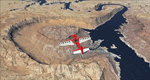
This scenery covers the area from the southern end of the Waterpocket Fold down to the Bullfrog Basin and the eastern end of the Kiaparowits Plateau. It extends my Canyonlands sceneries to the southwest and brings you another 3.500 sq km in 4.7m/pix quality. To explore the scenery depart from Bullfrog Basin Airport (U07) and west. High resolution versions of this scenery for FS9 and FSX (much sharper, but larger and multiple downloads)
are available at www.blueskyscenery.com/CNY_South2West2.html . The screenies are taken from the high-res versions, so expect this version to be slightly more blurry. YourDonation@Work: Dedicated to Jean-Marc, Jim and Cay.
| Filename: | Lake_Powell__Bullfrog_Basin_U07_Utah_PhotoScenery_.zip |
| License: | Freeware, limited distribution |
| Added: | 18th January 2010, 19:27:52 |
| Downloads: | 1,599 |
| Author: | Gottfried Razek - blueskyscenery.com |
| Size: | 92.83 MB |
© 2001-2026 AVSIM Online
All Rights Reserved
Privacy Policy |