
Where Flight Simulation Enthusiasts Gather from Around the World!
AVSIM Library - Search Results

| Category: Flight Simulator 2004 - Scenery | |
| Green Lake CBG2 in British Columbia Canada |

|
Images related to this file:
File Description:
Green Lake is on the eastern side of the Coast Mountains of British Columbia, around 40 miles north of Cache Creek and 15 miles south of 100 Miles House (a previous posting). The airfield is beside the lake shore and serves the Flying U holiday ranch with a grass runway 2,575 feet long and aligned 18-36. There is no lighting. There is also mooring on the lake for boats and float planes. I have posted it as Green Lake CBG2, but I suggest that you just add it to your previously created "BC airfields", if you followed my previous suggestion. You then avoid the inevitable doubling up of common textures etc. Plus that way you will have just one FS9 library post to do and new airfields will not need yet another posting. Up to you. It just occurred to me that probably only a few of you have a copy of the Nav Canada Airfields handbook, so won't know the airfield altitudes, which is useful to have amid mountains. So, Pemberton is 670 feet Above Sea Level, Cache Creek 2,034 feet ASL, and Green Lake 3,550 feet ASL. The others to follow as posted. If you find a defect, email me.
| Filename: | Green_Lake_CBG2_in_British_Columbia_Canada.zip |
| License: | Freeware, limited distribution |
| Added: | 18th November 2020, 19:44:00 |
| Downloads: | 85 |
| Author: | Roger Wensley |
| Size: | 10.05 MB |
| Category: Flight Simulator X - Gauges | |
| Advanced Radar System (ARS) |
|
Images related to this file:
File Description:
This Advanced Radar System (ARS) Version 1.0 displays AI traffic of FSX in a range of
5, 10, 20, and 40 miles.The ARS contains an AI tracking function, which allows you
to follow a selected AI automatically in terms of course and speed. In this mode
the ARS is coupled with the autopilot of your aircraft. The ARS feeds the
autopilot with the AI heading and speed data. The tracking mode can be
switched on or off.
An air fuel gauge is included in the ARS package also, which allows you to
perform an air re-fuel procedure for your aircraft. A air refueling can be done
from each AI aircraft if you have decided to use it as your tanker. The decision
will be done via a select function from the ARS panel and in addition via a
dedicated activation on the air fuel panel.For installation, look at the ARS_DOC folder.
(the folder is now included in the zip !!!!!!!!!! It was not in the previous upload. Sorry!)
COPYRIGHTS
This gauge is freeware. All rights are reserved and no part of the package may
be duplicated or distributed without the expressed, written permission of the
author.
CREDIT goes to: Bob Familton for his review of the documentation and testing
for SP1 FSX.
| Filename: | Advanced_Radar_System_ARS.zip |
| License: | Freeware |
| Added: | 2nd February 2011, 20:33:29 |
| Downloads: | 2,879 |
| Author: | Dietmar Loleit |
| Size: | 1.05 MB |
| Category: Flight Simulator 2004 - Utilities | |
| EvolveAI models XML BaseData files |
|
File Description:
Over the past weeks the guys from EvolveAI have released some very well done models. Their policy is to release the models and also a bunch of repaints made by their "official" top notch painter team.
The latest model, the Airbus A320-100 and -200, comes not with a bunch but rather with a whole truckload of repaints. Be ready to spent some time installing them :)
If you want to install all these files in a convenient manner, I suggest to use Claude Lacey's excellent Texture Manager. You'll get every single texture installed in a few mouse clics.
This file contains all the XML Basedata files needed to make the Manager recognize EvolveAI's models
Simply unzip the content in the Manager's BaseData folder, start the Texture Manager and have fun installing all the brand new textures.
XML files for following models:
McDonnell Douglas DC10-10
McDonnell Douglas DC10-15
McDonnell Douglas DC10-30B
McDonnell Douglas DC10-30C
McDonnell Douglas DC10-40
Airbus A321 CFM
Airbus A321 IAE
Embraer ERJ140
Embraer ERJ145 (extended_apu & short_apu)
Embraer ERJ145XR (extended_apu & short_apu)
Airbus A320-100
Airbus A320-200 CFM
Airbus A320-200 IAE (Normal, Double Boggey & Satcomm)
Credits:
EvolveAI (http://www.evolveai.com/content/aircraft.html)
Texture Manager by Claude Lacey (http://www.projectai.com/libraries/zipview.php?fileid=8174)
| Filename: | EvolveAI_models_XML_BaseData_files.zip |
| License: | Freeware |
| Added: | 17th March 2006, 04:12:36 |
| Downloads: | 1,436 |
| Author: | Francois Massin |
| Size: | 8 KB |
| Category: Flight Simulator X - Gauges | |
| V-One Gauge for Captain Sim L-1011/F V1.3 |
|
File Description:
This is an updated V-One gauge for Captain Sim CS L1011 v1.3
The following changes are in this version release:
1. V-One code optimized to FSX xml.
2. Sounds are played using Captain Sim's sound module.
3. All voice recordings have been re-recorded.
4. Maneuvering speed display corrected to match L-1011 alpha control for flaps-up.
5. Sounds for call-outs call be toggled on-off.
6. Current trim displays Captain Sim's trim value (trim value does not match visual trim wheel).
7. Decision Height Set Knob (Captain's side) controls 'Minimums' call-out.
List of features: Approximately 40 sounds integrated into gauge. Take-off V-Speeds calculated for Flaps 10, 18 or 22. Take-off command speed automatically set for V2 + 15. Maneuvering speed displayed for flap selected. Optimum altitude and optimum EPR (EPR calc for M.84) continually calculated. Take-off trim calculated for current gross weight. Current Altitude, EPR, Speed (knts), Flaps and Trim displays via toggle. Display units can be toggled between LB and KG (default LB). Re-settable flight timer. Re-settable fuel use. Selectable Vref landing configurations, Vref33 (default) or Vref42. ZFW, Fuel, CG, Gross Weight and Barometric Pressure MSL (QNH) displayed.
| Filename: | VOne_Gauge_for_Captain_Sim_L1011F_V13.zip |
| License: | Freeware, limited distribution |
| Added: | 25th October 2015, 11:00:24 |
| Downloads: | 2,038 |
| Author: | Paul Tally, Stefan Liebe, Jimmy Foong |
| Size: | 3.93 MB |
| Category: Prepar3D V1-4 - Aircraft Repaints, Textures and Modifications | |
| North American P-51D 352nd FG (PE-X) "Straw Boss 2" |
|
Images related to this file:
File Description:
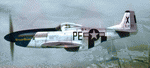
This folder contains a repaint for the A2A WoP3 P-51D Mustang, in the colors of #44-14111 PE-X "StrawBoss 2", which was flown by Col. James D Mayden of the 328 Fighter Squadron/352nd FG. Born in 1912, Mayden graduated from Kansas State College in 1935. He did his primary and advanced training in Randolph/Kelly Texas and went on to fly P-26's, P-36's, P-39's along with P-40's stateside before flying P-51's overseas.
His first kill occured on November 2nd 1944, and by the end of the war, he had 2 air victories to go with 4 ground kills. Both confirmed air kills were ME-109's. Mayden's wartime decorations included an Air Medal, Distinguished Flying Cross, and the Croix De Guerre. He also commanded the 352nd FG from July 1944 to September 1945.
The Colonel's first P-51, a B model was named "StrawBoss", a nickname said to be given to him by his dad. After a gear-up landing accident, StrawBoss was replaced with a fresh P-51D. While the left side of the new mount wore "StrawBoss 2", the right side was painted "Little Sandra", named after crew chief S/Sgt Hubert Robling's daughter.
Repaint by Jan Kees Blom, based on the A2A paintkit.
| Filename: | North_American_P51D_352nd_FG_PEX_Straw_Boss_2.zip |
| License: | Freeware |
| Added: | 25th November 2018, 00:36:08 |
| Downloads: | 56 |
| Author: | Jan Kees Blom |
| Size: | 13.22 MB |
| Category: Flight Simulator X - Aircraft Repaints, Textures and Modifications | |
| Republic P-47D-22 365th FG (D5-P) "Astra" |
|
Images related to this file:
File Description:
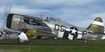
This folder contains a repaint for the A2A Wings of Power III P-47D Thunderbolt, representing P-47D-22-RE 42-6319 D5-P "Astra", the assigned aircraft of Captain George Porter of the 386th FS/365th FG as it looked in August 1944, while based at Juvincourt (A-68), France. George Porter gained the tongue in cheek title of 'flak analyst extraordinaire' after a june 1944 mission, when the 386th FS lost three aircraft to AA. During debriefing, he referred to "only moderate, and only fairly accurate flak". On 5 september 1944, he chased a Me109 to the deck, and as he closed to 500 yards, the German pilot suddenly bailed out. Porter filmed the crash and pilot on the ground and was disappointed he hadn't even fired a shot. He needed to be convinced by intelligence officers to submit a claim. He received a silver star for an action on october 12, 1944, when he encountered about 40 german fighters.Attacking four, he hit one when his aircraft, D5-P, started leaking oil over the windshield. He attacked another FW190 nonetheless, scoring hits. He later bellied in near Diest, Belgium, severly damaging Astra, but remaining unhurt himself. The tail on his aircraft was a replacement from an older aircraft, which explains the wrong serial on the tail. Repaint by Jan Kees Blom, based on the paintkit by Martin Catney.
| Filename: | Republic_P47D22_365th_FG_D5P_Astra.zip |
| License: | Freeware |
| Added: | 1st December 2019, 20:57:12 |
| Downloads: | 42 |
| Author: | Jan Kees Blom |
| Size: | 11.31 MB |
| Category: Flight Simulator 2004 - Scenery | |
| Kaltag KAL in Alaska |
|
Images related to this file:
File Description:
Kaltag is a small village on the west bank of the Yukon River, around 65 miles east of the coast at Unalakleet and about 40 miles south of where the river turns from north-south to east-west, east being upstream towards the distant Fairbanks. The population is just under 200 and living from fishing and the land. The airfield is close by and has a gravel runway aligned 21-3 and just under 5,000 feet long. Apart from the airfield itself, and it's buildings, this scenery modifies the local land class, adds village buildings while reducing the village size to reality, and creates a new airfield background. Kaltag is located on the edge of three different airlines coverage areas, and is served by Bering Air from the northwest, ERA from the southwest, and also by Wright Air from Fairbanks in the east. These are included in the AI.
A note here about my scenery making. This is post number 507 and there will not be many more to follow this as I am almost at the end of the photos I either took or found for scenery purposes. There is a limit to what can be located online and I have already been making use of the little there is; eg Unalakleet. So, if you are near an airport (preferably Canadian or Alaskan) and have a camera..... Let me know.
| Filename: | Kaltag_KAL_in_Alaska.zip |
| License: | Freeware, limited distribution |
| Added: | 20th August 2019, 19:04:35 |
| Downloads: | 101 |
| Author: | Roger Wensley |
| Size: | 3.57 MB |
| Category: Flight Simulator 2004 - Scenery | |
| Mountain View CPZ3 in Ontario, Canada |
|
Images related to this file:
File Description:
This is Mountain View, a small RCAF airfield at the eastern end of Lake Ontario on Prince Edward Island, some 40 miles west of Kingston. Mountain View is used for training during the summer months, and part of this training is for C-130 crews, who practice landing on rough or unprepared landing strips. The crews are based at Trenton, which is a large base 10 miles to the northwest on the mainland. There are (or were, I haven't seen it recently) numerous parked and ancient fighter planes such T-33's and Canadair Tutors; these could also have possibly been used for summer training or perhaps were just stored. Last summer there were only two hangars left standing; in 2002 there were five. In real life you would be on the lookout not only for C-130's but also (at certain times during the summer) for parachutists and also gliders. This airfield is one that you will fly over and not land on; I confess that I have cheated with the length of the 06L-24R gravel "practice" runway, so that it became possible for the FS version of a touch-n-go with a C-130 to be completed without using the grass. The aerial photograph shows the new "practice" gravel runway under construction.
| Filename: | Mountain_View_CPZ3_in_Ontario_Canada.zip |
| License: | Freeware, limited distribution |
| Added: | 9th March 2012, 15:05:57 |
| Downloads: | 350 |
| Author: | Roger Wensley |
| Size: | 7.26 MB |
| Category: Flight Simulator X - Scenery | |
| California Central Coast Scenery for FSX with Megascenery Earth (Default Mesh Terrain) |
|
Images related to this file:
File Description:
Revised 1/7/10 for upload to Avsim.COM. CCFSXMSFix is incorporated so not required.
This is an earlier version of CCC Megascenery Earth scenery that doesn't require FSGenesis Mesh Terrain. See CCFSXMSG.ZIP for the FSGenesis Mesh version.
This scenery covers the California coastal region from N36���°10' (Coalinga) to N34���°25' (Santa Barbara) and from the coast East to W119���°40'. It is a version of my previous California Central Coast scenery redesigned and expanded to work with MegaScenery Earth from PC Aviator Inc. Many airstrips in the area covered by this scenery have been added or enhanced for a total of 27 airports/airstrips in the area. Several areas of interest such as the Santa Barbara marina, Morro Bay, etc. are also included for a total of 41 points of interest. All airports/airstrips and related structures have been adjusted and realigned to conform to actual positions and dimensions as indicated by the MegaScenery satellite textures. In addition, there are 6 invisible water runways for use by AI floatplane traffic. MegaScenery California-13, -14 and -15 are required for this scenery to make sense. I also used California-12, -28 and -29 when constructing the scenery but they could be considered optional.
| Filename: | California_Central_Coast_Scenery_for_FSX_with_Mega.zip |
| License: | Freeware |
| Added: | 7th January 2010, 21:28:45 |
| Downloads: | 1,559 |
| Author: | Al Wheeler |
| Size: | 8.12 MB |
| Category: Flight Simulator X - AFCAD Files | |
| Wide Sky Airpark Airport (JY31), NJ |
|
File Description:
Located 03 miles NW of Bridgeton, New Jersey on 23 acres of land, Wide Sky Airpark Airport is a private turf field 2550' in length. There is no fuel available, but there is tiedown space by the main hangar in the middle of the field to the west. You can start in the parking spot there if you have a plane with 40' or less wingspan (collision with static aircraft is disabled so you can put a bigger plane there if you wish with no trouble). The windsock is not lit at night and is located atop the south end of then main hangar's roof. The field is hedged in to the east with bushes but they do not cause aircraft collisions. The runway is lit for night VFR operations. There is no hard surfaced runway so set your terrain mesh settings as high as possible to enjoy rolling around on bare bumpy terrain.
Scenery constructed with use of satellite images/streetview/aerial photos - the author has not been there in person.
This scenery is meant to be used in conjunction with MegaScenery Earth New Jersey/Delaware 004. It is not required, but apron use is minimized to allow satellite scenery to show through as much as possible, and objects are placed based on the MSE textures - lack of it may make scenery look out of place.
| Filename: | Wide_Sky_Airpark_Airport_JY31_NJ.zip |
| License: | Freeware |
| Added: | 10th May 2011, 13:40:36 |
| Downloads: | 157 |
| Author: | Drew Sikora |
| Size: | 1.27 MB |
© 2001-2026 AVSIM Online
All Rights Reserved
Privacy Policy |