
Where Flight Simulation Enthusiasts Gather from Around the World!
AVSIM Library - Search Results

| Category: Flight Simulator 2004 - Scenery | |
| Anahim Lake CAJ4 in British Columbia, Canada |

|
Images related to this file:
File Description:
Anahim Lake is around 55 miles east of Bella Coola by air, and clear of the deep and rugged valley that connects the two with a road that is over 75 miles long. The two are also linked by a daily Pacific Coastal flight. A further 150 miles east is Williams Lake (200 miles by road). The town of Anahim Lake is small, but renowned for numerous surrounding fishing lodges on the lakes and the enjoyment of "nature" in what is known as the Chilcotin Wilderness. The Anahim Lake airport is an odd one. It appears to have fallen into disuse over a period of years, but is now in the process of being upgraded, with some new hangars (though oddly situated, and with only dirt track taxiway access) and a recently completed terminal building. There is also a plan to upgrade the runway (lights etc, there are currently no runway or taxiway lights) and in general to greatly improve the facilities on offer. The only current airline to fly there is Pacific Coastal. The runway is just under 4,000 feet of asphalt aligned 13-31 and 75 feet wide. There used to be another runway which is still visible but is now unusable, gravel that has not been maintained for several years. The notes for Anahim Lake airfield in the Nav Canada manual warn of "Extensive float plane activity at Nimpo Lake to the south" and of "possible large animals within the airport perimeter". Nimpo Lake activity will follow in further posts.
| Filename: | Anahim_Lake_CAJ4_in_British_Columbia_Canada.zip |
| License: | Freeware, limited distribution |
| Added: | 29th November 2018, 19:21:59 |
| Downloads: | 153 |
| Author: | Roger Wensley |
| Size: | 5.72 MB |
| Category: Flight Simulator X - Miscellaneous Files | |
| Drivable and Flyable Grey Van |
|
Images related to this file:
File Description:
The Drivable and Flyable Grey Van is derived from a stationary Euro Van model by the following modifications / additions:
-land-vehicle instrument panel
-sound files
-FSX effects and custom exhaust smoke effects files
-modified .CFG and .AIR files
The vehicle is powered by a single aircraft piston engine with modified flaps to serve as a gear-shift. High gear allows the vehicle to speed up to 70 Kt on wide highways, while the low gear restricts the speed to about 12 Kt, but enables the vehicle to ascend steep slopes for exploring terrain scenery.
At speeds around 65-70 Kt (in gear 4), pulling back on the yoke will allow the vehicle to take off and fly at level-flight speeds around 70 Kt. This is an interesting way to go island-hopping, overcome insurmountable terrain obstacles, or cover larger straight-line distances without using the slew mode.
An autopilot with hold altitude and hold heading options is operable during flight only.
All dashboard instruments are fully functional, including the Radio-Magnetic Indicator (RMI) during flight. Needles 1 and 2 are activated if correct frequencies are entered in the ADF and VOR radios.
The vehicle has lights which are toggled by pressing [L]. Lights are associated with a very thin exhaust smoke effect. Thick exhaust smoke is toggled by pressing [I].
Driving vehicles through FSX scenery in different seasons presents a whole new aspect to the simulation. It allows us to imagine discovering innumerable places on the planet which are in practice beyond our reach.
I hope you enjoy!
| Filename: | Drivable_and_Flyable_Grey_Van.zip |
| License: | Freeware |
| Added: | 29th January 2024, 15:24:50 |
| Downloads: | 37 |
| Author: | Rudy E. Kokich |
| Size: | 38.63 MB |
| Category: Flight Simulator 2004 - Scenery | |
| Gjoa Haven CYHK, on King William Island, Nunavut, Canada, |
|
Images related to this file:
File Description:
Gjoa Haven is a village of 1,200 or so inhabitants at N 68 38 W 95 51 on the southeast corner of King William Island, around 155 miles north of the Arctic Circle. It's Inuit name is Uqsuqtuuq; the Gjoa Haven name was given by the Norwegian explorer Roald Amundsen when he spent two years there from 1903 to 1905 during his exploration of the northwest passage from east to west. His boat was called Gjoa and the cove was named Gjoa Harbour, in Norwegian. The village has been added in this scenery with approximately the right shape; though the coastline with Ultimate Terrain does have the small cove that serves as a harbor the coast shape is wrong. The airfield runway is 4,400 feet of gravel 100 feet wide at 154 feet above sea level. There is no LL100 available, only JetA1, delivered once a year by ship along with all the other requirements of the town. There is also a nearby CAM-B remotely operated defence radar station with its three protective domes. The old terminal building is still there, albeit repainted and spruced up, along with the far larger and newer one alongside it.
One of the screen shots shows Gjoa Haven as it appears for at least 8 months of the year, with snow on the ground and sea ice all around. If you want the ice then download my recent post of All Canada frozen lakes, rivers, and the northern seas, reversible with an untick in the FS scenery library.
| Filename: | Gjoa_Haven_CYHK_on_King_William_Island_Nunavut_Can.zip |
| License: | Freeware, limited distribution |
| Added: | 19th February 2011, 15:42:51 |
| Downloads: | 551 |
| Author: | Roger Wensley |
| Size: | 2.68 MB |
| Category: Flight Simulator 2004 - Scenery | |
| CNZ3 - Chatham-Kent - Ontario, Canada V1 |
|
Images related to this file:
File Description:
This is partly part of the Small Ontario Fields series. The airport ICAO was changed from CNZ3 to CYCK in November 2012; I have left it as it was. The runway too remains as it was a few years ago. Chatham is located 50 miles east of Detroit and 150 miles southwest of Toronto, between Lake St. Clair and Lake Erie, and the airfield is southeast of the town. There is a single asphalt runway 5,000 feet long and 75 feet wide, aligned 05/23 in FS9 but in fact in real life now 06/24 due to the wandering magnetic north. The apron is on the northern side of the runway at the eastern end, with added taxiways to cater for newer hangars wearing identical colour schemes. There is fuel, runway lighting, some taxiway lights, visitor parking on the grass, and plane maintenance in the large hangar beside the small terminal building on the north side of the apron. There is a train station in the middle of the town, and no scheduled flights to the airport that is 8 miles away; these two facts may be connected. Ditches along the road and around much of the airfield provide separation, which is why the fences are not continuous. If you are on the runway and find your path to the apron blocked by another plane that is stationary at the hold short, continue past the first turnoff to the threshold markers and turn off the runway and wait. The AI plane will then taxi out and you will have a clear path.
| Filename: | CNZ3__ChathamKent__Ontario_Canada_V1.zip |
| License: | Freeware, limited distribution |
| Added: | 27th August 2015, 21:02:59 |
| Downloads: | 341 |
| Author: | Roger Wensley |
| Size: | 9.89 MB |
| Category: Flight Simulator 2004 - Scenery | |
| CYQS - St Thomas - Ontario, Canada *V1* |
|
Images related to this file:
File Description:
St Thomas is a town in Ontario around 12 miles south of London and less than 10 miles from the north shore of Lake Erie, with a population of just under 40,000. The airport (actually more of an airfield, as there are no scheduled flights) has three runways typical of an ex-military field, with one remaining hangar from RCAF flight training times in the 1940's, and the east-west runway now extended to just over 5,000 feet. The main presence at CYQS is a company in the crop seeding and spraying business over a wide area of Ontario; as a result there are several AT-802 planes based there which are included here as AI planes and also as parked scenery objects. To the west of the original apron area there are added taxiways to cater for a herd of new individual hangars wearing orange and white uniforms. There is fuel, runway lighting on 09-27, taxiway lights, visitor parking on the edge of the apron, and maintenance companies in the large hangars, plus a flight training group. A small terminal building sits quietly between hangars, waiting. Ditches along the road and around much of the airfield provide separation, which is why the fences are not continuous. I presume that the warning balls on the electricity cables were found to be necessary to persuade pilots not to land there; probably ski planes in winter, they tend to land anywhere so long as it has snow on it. This V1 version includes previous updates.
| Filename: | CYQS__St_Thomas__Ontario_Canada_V1.zip |
| License: | Freeware, limited distribution |
| Added: | 30th August 2015, 02:35:28 |
| Downloads: | 265 |
| Author: | Roger Wensley |
| Size: | 11.13 MB |
| Category: Flight Simulator X - Original Aircraft | |
| UFO - A51 |
|
Images related to this file:
File Description:
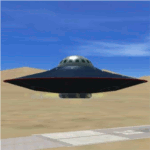
You can fly this UFO model in all directions e.g. vertical up/down lateral right/left, forward/backward, and can stay in a static position on any altitude level. The UFO provides a maximum speed of Mach 4.3 on all altitude levels and the altitude level is unlimited.
The overall radius of the model is 170 feet. The overall height is 100 feet. Be aware of this size if you are landing on standard airports. The model includes a animated gear system which is a big gray ring. The red disk on the outside of the model is the rotating UFO engine. In addition the model contains 3 guns which are moving out of the body if they are armed by activating a switch on the weapon control control panel. Important to say, the UFO is not a traditional aircraft. It reacts different and you need to handle it differently too! For more information and how to fly the model, read the documentation carefully and read the documentation first, before you go to fly it !!!!
The model and the gauges have been developed for FSX Flight Simulator SP2 or SP1. It has also been tested with Microsoft Acceleration but compatibility is not guaranteed by the author. The format for the panel and gauges is developed for a 4/3 monitor. Use the Wide Screen Panel.cfg if you have a 16/9 Monitor. For installation instructions see the documentation inside the zip file.
Credit goes out to: Bob Familton and Geoffrey Bogeaus for improvement, recommendations, testing and review, and to Doug Dawson for his XML IPC interface.
Enjoy a new way to fly.
Dietmar Loleit
| Filename: | UFO__A51.zip |
| License: | Freeware, limited distribution |
| Added: | 21st January 2014, 15:43:13 |
| Downloads: | 725 |
| Author: | Dietmar Loleit |
| Size: | 19.67 MB |
| Category: Flight Simulator 2004 - Scenery | |
| Fort Simpson Island CET4 - Northwest Territories, Canada |
|
Images related to this file:
File Description:
Fort Simpson Island is the fifth in a series of airfields that follow (approximately) in a southward direction the Mackenzie River. At the far northern end of the river there is Tuktoyaktuk, then Inuvik, Fort McPherson, Fort Good Hope, Deline, and then Wrigley, all posted. Fort Simpson Island is at 405 feet asl and on the west bank of the the Mackenzie, around 110 miles south of Wrigley at the junction of the Mackenzie and the Liard rivers. The town of Fort Simpson is on an island, and has a population of 1,250 or so folks. The Hudson Bay trading post was established here in 1822. The airport is right next to the town, and has 3,000 feet of gravel runway, though with a displaced threshold of 1,000 feet at each end (unmarked, on gravel) this is effectively 2,000 feet for landing. The Canada Flight Supplement lists the runway as being 100 feet wide; the gravel is definitely far less and the 100 refers to the width in the winter when you are landing on snow and don't care if there is gravel or grass underneath. There are no scheduled flights as these go to the nearby Fort Simpson CYFS. There is a mandatory radio frequency which is for both CYFS and CET4 and in this case I have set the "tower" to "manned" so you will report position and obey instructions. Runway 13 has right hand circuits. I have modified the Ultimate Terrain route for the Mackenzie Highway so that it remains on the west side of the river and does not wander randomly from one side to the other north of Fort Simpson.
| Filename: | Fort_Simpson_Island_CET4__Northwest_Territories_Ca.zip |
| License: | Freeware, limited distribution |
| Added: | 6th July 2014, 02:56:05 |
| Downloads: | 208 |
| Author: | Roger Wensley |
| Size: | 2.46 MB |
| Category: Flight Simulator X - Aircraft Repaints, Textures and Modifications | |
| Boeing B-52H CONECT |
|
File Description:
In July 2013, the Air Force began a fleet-wide technological upgrade of its B-52 bombers called Combat Network Communications Technology (CONECT) to modernize electronics, communications technology, computing, instrumentation, and avionics on the flight deck. CONECT upgrades include software and hardware such as new servers, modems, radios, data-links, receivers, digital flight deck and workstations for the crew. Making the B-52 compatible with 21st century flight and combat roles.
Items reworked for FSX/P3D:
1. True FSX Native modeling, converted to FSX using ARNO'€™s MDLX program.
2. All new paints.
3. New blank bump mapping
4. All paints are in DDS format.
5. Multiple Liveries.
6. New air configuration file.
7. New HD VC textures.
8. FSX Air File installed.
9. Camera views added.
10. Transparency issue with VC model addressed.
11. All new digital cockpit created.
12. FSX coded gauges and sub panels.
13. Default and custom GPS.
14. Working Traffic Radar.
There are multiple popup windows that can be activated with-in the VC, they include the following. A full sized Horizontal Situational Indicator. A full sized Attitude Indicator. A full sized custom GPS. A full sized Radar Screen. Icon controlled Radio popup. Icon controlled over head electrical engine start panel. Icon controlled Throttle Panel. Icon controlled default GPS, Icon controlled Map, Icon controlled ATC, Mouseable Autopilot, Mouseable Flaps, Mouseable Landing Gears, Mouseable Warning lamps.
Video available here: https://www.youtube.com/watch?v=M2ii2uxSbNA
Based on the Alphasim freeware B-52 model.
| Filename: | Boeing_B52H_CONECT.zip |
| License: | Freeware |
| Added: | 3rd January 2016, 12:54:03 |
| Downloads: | 420 |
| Author: | David Robles |
| Size: | 36.28 MB |
| Category: Orbiter - Miscellaneous Files | |
| Gusev Crater Scenery |
|
File Description:
Gusev Crater is an impact crater on Mars that looks as though a lake may have once filled it in the distant past.
Gusev Crater is about 145 km (90 miles) wide. It is located at 14.6° South latitude and 175.3° East longitude, along the boundary between Mars' southern highlands and its lowland northern plains. The crater is about 3,000 km (1,900 miles) southeast of the volcano Elysium Mons. Scientists believe the Gusev Crater was formed by the impact of an asteroid three to four billion years ago.
A valley named Ma'adim Vallis, which is connected to the south side of the crater, looks like it may have been a river channel that poured water into the crater in the past, forming a large lake. If the crater was indeed a lake, scientists expect it to contain layers of sediments as much as 915 meters (3,000 feet) thick that flowed in with the water. There may be other clues to a watery past within the crater, such as deposits of minerals, such as halite and gypsum, that form when water evaporates. Wet environments are the best places to look for life, which is why scientists are so eager to track down places on Mars that were once wet.
On the 3rd of January 2004, MER-A Spirit, one of the two Mars Exploration Rovers (MER) had landed within an 81 km by 12 km (50 by 7 miles) oval near the center of Gusev Crater. Once settled into its new "home", Spirit will begin its mission of exploring for geologic evidence of the presence of water in Gusev Crater's past.
| Filename: | Gusev_Crater_Scenery.zip |
| License: | Freeware |
| Added: | 5th January 2004, 17:56:22 |
| Downloads: | 1,376 |
| Author: | Robert Stettner (Foxtrot) |
| Size: | 378.72 KB |
| Category: Flight Simulator 2004 - Scenery | |
| Beaver Creek CYXQ in Yukon Territory, Canada |
|
Images related to this file:
File Description:
Beaver Creek is located at mile 1202 of the Alaska Highway, just east of the Alaska/Yukon border. The populaton is around 100 and the main employment is with the Border Agency, the White River First Nation, or with local tourist lodges. The airfield is a mile north of the town and close to the Canadian border post, which is included in the scenery. It was built by Jack Stalberg in the 1960's, and I have no further information beyond the fact that he loved to fly. The airport serves as an "airport of entry", though it is restricted in hours of opening and in the size of aircraft that it can handle; up to a maximum of only 15 seats. The single runway is 3,745 feet long and 100 feet wide, gravel, aligned 13-31 in FS9, lit, and with vasi at both ends. Righthand circuits for runway 13. There is a 340 feet threshold displacement to runway 31, which is of course unmarked on a gravel runway. The terminal building was recently reclad; I don't like it, but they didn't consult me. The ai reflects the sort of traffic the airfield gets; ie brief paperwork stopovers for GA or small charter flights into Canada from Alaska, usually in the mornings.I have adjusted the local scenery terrain levels to remove adjacent hills that I believe do not exist in real life but are part of the Northern Canada terrain mesh that I have installed. If you do not have this mesh you may find that the scenery works fine for you without the API flatten that is included here. The airfield is at 2,129 feet ASL.
| Filename: | Beaver_Creek_CYXQ_in_Yukon_Territory_Canada.zip |
| License: | Freeware, limited distribution |
| Added: | 28th January 2019, 06:19:20 |
| Downloads: | 175 |
| Author: | Roger Wensley |
| Size: | 4.68 MB |


© 2001-2026 AVSIM Online
All Rights Reserved
Privacy Policy |