
Where Flight Simulation Enthusiasts Gather from Around the World!
AVSIM Library - Search Results

| Category: Flight Simulator 2004 - Scenery | |
| Forggensee, v2 part 2 |

|
Images related to this file:
File Description:
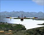
This AI-Package contains several pretty nice AI-Airplanes: Grumman-Albatross HU16,
Grumman-Goose G21, Dornier Do-24K, Junkers Ju-52 and a Bell-47G2 Helicopter on
floats , performing "Touch and Goes" on Water-Runway 21 as well as various beautiful
AI-Boats and two good looking female windsurfer cruising back and force at the lake.
All the attached outstanding AI-Objects have been created by well known designers
(see briefing below). My part was just to prepare them to work with the improved
Forggensee Scenery V2 Part 1.
There is some amazing traffic on the lake, have a look and have fun!
| Filename: | Forggensee_v2_part_2.zip |
| License: | Freeware |
| Added: | 14th April 2011, 02:26:52 |
| Downloads: | 866 |
| Author: | Klaus Jone |
| Size: | 11.12 MB |
| Category: Flight Simulator X - Scenery | |
| Jastarnia Scenery (EPJA) |
|
File Description:
Sim Hangar team presents Jastarnia scenery. Jastarnia (EPJA) is small, private aerodrome located at Hel Penisula in Poland. Its operated mostly in Summer and offers sightseeing tours around Puck Bay and Hel area. The scenery was built using SbuilderX, Whisplacer 0.9, ADE and Autogen Annotator. Every 3D object comes from FSX object library. The scenery contains seasonal and night textures plus additional, fictional water runway. Its compatible with Vector Europe and UTX: Europe. If you don't have any of those great add-ons, I have included some small scenery which will improve Polish coastlines in your FSX. Blue Skies!
| Filename: | Jastarnia_Scenery_EPJA.zip |
| License: | Freeware, limited distribution |
| Added: | 19th May 2008, 23:12:02 |
| Downloads: | 4,959 |
| Author: | Lukasz Kubacki |
| Size: | 25.57 MB |
| Category: Prepar3D V1-4 - Scenery | |
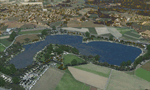
| Como Italy N45°48'36.9 "E9°05'10.1" |
|
Images related to this file:
File Description:
Como Italy N45°48'36.9 "E9°05'10.1" This marvelous city is located on the southern end of the western branch of Lake Como, in a small basin surrounded by wooded hills about 40 km from Milan. The famous tourist resort has a water-jet operating with icao LILY from which it is possible to take off with a floatplane for a sightseeing tour on Lake Como to admire the beautiful lakefront villas. Important VFR point for approaching airport Milano Linate.
Within the downloaded package you will find readme files for scenery installation. Good fly VFR. Pasquale Marrulli.
| Filename: | Como_Italy_N4548369_E905101.zip |
| License: | Freeware |
| Added: | 16th December 2017, 17:25:36 |
| Downloads: | 348 |
| Author: | Pasquale Marrulli |
| Size: | 6.16 KB |
| Category: Flight Simulator X - Scenery | |
| Pichlingersee - LOW1 |
|
Images related to this file:
File Description:
The Pichlingersee (LOW1) is a quarry pond near Linz (LOWL) in Austria (Upperaustria). The ILS approach to the runway 27 cross this lake. The helipad is in possession of Water Rescue Department and was not build on land. It was build "in water".
For the implementation of this area about 500 objects were set by hand from myself. Including not only trees and shrubs, but also signs, park benches, emergency call boxes (gernerated in gmax) etc at there right place. At night it was dark in real, so I does not create night texture. The scenery has 1.5 km ground imagery at 20cm per pixel and vary (hope) with the seasons.
Der Pichlingersee ist ein Baggersee in der Nhe von Linz (LOWL) in sterreich (Obersterreich). Der ILS Anflug auf die Landebahn 27 fhrt genau ber diesen See. Die Hubschrauberplattform gehrt der dortigen Wasserrettung und wurde nicht auf dem Land, sondern in den See hinein gebaut.
Fr die Umsetzung des Areals wurden von mir ber 500 Objekte von Hand gesetzt. Darunter nicht nur Bume und Strucher, sondern ebenso Schilder, Parkbnke, Notrufsulen (in gmax generiert) usw. an ihrem richtigen Platz. Da es dort in der Realitt nachts stockdunkel ist, habe ich auf Nachttexturen verzichtet. Die Szenerie hat eine 1.5 km Bodentextur mit 20cm/px und wechselt (hoffentlich) mit den Jahreszeiten.
| Filename: | Pichlingersee__LOW1.zip |
| License: | Freeware |
| Added: | 9th January 2013, 00:44:19 |
| Downloads: | 1,997 |
| Author: | Oliver Brandl |
| Size: | 54.71 MB |
| Category: Flight Simulator 2004 - Miscellaneous Files | |
| Nick's Prop Dust with Control Gauges |
|
File Description:
Prop aircraft users are in for a real treat. This gauge/effects package automatically senses the terrain the aircraft is in contact with or flying over and changes the dust and water effects for the aircrafts prop/rotor wash based on dirt, dry mud or clay, snow, rain, water, ice, sand, gravel and short grass. In addition the real time surface conditions are also sensed. In example, a dry asphalt or concrete runway will produce no dust, however, the same runway with snow conditions present will automatically produce a throttle controlled snow blowing effect. The 25 included effects files and 5 gauges have been tuned to reflect a realistic representation of the dust/mist produced by different types of aircraft taking off or touching down on different terrains and surface conditions. The effects are properly influenced by cross wind conditions and reverse pitch is also supported. Effects files and gauges are included for large and small, single engine, multi-engine, amphibians, helicopters and massive scale military and commercial transports. It requires editing/adding lines in the aircraft.cfg and panel.cfg files. The README files include very complete and comprehensive instructions including a quick and easy copy/paste file for all the Microsoft prop aircraft and tutorial on making custom gauges from the ones provided.
By Nick Needham
| Filename: | Nicks_Prop_Dust_with_Control_Gauges.zip |
| License: | Freeware |
| Added: | 8th December 2003, 17:07:07 |
| Downloads: | 7,298 |
| Author: | Nick Needham |
| Size: | 1.22 MB |
| Category: Flight Simulator 2004 - Scenery | |
| Valdez Pioneer Field PAVD in Alaska |
|
Images related to this file:
File Description:
Pioneer Field is in Valdez Alaska, between the mountains to the north and the water of Valdez Arm to the south. It used to cater for a lot of the work for the Alaskan pipline and the nearby terminal and in the middle 1970's it was a very busy place. That is not the case now, and the tower is no longer manned though there is still an average of 35 flights a day and there are 30 planes (and helicopters) based at the field. There are three really odd hangars at the western end of the apron, with each of them having 6 "T" hangars which have been joined in a circle; this is the only place I have ever seen this. The recently resurfaced runway is 6,500 feet of 150 feet wide asphalt aligned 6/24 at 121 feet asl. There is also a wide and heavy duty asphalt and gravel surrounding runoff and base, probably because of drainage problems with water from the mountains. Fuel (both JetA and 100LL) is available from ERA Helicopters at the eastern end of the apron. All of the buildings on the field have been modelled specifically for this scenery, plus the nearby accomodation blocks. The AI flights are for the twice-daily ERA/Alaska Air flights using a Bombardier Dash 8-200.
| Filename: | Valdez_Pioneer_Field_PAVD_in_Alaska.zip |
| License: | Freeware, limited distribution |
| Added: | 21st January 2011, 03:29:51 |
| Downloads: | 1,198 |
| Author: | Roger Wensley |
| Size: | 3.97 MB |
| Category: Prepar3D V1-4 - Utilities | |
| FSTrampFree v7.26 for Prepart3D, FSX(-SE), X-Plane 11 (Win) |
|
Images related to this file:
File Description:
The FSTrampFree addon is a decoupling from the commercial product FSTramp. It shows a 3D world map and the real time moving AI or online aircraft. Due to the integration in the simulator, the map can also be used very well with just one display. Via the context menu of the world map, the aircraft can be moved to any runways or gates. With pressed Ctrl key even to every point on the ground or on the water. During the flight, jumps to other points in the air or on the ground are possible. The AIRAC data can be updated via an additional purchase from Navigraph.
| Filename: | FSTrampFree_v726_for_Prepart3D_FSXSE_XPlane_11_Win.zip |
| License: | Freeware |
| Added: | 27th June 2019, 04:11:25 |
| Downloads: | 1,967 |
| Author: | Helge Schroeder |
| Size: | 347.67 MB |
| Category: Flight Simulator 2002 - Flight Plans | |
| Historic: Flight 19, the 'Lost Patrol' |
|
File Description:
December 5th 1945: The war in the Pacific made the topography of the Bahamas with its unlimited landmarks, ideal for advanced over water navigation exercises. Like all others training daily out of Fort Lauderdale, Florida, Flight 19 was to perform a fairly simple navigation problem. At 14:10 that afternoon 5 Avenger Torpedo Bombers departed the Station and never made it back. File includes aircraft (CFS2 default AI Avenger converted for Fs2002 and packaged to fit the flight), flight weather(local-global) based on descriptions and map of navigation problem No1 available to pilot at all times from panel via SWIFT+3. By the Fs-Icarus Crew.
| Filename: | Historic_Flight_19_the_Lost_Patrol.zip |
| License: | Freeware |
| Added: | 27th October 2002, 18:25:17 |
| Downloads: | 894 |
| Author: | Fs-Icarus Crew |
| Size: | 1.59 MB |
| Category: Flight Simulator 2002 - Scenery Design | |
| Fuel Barge |
|
File Description:
Fuel Barge. This is actually inspired from an Email I got from Curt Jardey who described this barge and well I hope it is somewhat close anyway ;-). It's a fuel Island of sorts that sits out in the water a bit so you can pull up from all directions to fuel. There is an Avgas and Jp fuel pump with retractable hose's at opposite ends of the barge. It lights at night. Curt kind of figured it was fed thru an underground line for the fuel and electricity. He has actually seen these fuel barges before. Hey, See what you can do with it!
| Filename: | Fuel_Barge.zip |
| License: | Freeware |
| Added: | 3rd December 2002, 01:38:34 |
| Downloads: | 465 |
| Author: | Frank Betts |
| Size: | 218.21 KB |
| Category: Orbiter - Miscellaneous Files | |
| Mars Atmosphere Enhancement for Orbiter |
|
File Description:
This is a cloud texture and new Mars.Cfg (must be renamed) to give Mars dynamic clouds. While Mars does not have any water for clouds, it is known that severe dust storms on the planet can send dust into the atmosphere for days. The original Mars in Orbiter does not have any dust clouds, but this enhancement simulates the dust in the atmosphere. Since they are dynamic, you can have clear skys one day, and a dust cloud passing overhead the next.
When you land or launch from Mars, you now get the feeling that you are passing through an "atmosphere". It's a pretty neat view.
| Filename: | Mars_Atmosphere_Enhancement_for_Orbiter.zip |
| License: | Freeware |
| Added: | 3rd April 2003, 01:13:56 |
| Downloads: | 1,525 |
| Author: | Jim Williams |
| Size: | 1.11 MB |
© 2001-2026 AVSIM Online
All Rights Reserved
Privacy Policy |