
Where Flight Simulation Enthusiasts Gather from Around the World!
AVSIM Library - Search Results

| Category: Flight Simulator 2004 - Scenery | |
| Columbus Stainless Steel Factory and Airfield, Middelburg, South Africa |

|
Images related to this file:
File Description:
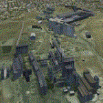
A custom made Columbus Stainless-steel Factory and its airfield, Middelburg Mall and Afgri Silo's in the town of Middelburg. The airfield is not in use anymore in real life, but this package will bring it back to life in the simulator. The Columbus stainless-steel factory is the biggest stainless-steel factory on the African continent and is situated south of the town of Middelburg, right off the N4 highway. Co-incedentally, it is also adjacent to the site of the original Middelburg airfield (included in this package) and east of the suburb of Aerorand (named as such because of the location of the original airfield right next to it) which is also where the newly built Middelburg Mall is located.
This is a nice addition to my Middelburg (FAMB) scenery (worx50.zip).
| Filename: | Columbus_Stainless_Steel_Factory_and_Airfield_Midd.zip |
| License: | Freeware, limited distribution |
| Added: | 16th February 2021, 20:01:38 |
| Downloads: | 181 |
| Author: | Kobus van Wyk & Morne van Wyk |
| Size: | 14.12 MB |
| Category: Flight Simulator 2004 - AI Flight Plans | |
| Everts Air Alaska - Summer 2010 |
|
Images related to this file:
File Description:

Everts Air Alaska is a privately held corporation including sister companys Everts Air Cargo and Everts Air Fuel. Based in Fairbanks, Everts is the last operator of the venerable Douglas DC6/C118 and provides services throughout the interior of Alaska. In addition, Everts operates at least two Curtis C46s in daily operations. Everts has purchased all available DC6s, C118s, and C119s to use as parts for the DC6s. With the supply of spares, Everts figures that the DC6s will be in operation until 2015. Flights taken from FlightAware for the week of 25-31 July, 2010, and includes all flights. Everts also recently purchased three DC9-33Fs from ABX to use in their operations. Though, these aircraft have yet to enter service, N932AX has been painted in full Everts livery.
| Filename: | Everts_Air_Alaska__Summer_2010.zip |
| License: | Freeware |
| Added: | 7th August 2010, 22:10:09 |
| Downloads: | 1,779 |
| Author: | Steve Lewis |
| Size: | 197.5 KB |
| Category: Flight Simulator X - AFCAD Files | |
| ZSHC - Hangzhou Xiaoshan Intl - Hangzhou, China |
|
Images related to this file:
File Description:
Hangzhou Xiaoshan International Airport is the principal airport serving Hangzhou, a major city in the Yangtze River Delta region and the capital of Zhejiang Province, China. The airport is located on the southern shore of Qiantang River in Xiaoshan District and is 27 km east of downtown Hangzhou. Hangzhou is a focus city for Air China, China Southern Airlines and Xiamen Airlines. In 2010, Hangzhou airport handled 17,068,585 passengers and became the 9th busiest airport in China. In addition, the airport was the country's 8th busiest airport in terms of cargo traffic and the 10th busiest airport by traffic movements. From Europe, KLM makes direct flights. Using ADEx 1.55, aeronautical maps and Google Earth the default AFCAD has been updated to reflect today's situation. Please read the Readme file for proper installation.
| Filename: | ZSHC__Hangzhou_Xiaoshan_Intl__Hangzhou_China.zip |
| License: | Freeware |
| Added: | 2nd May 2013, 13:52:13 |
| Downloads: | 1,090 |
| Author: | Menno C. Robert |
| Size: | 722.68 KB |
| Category: Prepar3D V1-4 - Scenery | |
| LTFE - Milas Bodrum Airport - Turkey |
|
Images related to this file:
File Description:
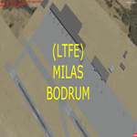
LTFE - Accurate positioning according to the latest charts, google map coordinates and the Navigraph runway coordinates data.
Upon planning a flight from Istanbul to Bodrum, I realized that the airport has been developed with the addition of the international terminal, and the conversion of the old taxiway A into a runway (10R - 28L), and thus decided to quickly make this update.
Milas–Bodrum Airport (IATA: BJV, ICAO: LTFE) is an international airport that serves the Turkish towns of Bodrum and Milas. The airport is situated 36 km northeast of the town of Bodrum, and 16 km south of Milas.
The airport is surrounded by beautiful scenery of hills, with a steep approach of 3.90 degrees due to the surrounding terrain.
Please read the included README file for the simple install instructions.
| Filename: | LTFE__Milas_Bodrum_Airport__Turkey.zip |
| License: | Freeware, limited distribution |
| Added: | 5th July 2017, 17:46:12 |
| Downloads: | 769 |
| Author: | Ahmed Abdessalam |
| Size: | 945.88 KB |
| Category: Prepar3D V1-4 - Utilities | |
| FS Flight Builder |
|
Images related to this file:
File Description:
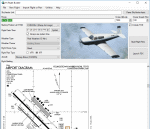
FS Flight Builder is a utility for general aviation flying that will build flight files for FSX (flt), FSX Steam Edition (flt), and Prepar3D (fxml) based on waypoints and other data either entered manually or imported from SkyVector using the Plain Text Link information. Among other things, you can select your starting position, aircraft, and a VFR or IFR flight plan.
One of the most interesting features of the application is that it will include a Briefing file, added to the aircraft's built-in kneedboard, that will include departure and destination airport information (runways, frequencies, weather, and charts) as well as navigation frequencies along the route.
Included is a new destination chooser function that allows you to enter your departure airport and additional criteria, such as min and max distance, tower required, ILS, runway length restrictions.
| Filename: | FS_Flight_Builder.zip |
| License: | Freeware |
| Added: | 30th July 2018, 03:56:07 |
| Downloads: | 148 |
| Author: | Tom Arduini |
| Size: | 28.24 MB |
| Category: Flight Simulator X - Flight Plans | |
| Current Low Altitude Military Training Route for the US Territories of Guam and Puetro Rico |
|
Images related to this file:
File Description:
FSX Flight Plans for current low altitude military training route for the US Territories of Guam and Puetro Rico. This package includes 9 individual flight plans for IFR, VFR and Slow Speed Routes. These are great routes for B-52, F-111, B-1B, B-2 A6, A4, Vulcan and any fighter or bomber enthusiasts. Of course you can fly the route with any aircraft of your choice. Also included in this package are two spectacular gauges by Karol Chlebowski for TFR flying and Pave Tack which includes many advanced features for bombing, navigation and reconnaissance. These two gauges will greatly enhance your ability to fly these challenging routes and are a great companion of the flight plans. Another option is to download Version 2.1 of my mini panel which has all this functionality and more.
| Filename: | Current_Low_Altitude_Military_Training_Route_for_t.zip |
| License: | Freeware |
| Added: | 16th September 2011, 14:17:26 |
| Downloads: | 467 |
| Author: | Bill McClellan |
| Size: | 1.56 MB |
| Category: Flight Simulator 2002 - Flight Plans | |
| 53RTWest |
|
File Description:
An FS2002 GPS flight Plan by the Ancient Brit. The 53rd in a series of Round the World flight plans for the FS2002 default scenery. Depart Kulusuk (BGKK) runway 11, Greenland and arrive 2 hours 9 minutes later at Kangerlussuaq (BGSF) runway 10 Greenland. The direct distance is 337 nm, but I have gone the ‘pretty way’ taking 621 nm and using 1,340 custom waypoints in the process. The departure takes you for a low level tour (500 ft) along Fjords and between mountains, climbs to cruise then descends for another low level tour (500 ft) along Fjords and between mountains, before finishing with a VFR landing (Hand holding instructions given). The flight briefing (Word and text) is for the default B737-400; it contains climb, cruise, top of descent and fuel loading details, waypoint timings and destination details.
| Filename: | 53RTWest.zip |
| License: | Freeware |
| Added: | 22nd March 2003, 10:47:54 |
| Downloads: | 556 |
| Author: | Denis Egan |
| Size: | 33.07 KB |
| Category: Flight Simulator 2004 - Miscellaneous Files | |
| Emma Field Sightseeing Tour Release II |
|
File Description:
Fly a VFR-tour in the area east of Seattle, Washington. You will need some skills of
bush-flying. Included in this package are a detailed tour-description, maps (one per stage), situation- and WX-files (also per stage).
You will leave from Emma Field and visit the following airfields: Elma (4W8), Flying M Ranch (OR05), Mount St. Helens Aero Ranch (WN10), Sultan Field (39P), Packwood (55S), Ranger Creek (21W), Cashmere-Dryden (8S2), Chelan (6S9),Stehekin State (1S2), Twisp Muni (2S0), Darrington Muni (1S2), Sky Harbor (S86), Harvey Field (S43), Diamond Point(2WA1), Lost Valley (KLVY), Forks (S18) and Washabamaggie Lake, before you return to Emma Field.
This tour is based on the products Emma Field, GeoRender 1, GeoRender 3, GeoRender 4, GeoRender 5 and GeoRender 6 (all Lago) and freely downloadable scenery, but can also be flown without (one of) these.
Enjoy.
| Filename: | Emma_Field_Sightseeing_Tour_Release_II.zip |
| License: | Freeware |
| Added: | 18th December 2003, 23:37:29 |
| Downloads: | 2,238 |
| Author: | J. van Hees |
| Size: | 5.07 MB |
| Category: Flight Simulator 2004 - Scenery | |
| Fronconia NH 1B5 |
|
File Description:
This is my first attempt at making any kind of scenery for Flight Simulator. I live in Boston and love getting up into the White Mountains both in Summer and in Winter, so I decided to use my ultimate power of MSFS Eminent Domain and evicted the owners of this small private field right in the heart of the Presidential Range in order to create a fictionalized Pilot's home. It's nothing fancy, but it is a nice base for VFR flights throughout the region. We don't have the drastic vertical topography as many other places around the world here in New England, but I guarantee you that we have some of the prettiest, especially in the fall.
I hope you enjoy, and if you have any problems please e-mail me at [email protected]
Thanks,
John Combs
| Filename: | Fronconia_NH_1B5.zip |
| License: | Freeware |
| Added: | 28th June 2004, 16:05:56 |
| Downloads: | 489 |
| Author: | John Combs |
| Size: | 175.3 KB |
| Category: Flight Simulator 2004 - Miscellaneous Files | |
| Emma Field Sightseeing Tour Release III |
|
File Description:
Fly a VFR-tour in the area around Seattle, Washington. You will need some skills of bush-flying. Included in this package are a detailed tour-description, maps (one per stage), situation- and WX-files (also per stage). You will leave from Emma Field (KEWL) and visit the following airfields: Forks (S18), Sekiu (11S), Sequim Valley (W28), Orcas Island (KORS), Lynden (38W), Israels Farm (WA56), Stehekin State (6S9), Lake Wenatchee State (27W), Skykomish State (S88), Sky Harbor (S86), Bandera State (4W0), Easton State (KESW), Trout Lake (66WA), Mt.St.Helens Aero Ranch (WN10), Seaside Muni (56S), Westport (14S) and Cricket Field (4WA2), before you return to Emma Field.
This tour is based on the products Emma Field (Lago), GeoRender 5 (Lago), GeoRender 6 (Lago) and Orcas Island (FSAddon), but can also be flown without (one of) these. Enjoy.
| Filename: | Emma_Field_Sightseeing_Tour_Release_III.zip |
| License: | Freeware |
| Added: | 30th July 2004, 16:21:08 |
| Downloads: | 1,686 |
| Author: | Jaap van Hees |
| Size: | 5.84 MB |


© 2001-2026 AVSIM Online
All Rights Reserved
Privacy Policy |