
Where Flight Simulation Enthusiasts Gather from Around the World!
AVSIM Library - Search Results

| Category: Flight Simulator X - Scenery | |
| Rabigh Airport OERB Saudi Arabia |

|
Images related to this file:
File Description:
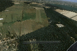
Rabigh Airport OERB Saudi Arabia fsx scenery project , add Hangar building 1 apron for 4 light aircrafts , airport used for VFR and flight school only The airport updated to reflect current satellite imagery and positioning ,
it should work for p3d
| Filename: | Rabigh_Airport_OERB_Saudi_Arabia.zip |
| License: | Freeware |
| Added: | 2nd January 2019, 23:20:47 |
| Downloads: | 260 |
| Author: | Mohamed Salamoni |
| Size: | 1.3 MB |
| Category: Flight Simulator 2004 - Scenery | |
| Friedersdorf EDCF v1.0 |
|
Images related to this file:
File Description:
This is a project I made. It's the little Airfield Friedersdorf (EDCF) near Berlin the capital of Germany. This scenery contains Photoreal Scenery but it's also compatible with VFR Germany and co. Read the readme for more info about this.
| Filename: | Friedersdorf_EDCF_v10.zip |
| License: | Freeware |
| Added: | 25th March 2011, 22:40:06 |
| Downloads: | 608 |
| Author: | Nico Gruenberger (nejiplayer) |
| Size: | 19.83 MB |
| Category: Flight Simulator X - Scenery | |
| Gokceada, Imroz (LT86) - Turkey |
|
File Description:
Photoreal scenery of Gokceada Imroz with 2m texture resolution. Gokceada is the far-west point of Turkey in Aegean Sea which makes it a very good VFR base reaching Marmara, Gallipoli, Dardanels, Canakkale, Bosphorous, Istanbul, Trakia and wonderful Greek Islands.
| Filename: | Gokceada_Imroz_LT86__Turkey.zip |
| License: | Freeware, limited distribution |
| Added: | 12th April 2010, 19:23:50 |
| Downloads: | 2,717 |
| Author: | Ahmet Mehmetbeyoglu |
| Size: | 61.65 MB |
| Category: Flight Simulator X - Scenery | |
| Fishing boat for FSX |
|
Images related to this file:
File Description:
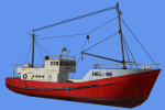
FSX AI Fishing boat Traffic V1. This package than 8 AI Fishing boat and AI ship traffic routes
for the Baltic Sea for FSX.
Fishing boat route for default FSX and for VFR Poland Region NW version. By Robert Jastrzebski.
| Filename: | Fishing_boat_for_FSX.zip |
| License: | Freeware |
| Added: | 21st June 2017, 04:44:52 |
| Downloads: | 416 |
| Author: | Robert Jastrzębski (RCJ) |
| Size: | 12.12 MB |
| Category: Flight Simulator 2004 - Scenery Design | |
| RAF Cranwell Part 1 |
|
File Description:
This is the first part of a fully detailed RAF Cranwell Scenery. I have concentrated
mainly around the South West of the Airfield as that is where the main aircraft ramp is. The Scenery is aligned with the UK VFR Photoscenery.
| Filename: | RAF_Cranwell_Part_1.zip |
| License: | Freeware, limited distribution |
| Added: | 1st May 2006, 23:40:45 |
| Downloads: | 1,273 |
| Author: | Keith Steadman |
| Size: | 6.96 MB |
| Category: Flight Simulator X - Scenery | |
| Polish Airports Photo Scenery Vol.2 - Mazury Airports |
|
File Description:
The second Vol. of my VFR Photo Sceneries. In this volume we've got EPOD-Olsztyn, EPKI-Kikity, EPMG-Mragowo, EPBB-Babieta, EPSU-Suwalki and EPBK-Bialystok (If you downloaded vol.1 please delete it, new EPBK Scenery is in this vol.)
| Filename: | Polish_Airports_Photo_Scenery_Vol2__Mazury_Airport.zip |
| License: | Freeware, limited distribution |
| Added: | 28th October 2013, 20:28:56 |
| Downloads: | 2,067 |
| Author: | Mikolaj Dudko |
| Size: | 72.63 MB |
| Category: Prepar3D V1-4 - Scenery | |
| Ariano Irpino Campania Italy N41 ° 08'59 "E15 ° 05'03" |
|
File Description:
Ariano Irpino Campania Italy N41 ° 08'59 "E15 ° 05'03" is a small town in the Campania Apennine, almost on horseback between the Campania and Puglia regions and in an almost equidistant position between the Tyrrhenian and Adriatic seas, so that the watershed crosses for dozens of kilometers the municipal agritours in the center of which is located an important Apennine valley, the Sella di Ariano. The altitude varies from 179 to 811 m. S.l.m. Important VFR point for approaching Foggia, or Naples, Avellino and Benevento..
Within the downloaded package you will find readme files for scenery installation. Good fly VFR. Pasquale Marrulli.
| Filename: | Ariano_Irpino_Campania_Italy_N41__0859_E15__0503.zip |
| License: | Freeware |
| Added: | 23rd October 2017, 14:45:12 |
| Downloads: | 408 |
| Author: | Pasquale Marrulli |
| Size: | 1.31 KB |
| Category: Prepar3D V1-4 - Scenery | |
| Porto Cervo Sardegna Italy N41.07.59 E9.31.50 |
|
Images related to this file:
File Description:
Porto Cervo Sardinea Italy N41.07.59 E9.31.50 Famous center of the Costa Smeralda has a wonderful natural harbor highlighted in the 60's by Prince Karim Aga Khan IV, fascinated by the beauty of this stretch of coastline. The name Porto Cervo dates back to the shape of the horn-shaped harbor. The destination of the summer movida is visited by many tourists. In its pore there is also a seaplane berth. Important VFR point for approaching airport Olbia Costa Smeralda ILEO.
Within the downloaded package you will find readme files for scenery installation. Good fly VFR. Pasquale Marrulli.
| Filename: | Porto_Cervo_Sardegna_Italy_N410759_E93150.zip |
| License: | Freeware |
| Added: | 19th November 2017, 22:02:38 |
| Downloads: | 226 |
| Author: | Pasquale Marrulli |
| Size: | 1.99 KB |
| Category: Flight Simulator 2002 - Scenery | |
| Cornish Windfarms |
|
File Description:
This freeware demo is part of Nick Ryall SW England Landmark Scenery available from http://www.visualflight.co.uk/nickryall.
This scenery represents 7 Cornish windfarms in Cornwall UK, Goonhilly downs, Four Burrows, Carland cross,
Bears down, St Breock downs, Delabole and Cold Nortcott
The scenery has been designed primarily for use with addon VFR photographic scenery from Visual Flight and mesh terrain Lago's Terramesh for the UK.
It is part of a package which contains more than 50 VFR scenery Landmarks for the SW UK and is available for purchase at the Visual Flight website It does however work with Microsoft's default mesh terrain.
| Filename: | Cornish_Windfarms.zip |
| License: | Freeware |
| Added: | 10th March 2003, 16:12:55 |
| Downloads: | 1,668 |
| Author: | Nick Ryall |
| Size: | 2.28 MB |
| Category: Flight Simulator 2002 - Flight Plans | |
| 50RTWest |
|
File Description:
An FS2002 GPS flight Plan by the Ancient Brit. The 50th in a series of Round the World flight plans for the FS2002 default scenery. Depart Stornoway (EGPO) runway 36, Scotland and arrive 47 minutes later at Vagar (EKVG) The Faroes Islands. Vagar, a small airport but rated for B737’s. The offset ILS is ignored in this plan and a VFR finals is used. Full hand holding details for the VFR finals are given. The flight briefing (Word and text) is for the default B737-400; it contains climb, cruise, top of descent and fuel loading details, waypoint timings and destination details.
| Filename: | 50RTWest.zip |
| License: | Freeware |
| Added: | 2nd March 2003, 20:46:57 |
| Downloads: | 655 |
| Author: | Denis Egan |
| Size: | 17.81 KB |
© 2001-2026 AVSIM Online
All Rights Reserved
Privacy Policy |