
Where Flight Simulation Enthusiasts Gather from Around the World!
AVSIM Library - Search Results

| Category: Flight Simulator 2004 - Original Aircraft | |
| Skydiver |

|
File Description:
This Skydiver will free fall in FS9 under your control. Start him at 20,000 ft and let him free fall to about 6,000 ft before selecting the Parafoil (available as a separate download)for the remainder of your jump. You control his arms and legs to get the best glide after turning him on the right course. He is reasonably stable but control may take practice. The basic body was supplied as an example by Abacus with FS Design Studio Pro. I broke his knees, animated the arms and legs and wrote the FD files. Startup conditions are included. A checklist tells how to control him. Tom Goodrick.
| Filename: | Skydiver.zip |
| License: | Freeware, limited distribution |
| Added: | 1st June 2004, 22:35:42 |
| Downloads: | 3,457 |
| Author: | Tom Goodrick |
| Size: | 4.33 MB |
| Category: Flight Simulator 2004 - Panels | |
| POSKY 747-200 Alternate Wing And Engine Views |
|
File Description:
This big bird of the sky is one of the worlds best selling boeing aircraft, most people I know love flying this ledgend as do I. Some of them also enjoy taking in the passenger perspective, these wing views enable you to do this, the left side is a few rows behind the wing and the right side is a few rows infront of the wing. I made these views with reference to real photos, hopefully I have them right!! I have never been in a 747 but why not take it for a spin and check it out for yourself!!
Please check Readme for install instructions.
| Filename: | POSKY_747200_Alternate_Wing_And_Engine_Views.zip |
| License: | Freeware |
| Added: | 15th July 2004, 16:03:01 |
| Downloads: | 3,479 |
| Author: | Steve Quinn |
| Size: | 1.46 MB |
| Category: Flight Simulator 2004 - Scenery | |
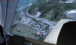
| Backcountry airfields for 19m terrain mesh in Idaho USA |
|
Images related to this file:
File Description:
These four backcountry fields are for use with the FSGenesis 19m mesh of Idaho, and are Big Creek, Johnson Creek, Dixie, and Sulphur Creek Ranch. They have been revised to fit and almost certainly do not work without the 19m mesh; a quick comparison with Big Creek before and after demonstrates the difference. I also have Ultimate Terrain installed. The three ingredients of terrain mesh, UT main roads, and UT streams, along with their individual margins of error, very often create conficts of space that make a grass runway impossible to site with it's correct length. Given the choice of turning off roads or streams (the terrain mesh cannot be turned off, obviously) I chose streams; the roads are less obviously incorrect, plus it matters not if roads go uphill while a climbing stream is to be avoided. On that basis the original series is reissued here for use with the 19m terrain mesh, on the presumption that you have already downloaded the original series. There are no textures or AI included as they remain the same as the originals, and the new scenery bgl's replace the originals to get the runways and grass etc in the right positions. There will be follow-on fields that are new, and all of the new ones will be only for the 19m mesh.
| Filename: | Backcountry_airfields_for_19m_terrain_mesh_in_Idah.zip |
| License: | Freeware, limited distribution |
| Added: | 29th May 2017, 04:19:43 |
| Downloads: | 124 |
| Author: | Roger Wensley |
| Size: | 2.22 MB |
| Category: Flight Simulator X - Scenery | |
| Carnes Farm |
|
Images related to this file:
File Description:
These are the files that I talked about in the Prepar3d forums. I created these objects for Fs9, then upgraded them to the scenery SDK for FSX. They were created 10 years ago in GMAX, and I have used them successfully ever since in Prepared 1.4 as well.
For some reason the individual farmhouse and other objects that I created are not showing up in Prepar3d version 2.0.
That's where you guys come in! These files are free to use in anyway you want as long as proper attribution is given, but, I would like you guys who have both Prepar3d 1.4 and 2.0 to try them out in both and report back to me as to whether you have the same problems that I do. That's your only fee. And I'd like you guys to give it a shot in both, or all four( I am not sure that they will work in FS9 anymore, but try it out. Unfortunately I can't recompile my FSX SDK Files back to FS9 if it doesn't work).
What's included:
1. Photo real scenery of Barbourville, 10 miles to the north west of stinking Creek where we live, and;
2. Photo real scenery of the farm area and stinking Creek, upon which I have placed my GMAX objects;
A. The farm house.Carnes Farm From the Bridge at 500 AGL.jpg
B. The barn, shed and the RV in back of the farmhouse.
C. A two-story long structure the top of which is an apartment but the bottom of which is a re-creation of Mama Carne's store, along with all the real wood floors shelves and original contents.. It is also o n Google earth in 3-D as it is here with further description .
... A little note on Gmax.. Mama Carne's store was one the first structures that I built in Gmax. It was just a box. Later, I added the true architectural features that you see including the steps and rails which took about as long to create as it would have to Saw and fit and hammer the real rails, risers and steps.
D. K-6, my little 2300 foot strip for runways 03 and 21. It has VOR - (117.55), ILS(110.1), and NDB(222).
E. Gerald Bingham's house, 1/4 mile up Warriors Path North from us.( mostly dirt road with gravel topping).
F. Dewitt Baptist Church.
Off property Knox county
G.Escoe's Store and Post Office complete with great prices for gas at the included pumps.
Escoes.jpg
H. Rex allen's killer corner...sheds and farm equipment on the sharpest bend on Stinking Creek...my son went off it with a flat tire, unscathed, but more than several have lost their lives on that curve... there may be several iterations of the sheds...just delete or rename the wrong ones...I was experimenting with ModelConverterX, Arno Gerretsen's wonderful model and object scenery tool.
I. sitting on top of the Barbourville Photo real scenery Barbourville PhotoReal over the shopping center.jpg is the Barbourville P3D Shopping Center2.jpg shopping center all the stores and all the storefronts ... it's on 25 E. as you head into Barbourville.
Recreated, is the entire shopping center with the now outmoded Wal-Mart sign. Probably my magnum opus.
note on the Gmax scenes.
All of the scenery was either directly measured and if not practical for a such a long measuring device, walked off, as in the Stinking Creek Bridge and shopping center. All of the objects were then photographed, in 360° where possible and saved as texture for inclusion in the Gmax model.
Enjoy!
...oh... how do you get there? Wellllll.... situate yourself at Middlesboro (1a6), and tune your Nav radio to K-69's VOR, 117.55, take off and climb to 3500 feet...grinnnnn
Welcome to Knox County Kentucky!
| Filename: | Carnes_Farm.zip |
| License: | Freeware |
| Added: | 2nd December 2013, 05:34:20 |
| Downloads: | 453 |
| Author: | Chas Honce |
| Size: | 91.13 MB |
| Category: Flight Simulator 2004 - Scenery | |
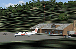
| Campbell River floats CAE3 in BC Canada |
|
Images related to this file:
File Description:
Campbell River is a medium sized town on Vancouver Island, some 50 miles north of Vancouver. The base is just north and west of the town on Spit Road. And Ultimate Terrain is required for the cost to be in the right place. The docks are on the south side of the spit, on the (relatively) sheltered river side, though take offs and landings are requested to take place outside the harbour if conditions permit. The base is noted as used and run by Corilair, though in fact there is also another company based there, Vancouver Island Air, who like Coril Air also have two docks, one for boarding passengers and one for maintenance and refuelling tie-ups. At the river mouth there is a small marina, run by the same folks who run the trailer park, and next to that a dock for visiting float planes. There is a seventh dock at the end furthest from the river mouth; I don't know what that is used for but it is next to Vancouver Island Air and might be theirs. At low tide there are numerous sandbanks (and more permanent islands with bushes and trees) in the mouth of the Campbell River and I decided to ignore installing these with all the problems they would cause me. The main buildings and most of the others are modeled specifically for this scenery; minor items like parked cars are RWY12.
| Filename: | Campbell_River_floats_CAE3_in_BC_Canada.zip |
| License: | Freeware, limited distribution |
| Added: | 12th February 2010, 18:45:00 |
| Downloads: | 880 |
| Author: | Roger Wensley |
| Size: | 5.3 MB |
| Category: Prepar3D V1-4 - Aircraft Repaints, Textures and Modifications | |
| North American P-51D 52nd FG (WD-M) 'Pendaja / Miss Ruth' |
|
Images related to this file:
File Description:
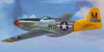
This folder contains a repaint for the A2A WoP3 P-51D Mustang (with AccuSim), in the colors of P-51D-5-NA 44-13287 WD-M, which was the aircraft assigned to Lt William Parent of the 4th FS/ 52nd FG, based in Italy. On the 1st of September 1944 however, it was being flown by Major Wyatt P. Exum during an escort mission to Hungary. It was Maj. Exum's first operational mission nin the ETO. On the way back from the mission, the squadron strafed an airfield, before spotting a moving train. Lts Strout and Wilson attacked the train, and as a result of Lt Wilson's attack, the engine blew up while he was overflying it, damaging his cooling system and setting the engine on fire. The fire quickly blew out, and Lt Wilson decided to make an belly landing in a recently plowed field. Over the radio, he heard Maj Wyatt Exum transmit "I'll be down to get you, Charlie!" and indeed he landed close to Lt Wilson's aircraft. Lt Wilson managed to turn Maj Exum's aircraft, as his tail wheel had become stuck in a rut in the field, and both men tried to squeeze into the cockpit. Meanwhile, men on horseback were approaching, shooting several holes in the aircraft. While Lt Wilson shot back with his .45, Major Exum gunned the engine, and they managed to take off with Lt Wilson half outside the cockpit with his .45. They flew the 400 miles back to Madna in Italy on their last fuel, and landed with other Mustangs landing from the other side. Major Exum received the Silver Star for this action, as well as from the undying gratitude and admiration from Lt Wilson Repaint by Jan Kees Blom, based on the A2A paintkit.
| Filename: | North_American_P51D_52nd_FG_WDM_Pendaja__Miss_Ruth.zip |
| License: | Freeware |
| Added: | 4th November 2018, 17:24:47 |
| Downloads: | 65 |
| Author: | Jan Kees Blom |
| Size: | 11.83 MB |
| Category: Flight Simulator X - Missions | |
| Discover FSX Flight (PAFA - PABR) (486 NM) (Heavy Cargo Run) |
|
File Description:
(PAFA - PABR) (486 NM) (Heavy Cargo Run)____Situation Orientation (Fictional) : Twice a year, (GREEN SOLUTIONS) a joint US-UN funded scientific research firm, based in Anchorage Alaska, charters a freighter jet to make a cargo run to (Barrow/Alaska (PABR)) located near the beaufort sea / Arctic ocean, where one of the firm's major research facilities is located. For the September run, it has been arranged that the flight will make a stop over at Fairbanks International Airport- Alaska (PAFA) to pick up additional cargo that a supplier working with the firm shipped to Fairbanks by train. As this run is a pre-winter run, the cargo is heavy and the cargo company have allocated a large freighter ship to handle the heavy cargo load. The aircraft arrived into Anchorage inbound from South America early this morning and departed Anchorage at 11:00 am. It arrived PAFA on time and is loading the additional cargo at a designated hanger. The flight was shedualedto depart to Barrow at 2:30 pm butfreighter paperwork and administrative complexities have caused a two and a half hour delay. Everyone, including you,is frustrated and anxious to get moving. Finaly, ground crews inform you that you will be ready to go in 10 ____Note : Although no significant malfunctions where logged during the first leg of the flight, the aircraft's maintenence logs indicate that during its Panama City departure,the crew logged an abnormalylow climb attitude after take off. However, due to compressed schedual timetables, maintenance operations in Anchorage decided that maintenance would be done after it returned from its charter flight and have given it a green light. As first officer, the captain has instructed you to watch that closley as he has given you control of this leg.
| Filename: | Discover_FSX_Flight_PAFA__PABR_486_NM_Heavy_Cargo_.zip |
| License: | Freeware |
| Added: | 30th September 2007, 15:11:13 |
| Downloads: | 5,090 |
| Author: | Ali Zied |
| Size: | 391.35 KB |
| Category: Flight Simulator 2004 - Scenery | |
| WASF Fak-Fak |
|
Images related to this file:
File Description:
Googly scenery for WASF Fak-Fak, in Irian Jaya (Western New Gunea),
Indonesia - a small domestic airport that Microsoft managed to omit from Flight
Simulator 2004. These scenery files add the runway, apron, taxiways, buildings
and other airport features so that you and your "AI" traffic can land, taxi,
park and take off in a realistic manner.
Little information is available on the services operated - flight plans are
available for Lion Airlines showing two flights per week operated on their behalf
by Wings Abadi Dash 8 aircraft. But it is known that Merpati Nusentara also serve
the airport with Twin Otters. If you are using the Lion Airlines flight plans
for Winter 2006, you must change the airport's co-ordinates as detailed in the readme.txt file
because the co-ordinates given there will cause the aircraft to aim for a point
on the wrong side of the equator in the middle of the sea!
There is no lighting at this airport, and few navigational aids. However, I have
added a missing NDB nearby (FA, 380.0).
The scenery does not purport to be ultra-accurate. The quality of the satellite
imagery at Google Earth is poor, but a number of photographs and other information
has enabled this airport to be depicted reasonably accurately. However the added
airport features, such as buildings, are built from default Microsoft objects
and add-on libraries so will not look exactly like the real thing.
You are not obliged to download and install any additional scenery libraries,
but to enjoy this scenery in its entirety, you may wish to. It will work fine,
with or without.
An editvoicepack file has been included for the airport to help you embarrass
yourself in front of others when flying.
[File re-uploaded at request of AVSIM]
| Filename: | WASF_FakFak.zip |
| License: | Freeware |
| Added: | 7th May 2010, 22:30:22 |
| Downloads: | 1,903 |
| Author: | John Hinson |
| Size: | 72.51 KB |
| Category: Flight Simulator X - AFCAD Files | |
| Ekdahl Airport (NJ59), NJ |
|
File Description:
Located 04 miles S of Freehold, New Jersey, Ekdahl Airport is a private turf strip 1300' in length bordered closely by trees. This makes for an interesting landing as the 90' width of the runway is all the room you have to play with. However because it can be difficult to gauge your distance to trees and also because even the slightest brush with a tree can cause a crash, all trees immediately adjacent to the runway have crash disabled - mainly so you can turn your plane around if you land on Runway 02. The hard surface runway was removed so make sure your terrain mesh complexity is set as high as possible to get that bumpy ground realism. A windsock is listed as being available on this field but I could not locate it in any imagery and so placed it by default near the hangar building. You can start on the runways or parked in front of the hangar. Make sure your plane is capable of these take off and landing distances! Tree height around the field was not listed so I again used my best judgement from studying aerial photos. There is no fuel or parking for transient aircraft available. The field is not lit - daytime VFR operations only are recommended.
Scenery constructed with use of satellite images/streetview/aerial photos - the author has not been there in person.
This scenery is meant to be used in conjunction with MegaScenery Earth New Jersey/Delaware 002. It is not required, but apron use is minimized to allow satellite scenery to show through as much as possible, and objects are placed based on the MSE textures - lack of it may make scenery look out of place.
| Filename: | Ekdahl_Airport_NJ59_NJ.zip |
| License: | Freeware |
| Added: | 13th August 2011, 16:53:55 |
| Downloads: | 172 |
| Author: | Drew Sikora |
| Size: | 550.03 KB |
| Category: Flight Simulator 2004 - Scenery | |
| MNPC Puerto Cabezas, Nicaragua |
|
Images related to this file:
File Description:
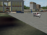
Googly scenery for MNPC Puerto Cabezas - a small international
airport in Nicaragua for which no facilities are provided in Microsoft Flight
Simulator 2004. These scenery files create the airport and add taxiways, aprons,
buildings and other airport features, so that you and your "AI" traffic can land,
taxi, park and take off in a realistic manner.
The airport, with its new Rigoberto Cabezas terminal opened in 2000, serves the
city of Puerto Cabezas and is surrounded by beautiful beaches and lush scenery.
Unfortunately, the country of Nicaragua has been embroiled in civil unrest almost
continuously since it became an independent republic in 1838, most of which is funded and fuelled by other countries seeking to interfere with Nicaragua's politics. For this reason, the country has no national airline or international flights of its own - the major powers refuse to accept its currency - and commercial traffic is confined to local flights operated by small craft from adjoining countries like those of Atlantic Airlines de Honduras and TACA Regional.
Fortunately, in Flight Simulator you do not need to worry about world politics
and you will be assured of a "virtual" welcome when you call in here. Please
say a small prayer for world peace when you do.
The scenery does not purport to be ultra-accurate. Based on high-detail satellite
imagery from Google Earth, the layout is proportionally correct but the added
airport features, such as buildings, are built from default Microsoft objects
and add-on libraries so will not look exactly like the real thing.
You are not obliged to download and install any additional scenery libraries,
but to enjoy this scenery in its entirety, you may wish to. It will work fine,
with or without. [File re-uploaded at request of AVSIM]
| Filename: | MNPC_Puerto_Cabezas_Nicaragua.zip |
| License: | Freeware |
| Added: | 28th May 2010, 20:36:10 |
| Downloads: | 1,149 |
| Author: | John Hinson |
| Size: | 67.63 KB |
© 2001-2026 AVSIM Online
All Rights Reserved
Privacy Policy |