
Where Flight Simulation Enthusiasts Gather from Around the World!
AVSIM Library - Search Results

| Category: Flight Simulator 2004 - Scenery | |
| EVVA Ventspils International, Latvia |

|
Images related to this file:
File Description:
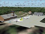
Googly scenery for Ventspils International - Latvia's third largest commercial airport
(try not to laugh!) although no facilities other than a runway are provided in Flight
Simulator 2004. These scenery files add taxiways, aprons, buildings and other airport
features, so that you and your "AI" traffic can land, taxi, park and take off in a
realistic manner.
The airport serves the city of Ventspils in northwest Latvia and opened as recently
as 1975. Owing to changes in the political situation, operations ceased in 1983 but
it re-opened in 2000. At present, it is unclear which operators serve the airport
- Air Baltic is the claimed contender but there is no evidence in their advertised
schedules. It is believed that occasional flights are operated to St Petersburg and
Moscow by Russian operators but information is hard to come by. Nevertheless, the
airport's own web site (http://www.airport.ventspils.lv/) has figures showing the
increasing numbers of passengers passing through the airport, so something must
call here! The airport also sees a respectable amount of General Aviation activity
and AVGAS has recently been made available.
The scenery does not purport to be ultra-accurate. Based on high-detail satellite
imagery from Google Earth, the layout is proportionally correct but the added
airport features, such as buildings, are built from default Microsoft objects
and add-on libraries so will not look like the real thing. [File re-uploaded at request of AVSIM]
| Filename: | EVVA_Ventspils_International_Latvia.zip |
| License: | Freeware |
| Added: | 15th June 2010, 00:59:50 |
| Downloads: | 1,596 |
| Author: | John Hinson |
| Size: | 89.79 KB |
| Category: Flight Simulator 2004 - Scenery | |
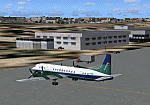
| Sisimiut (BGSS) on the west coast of Greenland |
|
Images related to this file:
File Description:
Sisimiut is on the west coast of Greenland. It is around 125 miles south of Aasiaat, and 80 miles west of Kangerlussuaq airport, which is currently the largest commercial airfield in Greenland. Sisimiut has a population of 5,500 and the main occupations are fishing, tourism, education, and a growing industrial base. It has the northernmost year-round ice-free port in Greenland, though icebergs floating down from the north are commonplace. The airport is across a bridge and along a two mile road on the north side of an inlet, northwest of the town. The runway is 2,600+ feet of asphalt almost 100 feet wide and lit, aligned 20/02 and at 33 feet ASL, with the apron and terminal building at the eastern end. The building is identical to the one at Aasiaat. Air Greenland run regular flights with a Dash-8, Dash-7, or Twin Otters; within FS9 it is impossible to land an Ai Dash-7 on a runway less than 3,000 feet long, so I used a Dash-8. There was no way to replicate both the parking facing away from the terminal AND the "through" taxiing to complete the circle back to the runway; after parking correctly the AI Air Greenland plane will reverse before heading out to take off. The surrounding area is rock with some scruffy grass and low bushes, and there is no grass around the runway; the airfield has compacted gravel instead.
| Filename: | Sisimiut_BGSS_on_the_west_coast_of_Greenland.zip |
| License: | Freeware, limited distribution |
| Added: | 28th April 2012, 22:03:35 |
| Downloads: | 850 |
| Author: | Roger Wensley |
| Size: | 3.71 MB |
| Category: Flight Simulator 2004 - Scenery | |
| Hana Heli-Obstacle Course v3.0 |
|
File Description:
Hana Airport is a regional airport of the State of Hawaii on the east shore of the island of Maui, 3 NM northwest of the unincorporated town of Hana. The airport covers 119 acres and has one runway. It is primarily a commuter facility used by unscheduled air taxis and general aviation. This scenery is intended as a single/multiplayer helicopter obstacle course where heli pilots can meet to compete, show off, and share their helo skills. Since birdseye (Timm Turner) already did a neat scenery called Hana_Scenery_PHHN (search for "hana" in the HoverControl Downloads), we decided to convert PHHN to a full helicopter training area. Makes a great place for helo pilots to gather to practice and perfect their skills, and challenge other pilots! And keep an eye-out for that Hot Air Balloon, cruising around an altitude of 3000 feet (don't forget to wave at them!).
Another unique thing about this scenery is the neighboring islands (Honolulu Intl/Hickam AFB, Bellows AFB, Lanai City, Kahului, Molokai, etc). If you get frustrated during your heli obstacle course training, just take a heading of 275 degrees, and relax at one of the neighboring islands. We also added an Easter Egg - If you set your FS calendar to July 21st, you'll see a large ridge fire up in the hills. Load Jordan Moore's Erickson S64E (http://www.hovercontrol.com/) & try your skills at water bombing!
| Filename: | Hana_HeliObstacle_Course_v30.zip |
| License: | Freeware |
| Added: | 28th August 2011, 17:53:18 |
| Downloads: | 467 |
| Author: | Greg Spellmen, Bob Ferguson |
| Size: | 95.52 MB |
| Category: Flight Simulator 2004 - Scenery | |
| Hana Heli-Obstacle Course v2.0 |
|
Images related to this file:
File Description:
Hana Airport is a regional airport of the State of Hawaii on the east shore of the island of Maui, 3 NM northwest of the unincorporated town of Hana. The airport covers 119 acres and has one runway. It is primarily a commuter facility used by unscheduled air taxis and general aviation. This scenery is intended as a single/multiplayer helicopter obstacle course where heli pilots can meet to compete, show off, and share their helo skills. Since birdseye (Timm Turner) already did a neat scenery called Hana_Scenery_PHHN (search for "hana" in the HoverControl Downloads), we decided to convert PHHN to a full helicopter training area. Makes a great place for helo pilots to gather to practice and perfect their skills, and challenge other pilots! And keep an eye-out for that Hot Air Balloon, cruising around an altitude of 3000 feet (don't forget to wave at them!). Another unique thing about this scenery is the neighboring islands (Honolulu Intl/Hickam AFB, Bellows AFB, Lanai City, Kahului, Molokai, etc). If you get frustrated during your heli obstacle course training, just take a heading of 275 degrees, and relax at one of the neighboring islands. We also added an Easter Egg - If you set your FS calendar to July 21st, you'll see a large ridge fire up in the hills. Load Jordan Moore's Erickson S64E (http://www.hovercontrol.com/) & try your skills at water bombing!
| Filename: | Hana_HeliObstacle_Course_v20.zip |
| License: | Freeware |
| Added: | 7th December 2010, 03:28:47 |
| Downloads: | 475 |
| Author: | Greg Spellmen & Bob Ferguson |
| Size: | 58.56 MB |
| Category: Flight Simulator 2004 - Scenery | |
| HCMM - Mogadishu International Airport, Mogadishu/Petrella, Somalia |
|
Images related to this file:
File Description:
Googly scenery for HCMM Mogadishu/Petrella, the capital airport of Somalia.
Astonishingly, in Flight Simulator 2004 this international airport is depicted as little
more than a runway! Whilst in the real world the airport can hardly be
described as busy, it is served by the country's sole airline - Jubba
Airways, with their wonderful Ilyushin IL-18, and many African and Eastern
European operators call by with cargo flights. In fact, the vast proportion of
the aircraft seen here are Russian-built.
These scenery files add aprons, taxiways, buildings and other airport features to Flight Simulator's limited representation and allow "AI" traffic to land, taxi, park and take off in a realistic manner. But do watch out for cars on the runway and taxiways as they
appear to be regularly used as a by-pass to the perils of driving through the city!
The scenery does not purport to be ultra-accurate. Based on high-detail satellite
imagery from Google Earth, the layout is proportionally correct but the added
airport features, such as buildings, are built from default Microsoft objects
and add-on libraries so will not look exactly like the real thing.
You are not obliged to download and install any additional scenery libraries,
but to enjoy this scenery in its entirety, you may wish to. It will work fine,
with or without. [File re-uploaded at request of AVSIM]
| Filename: | HCMM__Mogadishu_International_Airport_MogadishuPet.zip |
| License: | Freeware |
| Added: | 28th May 2010, 20:46:31 |
| Downloads: | 2,790 |
| Author: | John Hinson |
| Size: | 61.51 KB |
| Category: Flight Simulator X - Utilities | |
| AIRound v2.0 |
|
File Description:
FSX AIRound v2.0. This utility enables forward (VC-like), fly by, spot and top-down views of other players’ aircraft and AI-controlled airplanes, ground vehicles and boats. There are three special view modes for AI aircraft landings and take-offs. Continuous AI aircraft following all the way to its destination is available. There are lots of parameters of participating airplanes, assistance in formation flying, etc. For more utility features see its ReadMe.txt file. There are 4 FSX sessions for free. By Valery Stenin.
| Filename: | AIRound_v20.zip |
| License: | Shareware, time limited |
| Added: | 29th June 2008, 23:29:43 |
| Downloads: | 2,422 |
| Author: | Valery Stenin |
| Size: | 922.59 KB |
| Category: Flight Simulator 2004 - AFCAD Files | |
| LATI - Tirana International Airport Nënë Tereza (Default) |
|
File Description:
This is part of the second round of Afcads issued by Alpha India Group. AIG Ground aims to create high quality Afcads for both FS2004 and for FSX default and add on scenery airports. Our Afcads are created drawing on a number of resources and aim to simulate the real world airport as closely as possible but also to take account of FS constraints and ensure good levels of traffic and realistic traffic parking and flow around the airport. Visit us at www.alpha-india.net for more information.
| Filename: | LATI__Tirana_International_Airport_Nn_Tereza_Defau.zip |
| License: | Freeware, limited distribution |
| Added: | 8th February 2009, 19:40:59 |
| Downloads: | 1,101 |
| Author: | Bob Clements & Alpha India Group |
| Size: | 253.18 KB |
| Category: Flight Simulator 2004 - AFCAD Files | |
| EDDK - Cologne/Bonn Airport Konrad Adenauer (Aerosoft) |
|
File Description:
This is part of the second round of Afcads issued by Alpha India Group. AIG Ground aims to create high quality Afcads for both FS2004 and for FSX default and add on scenery airports. Our Afcads are created drawing on a number of resources and aim to simulate the real world airport as closely as possible but also to take account of FS constraints and ensure good levels of traffic and realistic traffic parking and flow around the airport. Visit us at www.alpha-india.net for more information.
| Filename: | EDDK__CologneBonn_Airport_Konrad_Adenauer_Aerosoft.zip |
| License: | Freeware, limited distribution |
| Added: | 8th February 2009, 19:43:00 |
| Downloads: | 2,006 |
| Author: | Philippe Plein & Alpha India Group |
| Size: | 626.97 KB |
| Category: Flight Simulator 2004 - AFCAD Files | |
| VHHH - Chek Lap Kok, Hong Kong SAR (Thomas Kwong scenery) |
|
File Description:
This is part of the second round of Afcads issued by Alpha India Group. AIG Ground aims to create high quality Afcads for both FS2004 and for FSX default and add on scenery airports. Our Afcads are created drawing on a number of resources and aim to simulate the real world airport as closely as possible but also to take account of FS constraints and ensure good levels of traffic and realistic traffic parking and flow around the airport. Visit us at www.alpha-india.net for more information.
| Filename: | VHHH__Chek_Lap_Kok_Hong_Kong_SAR_Thomas_Kwong_scen.zip |
| License: | Freeware, limited distribution |
| Added: | 8th February 2009, 19:39:33 |
| Downloads: | 2,238 |
| Author: | Mariano Bonaccorso & Alpha India Group |
| Size: | 871.71 KB |
| Category: Flight Simulator 2004 - AFCAD Files | |
| Updated AFCAD for Concord Regional, North Carolina (KJQF) |
|
Images related to this file:
File Description:
If you are like me, maybe you have broken out of the clouds on an ILS approach to JQF and find that the runway in front of you is almost 2,000 feet shorter than the one on your current airport diagram. This file will take care of that (and then some). Lengthens the runway to 7,400 feet, adds new taxiways and buildings, updates all taxiway signs, and adds the north taxiway/buildings for Ganassi Racing. Uses all generic scenery items--requires no additional files. Enjoy!
| Filename: | Updated_AFCAD_for_Concord_Regional_North_Carolina_.zip |
| License: | Freeware |
| Added: | 1st July 2011, 22:00:21 |
| Downloads: | 289 |
| Author: | Derek Herchko |
| Size: | 7.85 KB |
© 2001-2026 AVSIM Online
All Rights Reserved
Privacy Policy |