
Where Flight Simulation Enthusiasts Gather from Around the World!
AVSIM Library - Search Results

| Category: Orbiter - Miscellaneous Files | |
| City Builder Tool |

|
File Description:
The tool (a 50 kb Java application) provides a GUI where you just click and place bases, rivers, blocks, churchs, parks, runway, solarplants etc.
Then you click "produce" and the tool writes your My_Cool_Base.cfg file for your
OrbiterConfig folder.
In this way I build my home town, with parks and churchs,
and I take off from there, now ...
Note: this is an alpha version from the "features point of view", but it is almost a beta release from the "testing point of view".
In other words (I know Avsim requires at least beta's) the tool works well, simply it is not completed (some features are missing).
I made this tool just for fun. So, if you really think is worthy going on with it, or that it's a funny/useful tool, please let me know.
If I see that the tool is useful for the Orbiter community, I will complete it more quickly and I will post a real beta release in a couple of weeks.
REMARK: you need Java to run this tool!
| Filename: | City_Builder_Tool.zip |
| License: | Freeware |
| Added: | 20th October 2003, 18:23:03 |
| Downloads: | 1,003 |
| Author: | Stefano Adriani |
| Size: | 46.02 KB |
| Category: Flight Simulator 2004 - Scenery | |
| Hana Heli-Playground v1.0 |
|
Images related to this file:
File Description:
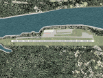
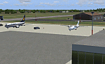
Hana Airport is a regional airport of the State of Hawaii on the east shore of the island of Maui, 3 NM northwest of the unincorporated town of Hana. The airport covers 119 acres and has one runway. It is primarily a commuter facility used by unscheduled air taxis and general aviation. This scenery is intended as a single/multiplayer helicopter obstacle course where heli pilots can meet to compete, show off, and share their helo skills. Since birdseye (Timm Turner) already did a neat scenery called Hana_Scenery_PHHN (search for "hana" in the HoverControl Downloads), we decided to convert PHHN to a full helicopter training area. Makes a great place for helo pilots to gather to practice and perfect their skills, and challenge other pilots! And keep an eye-out for that Hot Air Balloon, cruising around an altitude of 3000 feet (don't forget to wave at them!).
Another unique thing about this scenery is the neighboring islands (Honolulu Intl/Hickam AFB, Bellows AFB, Lanai City, Kahului, Molokai, etc). If you get frustrated during your heli obstacle course training, just take a heading of 275°, and relax at one of the neighboring islands.
| Filename: | Hana_HeliPlayground_v10.zip |
| License: | Freeware |
| Added: | 9th May 2010, 11:29:39 |
| Downloads: | 524 |
| Author: | Bob Ferguson |
| Size: | 27.79 MB |
| Category: Flight Simulator 2004 - AFCAD Files | |
| PAKT Ketchikan International, Alaska, USA |
|
Images related to this file:
File Description:
Googlyafcad A&F Data file for Ketchikan International based on Google Earth satellite
data - a small but relatively busy airport located in one of the wettest parts of
Alaska, USA. Ketchikan is Alaska's fifth largest city, with its economy based on
salmon fishing.
For some curious reason the facilities provided in Flight Simulator 2004 omit a crucial
taxiway at the west end of the airport, causing all traffic to taxi from the opposite
end. These files redress this issue, and also provide realistic levels of parking for
commercial and general aviation traffic, allowing you and your "AI" traffic to land,
taxi, park and take off in a realistic manner. The layout has been cunningly designed
to fit both with the Flight Simulator default scenery and version 2 of Alan Wright's
enhanced scenery (paktv2.zip on AVSIM) and is compatible with both in every respect.
Apart from conventional and water-based general aviation aircraft Ketchikan International
is regularly served by commercial flights of Alaska Airlines and by smaller operators
such as Alaska Central Express, Everts Air Alaska and LAB Flying Service. [File re-uploaded at request of AVSIM]
| Filename: | PAKT_Ketchikan_International_Alaska_USA.zip |
| License: | Freeware |
| Added: | 29th May 2010, 09:28:41 |
| Downloads: | 1,266 |
| Author: | John Hinson |
| Size: | 206.01 KB |
| Category: Flight Simulator X - Scenery | |
| 1F2 - Plateau Sky Ranch - Edinburg, NY |
|
File Description:
Here is an improved version of the stock Plateau Sky Ranch. This is a privately owned field, open to the public. It consists of two grass runways and is located just north of the Great Sacandaga Lake.
In FSX, there were no buildings at all, so I added the hangar, and the hangars and planes that are located across a public road. I moved both runways because, with UTX, the road crossed both runways. Now the runways clearthe road. In FSX there were taxiways with hold-short lines, taxiway signs, etc, which didn't belong so they
were removed. I added a dirt driveway, parking area, fuel station, light pole, flag, and a couple of local houses and barn.
There is a lot of nice scenery in any direction from Plateau Sky Ranch. If you take off from runway 6 and follow the waterway you will come to the earthen Conklingville dam and the upper Hudson River.
I've added an extra file for UTX users called Boats.bgl. It will add several marinas and boats in correct locations on the Great Sacandaga Lake.
| Filename: | 1F2__Plateau_Sky_Ranch__Edinburg_NY.zip |
| License: | Freeware |
| Added: | 22nd March 2009, 17:44:40 |
| Downloads: | 1,347 |
| Author: | Jim Cook |
| Size: | 4.56 KB |
| Category: Flight Simulator 2004 - Scenery | |
| Camden Field in Trinidad |
|
File Description:
Camden Field was once a wartime American airfield, which shows up in the wide east-west runway that has more recently been partly resurfaced. There are no runway markings beyond a centre line, and it just sort of tapers off at the sides and the eastern end into the bush. In contrast to the renovated hangar to the north of the western end of the runway the buildings to the south haven't been touched by any recent tender-loving-care. There is a wonderful patched-together shed and a small control tower, which was built on the edge of the existing runway. This makes it appear rather close to the edge of the resurfaced runway area. Do not be fooled, this is not an illusion; it IS close to the edge of the runway. Just take comfort in the thought that the prevailing southeast winds (for much of the year) will tend to blow you away from it as you approach for a landing from the west. And I kept the pre-renovation version of the old hangar when I found some old pics of the crop dusting operation from five years ago.
| Filename: | Camden_Field_in_Trinidad.zip |
| License: | Freeware |
| Added: | 14th December 2008, 01:32:05 |
| Downloads: | 536 |
| Author: | Roger Wensley |
| Size: | 2.73 MB |
| Category: Flight Simulator 2004 - Panels | |
| Generic Customized Advanced Panels |
|
File Description:
FS2004 Generic Advanced Customized Panels. Since this panel includes All XML gauges for 2-, 3- and 4 Jet engines aircrafts, Concorde and Warplains for 1 and 2 Engines, including landing panel. Special effects of the visor in the mainpanel of the Concorde. It can be used for any heavy jet. Also you have 3 choices, between the metal gray color panel (old Boeing) or the brown color of the FS2004 boeing default and the feeling to be in a Airbus (PFD of A380). All gauges are on the same place in the different engine version or airplane, no more memorizing the different panels. It has a full working overhead, TCAS radar, ATC control, customized FS2004 GPS, ACS-GPS, APU, FMC, HUD, Wiper and many custom xml gauges. Special attention is made on the Radio, Fuel, PFD, Clock, Taxi speed control, Wind speed, Bank rate, Auto mb-Hg, Push back,and Sim speed. A lot of information during take off, flight and landing. Many warnings included. Ideal panel for beginners and advanced simmers. Special Credit of gauges to Acsoft, Arne Bartels, Eric Mariano, Björn Karlsson, Tony d'Ambrosi, Nick Pike, etc. Panel design and gauges by Guy de Smet.
| Filename: | Generic_Customized_Advanced_Panels.zip |
| License: | Freeware |
| Added: | 16th January 2004, 23:00:39 |
| Downloads: | 16,066 |
| Author: | Guy De Smet |
| Size: | 10.3 MB |
| Category: Flight Simulator X - Original Aircraft | |
| F-15 S/MTD |
|
File Description:
This is my second release for the FS community.
The F-15 S/MTD is a STOL variant of the all-weather tactical
fighter F-15 Eagle. While S/MTD stands for Short take off and landing
/Maneuver Technology Demonstrator, the actual plane has F-18's elevators
as canard wings and a two-dimensional thrust vectoring, which gives the
aircraft an exceptionnal maneuvrability. Developed as a technology
demonstrator, the F-15 S/MTD carried out research for studying the
effects of vectored thrust and enhanced maneuverability. The NASA has
modified an F-15 Eagle by adding canard wings and by replacing the
original engines nozzles by two Pratt & Whitney P/YBBN 20 Degree
two-dimensional thrust vectoring nozzles. The F-15 S/MTD can also
perform the famous "Pugachev's Cobra" maneuver. The same aircraft would
later be used for the F-15 ACTIVE (with three-dimensional vectored
thrust) and for the F-15 IFCS (with three-dimensional vectored thrust
and with improved avionic). Features all the basic animations
(retractable landing gear, steering wheel, working suspension, working
surfaces plus thrust vectoring nozzles and moving engines inlets) and
afterburner. Sorry, no VC.
Model made in Gmax by Thomas Lebel.
| Filename: | F15_SMTD.zip |
| License: | Freeware |
| Added: | 19th February 2008, 00:35:34 |
| Downloads: | 3,266 |
| Author: | Thomas Lebel |
| Size: | 4.85 MB |
| Category: Flight Simulator 2004 - Scenery | |
| Hicks Farm Field CF12 near Ottawa in Ontario, Canada |
|
Images related to this file:
File Description:
Hicks Farm is in Ontario and around 8 miles west of Rideau Valley Airpark CPL3 (which did not appear in FS9, probably because it was then mainly used by gliders, but is a post of mine). CPL3 is 15 miles south of Ottawa Airport, tucked into a right angle bend of the Rideau River. Ultimate Terrain puts the river into place, and I am not sure of how or if either CPL3 or CF12 work without UT, maybe somebody can let me know. Fly west from CPL3 along the river and Hicks Farm will be on the south side. It has a (mainly) grass runway 34/16 with a section of asphalt and totals some 5,500 feet overall. Alan, the owner of Hicks Farm, is in his mid 80's and was told last year that his insurance company no longer felt comfortable with him flying his Lear off a farm strip. The result of his enforced retirement from flying his Lear is that the grass has been allowed to take over somewhat, though there is still sufficient space to land most single engine light aircraft.
| Filename: | Hicks_Farm_Field_CF12_near_Ottawa_in_Ontario_Canad.zip |
| License: | Freeware, limited distribution |
| Added: | 11th February 2010, 00:50:23 |
| Downloads: | 271 |
| Author: | Roger Wensley |
| Size: | 1.43 MB |
| Category: Flight Simulator 2004 - Scenery | |
| VABP Bhopal/Bairagarh, India |
|
Images related to this file:
File Description:
Googly scenery for VABP Bhopal/Bairagarh, India - an enhancement to the
airport provided in Flight Simulator 2004 which is incorrect in many respects.
These scenery files enlarge the apron to a realistic size to accept scheduled
traffic, remove spurious taxiways (they were actually perimeter tracks!), and
add buildings and other airport features so that you and your "AI" traffic
can land, taxi, park and take off in a realistic manner.
This small domestic airport is served by Boeing and Airbus jets of Indian
Airlines and Jet Airways together with local flights operated by ATRs of Air
Deccan.
The scenery does not purport to be ultra-accurate. Based on high-detail satellite
imagery from Google Earth, the layout is proportionally correct but the added
airport features, such as buildings, are built from default Microsoft objects
and add-on libraries so will not look like the real thing.
You are not obliged to download and install any additional scenery libraries,
but to enjoy this scenery in its entirety, you may wish to. It will work fine,
with or without.
[File re-uploaded at request of AVSIM]
| Filename: | VABP_BhopalBairagarh_India.zip |
| License: | Freeware |
| Added: | 7th May 2010, 22:34:06 |
| Downloads: | 1,625 |
| Author: | John Hinson |
| Size: | 64.37 KB |
| Category: Flight Simulator 2004 - AI Aircraft | |
| Aerolineas Damojh Boeing 737-5Y0 Full Fleet Pack |
|
Images related to this file:
File Description:

This are the aircrafts of the extinct mexican charter airline Aerolineas Damojh, the Boeing 737-5Y0 full fleet pack contain the next airlines and aircrafts that used the Aerolineas Damojh aircrafts and paints with the registrations: Aeroregional: HC-CTF (With New Tail Logo and No Titles), HC-CUH (With New Tail Logo and No Titles). EasySky: HC-CPC, HR-AYS, HR-EMH (With Blue Engines and Club Atletico River Plate). Global Air: XA-UZK (With LAC No Titles). Linea Aerea Cuencana: HC-COP. Sudamericana de Aviacion: HC-COP, HC-CPC Aerolineas Damojh ceased operations in 2019 after the accident in "La Habana Cuba" were it crashed the XA-UHZ in take off maneuvers, moving all the operations and the new aircrafts "Boeing 737-5Y0" to Ecuador, abandoning all the 3 "Boeing 737-200Adv" that were from this airline, they were "XA-UHY", "XA-UMQ", and "XA-TWR". AerolÃneas Damojh, S.A. de C.V. is the official name of this company, the commercial name that had was "Global Air". The models of this traffic are FSX AI BUREAU (FAIB) Boeing 737-500. This is my website: https://el-mundo-de-los-aviones-ai-traffic.jimdosite.com I hope enjoy it!
| Filename: | Aerolineas_Damojh_Boeing_7375Y0_Full_Fleet_Pack.zip |
| License: | Freeware |
| Added: | 25th June 2022, 15:57:09 |
| Downloads: | 36 |
| Author: | Jesus Gibran Soriano Solleiro |
| Size: | 81.16 MB |
© 2001-2026 AVSIM Online
All Rights Reserved
Privacy Policy |