
Where Flight Simulation Enthusiasts Gather from Around the World!
AVSIM Library - Search Results

| Category: Flight Simulator 2004 - AFCAD Files | |
| (NTTB)(NTTH) French Polynesia Start Locations |

|
File Description:
These files are for Bill Melichars beautiful airports Bora2 and Huaine2, they add the start locations for the Helipads, these are the same afcad files from the scenery but with these starting points added for the Heli-pilots
| Filename: | NTTBNTTH_French_Polynesia_Start_Locations.zip |
| License: | Freeware |
| Added: | 1st June 2010, 09:08:48 |
| Downloads: | 3,584 |
| Author: | Ray Smith |
| Size: | 3.59 KB |
| Category: Flight Simulator 2004 - Aircraft Repaints, Textures and Modifications | |
| Piper Tri-Pacer |
|
File Description:
This is a repaint of the wonderful Tri-Pacer created by Bill Lyons of the Golden Eagles Squadron. It is a reproduction of the one I owned back in the 60s. Original aircraft needed, details in the download.
| Filename: | Piper_TriPacer.zip |
| License: | Freeware |
| Added: | 1st June 2005, 04:58:44 |
| Downloads: | 693 |
| Author: | Leon Louis |
| Size: | 823.02 KB |
| Category: Flight Simulator X - AFCAD Files | |
| Los Angeles International-KLAX |
|
File Description:
This is for the FSdreamteam version of KLAX only. The parking codes were changed to reflect the current gate assignments at KLAX. I also coded the West parking gates to help with the overflow from United and American
| Filename: | Los_Angeles_InternationalKLAX.zip |
| License: | Freeware |
| Added: | 12th June 2017, 17:41:57 |
| Downloads: | 736 |
| Author: | Arluster Turner |
| Size: | 25.3 KB |
| Category: Flight Simulator 2004 - Original Aircraft | |
| Grumman f9f Cougar |
|
Images related to this file:
File Description:

The Grumman F9F/F-9 Cougar was an aircraft carrier-based fighter aircraft for the United States Navy. Based on the earlier Grumman F9F Panther, the Cougar replaced the Panther's straight wing with a more modern swept wing.
| Filename: | Grumman_f9f_Cougar.zip |
| License: | Freeware |
| Added: | 30th July 2010, 18:37:46 |
| Downloads: | 2,465 |
| Author: | Peter Mercy / Kazunori Ito |
| Size: | 19.39 MB |
| Category: Prepar3D V1-4 - Aircraft Repaints, Textures and Modifications | |
| North American P-51D 364th FG (5E-V) 'Estrellita' |
|
Images related to this file:
File Description:
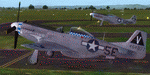
This folder contains a repaint for the A2A WoP3 P-51D Mustang, in the colors of P-51K #44-64077 5E-V "Estellita" of Lt. Curtis L. Smart, of the 385th FS/364th FG, based in Honington, UK. As the story goes, just prior to being assigned to England to fly fighter aircraft, Lt. Smart’s wife gave birth to the first of three daughters. Estrellita was the title of a Mexican song that was popular in those days, which translated to “Little Starâ€, and this was given to the child as her name. Smart’s first P-51 was named Estrellita but the aircraft was lost, so too was the second and ultimately he received the third aircraft to bear the name, now Estrellita III. The nose art was never completed as intended. If you notice the odd extension to the bottom of the “Eâ€, this was supposed to be a shooting star with a classic early US star with red center forming the shooting star portion.
Repaint by Jan Kees Blom, based on the A2A paintkit.
| Filename: | North_American_P51D_364th_FG_5EV_Estrellita.zip |
| License: | Freeware |
| Added: | 3rd November 2018, 23:26:23 |
| Downloads: | 38 |
| Author: | Jan Kees Blom |
| Size: | 13.1 MB |
| Category: Flight Simulator 2004 - Utilities | |
| AirTrack Plug-in v1.4 |
|
Images related to this file:
File Description:

This is an update of the Microsoft Flight Simulator 9/2004 plug-in for the AirTrack iPhone, iPad and iPod Touch app. In order to install it run the executable that will deploy a gauge in the proper folder and automatically activate it.
AirTrack is an App that allows tracking of FS9 flights on your iPhone or iPad in real time using a local wireless network with built-in parameter reporting, an EFIS MFD, an FMC and Airport information. You can also command the plane from the application.
The current update fixes some bugs, improves the communication between the plug-in and the applicaiton and allows the flight plan created at the Flight Simulators to be displaid in the AirTrack. It also adds support for speeds limits, flight director bars in the PDF and VAS selector.
To learn more about the app and its availability please visit the product' site: air.ipobjects.com. If you have any question regarding the FSX plug-in you can contact us at [email protected]
| Filename: | AirTrack_Plugin_v14.zip |
| License: | Freeware |
| Added: | 10th May 2011, 13:46:01 |
| Downloads: | 189 |
| Author: | Jofre Palau |
| Size: | 296.36 KB |
| Category: Flight Simulator 2004 - Aircraft Repaints, Textures and Modifications | |
| Air New Zealand Airbus A320-232 v1.1 |
|
File Description:
iFDG is proud to present the Airbus A320. The aircraft model includes most of the standard features including animated control surfaces, wingviews, flaps, full lighting configuration, and highly detailed, reflective textures. "The A320 was launched on March 2, 1984. It is the first subsonic commercial aircraft with fly-by-wire controls. First flight took place on February 22, 1987. The A320-100 was the initial version and was superseded by the A320-200 from the third quarter of 1988. The A320-200 differs from the A320-100 in having wingtip fences, a wing center-section fuel tank, and a higher MTOW. This package features ZK-OJF, A brand new A320-232 of Air New Zealand. v1.1 removes the small green line under the port wing(left accidentally), adds the effects folder for those who don't have it and corrects the sound folder name so the sounds will work correctly without editing. This is a full package rather than just an update as I thought that would be more convenient and less confusing for the majority of users.
| Filename: | Air_New_Zealand_Airbus_A320232_v11.zip |
| License: | Freeware, limited distribution |
| Added: | 4th March 2004, 17:02:41 |
| Downloads: | 3,733 |
| Author: | Michael Corcoran, iFDG |
| Size: | 5.29 MB |
| Category: Civil Flight Simulators - Looking Glass Flight Unlimited 3 | |
| FU3 JoyKey.CFG for MS Sidewinder Precision Pro Joystick v3 |
|
File Description:
This file is for Flight Unlimited III using MS Sidewinder Precision Pro joystick only. I believe you can adapt it to any joystick, but I have no way of testing this.
JoyKeys_v3 corrects the trim function so that you DON'T have to "tap" the trim buttons to trim the aircraft. Just press and hold as it should be. Thanks Allan Dawson for the tip.
JoyKeys_v2 added the air brakes function to the reverser fuction already active on button 7. The reverser only works while the aircraft is on the ground. The air brakes work in the air and on the ground if the plane you have selected is equipped. These fuctions ONLY work with JETS. This file will assign the most common flight control functions to your joystick buttons for MS Sidewinder Precision Pro Joystick. These are my preferences. You can change them around at your discretion. All the documentation is in the readme from the FU3 patch. You can try this file... if you don't like it, delete it. All will be as before.
| Filename: | FU3_JoyKeyCFG_for_MS_Sidewinder_Precision_Pro_Joys.zip |
| License: | Freeware |
| Added: | 27th October 2002, 14:59:38 |
| Downloads: | 715 |
| Author: | Earl Buice |
| Size: | 2.12 KB |
| Category: Flight Simulator 2004 - Aircraft Repaints, Textures and Modifications | |
| Channel Airways (ex BEA) DH Comet 4B G-APMB |
|
File Description:
Channel Airways bought five Comet 4B aircraft from BEA to operate inclusive tours out of Stansted. This was the only ex BEA machine, the other four had been in service with Olympic Airways. None of the aircraft were painted in Channel colours, remaining in the basic livery of their former operators left G-APMB as the odd one out in the fleet. The first to arrive in January 1970 was one of the former Greek aircraft and the type made it debut on the 25th February with G-APYC flying from Stansted to Palma. The Comet proved a disaster for the airline and a spares shortage and technical difficulties forced it to buy an Mexicana Comet 4 in June 1971 which was immediately broken up to provide spares. The airline as a whole was in serious trouble and with fortunes continuing to decline all jet operations were suspended in January 1972. The airline ceased flying at the end of the following month. Requires the DH 106 Comet 4B model by David Maltby
| Filename: | Channel_Airways_ex_BEA_DH_Comet_4B_GAPMB.zip |
| License: | Freeware |
| Added: | 10th June 2005, 12:07:43 |
| Downloads: | 304 |
| Author: | Garry Russell |
| Size: | 546.5 KB |
| Category: Flight Simulator 2004 - Aircraft Repaints, Textures and Modifications | |
| Gruppo di Addestramento Aeronáutico - Rivolto (UD) and ‘Giro dell’Italia Aereo’ Embraer EMB-110 Bandeirante |
|
File Description:
Original plane created by J.E.Narcizo - RanchoJEN, downloadable in this address :
http://www.simviation.com/fs2004props59.htm. Repaints in the colors of the 313° Gruppo di Addestramento Aeronáutico - Rivolto (UD) and ‘Giro dell’Italia Aereo’- In the end of 1960, the Aeronautica Militare Italiana decide that was the moment had just created Pattuglia Acrobática Nazionale with its permanent seat on the basis of Rivolyo del Friuli. While following was created the 313e Gruppo Addestramento Acrobatico Groupe Lifting Formation), more known under not of Frecce Tricolori. The formation consists of nine apparatuses plus a solo and is perceived as the lifting patrol most, although it is among most prestigious, of the world. Frecce Tricolori can be in all the cases considered as the bests of the lifting formation resulting from the school of Campoformido around the years 1930. The EMB-110 Bandeirante, here repaints, is a non-pressurized plane intended for momentary transport and freight. It is motorized with two turbopropellers Pratt & Whitney PT6A-34 of 750 shp. - The installation is simple and usual. – Freeware.
| Filename: | Gruppo_di_Addestramento_Aeronutico__Rivolto_UD_and.zip |
| License: | Freeware |
| Added: | 21st March 2006, 01:45:25 |
| Downloads: | 597 |
| Author: | Jean-Claude Pistoresi ("Mangueira") |
| Size: | 3.01 MB |


© 2001-2026 AVSIM Online
All Rights Reserved
Privacy Policy |