
Where Flight Simulation Enthusiasts Gather from Around the World!
AVSIM Library - Search Results

| Category: Flight Simulator 2002 - Scenery | |
| Mikonos and Ikaria Island Airports |

|
File Description:
FS2002 Mikonos LGMK and Ikaria LGIK of the Aegean sea in Greece. Two typical summer holiday destinations in Hellas. The scenery represents Mikonos and Ikaria Island Regional Airports. Several objects like trucks, houses, stones, fences, and proper photorealistic textures have been used to make this airport as real as it gets and help the scale perception of the pilot. Special care has been taken for night lighting. Ikaria, a mountainous, thickly forested island, perpetuates the myth of Ikarus and his fall into the sea near its south shores after his bold attempt to reach the sun with his waxen wings. Mikonos in the center of Aegean sea, has been one of the best keeper of traditional Aegean architecture and is well known for it's popular golden sandy beaches and ecstatic nightlife. It is called "The island of winds" and indeed it is. Most frequent North winds have no physical barrier, all the way from Northern Greece, to weaken them and the constant seabed from there helps the increase of wind's speed by the time it reaches Mikonos. Beware of steep rising terrain and the wind gusts and downdrafts on short finals. Use this scenery preferably tohether with the free Greek Mesh Scenery by Babis Perivolas.
| Filename: | Mikonos_and_Ikaria_Island_Airports.zip |
| License: | Freeware |
| Added: | 12th November 2002, 19:49:45 |
| Downloads: | 6,075 |
| Author: | Vangelis Generalis |
| Size: | 2.93 MB |
| Category: Flight Simulator X - Scenery | |
| Crosswind Runways for California Central Coast Scenery for FSX with CCFSXMSG.ZIP or CCFSXMS.ZIP Installed |
|
Images related to this file:
File Description:
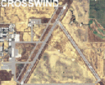
This scenery contains several revised files for my previously uploaded California Central Coast sceneries CCFSXMSG.ZIP and CCFSXMS.ZIP. These are the versions of my CCC scenery for FSX with MegaScenery Earth. The "G" version also requires Genesis Terrain Mesh but is the most complete version. Included here are revised AFCAD files for the major airports in those sceneries which will add interesting crosswind capability to C80, PRB, SBP, SMX and SBA airports. Additionaly, revised AFCAD and associated files for IZA, LPC, L52 and VBG are included. In some cases ground traffic has been added, a few glitches repaired and minor improvements effected. The crosswind AFCAD's for the 5 airports with tangential or crossing runways were revised using the technique developed by Jim Vile and executed by Airport Design Editor (ADEX). This procedure will unavoidably bolix up the ATIS runway advisories at the 3 tower controlled airports with ATIS (SBA, SBP and SMX) but will make all of the runways useable for AI traffic depending on wind conditions. This is not a problem at C80 and PRB since they are uncontrolled fields and have no ATIS available. Therefore, I've included revised AFCADs for SBA, SBP and SMX that do not have crosswind provisions that can be substituted if desired.
| Filename: | Crosswind_Runways_for_California_Central_Coast_Sce.zip |
| License: | Freeware |
| Added: | 7th January 2010, 22:05:25 |
| Downloads: | 514 |
| Author: | Al Wheeler |
| Size: | 194.42 KB |
| Category: Flight Simulator X - AFCAD Files | |
| Paramount Air Airport JY04 , NJ |
|
File Description:
Located 01 miles N of Green Creek, New Jersey on 20 acres of land, Paramount Air Airport is a private turf strip 2000' in length, although about 300' of it at the end of Runway 32 isn't in the best shape. The runway is 100' wide but closely hedged in by trees along both sides for the length of the runway. A hangar is past the end of Runway 14 but no services are offered for transient aircraft. Still, you can choose to start parked at the hangar if you wish. There is no hard surfaced runway so having your terrain mesh set as high as possible is recommended. No windsock is present, so know your weather (KWWD is very close by) and the airport is unlit so daytime VFR operations only are recommended.
Scenery constructed with use of satellite images/streetview/aerial photos - the author has not been there in person.
This scenery is meant to be used in conjunction with MegaScenery Earth New Jersey/Delaware 005. It is not required, but apron use is minimized to allow satellite scenery to show through as much as possible, and objects are placed based on the MSE textures - lack of it may make scenery look out of place.
| Filename: | Paramount_Air_Airport__JY04__NJ.zip |
| License: | Freeware |
| Added: | 20th April 2011, 16:42:48 |
| Downloads: | 179 |
| Author: | Drew Sikora |
| Size: | 418.37 KB |
| Category: Flight Simulator X - AFCAD Files | |
| Herr Mountain Airport (5NJ2), NJ |
|
File Description:
Located 02 miles N of Stanton, New Jersey, Herr Mountain Airport is a private turf strip. No aircraft are based here, so don't expect much except for ample room to land and take off again. There is a residence on the property, but no hangar or storage facilities. The runway is 2800x100 feet so not too hard to arrive and depart from. Approaching Runway 25 can be a slight challenge given that you need to level off your descent to cross over a mountain top before diving in to land. There is no hard surface runway, so you will be landing on terrain - be gentle! It's recommended to have your mesh complexity set as high as possible to get the full effect. The runway is not lit so daytime VFR operations only are allowed at this airport.
Scenery constructed with use of satellite images/streetview/aerial photos - the author has not been there in person.
This scenery is meant to be used in conjunction with MegaScenery Earth New Jersey/Delaware 001. It is not required, but apron use is minimized to allow satellite scenery to show through as much as possible, and objects are placed based on the MSE textures - lack of it may make scenery look out of place.
| Filename: | Herr_Mountain_Airport_5NJ2_NJ.zip |
| License: | Freeware |
| Added: | 1st February 2011, 23:06:28 |
| Downloads: | 187 |
| Author: | Drew Sikora |
| Size: | 422.37 KB |
| Category: Flight Simulator X - AFCAD Files | |
| Thomas Browne Airpark Airport (61NJ), NJ |
|
File Description:
Located 02 miles W of Glassboro, New Jersey, Thomas Browne Airpark Airport is a private turf strip 2000��80 feet. There is no hard-surfaced runway, which means you will be landing on terrain so it is recommended you set your mesh resolution as high as possible. Watch out for trees and buildings alongside and at opposite ends of the runway. Crop fields are planted to the south of the runway and border the runway. You won't crash if you run into them but it certainly won't put you in good favor with the field owners! Take caution to avoid the transmission line towers as they are not lit at night! Neither is the runway, for that matter, so daytime VFR operations only are recommended for this airfield.
Scenery constructed with use of satellite images/streetview/aerial photos - the author has not been there in person.
This scenery is meant to be used in conjunction with MegaScenery Earth New Jersey/Delaware 004. It is not required, but apron use is minimized to allow satellite scenery to show through as much as possible, and objects are placed based on the MSE textures - lack of it may make scenery look out of place.
| Filename: | Thomas_Browne_Airpark_Airport_61NJ_NJ.zip |
| License: | Freeware |
| Added: | 4th February 2011, 02:47:24 |
| Downloads: | 166 |
| Author: | Drew Sikora |
| Size: | 1.41 MB |
| Category: Flight Simulator X - AFCAD Files | |
| Strawberry Fields Airport (89NJ), NJ |
|
File Description:
Located 02 miles N of Mays Landing, New Jersey on 220 acres of land, Strawberry Fields Airport is a private turf/sand strip. SkyVector lists the runway as 2200' long, but as measured during development it is closer to 3000'. In addition to Runways 14 and 32, there is a second runway that is not listed in the airport directory and presumed closed. However if you need it in an emergency the numbers are 03 and 21 (no starts are available for these runways). This airport is not lit and is best used only during daytime VFR conditions. The windsock can be found at the intersection of the two runways and is also not lit. You will be landing on bare terrain so have your mesh complexity slider set as high as possible for best effect.
Scenery constructed with use of satellite images/streetview/aerial photos - the author has not been there in person.
This scenery is meant to be used in conjunction with MegaScenery Earth New Jersey/Delaware 003. It is not required, but apron use is minimized to allow satellite scenery to show through as much as possible, and objects are placed based on the MSE textures - lack of it may make scenery look out of place.
| Filename: | Strawberry_Fields_Airport_89NJ_NJ.zip |
| License: | Freeware |
| Added: | 17th February 2011, 07:55:52 |
| Downloads: | 204 |
| Author: | Drew Sikora |
| Size: | 1.75 MB |
| Category: Flight Simulator 2002 - Adventures | |
| Tahoe Emergency Landing |
|
File Description:
This is the situation file that will be used in the fly off contest at the 2002 Simmer's Convention and Exhibition in Lake Tahoe in September. This is one of two files that you will need to fly this situation. The other being the mesh scenery of the Tahoe region. Read the included PHOTO.TXT file carefully, as it describes the situation and what you should do to practice this approach.
| Filename: | Tahoe_Emergency_Landing.zip |
| License: | Freeware, limited distribution |
| Added: | 15th August 2002, 12:27:38 |
| Downloads: | 2,204 |
| Author: | AVSIM Online |
| Size: | 455.25 KB |
| Category: Flight Simulator 2004 - Scenery | |
| Neumuenster (EDHN) SG2 Update |
|
File Description:
FS2004 Scenery EDHN_SG2 (Neumuenster/N-Germany)Update Only! This is a second time modified version for the VFR-"Scenery Germany 2" as there has been a wrong mesh height disturbing the AI Traffic. Sorry for the inconvenience caused. You have to exchange the whole scenery-folder! Will also work with the default scenery, but you need the texture folder or download the whole new scenery EDHN_2006 on this server
| Filename: | Neumuenster_EDHN_SG2_Update.zip |
| License: | Freeware |
| Added: | 18th April 2006, 22:19:10 |
| Downloads: | 976 |
| Author: | Uwe Schweitzer |
| Size: | 487.74 KB |
| Category: Flight Simulator X - Missions | |
| South French Alps Soaring Mission |
|
File Description:
You will fly a FSX standard DG808S glider around a course in the South French Alps, from Provence landscape to glacial areas of the National Park of the Ecrins.
The mission begins at GAP TALLARD (LFNA) with an aerotow.
Fly the seven turnpoints before landing back at LFNA Airfield.
The flight will be much more realistic with ground photo textures or at least a good mesh, read the details page.
| Filename: | South_French_Alps_Soaring_Mission.zip |
| License: | Freeware |
| Added: | 3rd June 2008, 23:56:52 |
| Downloads: | 2,205 |
| Author: | Daniel AUROUZE |
| Size: | 4.92 MB |
| Category: Flight Simulator 2004 - Scenery | |
| Rarotonga International Airport, Cook Islands. NCRG. |
|
File Description:
Welcome to Rarotonga, in the beautiful Pacific Island paradise of the Cook Islands.
This scenery is designed and built to fit the RBE / Sim Pilot Experience "Cook Islands Scenery" (payware), by Christian Stock.
It has not been tested in the freeware Cook Islands Mesh that is available, or in FS9 default.
Scenery contains some custom items (textures included). Scenery requires some EZ Scenery Object Sets (see INSTALL instructions for details).
| Filename: | Rarotonga_International_Airport__Cook_Islands__NCR.zip |
| License: | Freeware, limited distribution |
| Added: | 22nd January 2009, 15:25:51 |
| Downloads: | 1,624 |
| Author: | Lawrie Roache |
| Size: | 1.89 MB |


© 2001-2026 AVSIM Online
All Rights Reserved
Privacy Policy |