
Where Flight Simulation Enthusiasts Gather from Around the World!
AVSIM Library - Search Results

| Category: Flight Simulator X - Aircraft Repaints, Textures and Modifications | |
| B-24 USAAF 376th BG "Lady be Good" |

|
File Description:
Following an April 4, 1943 bombing raid on Naples, Italy, conducted by the 376th Bomb Group, the Lady Be Good of the 514th Bomb Squadron failed to return to base. After attempts to locate the plane, its nine crewmen were classified as MIA, and presumed dead, believed to have perished after crashing in the Mediterranean.
Almost 16 years later on Nov. 9, 1958, several British geologists were flying over the desolate, sun-baked Libyan Desert. At approximately 400 miles south of Soluch, they spotted an aircraft on the sand. A ground party that reached the site in March 1959 discovered the plane to be a B-24D. The "Lady Be Good" had been found.
Evidence at the site indicated that the crew had become lost in the dark on return from Naples and had flown over their base and southward into the desert. As their fuel supply became depleted, the nine men aboard had bailed out but had disappeared while attempting to walk northward to civilization.
Intensive searches were made for clues as to the fate of the crew, and in 1960 the remains of eight were found, one near the plane and the other seven far to the north. Five had trekked 78 miles across the tortuous sand before perishing and one had gone an amazing 109 miles. In addition, they had lived eight days rather than only two expected of men in this area with little or no water. The body of the ninth man was never found.
Repaint for the Alphasim B-24 by Jan Kees Blom.
| Filename: | B24_USAAF_376th_BG_Lady_be_Good.zip |
| License: | Freeware |
| Added: | 11th October 2008, 13:11:09 |
| Downloads: | 386 |
| Author: | Jan Kees Blom |
| Size: | 7.61 MB |
| Category: Combat Flight Simulator 1 and 2 - Aircraft | |
| B25-B Mitchell Doolittle's Raiders A/C No. 40-2282 for The B24 Guy's OH |
|
File Description:
B25-B Mitchell Doolittle's Raiders A/C No. 40-2282, April 18, 1942. Painted over The B24 Guy's B25 Mitchell Overhaul Model. This was mission plane # 4. Pilot: Lt. Everett W. Holstrom, Jr., Co-pilot: LT Lucian N. Youngblood, Navigator: LT Harry C. McCool, Bombardier:
SGT Robert J. Stephens, Engineer/Gunner: CPL Bert M. Jordan. This bomb group attacked targets in the Tokyo area. The North American B-25B was not designed or intended for aircraft carrier use, but there they were, sixteen highly modified bombers sitting on the deck of the USS Hornet (CV-8). They were modified to carry bombs to Tokyo. The B-25s are launched from their maximum range, and flew over Tokyo, bombing several installations. The bombs did little damage, but managed to damage the Japanese carrier Ryuho while it is in drydock. Many of the planes then head to wherever they can make it, since the fuel will be empty before they reach a friendly airbase. All of the B-25 bombers are forced to bail out or crash land except one. Eleven crews are forced to bail out over China, 3 crash land, and the last landed safely at Vladivostok. The crew that landed in Russia was interned, along with the plane, for a while. The crews were all volunteer, and had no carrier experience, yet all sixteen of the bombers were successful on take-off. Texture, and Damage Files included. Note the three windows in both port and starboard bulkheads. By revev. Enjoy!
| Filename: | B25B_Mitchell_Doolittles_Raiders_AC_No_402282_for_.zip |
| License: | Freeware |
| Added: | 30th July 2006, 20:11:20 |
| Downloads: | 69 |
| Author: | Evan G. Butterbrodt |
| Size: | 1.57 MB |
| Category: Flight Simulator 2004 - Scenery | |
| Amundsen-Scott Station |
|
File Description:
The Amundsen-Scott South Pole Station is the American scientific research station on the high plateau of Antarctica. This station is located at the southernmost place on the Earth, the Geographic South Pole, at an elevation of 2,835 meters (9301 feet) above sea level.
Since the Amundsen-Scott Station is located at the South Pole, it is at the only place on the land surface of the Earth where the sun is continuously up for six months and then continuously down for six months. (The only other such place is at the North Pole, on the sea ice in the middle of the Arctic Ocean.) Thus, during each year, this station experiences one extremely long "day" and one extremely long "night". During the six-month "day", the angle of elevation of the Sun above the horizon varies continuously. The sun rises on the September equinox, reaches its maximum angle above the horizon on the summer solstice in the Southern Hemisphere, around 20 December, and sets onthe March equinox.
During the six-month "night", it gets extremely cold at the South Pole, with air temperatures sometimes dropping below -73 C (-100 F). This is also the time of the year when blizzards, sometimes with gale-force winds, strike the Amundsen-Scott Station. The continuous period of darkness and dry atmosphere make the station an excellent place from which to make astronomical observations.
This file has the apron and characteristics of the airport the coordenates are placed as far south FS allow it.
| Filename: | AmundsenScott_Station.zip |
| License: | Freeware |
| Added: | 17th October 2011, 22:02:39 |
| Downloads: | 668 |
| Author: | Anwar Gonzalez |
| Size: | 5.92 KB |
| Category: Flight Simulator 2004 - Scenery | |
| CYQS - St Thomas - Ontario, Canada *V1* |
|
Images related to this file:
File Description:
St Thomas is a town in Ontario around 12 miles south of London and less than 10 miles from the north shore of Lake Erie, with a population of just under 40,000. The airport (actually more of an airfield, as there are no scheduled flights) has three runways typical of an ex-military field, with one remaining hangar from RCAF flight training times in the 1940's, and the east-west runway now extended to just over 5,000 feet. The main presence at CYQS is a company in the crop seeding and spraying business over a wide area of Ontario; as a result there are several AT-802 planes based there which are included here as AI planes and also as parked scenery objects. To the west of the original apron area there are added taxiways to cater for a herd of new individual hangars wearing orange and white uniforms. There is fuel, runway lighting on 09-27, taxiway lights, visitor parking on the edge of the apron, and maintenance companies in the large hangars, plus a flight training group. A small terminal building sits quietly between hangars, waiting. Ditches along the road and around much of the airfield provide separation, which is why the fences are not continuous. I presume that the warning balls on the electricity cables were found to be necessary to persuade pilots not to land there; probably ski planes in winter, they tend to land anywhere so long as it has snow on it. This V1 version includes previous updates.
| Filename: | CYQS__St_Thomas__Ontario_Canada_V1.zip |
| License: | Freeware, limited distribution |
| Added: | 30th August 2015, 02:35:28 |
| Downloads: | 265 |
| Author: | Roger Wensley |
| Size: | 11.13 MB |
| Category: Flight Simulator 2004 - Scenery | |
| KLBB - Lubbock Preston Smith Intl - Texas V3.0.1 |
|
Images related to this file:
File Description:

Lubbock is another one of those little known, neglected airports that populate the
FS world. Avery simple airport, LBB somewhat feels like a little DFW. There is a very DFW-ish main terminal with fewer than
10 gates and plenty of space to grow. The only mainline service is courtesy Southwest, but several RJ's freqent Lubbock
several times per day along with the big freighters. This airport was built from the ground up with excellent detail,
and because of the sparse traffic, frame rates are excellent as well.
V2.0 Update:
Recently, Lubbock has moved their east-west runway 8/26 roughly 1000 feet to the East so as to eliminate runway incursions
by separation from the north-south runway 17R-35L. Version 2.0 reflects this modificaton. Several taxiways have been removed
or modified, and airport fencing has been altered to reflect the change.
V3.0 Update:
This update fixes some major errors mainly on the West side of the airport. The cargo ramp and some of the GA parking had been
found to be located in the wrong positions. They have been relocated and rebuilt to match GoogleEarth images. Also, the afcad
has been updated to line up with these changes along with airline parking updates at the main terminal. All the jetways have
been replaced with more accurate representations, and they have also been adjusted to match their current real world positioning.
v3.0.1 update:
There was a missing scenery library that has been added to the download, so now the jetways will appear if they had not before.
| Filename: | KLBB__Lubbock_Preston_Smith_Intl__Texas__V301.zip |
| License: | Freeware |
| Added: | 18th May 2013, 07:39:35 |
| Downloads: | 1,550 |
| Author: | FRFStudio.net / William Morgan |
| Size: | 8.17 MB |
| Category: Flight Simulator 2004 - Original Aircraft | |
| AerMacchi C.205 VELTRO (Greyhound) |
|
Images related to this file:
File Description:
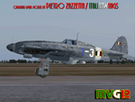
The Macchi C.205 (also known as MC.205,"MC" standing for "Macchi Castoldi") Veltro (Italian:Greyhound) was an Italian World War II fighter aircraft built by the Aeronautica Macchi.
The C.205 was a development of the earlier C.202 Folgore. With a top speed of some 400 mph and equipped with a pair of 20 mm cannon as well as 12.7 mm Breda machine guns, the Macchi C.205 Veltro was highly respected by Allied and Luftwaffe pilots alike. Regarded as the best Italian aircraft of World War II, in action it proved to be extremely effective, destroying a large number of Allied bombers and capable of successfully clashing on equal terms with such renowned fighters as the North American P-51D Mustang, but, although the C.205 was able to match the best Allied opponents in speed and manoeuvrability, it was introduced late in the conflict. Moreover, due to the poor Italian industrial capability of the time, only a small production run was delivered before the end of the war.
Italy's highest scoring ace, Adriano Visconti, achieved 11 of his 26 credited victories in the few weeks he was able to fly the Veltro, with the top scoring 205 Sergente Maggiore pilota Luigi Gorrini shooting down 14 enemy aircraft plus six damaged with the C.205.
VC only. GMax Models and Skins by Manuele Villa & Italianwings, Flight dynamics by Manuele Villa & Kikko Zanaboni. It also works (Tested), subject to some limitations, within FSX. By Manuele Villa/MVG3D, September 2012.
| Filename: | AerMacchi_C205_VELTRO_Greyhound.zip |
| License: | Freeware, limited distribution |
| Added: | 28th September 2012, 10:56:13 |
| Downloads: | 1,259 |
| Author: | Manuele Villa, Italianwings |
| Size: | 37.96 MB |
| Category: Flight Simulator X - Scenery | |
| Amundsen-Scott Station |
|
File Description:
The Amundsen-Scott South Pole Station is the American scientific research station on the high plateau of Antarctica. This station is located at the southernmost place on the Earth, the Geographic South Pole, at an elevation of 2,835 meters (9301 feet) above sea level.
Since the Amundsen-Scott Station is located at the South Pole, it is at the only place on the land surface of the Earth where the sun is continuously up for six months and then continuously down for six months. (The only other such place is at the North Pole, on the sea ice in the middle of the Arctic Ocean.) Thus, during each year, this station experiences one extremely long "day" and one extremely long "night". During the six-month "day", the angle of elevation of the Sun above the horizon varies continuously. The sun rises on the September equinox, reaches its maximum angle above the horizon on the summer solstice in the Southern Hemisphere, around 20 December, and sets on the March equinox.
During the six-month "night", it gets extremely cold at the South Pole, with air temperatures sometimes dropping below -73�°C (-100�°F). This is also the time of the year when blizzards, sometimes with gale-force winds, strike the Amundsen-Scott Station. The continuous period of darkness and dry atmosphere make the station an excellent place from which to make astronomical observations.
This file has the apron and characteristics of the airport the coordenates are placed as far south as FS allow it.
| Filename: | AmundsenScott_Station.zip |
| License: | Freeware |
| Added: | 17th October 2011, 22:01:33 |
| Downloads: | 1,295 |
| Author: | Anwar Gonzalez |
| Size: | 5.92 KB |
| Category: Flight Simulator 2004 - Scenery | |
| Naknek (5NK) and Naknek South (WSN) - Alaska, USA |
|
Images related to this file:
File Description:
Naknek and Naknek South are two towns close to the mouth of the Naknek River and on opposite banks. King Salmon is approximately 15 miles to the east. The canneries on both banks of the river are the reason for the existence of both towns and airfields, with fishing for salmon being the primary industry of the area. This takes place from the beach by individuals, by small boats in the river and the immediate sea area, and offshore by larger craft. There is a picture of one boat unloading in Naknek which will be known to anyone who has watched the most famous television fishing programme of all, Deadliest Catch. Cornelia Marie is better known for the crab fishing based in Dutch Harbor, but this area too is just as productive though without the drama. Naknek 5NK has two gravel runways and a float runway in the adjoining lake; all three are just under 2,000 feet long. Naknek South WSN has two gravel runways, 12-30 being 3,300 feet long and 04-22 2,260 feet. As the road connecting to King Salmon is on the north bank it is probable that more seasonal workers are brought into the southern canneries by air, hence the longer runway (and with PAPI on 12). Grant Aviation run scheduled flights into both and there are numerous seasonal charter flights. The AI is a further modification of that posted with King Salmon PAKN and includes these flights, and presumes that you have already downloaded PAKN.
| Filename: | Naknek_5NK_and_Naknek_South_WSN__Alaska_USA.zip |
| License: | Freeware, limited distribution |
| Added: | 29th April 2015, 20:44:31 |
| Downloads: | 217 |
| Author: | Roger Wensley |
| Size: | 6.09 MB |
| Category: Flight Simulator X - Aircraft Repaints, Textures and Modifications | |
| B-24 USAAF 489th BG "Sharon D" |
|
File Description:
This Ford-built B-24H was assigned to Lt Col Leon Vance, deputy commander of the 489th BG. It was Vance who had brought the aircraft from the US to Halesworth. The bomber was named after its pilot’s infant daughter Sharon, who had been born in 1942. Lt Col Vance was flying a different aircraft on the 5 June 1944 mission against a German coastal defence complex near Wimereaux, France-a mission in which the latter aircraft was lost, and for which Vance was awarded the Medal of Honor. He was the only B-24 crew member in the Eighth Air Force accorded this distinction whilst flying a mission from the UK. Vance was heading home to recover from combat wounds when he went down on a C-54 Skymaster carrying wounded and crippled veterans over the North Atlantic on 26 July 1944. In October 1946, at the age of four, Sharon Vance travelled via US Army Air Forces transport to Enid, Oklahoma (now home of Vance Air Force Base), for a ceremony in which Maj Gen James P Hodges gave her the Medal of Honor awarded to her father. Today, daughter Sharon Kiernan of San Diego, California, is an Air Force wife, and she helps to keep alive the memory of her father, and of the bomber named after her. The Sharon D retained its nickname throughout the war, and was eventually transferred to the 445th BG. It survived the conflict, and was eventually broken up for scrap.
Repaint by Jan Kees Blom for the AlphaSim 2008 Consolidated B-24 Liberator
| Filename: | B24_USAAF_489th_BG_Sharon_D.zip |
| License: | Freeware |
| Added: | 31st October 2008, 18:18:46 |
| Downloads: | 479 |
| Author: | Jan Kees Blom |
| Size: | 8.27 MB |
| Category: Flight Simulator X - Scenery | |
| RAF Church Fenton |
|
File Description:
RAF Church Fenton (ICAO: EGXG) was an Royal Air Force station in North Yorkshire, near the village of Church Fenton.
Plans for a new airfield adjacent to the village of Church Fenton were announced in June 1935, it was subject to protest from the local population particularly concerning the waste of valuable farming land and was close to an existing airfield not far away at Sherburn. Despite the protests construction started in early 1936 on the site, which was a mixture of private and West Riding County Council-owned farm land.
On 1 April 1937, the station was declared open and on 19 April the first station commander Wing Commander W.E. Swann assumed command. Within two months No. 71 Squadron RAF had arrived with their Gloster Gladiators.
Second World War
Opened in 1937, the station saw the peak of its activity during the years of the Second World War, when it served within the defence network of fighter bases of the RAF providing protection for the Leeds, Bradford, Sheffield and Humberside industrial regions.
During September 1940, it became home to the first RAF "Eagle squadron" of American volunteers being No. 71 Squadron RAF. The airfield was also home to both the first all-Canadian and all-Polish squadrons, with No. 242 Squadron RAF for the Canadians and No. 306 Squadron RAF for the Polish.
As technologies evolved, the first night fighter Operational Training Unit (54 OTU) was formed at Church Fenton in 1940 and stayed until 1942. Some of the squadrons stationed there flew the famous de Havilland Mosquito.
Source and more information can be found at
:- http://military.wikia.com/wiki/RAF_Church_Fenton
| Filename: | RAF_Church_Fenton.zip |
| License: | Freeware |
| Added: | 9th June 2017, 19:06:49 |
| Downloads: | 179 |
| Author: | Terry Boissel |
| Size: | 13.72 MB |


© 2001-2026 AVSIM Online
All Rights Reserved
Privacy Policy |